[St. John's] Transport development (Highways, Airport, and Public Transit)
This Thread is to discuss development in Highways, St. John's International Airport, and Public Transit in the St. John's Area
AIRPORT http://www.destinationstjohns.ca/ima...re/airport.jpg Airport Authority Unveils its 10-year Vision for Airport Improvements Quote:
METROBUS https://encrypted-tbn3.google.com/im...jeq0BaaWQmtceQ Transit study recommends increased investment and regional transit service Quote:
The Essential Transit Association: http://www.essentialtransit.com/inde...ion&id=stjohns Metrobus website: www.metrobus.com/ MOUNT PEARL TRANSIT Let's Talk Transit - Public Transit Study Quote:
Highways MAPS Team Gushue: http://www.tw.gov.nl.ca/publications...sion_route.pdf CBS Bypass: http://www.tw.gov.nl.ca/publications...y_proposed.pdf Team Gushue Highway completion http://www.pbase.com/image/142375758.jpg Quote:
|
I think this is a step in the right direction:
Quote:
|
Quote:
|
Mount Pearl is pretty dense, so in a way they could have a very efficient transit system. However, for it's relatively small population base and high car numbers, a big investment for its own transit may be a waste of money. Idealy Metrobus would be scrapped in favor of a regional bus service, but a more realistic approach here would be for Mount Pearl to increase investment in Metrobus services. I know the city isn't pleased with the service they get (2 busses for a population center of 25,000) but they're essentially getting what they pay for. Maybe they could pay a bit extra for a few extra routes, including maybe some that only run in the Mount Pearl area, and not in a circle from the Village through the city? I'm sure St. John's wouldn't mind, as long as Mount Pearl was fronting the bill for the Mount Pearl-only bus routes.
|
Here is some information regarding the Team Gushue highway and CBS Bypass extension for this thread:
The Telegram - Jan 24, 2012 Quote:
http://www.tw.gov.nl.ca/publications...sion_route.pdf Here is another link showing the CBS Bypass extension (this map is not as clear as the Gushue PDF). http://www.tw.gov.nl.ca/publications...y_proposed.pdf |
Mount Pearl could have small buses that go through the city and Metrobus could have one or two locations where they pick up people. The smaller buses could revolve around those area[s] so that people can still use Metrobus to get into St. John's but they'd have their own bus system that could get them into more areas of Mount Pearl. They could partner with Paradise.
|
statbass, Thanks for the links to the highway extensions.
The CBS one is currently pushed through on that route with the base in place. It looks ready for final prep and blacktop this year. Now that is only from either end. Maybe there is still lots of work in the center interchange or something else that we can't see. The Gushue Extension would be a great addition. Nice routing too. It's the first time I've seen it. I have to say I'd like to see more busses, but better traffic flow is also a hugh improvement to any city/metro area. |
Team Gushue Ext. Scope of Work
[QUOTE=statbass;5635824]Here is some information regarding the Team Gushue highway and CBS Bypass extension for this thread:......................
I also found this description of the work to be performed on the Team Gushue Extension. It is from the Canadian Environmental Assessment page; "Project Description (as posted in the Notice of Commencement) The Team Gushue Highway project will begin at the existing interchange on Kenmount Road, linking to the completed 2.3 km Bifurcation Road between the Outer Ring Road (the Trans-Canada Highway) and Kenmount Road. The project will terminate at the existing interchange between Commonwealth Avenue, Goulds Bypass, and Pitts Memorial Drive. In addition, a connector road, Pennywell Extension, will start at the intersection of the Old and New Pennywell Roads and end at a new interchange/intersection with the Team Gushue Highway just south of the Old Pennywell Road. The scope of work to be undertaken consists of the following components: - 7.1 km of four-lane divided, controlled access highway (100 km/hr max.), 1.5 km of a two-lane connector road (Pennywell Extension), and two (2) drainage culverts at Kitty Gaul's Brook and Flynn's Brook; - Six new interchanges/intersections constructed to connect with existing roads at the following locations: (i)Twinning of the Kenmount Road Overpass - $1,900,000; (ii)Pennywell Extension - $1,800,000; (iii)Captain Whelan Drive/George's Pond Road - $1,800,000; (iv)Topsail Road - $5,500,000; (v)Brookfield Road (east of Pearltown Road) - $3,000,000; and (vi)Brookfield Road between Heavy Tree Road and Tobin's Road. - Two (2) non-connecting overpasses over the Old Pennywell Road and Blackmarsh Road; and, - A long span culvert at the Waterford River. " |
I updated the info in the first post adding highways, thank you for the info however i couldnt figure out a way to put an image of the maps in the post
|
Quote:
Mount Pearl could run probably 3 routes in the city at all times, maybe 4-5 for the busier rush hours and route them into a central location to meet Metrobus. I don't know Mount Pearl very well, but I would assume that if they operated a system just within their city they would get decent ridership numbers to the industrial parks. The key to the system would be Metrobus putting in a good connector from Mount Pearl to the institutes and downtown St. John's. |
Quote:
http://www.pbase.com/image/142375758.jpg |
:previous: Thank you
Overpass Project Waiting for Warm Weather Quote:
|
Street Repair Plans Announced
Quote:
|
Some updated information regarding the CBS bypass extension:
Bridge work tendered for C.B.S. bypass extension Source: The Telegram, April 16, 2012 Quote:
|
Hard to tell by looking at the Bifurcation Road route map, but does anyone know if the highway is going to cross over Blackmarsh Road via and overpass or go under Blackmarsh Road. Surely they wouldn't be putting a intersection there would they?
|
Blackmarsh Road over/under pass
I understood that Blackmarsh road was a non-connecting overpass, but I've heard people say it's an underpass. Looks to me like an overpass, by the amount of material they are piling up on the North side. Here's a description that was posted a few weeks ago -
The scope of work to be undertaken consists of the following components: - 7.1 km of four-lane divided, controlled access highway (100 km/hr max.), 1.5 km of a two-lane connector road (Pennywell Extension), and two (2) drainage culverts at Kitty Gaul's Brook and Flynn's Brook; - Six new interchanges/intersections constructed to connect with existing roads at the following locations: (i)Twinning of the Kenmount Road Overpass - $1,900,000; (ii)Pennywell Extension - $1,800,000; (iii)Captain Whelan Drive/George's Pond Road - $1,800,000; (iv)Topsail Road - $5,500,000; (v)Brookfield Road (east of Pearltown Road) - $3,000,000; and (vi)Brookfield Road between Heavy Tree Road and Tobin's Road. - Two (2) non-connecting overpasses over the Old Pennywell Road and Blackmarsh Road; and, - A long span culvert at the Waterford River. |
Here is the map showing the CBS bypass extension.
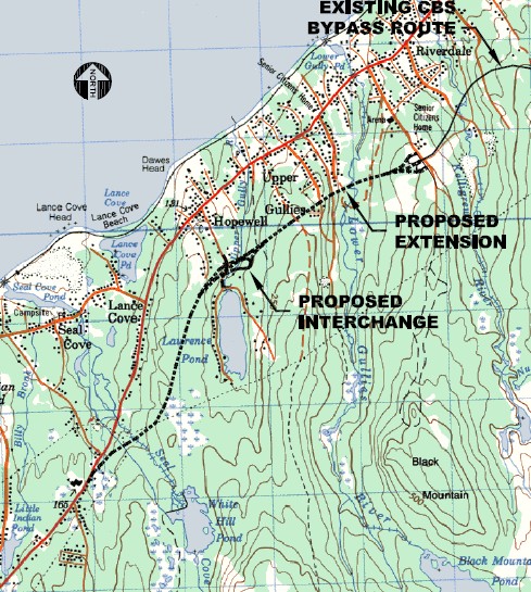 http://www.tw.gov.nl.ca/publications...y_proposed.pdf |
Does anyone know when the new runway lighting system will be installed at St. John's International Airport? Is is supposed to be this year? Given all the cancelled and delayed flight this past week, you'd think it'd be a good idea to put an utmost priority on this project. Cancellations due to fog happens every year around this time; the lighting system can't come soon enough. :whip:
|
A news story I watched over the weekend said the upgrade project would begin late this year and be completed in late 2013.
|
Quote:
|
| All times are GMT. The time now is 9:03 AM. |
Powered by vBulletin® Version 3.8.7
Copyright ©2000 - 2024, vBulletin Solutions, Inc.
 Prev
Prev