I first saw this image a few weeks ago in the window of a dry cleaners in the Magnolia Park section of Burbank, then found it on the web.
Mike Laroque
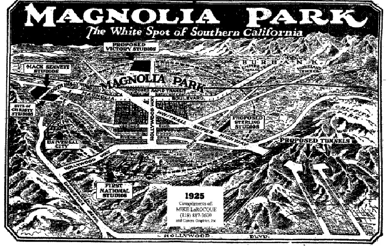
http://la.curbed.com/uploads/2007-02-magnoliapark.gif
It's interesting to me for a number of reasons...
Most starling are the "proposed tunnels" to Hollywood. Not only could you duck under the Hills as a handy short cut to Hollywood, but you could come into town on Bronson, Western, or Vermont. (There are a number of fire and access roads on the Hollywood side, but only one on the Burbank side. it starts near Travel Town in Griffith Park and is closed to motor vehicles about a mile up.)
Having hiked the "straight over the hill" route, I can tell you that it's
very steep and would would be a difficult route to Hollywood, with or without the mega-tunnels!
It's notable is that the tunnel route is an extension of Whitnall "Super" Highway. I had always wondered about this odd diaginal street, which is very broad, little used, and is basically a route for high voltage electric towers, with some park space below. (I had never seen the term "Super" used with it before.)
The western section of Hollywood way that intersects with Cahuenga is now called Barham of course, not Hollywood Way. I'd always wondered How Hollywood Way got it's name, since it dead ends at Olive, and does not go to Hollywood. I guess it did, before the Western section was named Barham.
Barham crosses the L.A. River (barely visible in the image) and then veers to the right at what is now Warner Brothers. However, Olive does not turn north, near Riverside, the alignment is much different.
I didn't know that Mack Sennett studio was off Magnolia, and not sure what "propsed Sterling Studios" was. Maybe this is what's now The Warner Brothers "Ranch" lot west of Hollywood Way?
The Burbank airport is about where "Proposed Victory Studios" is shown. But Hollywood Way actually bends northwest, about 2 blocks past Magnolia.
By the way, my little house in Burbank, built in the late 20's, is almost at the exact center of this map -- it's in the middle of the little triangular section, to the right of the word "Super".
I have no idea why it was called the "white spot".