This rendering has been posted before, but here's a bigger version.
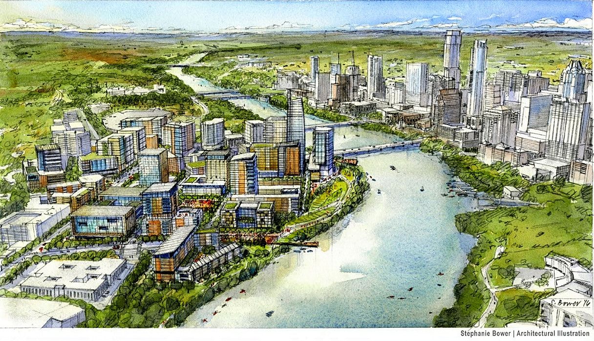
It came from the "final" South Central Waterfront Vision Framework Plan as adopted on June 16, 2016.
ftp://ftp.ci.austin.tx.us/npzd/Austi...estEdition.pdf
First, they talked about a "baseline buildout" - what could be done under existing regulations without any intervention from the City, but several of the parcels wouldn't see enough return on investment under the existing regulations and those parcels probably wouldn't be redeveloped in the next 5-7 years. Because of this, the public loses out on benefits like more open space, affordable housing, etc.
The rendering above and those below are based on a test scenario, where the developers are allowed to build more/higher than what current regulations allow to make it worth their while, and the public gets more benefits.
One of the things in the report is about a possible Statesman Waterfront Park.
Quote:
The Statesman Waterfront Park transforms this section of the 10 mile Anne and Roy Butler Hike and Bike Trail around Lady Bird Lake by adding a park that is unique among Austin's parks. Framed by a lively pedestrian market street to the south and a natural wetland habitat along Lady Bird Lake to the north, the park embraces Austin’s natural beauty as well as its vibrant and quirky energy.
At its eastern edge, an outdoor amphitheater, called the Bat Observation Theater, provides an ideal vantage point for Austinites and visitors to watch the iconic spectacle of Mexican Free-tailed bats emerging at sunset. At the same time, the amphitheater enhances access to the waterfront by creating
a gentle vertical transition from the Congress Street Bridge to the trail at waterfront trail below.
The center of the park serves as a Great Lawn that integrates stormwater ponds with active and passive recreation opportunities and access to the Cox Martketplace promenade. The western portion of the park, called the Pontoon Landing, features a boardwalk that could serve as a landing for a pontoon bridge across Lady Bird Lake connecting to the Waller Creek greenway.
Finally, the middle portion of the park becomes a tranquil space with a series of rain gardens that filter and purify runoff from nearby streets and development before releasing it into the lake.
|
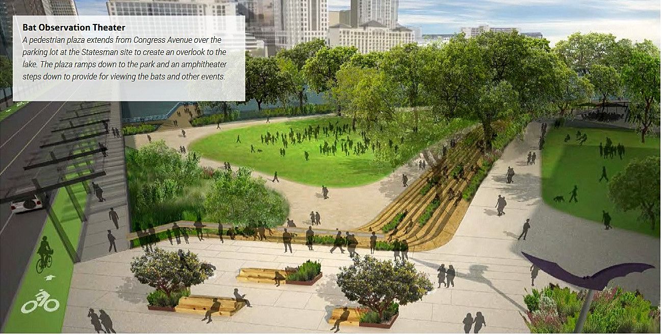
(There are also renderings of The Great Lawn, The Pontoon Landing, and the Barton Springs Plaza Rain Gardens in the report.)
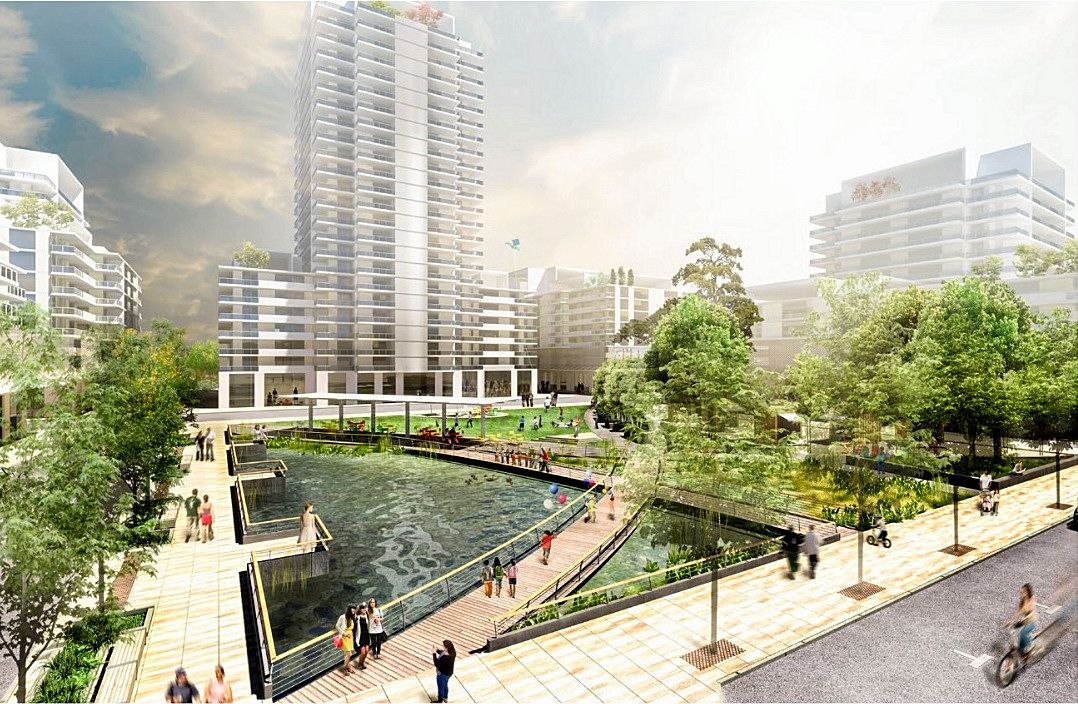
The report also envisions a Crocket Square and Cox Marketplace.
Quote:
Crockett Square provides the South Central Waterfront with a public
plaza counterpart to the lake edge and a social space for district
workers, residents and visitors. Its edges are highlighted by street
trees and raingardens.
The Square’s primary circulation paths define three key areas of
program within the square. An urban demonstration wetland in the
southeast corner is both a display of district-level water strategies
and a play-and-learn discovery garden for kids and kids-at-heart.
To the north, a bermed central lawn gently sculpts four small
amphitheater spaces, places where people can gather, eat, sunbathe,
or take in a movie from a small bandshell. The plaza also includes
a large tree-lined plaza, gridded with small fountains that entice play
and contact with water or are turned off so that a farmer’s market or
other vendor events can regularly enliven the plaza.
The Square has both grand spaces for congregation as well as
smaller spaces for friends, lovers or quiet reflection. Small look-outs
edge over the wetland area for views across the water to the park and
forested cloister seating creates more intimate seating moments. A
lengthy pergola along the Square’s primary walking path also serves
as a canopy for the Cox Marketplace, where food trucks and other
entrepreneurial innovations and events can spring up periodically.
|
From Page 102 of the report:
Test Scenario Development Program
Quote:
The Financial Framework requires private properties to "buy-in" to the Vision by building the public realm on-site, as well as financially contributing to city-led improvements. To incentivize property owners to contribute, their costs must be offset through increased development allowances.
The Test Scenario is a “what if” financial model to calibrate the additional development needed beyond existing entitlements to incentivize private
properties to participate in the Vision. The map below shows the Test Scenario on “tipping parcels” – properties most likely to redevelop within the
next 15 years. Under the Test Scenario, private properties ultimately pay for the whole public realm vision through on site improvements and the
recommended Funding Toolkit on page 97.
|
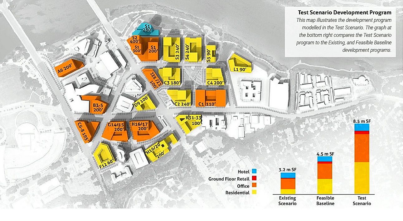
Most of the buildings depicted on the above map are 200 feet or less in height, but I see three residential towers of 240 feet, a hotel that's 280 feet, and two office buildings - one 300 feet tall and the other 400 feet tall.
There's a lot more in the report, but those were just some of the highlights.