Quote:
Originally Posted by BrownTown

Bingo. I say it all the time, but in virtually every one of the worst traffic cities you can go back to a map like this and see how NIMBYs caused highways not to be built resulting in the traffic problems because the highway network as built is incomplete.
|
Quote:
Originally Posted by KevinFromTexas
I actually don't mind the traffic. I'd rather have intact neighborhoods.
Even huge sprawling cities with massive highway systems still have bad traffic. Dallas and Houston both have some of the largest highway systems in the US and still have bad traffic. San Antonio, too. The last time we were in San Antonio we almost ended up in a multi-car wreck as three cars behind us rear-ended each other. One of them almost jumped the concrete barrier, and we were ~50 feet off the ground on an elevated highway. It was bumper to bumper traffic on a weekend. And I would say San Antonio's highway system is considerably more substantial than Austin's is.
|
I once saw a model from the early 1990s of what TxDOT had planned for the stretch of I-35 through downtown Austin. They wanted to add another 8-lane elevated deck above the current trenches and elevated split decks, and then construct large flyovers to access these all decks at regular intervals from the east-west downtown grid streets. It was determined that these flyovers would require ramps each running the length of 6 city blocks, which, combined with running length for ramp-entry yielding, meant that the flyover ramps from I-35 would have practically emptied directly onto Congress Avenue! With such flyovers reaching out 6 downtown city blocks on either side of the highway into both downtown and East Austin for a total additional total width of 12 city blocks, the new I-35 and its tangled tentacles of flyovers would have been wider than the original downtown grid itself. To accommodate the new flyover ramps, the east-west grid streets would probably have had to be widened, demolishing the surrounding facades. So outlandish was this mega-highway design, boasting in some trench areas 4-layers of roadway with additional flyovers above, that the model was immediately dismissed after its presentation before a horrified council.
Sadly, I no longer have a copy of a photo of this model, and I can no long find it online. Too bad, as all the flyovers and perpendicular ramps gave the model highway the peculiar appearance of a giant wooden centipede having landed from outer space and straddling the miniature city. I did find brief mention of the planning behind the model in a 2002
Austin Chronicle article: "
Born to be Reviled: Easing on down the road will be tough for TxDOT's I-35 expansion plan" (Dave Mann, Sept. 20, 2002).
It can and has been argued by the "Keep Austin Weird" crowd that if someone is moving to Austin to live in the suburbs and only commute through Austin to reach suburbs on the other side, perhaps they are missing the point of living in Austin. Demolishing Sixth Street to build a highway ramp to access Congress Avenue directly from I-35 is mindboggling in its anti-urbanism:
Austin's recognizable Sixth Street:
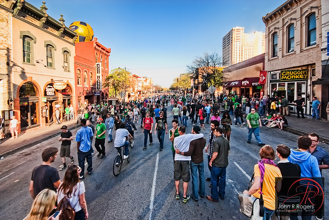
(Image by
John R Rogers on Flickr)
What they had planned for Sixth Street:

(Image from
Austin-American Statesman My Statesman.com)
Similar ramps would have also been at Fourth Street and in the front of the State Capitol. What were they thinking!? Equating people to only cars, and then counting only cars but not people.
Of course, I-35 downtown has never been so expanded, and it is a nightmare highway to drive through along with the rest of Austin's highways. Yet, Austin is still growing despite its notorious congestion and relatively small highway network. Indeed, its growth leads the nation and its downtown skyline has undergone the most dramatic increase in building construction in the U.S. over the past 20 years.
San Antonio makes a great contrast of the other extreme, for it readily pursued the rapid creation and expansion of its almost triple-ring highway network, such that in the 1960s its highways system was among the most extensive in the U.S. A
San Antonio Express-News article from the time period, "Bexar County Has Recorded Two Decades of Dramatic Progress in Highways" (Jan. 16, 1966), even boasted that the city "was to witness the growth of
a metropolitan highway complex that today ranks second only to Los Angeles County in California." Heart your heart out, Robert Moses! Two factors lead to this outsized complex: the concentration of national military bases around San Antonio in a logistical center midway between both coasts but furthest south from potential Soviet bombers approaching from over the northern pole, and the willingness of San Antonio civic leaders to purchase and grant land for highway construction in a federal program that would accelerate the prioritization of highway construction based in part on such local contributions. This was seen as getting a leg up on competitor cities for highways dollars, and as a way of opening access for local property holders with large exurban tracts
However, San Antonio's modern growth, even with this oversized highway network, has been comparatively lackluster. It has diffused its largest economic generators out into the suburban sprawl. USAA built a headquarters whose floor area nearly equaled one of the twin towers of the former New York World Trade Center, a significant construction for any city, but, instead of building it in the downtown core where its concentration of workers could additionally impact surrounding business, they built it out in the sprawl where its campus of workers now primarily impacts traffic. UTSA is even further out on the farthest edge of farthest loop. Meanwhile, traffic congestion has not been improved, with the population and the traffic problems merely spun out into edge city while the core was long sapped of vitality. The comprehensiveness of the large highway network has not especially helped San Antonio, and in many ways Austin, even with its smaller highway system and smaller population, has caught up with and surpassed San Antonio in economic dynamism.
_________
On the mall discussion, San Antonio's downtown mall at Rivercenter has a noteworthy caveat in the huge art deco Joske's Building, formerly the Joske's Department Store and later the Rivercenter anchor Dillard's. Joske's once billed itself as "the biggest store in the biggest state" and commanded a gateway site into Alamo Plaza, but as Dillard's it could barely fill the ground floor and basement as department store retailing was sucked away into the ring city following suburban flight. It had been largely in a retail holding pattern with empty floors as owners try to figure out how to redevelop it into a the base of a hotel tower. The more modern end of Rivercenter Mall directly faces the city's convention center and sports a boat dock for Riverwalk tours, however, it is also on a weak, uninteresting edge of the downtown core and even boasts flat parking lots behind the Alamo.