View Single Post
  #5017  
Old Posted Oct 27, 2017, 6:09 AM
mezzanine's Avatar
mezzanine mezzanine is offline
Registered User
 
Join Date: Aug 2002
Posts: 1,998
Quote:
Originally Posted by EastVanMark View Post

Here is a link to when the project itsef and when it was completed.

https://americastransportationawards...hange-project/

Below is a picture of the completed (somewhat) project. It is literally a few blocks from the old East-West Freeway.

https://cdn-images-1.medium.com/max/...Szv3zwg4g.jpeg


The distance between the two roadways is roughly the same if the viaducts had a sister road way on 4th Ave or on the waterfront.

This picture illustrates how close the 2 roadways were. The park east is in the very right of the picture. https://images.wisconsinhistory.org/...06001037-l.jpg


While in Milwaukee, they removed a section of viaduct that was redundant and not really needed, we here in Vancouver are removing a viaduct when we have nothing else to replace it.

I dunno, linking the reconstruction of the marquette interchange versus the removal of the Park East freeway IMO is a reach. if you look at the network geography, i would think that their effects are independent of each other:


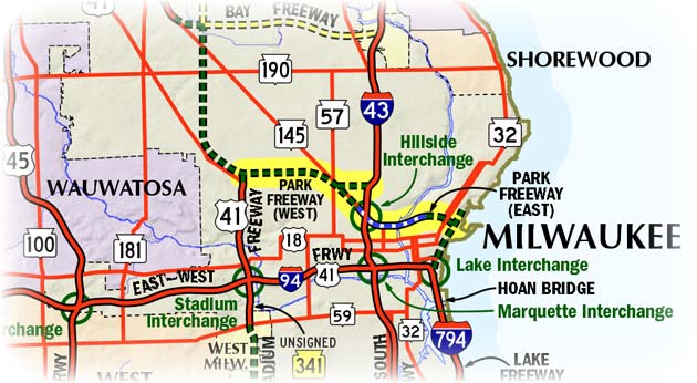
The dashed roads are the never-built freeways and the roads outlined in black are limited access freeways. You can see what the Park east was suppposed to do and why it was underutilised and not really part of the larger network.

other traffic studies prior to the park east removal also suggested that traffic effects would be more local to the stub and could be accommodated by expanding the surface grid after the removal, which is more analogous to vancouver.

Also of note - the cost for removal of the park east was $25 million (ignoring any increase in tax base revenue due to redevelopment/repopulation). For the Marquette reconstruction it was $810 million.
Reply With Quote