 Posted May 19, 2017, 6:56 PM
|
|
Registered User
|
|
Join Date: Aug 2012
Posts: 623
|
|
Quote:
Originally Posted by ethereal_reality

 Good find FW. I looked for it & wasn't able to find it.
I don't believe we have discussed compass trees on NLA, right?
"Last of the Four Compass Trees in Burbank." [1956?-1965?]
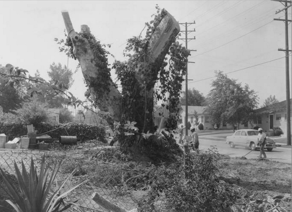 http://digital-library.csun.edu/cdm/...n/SFVH/id/4117
"These sycamore trees marked the gateway to the San Fernando Valley and served as a guide for travelers, as well as the padres who traveled from mission to mission. The trees also provided shade, wood to cook with, and water because they were located near fresh water springs. The trees were planted in a "V" formation and each tree pointed to a direction on the compass. The padres chose to plant the sycamores because they were used for this purpose in Europe. In Europe they were called the "plane tree" because they were one of the easiest trees to recognize and they stood out from the rest. The spot were these four trees were planted in Burbank was used as a camp and resting place. Don Juan Bautista de Anza, Frontier Captain and Military Governor of Sonora, was one among many who made camp here."
Location
http://digital-library.csun.edu/cdm/...n/SFVH/id/4117
"These sycamore trees marked the gateway to the San Fernando Valley and served as a guide for travelers, as well as the padres who traveled from mission to mission. The trees also provided shade, wood to cook with, and water because they were located near fresh water springs. The trees were planted in a "V" formation and each tree pointed to a direction on the compass. The padres chose to plant the sycamores because they were used for this purpose in Europe. In Europe they were called the "plane tree" because they were one of the easiest trees to recognize and they stood out from the rest. The spot were these four trees were planted in Burbank was used as a camp and resting place. Don Juan Bautista de Anza, Frontier Captain and Military Governor of Sonora, was one among many who made camp here."
Location:
"This particular tree was planted around 1817 and was located at 715 South Lake Street. Many of the trees branches were cut because they were deteriating and endangering the residents. Mrs. Pierina E. Lo Piccolo, founder of the Burbank Historical Museum, rescued the tree and paid for its removal after the owners of the property, Mr. and Mrs. Harry Lurtsema, graciously donated the tree to the museum. The tree is now located on West Magnolia Boulevard in Burbank."
So was this information written back when the photograph was taken (1950s/60s), or written recently (if recently, it implies the compass tree is still standing somewhere on W. Magnolia)
I have to say, if that's what the tree looked like 50 years ago, I can't image what it looks like today. (a stump?)
__ |
All four of our compass trees are now gone from their original location. There is now a "Compass Tree Park" on the location with a compass on the ground in concrete, some benches and some new Sycamores to give shade. They were planted there in 2002. It is a tiny, triangular park, located next to what is called the "Burbank Western Channel" originally a natural creek that came down from the north and eventually joined the LA River. It seems that the West Magnolia location would be sort of strange since the museum is located on Olive. The Burbank Website noted that the trees are no longer standing.

|