Here's a more ambitious set of fantasy maps than the last one I posted. They're sort of schematic so they aren't perfectly to scale, but it's pretty close. I've put these up on flickr so the size is a bit small.
The modes are:
1) Rapidbus/b-lines shown with narrow lines in light grey and dark grey
2) Trams (or maybe articulated trolleys) shown with narrow lines in bright colours
3) Skytrain shown with thick lines in primary colours
4) Regional rail shown with thick lines in pastel colours
First, the latter two modes:
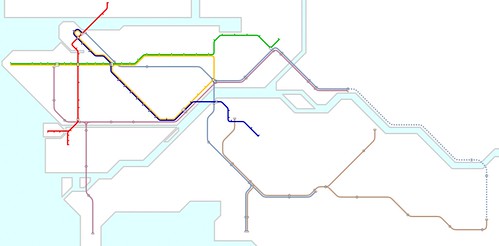
The blue dashed regional line is commuter rail like the West Coast Express, while the solid regional lines have regular bidirectional service every 30 minutes or something like that.
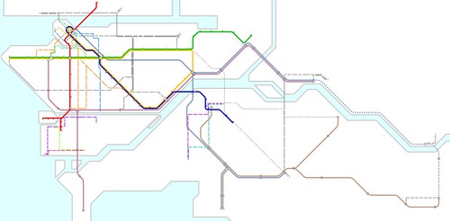
The stops that are close together on the brown regional line between Langley and Abbotsford are for Kwantlen in Langley and the University of the Fraser Valley in Abbotsford. Other stops on that section are at Abbotsford International Airport, Aldergrove, and Murrayville.
The brown regional line to Fort Langley has a stop for Trinity Western University/Highway 1 that might also have a park and ride facility.
edit: There are a couple places where the regional lines would conflict with freight. The regional lines shown would be double-tracked and dedicated to passenger service so they could maintain a schedule and so they could operate at relatively high speeds. In some places, like the BNSF line through the Central Valley and on the Southern line between Scott Road and Cloverdale, the line would be passenger-only except maybe at night. In others, like through Maple Ridge and possibly Langley City, two additional tracks would be built parallel to the freight tracks. Maybe a couple dozen houses would need to be acquired in Maple Ridge, but since these houses are 20 m from a freight main line I'm sure the owners aren't particularly attached to them.
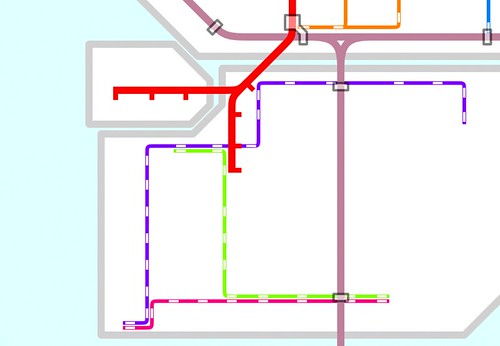
A close-up on Vancouver showing all four modes:

The orange tram lines use the Georgia Viaduct and Burrard Bridge. These could be articulated trolleys or trams.
The gold tram line on Robson connects to the future combined BCIT/Emily Carr/UBC/everything campus on the False Creek Flats.
The blue tram line follows Cordova through what's left of Japantown (as part of Portland-esque revitalization initiative).
The purple regional line stops at Arbutus/Broadway with a transfer to the Millennium line and the orange tram/trolley line. There is a transfer to the Canada line at Marine Drive station for a downtown connection as well.
A close-up on Surrey showing all modes:

The brown regional line between Surrey Central and Newton follows the hydro right-of-way.
The blue tram line connects Newton to the Kwantlen campus in Surrey.
The purple tram line on Scott Road is part of a strip mall revitalization initiative. The strip malls here are spaced at 800-m intervals, just like the stations on the tram line. These large greyfield sites are already consolidated.
A close-up on Richmond showing all modes:
The purple regional line follows the existing right-of-way along Shell Road.
The purple tram line follows the existing right-of-way on Railway for much of its length, then takes Lansdowne for a transfer to the Canada line and a stop outside Kwantlen's Richmond campus. If the Garden City lands was removed from the ALR, the tram line could continue into the site. As it's shown, the tram line turns up Garden City and then back onto an existing right-of-way north of Bridgeport by the night market with a transfer stop on the regional line before continuing through the large business district in East Richmond.
Finally, a map showing all modes:
Dark grey B-lines dominate a Willingdon busway, with other lines on Hastings, 41st, Marine Drive/3rd/Main/Cotton on the North Shore, and 200th street in Langley. A B-line connects Metrotown to uptown New Westminster, two B-line routes connect to Capilano University and the Maple Ridge campus of Douglas College, and three routes go to SFU and BCIT. Further east, a Clearbrook B-line runs down the middle of South Fraser Way between regional stations at Abbotsford International and Abbotsford, and another connects the University of the Fraser Valley campus in Mission to the Mission regional station.
Let me know if these are too small to read