archcityhomes.com
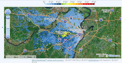
this is a 10 year old map, and property values are much higher now in the city (in the middle and south), and much much much higher in the inner pre-war suburbs in the middle. nonetheless it very plainly shows the favored quarter around and west of forest park, right down the center. west is obviously upwind of city factory corridors as well as the huge concentrations of Illinois-side industry.
the center-to-west corridor is also the highest elevation area in the close-in areas, kind of a saddle between the rivers, historically far less pollution, cooler temperatures in summer, less flooding, etc.