HomeDiagramsDatabaseMapsForum About
     

Go Back   SkyscraperPage Forum > Regional Sections > Canada > Atlantic Provinces > Halifax > Urban, Urban Design & Heritage Issues


Reply

 
Thread Tools Display Modes
     
     
  #41  
Old Posted Sep 23, 2009, 11:57 PM
hfx_chris hfx_chris is offline
Registered User
 
Join Date: Apr 2007
Location: Dartmouth, NS
Posts: 1,450
...bridge or tunnel?
Reply With Quote
     
     
  #42  
Old Posted Nov 16, 2009, 9:03 PM
Dmajackson's Avatar
Dmajackson Dmajackson is offline
Moderator
 
Join Date: Feb 2008
Location: B3K Halifax, NS
Posts: 9,342
The first phase appears to be paved and opened now;


Reply With Quote
     
     
  #43  
Old Posted Nov 16, 2009, 11:17 PM
someone123's Avatar
someone123 someone123 is offline
hähnchenbrüstfiletstüc
 
Join Date: Nov 2001
Location: Vancouver
Posts: 33,694
Never expected to actually see this thing completed - it's been talked about for years.

What is that paved surface? Concrete? I don't see any of the gaps.
Reply With Quote
     
     
  #44  
Old Posted Nov 16, 2009, 11:37 PM
Dmajackson's Avatar
Dmajackson Dmajackson is offline
Moderator
 
Join Date: Feb 2008
Location: B3K Halifax, NS
Posts: 9,342
Quote:
Originally Posted by someone123 View Post
Never expected to actually see this thing completed - it's been talked about for years.

What is that paved surface? Concrete? I don't see any of the gaps.
Plain old asphalt actually its just really dirty.
Reply With Quote
     
     
  #45  
Old Posted Nov 17, 2009, 12:52 AM
Dmajackson's Avatar
Dmajackson Dmajackson is offline
Moderator
 
Join Date: Feb 2008
Location: B3K Halifax, NS
Posts: 9,342
Quote:
Originally Posted by someone123 View Post
Never expected to actually see this thing completed - it's been talked about for years.
I always belived that this section would always be built since there are no real obstructions to building it its the other phases that will take a lot longer to be planned and built. This section runs through forest with no development or bridges sticking into the path.

Heading south requires a new bridge to be built which means years of planning and negogiating with CN and then building the bridge without obstructing train traffic below.

Heading north theres developments abutting the railcut which means purchasing land to construct the trail. Also there's parks and a few more rail crossings to contend with.
Reply With Quote
     
     
  #46  
Old Posted Dec 17, 2009, 7:06 AM
worldlyhaligonian worldlyhaligonian is offline
we built this city
 
Join Date: Jun 2006
Posts: 3,801
This is starting to look really attractive and very safe and functional. This is how all bike trails should be instead of these dangerous little painted areas on rediculously busy streets.
Reply With Quote
     
     
  #47  
Old Posted Dec 17, 2009, 12:03 PM
Takeo Takeo is offline
Registered User
 
Join Date: Mar 2006
Location: Halifax
Posts: 595
Quote:
Originally Posted by worldlyhaligonian View Post
This is starting to look really attractive and very safe and functional. This is how all bike trails should be instead of these dangerous little painted areas on rediculously busy streets.
Apples and Oranges. But yes, it's great to see this trail finally start to take shape after so many years. I didn't think it would happen actually.
Reply With Quote
     
     
  #48  
Old Posted Dec 17, 2009, 8:24 PM
Dmajackson's Avatar
Dmajackson Dmajackson is offline
Moderator
 
Join Date: Feb 2008
Location: B3K Halifax, NS
Posts: 9,342
Quote:
Originally Posted by worldlyhaligonian View Post
This is starting to look really attractive and very safe and functional. This is how all bike trails should be instead of these dangerous little painted areas on rediculously busy streets.
But thoses are Halifax specials.

Anyways in the whole HRM I can only think of two sfely designed bike friendly paths; this (HUGA) and the new shared sidewalk in Mill Cove.
Reply With Quote
     
     
  #49  
Old Posted Dec 18, 2009, 5:55 AM
worldlyhaligonian worldlyhaligonian is offline
we built this city
 
Join Date: Jun 2006
Posts: 3,801
The Clayton Park bike lanes look like suicide zones... meaning you're brave to be on a bike with cars driving 60+ in close proximity with alot of twists and turns.
Reply With Quote
     
     
  #50  
Old Posted Dec 18, 2009, 12:07 PM
Dmajackson's Avatar
Dmajackson Dmajackson is offline
Moderator
 
Join Date: Feb 2008
Location: B3K Halifax, NS
Posts: 9,342
Quote:
Originally Posted by worldlyhaligonian View Post
The Clayton Park bike lanes look like suicide zones... meaning you're brave to be on a bike with cars driving 60+ in close proximity with alot of twists and turns.
The Bfd Hwy bike lanes around Clearwater are a lot worse.

The speed limit's 70km/h with cars pushing 80km/h+, there's guardrails with steep drop off, and the parking lots around Clearwater are free-for-alls. I personally never exceed 60km/h when I'm driving through the area its just too dnagerous.
Reply With Quote
     
     
  #51  
Old Posted Dec 19, 2009, 8:59 PM
worldlyhaligonian worldlyhaligonian is offline
we built this city
 
Join Date: Jun 2006
Posts: 3,801
Quote:
Originally Posted by Bedford_DJ View Post
The Bfd Hwy bike lanes around Clearwater are a lot worse.

The speed limit's 70km/h with cars pushing 80km/h+, there's guardrails with steep drop off, and the parking lots around Clearwater are free-for-alls. I personally never exceed 60km/h when I'm driving through the area its just too dnagerous.
Wow, that sounds super dangerous. Cities in europe have it right: they have dedicated biking lanes inside of the sidewalk as opposed to in traffic.

I think that there could be a really good bike path up the bi-hi from down by bayers rd up to bayers lake along the inside of the highway where it is currently just rock and trees... it would be amazing to put little bridges over the exits... there is sort of a path up as far as clayton park, but it could be alot better.
Reply With Quote
     
     
  #52  
Old Posted Dec 19, 2009, 9:02 PM
worldlyhaligonian worldlyhaligonian is offline
we built this city
 
Join Date: Jun 2006
Posts: 3,801
Particularly where school avenue and westerwald st empty out... the sidewalk literally ends... for no apparent reason. I find that whole area really unfriendly to pedestrians and bikes and it could be easily made better.
Reply With Quote
     
     
  #53  
Old Posted Dec 19, 2009, 9:03 PM
worldlyhaligonian worldlyhaligonian is offline
we built this city
 
Join Date: Jun 2006
Posts: 3,801
It could connect to the HUG at bayers rd.
Reply With Quote
     
     
  #54  
Old Posted Jan 25, 2010, 5:09 AM
Dmajackson's Avatar
Dmajackson Dmajackson is offline
Moderator
 
Join Date: Feb 2008
Location: B3K Halifax, NS
Posts: 9,342
From Spacing Atlantic

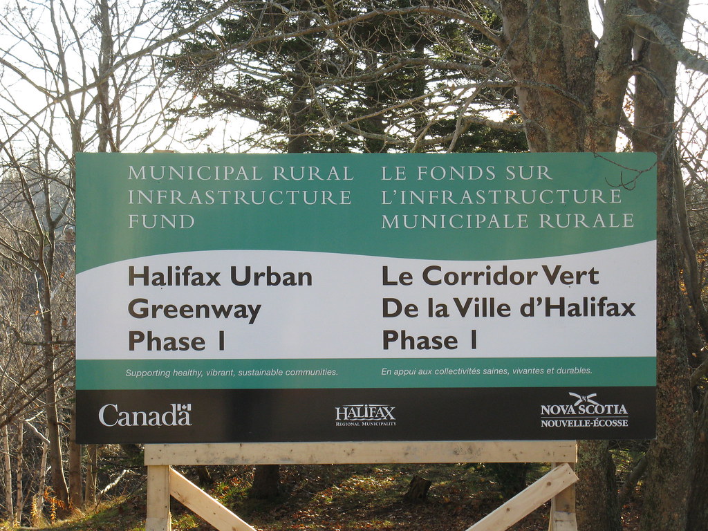
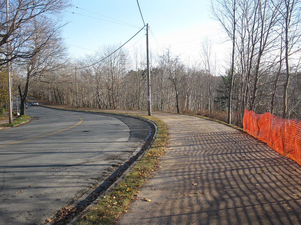
HALIFAX - Interested in learning more about the development of the District 14 active transportation trail and how it fits into the larger plan for the Halifax Urban Greenway? Here's an opportunity to hear members of the Halifax Urban Greenway Association and HRM staff speak on the development of the trail and how community members can become involved.

WHAT: Meeting on the Halifax Urban Greenway trail in District 14
WHEN: Wed, Jan 27th, 7pm
WHERE: Oxford School, 6364 North St (entrance off of Willow St, through the main school doors)
CONTACT: Councillor Jennifer Watts, 497-4748, jennifer.watts@halifax.ca
Reply With Quote
     
     
  #55  
Old Posted Jun 30, 2011, 4:40 AM
Dmajackson's Avatar
Dmajackson Dmajackson is offline
Moderator
 
Join Date: Feb 2008
Location: B3K Halifax, NS
Posts: 9,342
Just received an email that states Phase II of the HUG has begun its design stage. This section will run south from the existing trail (from Roxton Road) across the railcut to Pine Hill Drive.

There have also been improvements in Phase I including "parkette" upgrades at South Street and paving of the gravel section near Inglis Street.
Reply With Quote
     
     
  #56  
Old Posted Jan 6, 2012, 7:04 PM
Dmajackson's Avatar
Dmajackson Dmajackson is offline
Moderator
 
Join Date: Feb 2008
Location: B3K Halifax, NS
Posts: 9,342
Some tidbits from the organization's website (www.halifaxurbangreenway.org)

The remaining 10 percent of the Beaufort Avenue multi-use trail was paved by HUGA's contractor in mid-December. This approximately 400-foot stretch had been left gravelled as a temporary, narrow section for the last two years. The real multi-use trail is to go away from the street, close to the edge of the rail cut. However, this construction still awaits the acquisition of the required land from CN.

... Read More Here

HUGA made a presentation to the Property Committee of Saint Mary's University on November 30, 2011. This revolved around the need for a partnership with Saint Mary's that allows the multi-use trail to be developed on University land and to exit to Robie Street and/or Gorsebrook Avenue in lieu of the pedestrian bridge across the rail cut being constructed in the same year as the trail.

... Read More Here

1.Parkette

HUGA has improved the municipal property at the corner of South and Beaufort by adding access from the multi-use trail, through steps and an arched pagoda entrance. We have added a gravel footpath through the property to the sidewalk on South Street, two park benches, a picnic table and a trash bin. While the property has been thus converted into an attractive small park for trail users as well as the general community, it remains in residential zoning and theoretically is not protected from being sold for that purpose at any time.

2. Welcome Signage

We have designed, and are producing and installing a 4 by 10 foot welcome sign in the South Street parkette. The sign introduces HUGA’s new logo featuring the lady slipper wildflower which is so prevalent throughout the phase two lands, and which we hope to preserve to the greatest extent possible. The text on the sign highlights the three key themes of future interpretation signage along the trail – the history of the rail cut construction, access to the northwest arm, and the history of the original estate properties along the trail alignment. Our thanks to Councillor Uteck for providing financial assistance for our signage program

... Read More Here

Depending upon available funding, it is hoped that some part of phase two would be constructed in 2012 – possibly to the end of Greenwood Avenue or Robie Street
Reply With Quote
     
     
End
 
 
Reply

Go Back   SkyscraperPage Forum > Regional Sections > Canada > Atlantic Provinces > Halifax > Urban, Urban Design & Heritage Issues
Forum Jump


Thread Tools
Display Modes

Forum Jump


All times are GMT. The time now is 8:18 AM.

     
SkyscraperPage.com - Archive - Privacy Statement - Top

Powered by vBulletin® Version 3.8.7
Copyright ©2000 - 2024, vBulletin Solutions, Inc.