Quote:
Originally Posted by someone123

The thing with these generalizations is that Canada has about 1.5 old metropolitan areas that might have developed in this way. This analysis is pretty close to just asking why Montreal wasn't surrounded by bigger mill towns in 1900.
|
I don't think this is true at all. If you look at the US, most cities of equivalent size and age had a larger number of decent-sized, historical towns in their immediate city region. This is most pronounced on the Eastern Seaboard, but it's true of Midwestern cities like Chicago or Cleveland, and even recently-settled places like the Mountain West (Denver and Salt Lake being good examples).
Almost every Canadian city had a very feeble city region prior to the war, with few standalone towns with active city centres greater than 10,000 within commuting distance. Often, most cities just petered off into farmland with dirt roads.
Here's a picture of what was the edge of Toronto near Eglinton and Weston Rd. (this is deep within the city today, often considered to be inner city) around 1930. The picture is actually looking northeast (i.e. toward where the city would first grow):

You might as well be looking at the edge of a city in some Southwestern Ontario farming community 200 km away.
Here's the Jacques Cartier bridge being constructed to farmlands and small villages on the south shore:
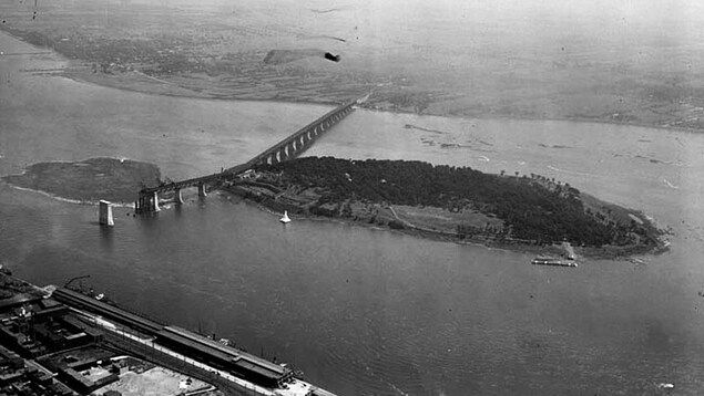
Here's what it would have looked like on the Montreal side:

So, on one side you have apartment neighbourhoods with 20,000/km2 and on the other side you have farmer's fields. If this were an American city, there would have been a Camden, NJ or Hoboken-sized place where Longueuil is, and they would have tried to bridge the St. Lawrence a generation earlier.
I'm not saying the US model of growth was better (although in places like Toronto and Vancouver, it sure would help to find cheaper urban neighbourhoods in outlying cities right now). If anything, it might point to the fact that Americans were always trying to leave the big city.


 Prev
Prev


 Linear Mode
