HomeDiagramsDatabaseMapsForum About
     

Go Back   SkyscraperPage Forum > Regional Sections > Canada > Atlantic Provinces > Halifax > Halifax Photos


Reply

 
Thread Tools Display Modes
     
     
  #1561  
Old Posted Dec 6, 2023, 5:47 PM
someone123's Avatar
someone123 someone123 is offline
hähnchenbrüstfiletstüc
 
Join Date: Nov 2001
Location: Vancouver
Posts: 33,694
Quote:
Originally Posted by OldDartmouthMark View Post
Maybe, but I can't help feeling that in modern times, supports for such structures are anchored into the seabed for some reason.
Kelowna has had floating bridges for a long time including the latest one, I would guess anchored, and the bridge crosses a (non-tidal) lake in an area not prone to hurricane-like storms.
Reply With Quote
     
     
  #1562  
Old Posted Dec 6, 2023, 6:08 PM
OldDartmouthMark OldDartmouthMark is offline
Registered User
 
Join Date: May 2010
Posts: 8,482
Quote:
Originally Posted by someone123 View Post
It was fine until it got hit by a hurricane type storm, and they come around every 5-10 years or so.

The bridge may not really have been such a tragedy if it was planned as an affordable semi-permanent structure. A bridge like the Brooklyn Bridge would have been a national level megaproject back then, and let's be honest about the chances of 19th century Canada paying for something like that in NS...
Halifax was still fairly prominent in Canada in the 19th century (though things were changing...), but yeah, the Brooklyn Bridge was not happening in Halifax at the time.

Given that east coast Canada is the only part of the country exposed to hurricanes, and a bridge had never been built across Halifax Harbour previously, one would surmise that the expertise involved with the design and building of the structure would have predicted normal forces (currents, ice, degradation, etc.), but perhaps didn't have enough experience with cyclical wind-driven waves and storm surge to understand what needed to be done to anchor the bridge in extreme conditions.

Quote:
Intercolonial Railway engineer P.S. Archibald designed the bridge in a concave form with the convex facing Bedford Basin in the hope this shape would help the bridge withstand ice slides each spring.

A Dartmouth man, Duncan Waddell, was in charge of construction for the huge stone pier upon which the swing section or “draw” of the bridge would rest, so vessels could be allowed to move into Bedford Basin. The stone pier, located near the Dartmouth shore, was constructed in about 35 feet of water, by driving piles into the gravel bottom to a depth of five or six feet. These acted as guides for building the pier, which was to hold the bridge, being built by the Starr Manufacturing Company of Dartmouth.

The wooden trestle-work of the bridge, constructed by M.J. Hogan of Quebec, rested on eight foot stone-filled cribs, spaced on the harbour bottom every 10 feet (3.0 m). The piles were then secured to the cribs. As the depth of the water was about 75 feet the piles had to be built in three sections, and spliced with eight-inch deals (basically an 8″ long plank) spiked into place. This proved to be extremely weak, especially when no form of side-bracing was used.
https://blog.halifaxshippingnews.ca/...0of%20Halifax.

The linked article (by forum member Ziobrop - who hasn't posted here since 2019) stated that this hurricane also caused damage to "wharves and shipping", so one would surmise that it was a significant storm, as wharves would typically be built as permanent structures.

The second structure disappeared in quiet conditions. Details are in the quote below from the same article.

Quote:
Suggestions were put forward by Dartmouth Town Council that it would be better to construct the railway line along the shoreline from Bedford to Dartmouth, rather than rebuild the bridge. However, the federal government decided to rebuild the structure, stating that the land route was not “deemed advisable.” Like the first bridge, it was poorly constructed and not braced. This time it was built in a straight line and thus made much shorter. Completed in 1892, the contractor was Connor’s of Moncton, New Brunswick.

About 2:00am, on July 23, 1893, almost two-thirds of the bridge slipped into the water. The last train had crossed about 6 hours prior. The cause of the breaking away of the Narrows Bridge was to be the result of sea worms. It was discovered that the piles were worm-eaten almost through between high-water and low-water mark. When the last train went over, it is assumed that these rotten supports gave way, but remained resting on the surface. Then, when the tide rose, the bridge desk floated up and the whole thing swept away.

The loss of the second bridge then led to the establishment of the rail line to Windsor Junction in 1896. The third harbour crossing is the Macdonald bridge.
These two failures and the subsequent line to Windsor Junction are probably why a rail bridge over the harbour was never attempted again. In fact it took over 30 years before any major discussions about a harbour crossing happened again:

Quote:
The firm of Monsarrat and Pratley were engaged to carry out studies of a possible high-level highway bridge linking the 2 sides of the harbour as far back as 1928. The bridge location between North Street in Halifax, and Thistle Street in Dartmouth was approved by Dominion Authorities and the British Admiralty in 1933. The 1945 master plan for Halifax assumed that this would be the location for the bridge, and suggested widening North Street to accommodate traffic. Dartmouth’s master plan of 1945 also assumed this would be the location.

The bridge was designed by Philip Louis Pratley, one of Canada’s foremost long-span bridge designers who had also been responsible for the Lions Gate Bridge in Vancouver. By the time design work began in 1950, he was working alone. The contractor was Dominion Bridge Company Ltd. When erected at a cost of CAN $10.75 million, the Macdonald Bridge was the second longest span of any suspension bridge in the British Commonwealth, after only Vancouver’s Lions Gate.
It's a fascinating article.
Reply With Quote
     
     
  #1563  
Old Posted Dec 6, 2023, 6:13 PM
someone123's Avatar
someone123 someone123 is offline
hähnchenbrüstfiletstüc
 
Join Date: Nov 2001
Location: Vancouver
Posts: 33,694
I always felt like Halifax was just a bit too small for its geography back in the pre-WW2 era. If it were 2x the size it would have gotten some nice classic looking bridges, including one over the Arm, and there probably would have been more of a mini Central Park feel with historic apartments around the Public Gardens and Commons. Fairview and Armdale would have been solidly prewar housing. It's possible that an underground streetcar would have been built as well, and maybe the streetcar system would have been kept.

Halifax is pretty rare in North America as a semi-major Georgian and Victorian town which stagnated in the late 19th and early 20th century but boomed later on. It is a bit like if Charleston or New Orleans were boomtowns today.
Reply With Quote
     
     
  #1564  
Old Posted Mar 15, 2024, 9:51 AM
OldDartmouthMark OldDartmouthMark is offline
Registered User
 
Join Date: May 2010
Posts: 8,482
Found this photo in an unrelated search. Looks to be about mid 1950s by the parked cars.


Source
Reply With Quote
     
     
  #1565  
Old Posted Mar 15, 2024, 12:24 PM
Keith P.'s Avatar
Keith P. Keith P. is offline
Registered User
 
Join Date: Mar 2006
Posts: 8,018
^^^ That photo was taken apparently in the mid-1950s. Does anyone know what those buildings were used for then? The wood structure on the right was quite the massive house, if that is indeed what it was.
Reply With Quote
     
     
  #1566  
Old Posted Mar 17, 2024, 1:17 PM
OldDartmouthMark OldDartmouthMark is offline
Registered User
 
Join Date: May 2010
Posts: 8,482
Quote:
Originally Posted by Keith P. View Post
^^^ That photo was taken apparently in the mid-1950s. Does anyone know what those buildings were used for then? The wood structure on the right was quite the massive house, if that is indeed what it was.
That's a good question. The Infirmary article doesn't mention what became of the two buildings in the pic after the new hospital opened on Queen Street in 1933. The pic I posted shows curtains in the window, so perhaps it was used to house people for awhile (it would probably still be owned by the Sisters of Charity - so maybe it was for people in need?).

It does mention that the building in questiion was the Waverley Hotel when they acquired it in 1886.

Before that, I gather that it was indeed the house of Judge Blowers until his death in 1842. It is huge for a house, but then he was quite a prominent judge:
Quote:
Sampson Salter Blowers was born on March 10, 1741 (or 1742), in Boston, to John Blowers and Sarah Salter. A Harvard law graduate, he became a wealthy lawyer in Boston. Between 1774 and 1783, he was either in England, Boston, Newport, or New York, depending on how the American revolution was developing. He finally sailed for Halifax in September of 1783, where he practiced as a lawyer. In December 1784, he was appointed attorney general of Nova Scotia, was elected to the House of Assembly in 1785, the Council in 1788, and many other positions until his retirement in 1832. He was instrumental in the end of slavery in Nova Scotia. He died in Halifax on October 25, 1842 (Blakeley, Blowers, Sampson Salter 2003).
https://www.hfxfirehistory.ca/histor...s-fire-company

From the link above he was also on the roster of the Governor's Fire Company in 1794. Blowers Street was named after him, and I read that apparently Salter Street was taken from his middle name.

I'll see if I can find out more. Interesting that I started looking for info on Dundonald Street, and now I'm looking into Judge Blowers house... history is full of rabbit holes.
Reply With Quote
     
     
  #1567  
Old Posted Mar 17, 2024, 7:05 PM
Saul Goode Saul Goode is offline
Registered User
 
Join Date: Dec 2020
Posts: 841
Quote:
Originally Posted by OldDartmouthMark View Post
Blowers Street was named after him, and I read that apparently Salter Street was taken from his middle name.
Interesting historical tidbit: in his time, his surname was pronounced to rhyme with "flowers".

I wonder how long it took for Nova Scotians to corrupt that into its present pronunciation.
Reply With Quote
     
     
  #1568  
Old Posted Mar 18, 2024, 12:07 PM
IanWatson IanWatson is offline
Registered User
 
Join Date: Feb 2013
Posts: 1,227
Quote:
Originally Posted by Saul Goode View Post
Interesting historical tidbit: in his time, his surname was pronounced to rhyme with "flowers".

I wonder how long it took for Nova Scotians to corrupt that into its present pronunciation.
Along with Berwick, Wickwire, and Framboise. I wonder what other names we've corrupted!
Reply With Quote
     
     
  #1569  
Old Posted Mar 18, 2024, 1:12 PM
OldDartmouthMark OldDartmouthMark is offline
Registered User
 
Join Date: May 2010
Posts: 8,482
Quote:
Originally Posted by Saul Goode View Post
Interesting historical tidbit: in his time, his surname was pronounced to rhyme with "flowers".

I wonder how long it took for Nova Scotians to corrupt that into its present pronunciation.
That is interesting! From now, I will start to pronounce the street name properly, and nobody will know what I'm talking about! Maybe I can make it catch on...
Reply With Quote
     
     
  #1570  
Old Posted Mar 18, 2024, 2:57 PM
Keith P.'s Avatar
Keith P. Keith P. is offline
Registered User
 
Join Date: Mar 2006
Posts: 8,018
Yeah, I never knew better for many years. But over time I heard of people with that name who pronounced it “BLAU-ers”.
Reply With Quote
     
     
  #1571  
Old Posted Mar 18, 2024, 4:05 PM
Saul Goode Saul Goode is offline
Registered User
 
Join Date: Dec 2020
Posts: 841
Quote:
Originally Posted by IanWatson View Post
I wonder what other names we've corrupted!
Gottingen springs immediately to mind.

It's also very common to hear Isleville pronounced "eyes-ville", especially among folks who were raised in that neighborhood.

Also Port Mouton and L'Ardoise, but of course they're not in Halifax.

Last edited by Saul Goode; Mar 18, 2024 at 4:22 PM.
Reply With Quote
     
     
  #1572  
Old Posted Mar 18, 2024, 4:20 PM
Saul Goode Saul Goode is offline
Registered User
 
Join Date: Dec 2020
Posts: 841
Quote:
Originally Posted by OldDartmouthMark View Post
That is interesting! From now, I will start to pronounce the street name properly, and nobody will know what I'm talking about! Maybe I can make it catch on...
I've tried that. I was immediately ridiculed for my ignorance of the "proper" local pronunciation.
Reply With Quote
     
     
  #1573  
Old Posted Mar 19, 2024, 11:34 AM
OldDartmouthMark OldDartmouthMark is offline
Registered User
 
Join Date: May 2010
Posts: 8,482
Quote:
Originally Posted by Saul Goode View Post
I've tried that. I was immediately ridiculed for my ignorance of the "proper" local pronunciation.
Ha... this is where the fun would begin!
Reply With Quote
     
     
  #1574  
Old Posted Mar 19, 2024, 11:40 AM
OldDartmouthMark OldDartmouthMark is offline
Registered User
 
Join Date: May 2010
Posts: 8,482
I did find another image of the house on NS Archives - it's referred to as "Blower's House" on the archive page. No further info as to its use after the Infirmary moved, though I did read a comment on a facebook page referring to a convent, which would make sense given its affiliation to the church.

I'm guessing late 1940s timeline?


https://archives.novascotia.ca/infor...chives/?ID=501
Reply With Quote
     
     
  #1575  
Old Posted Mar 19, 2024, 11:56 AM
OldDartmouthMark OldDartmouthMark is offline
Registered User
 
Join Date: May 2010
Posts: 8,482
Another one:

https://archives.novascotia.ca/photo...hives/?ID=6702

Here's a blow-up of the notes at the bottom (with some brightness/contrast adjustment). Note that this was torn down in August 1960 (and was a vacant lot for some three decades after that, IIRC). The date given for the photo is a mistake, as photography was in the process of being invented in 1828, and the building next to it was built in 1903 (plus... electric wires, etc.) - so perhaps the actual date of the photo is 1928?

Reply With Quote
     
     
  #1576  
Old Posted Apr 3, 2024, 5:42 AM
OldDartmouthMark OldDartmouthMark is offline
Registered User
 
Join Date: May 2010
Posts: 8,482
In recent reading, I came across a reference to the Morris Street School, but had never seen it (it was torn down before I was born), nor was I aware of its location, other than being on Morris Street (of course).

I found this photo on the NS Archives site:


I've always been a little in awe at how nice the old stone/masonry school buildings used to look in comparison to what was being built in the 1970s and later.

As for location, I read somewhere that it was near the intersection of Birmingham and Morris, and upon looking at Google streetside, was surprised to see that much of the granite blocking that was placed at the edge of the sidewalk and defined the entrance to school grounds was still in existence...

Reply With Quote
     
     
  #1577  
Old Posted Apr 3, 2024, 1:06 PM
Keith P.'s Avatar
Keith P. Keith P. is offline
Registered User
 
Join Date: Mar 2006
Posts: 8,018
Apparently replaced with a 1960s school called St. Mary's Elementary just west of that location. School building construction, being low-bid government contracts, is interesting. Back in the late 19th/early 20th century the relatively low cost of using stonemasons and the general level of engineering/design at the time made schools like the Morris St building possible - plus it gave the school facility a look of gravitas that was apparently desired. Then as we got into the 20th century such stonework became too expensive for govts so they went with brick. In more recent times we have tilt-up precast walls. One can only speculate what future ones will look like.
Reply With Quote
     
     
  #1578  
Old Posted Apr 3, 2024, 10:05 PM
OldDartmouthMark OldDartmouthMark is offline
Registered User
 
Join Date: May 2010
Posts: 8,482
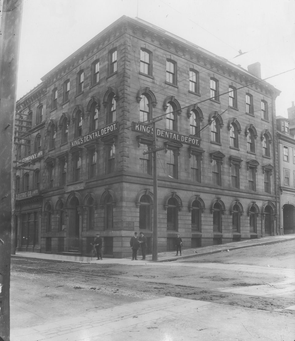
Keith, that's an interesting perspective. I had always chalked it up to a requirement for public buildings to appear impressive, and almost intimidating (like old churches as well), but you're right in that there was a time frame where we had a number of stone masons who had come from Europe to work on the Shubenacadie Canal. I have read where stone buildings were more doable back then because of the excess labour force who had those skills (especially after the canal project failed), plus materials were still readily available (and probably helped to keep the quarries in business). That said, I don't believe that similar stone buildings were unique to Halifax, though.

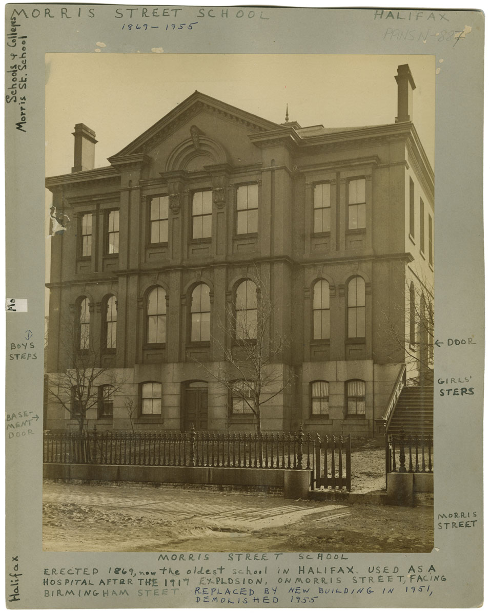
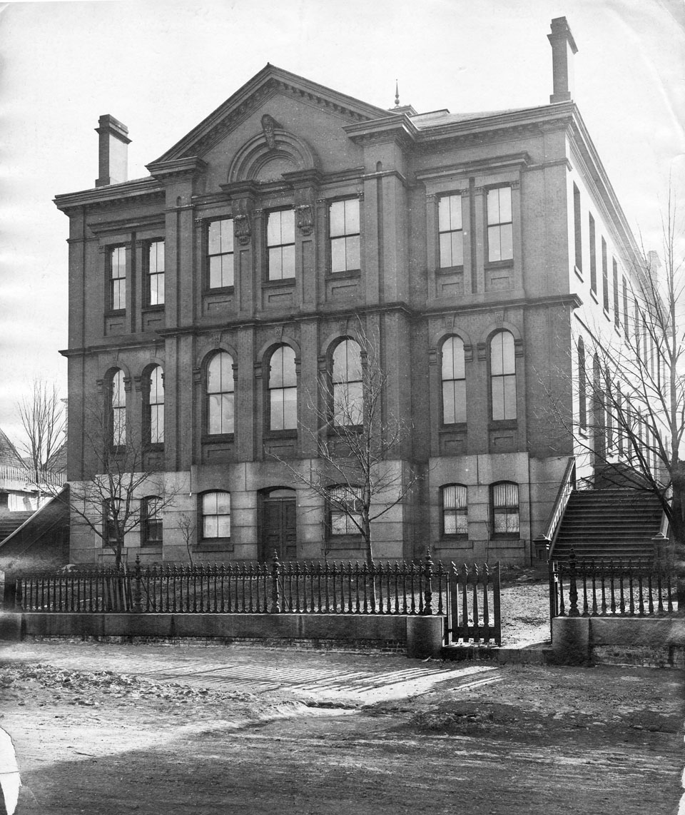
The architecture is quite impressive, especially for a small school, IMHO. Hate to say it, but to my eye most newer public buildings look like crap in comparison (highly opinionated as it is)...

Also on the NS archives site is what appears to be the same photo with notes on it:

Source

The notes at the bottom say it was replaced by a new building in 1951 and demolished in 1955.

Also of interest are the separate entrances for girls and boys. I never really understood this, and thought of it as an extension of the Catholic school model, but my elementary school (Greenvale) carried on this practice right into the 1970s. Girls and boys entered through opposite sides of the school, and recess and lunch breaks were spent outside on separate sides of the school. If you tried to go to the other side, the on-duty teacher would stop you from doing so. Oddly enough, once you got back inside, boys and girls mixed as usual. I never really understood this practice, and thankfully it disappeared shortly afterwards.
Reply With Quote
     
     
  #1579  
Old Posted Apr 5, 2024, 7:37 AM
OldDartmouthMark OldDartmouthMark is offline
Registered User
 
Join Date: May 2010
Posts: 8,482
Bank of Montreal, 184 Hollis Street, year 1905:


Source

Caption below reads:
Building first known as Doull & Miller Building and later Eastern Trust Company Building

Trying to figure out the location of 184 Hollis Street, since it was renumbered at some point (in the 1960s?), I referred to the 1878 Hopkins' City Atlas, and determined that it was at the corner of Hollis and Prince (labelled as "Doull & Miller").


Current numbering is 1690 Hollis, the site now occupied by the somewhat featureless Joseph Howe Building: https://maps.app.goo.gl/CVuRQ2px25ffd2Zq5


It's a shame that most of that corner block is just a dead zone to pedestrians now, with little visual interest. Just a place to walk by while you're going somewhere else.

Last edited by OldDartmouthMark; Apr 5, 2024 at 8:22 AM.
Reply With Quote
     
     
  #1580  
Old Posted Apr 5, 2024, 8:17 AM
OldDartmouthMark OldDartmouthMark is offline
Registered User
 
Join Date: May 2010
Posts: 8,482
Cook's building, 47-49 Upper Water Street at head or entrance to Black's Wharf, Date: 1910


Source

From the 1878 Hopkins' City Atlas, the location was right across the street from Waterside Centre, at the entrance to the Historic Properties mall.


Seeing what used to occupy that lot brings about some disappointment when you look at what is there now: https://maps.app.goo.gl/Azt7FsQSdFd3hKyH6


I wonder if it would ever be possible to replicate the building again, or at least the facade, to restore some missing character to Historic Properties.
Reply With Quote
     
     
This discussion thread continues

Use the page links to the lower-right to go to the next page for additional posts
 
 
Reply

Go Back   SkyscraperPage Forum > Regional Sections > Canada > Atlantic Provinces > Halifax > Halifax Photos
Forum Jump


Forum Jump


All times are GMT. The time now is 3:08 PM.

     
SkyscraperPage.com - Archive - Privacy Statement - Top

Powered by vBulletin® Version 3.8.7
Copyright ©2000 - 2024, vBulletin Solutions, Inc.