HomeDiagramsDatabaseMapsForum About
     

Go Back   SkyscraperPage Forum > Regional Sections > United States > Mountain West


Reply

 
Thread Tools Display Modes
     
     
  #2561  
Old Posted Nov 11, 2010, 11:23 PM
delts145's Avatar
delts145 delts145 is offline
Registered User
 
Join Date: Aug 2006
Location: Downtown Los Angeles
Posts: 19,381
Wonderful pics S.P. Thanks for the great updates, it's really appreciated.
Reply With Quote
     
     
  #2562  
Old Posted Nov 11, 2010, 11:46 PM
John Martin's Avatar
John Martin John Martin is offline
Registered User
 
Join Date: Jan 2009
Posts: 1,195
Wow, they're working fast on the viaduct. I knew it would be a lot lower (the old one was mainly going over a parking lot, which I think used to be a rail yard), but it still looks funny to me. I guess it's just that I don't usually see huge concrete columns like that so short.
Reply With Quote
     
     
  #2563  
Old Posted Nov 12, 2010, 12:20 AM
SLC Projects's Avatar
SLC Projects SLC Projects is offline
Bring out the cranes...
 
Join Date: Dec 2006
Location: Salt Lake City
Posts: 6,108
Quote:
Originally Posted by SLCdude View Post
I had no Idea they were that far in the construction progress. Is it still supposed to be finished 18 months after the old one was demolished? Also, It looks a little low to me.

Does the City Creek flow into the Jordan River? It seems like a waste of a creek to bury it underground.

One of the last photos shows a train parked under the new beams. Looks like there's plenty of clearance.
I'm glad the new beams are already up for the North Temple bridge.
__________________
1. "Wells Fargo Building" 24-stories 422 FT 1998
2. "LDS Church Office Building" 28-stories 420 FT 1973
3. "111 South Main" 24-stories 387 FT 2016
4. "99 West" 30-stories 375 FT 2011
5. "Key Bank Tower" 27-stories 351 FT 1976
Reply With Quote
     
     
  #2564  
Old Posted Nov 12, 2010, 12:30 AM
s.p.hansen's Avatar
s.p.hansen s.p.hansen is offline
Exurb Enjoyer
 
Join Date: Sep 2010
Location: The Great Salt Lake, Utah
Posts: 2,253
The Old Viaduct


Image by KSL


Image by T-Mac


Image by KSL


Image by libel_vox

-------------------------------------------------------------------------

TRAX Airport Line Construction / North Temple Street Viaduct Rebuild Update


Image by KSL

Video Link


A lot of energy in the Viaduct project is currently being expended on finishing a new underground City Creek (the real one) conduit.

My previous picture:


The picture I took today:


In this new picture City Creek is now running so dry (as is common and natural in the later fall / winter months) that they are able to divert the water through some flexible, smaller, black, temporary pipes.


The actual viaduct structure is progressing quickly.


Last edited by s.p.hansen; Nov 12, 2010 at 1:07 AM.
Reply With Quote
     
     
  #2565  
Old Posted Nov 12, 2010, 12:36 AM
s.p.hansen's Avatar
s.p.hansen s.p.hansen is offline
Exurb Enjoyer
 
Join Date: Sep 2010
Location: The Great Salt Lake, Utah
Posts: 2,253
Quote:
Originally Posted by SLCdude View Post
I had no Idea they were that far in the construction progress. Is it still supposed to be finished 18 months after the old one was demolished?

Does the City Creek flow into the Jordan River? It seems like a waste of a creek to bury it underground.
On the UTA website they have construction updates for all of their projects. They continually update the projects weekly and each week they keep saying that the N. Temple Viaduct is ahead of schedule. Originally the date (with the 18 months) was supposed to be sometime in August 2011, but if things keep progressing like they have I think we could see it open in June or July.

Before this current project on the creek it was already buried underground in a concrete tube. Salt Lake City has developed over the area that would have been graced by the flow of the surfaced creek; So instead of UDOT and UTA committing themselves to restore the creek to the surface all the way to the Jordan River (you guessed right), it's just easier for them to make the needed changes to the underground creek by keeping it underground.

Quote:
Originally Posted by SLCdude View Post
Also, It looks a little low to me.
The old Viaduct was ridiculously high which meant that it didn't flaten out at ground level until it got close to the end of the block across the street from the Gateway (400 West). The new Viaduct just simply can't be that high because the TRAX trains need to be able to be at ground level by the time they get to 400 West; they also need to be able to curve from heading East to heading South so that they can merge into the existing TRAX Lines. Having the Viaduct closer to the ground also makes it easier for pedestrians to bike over and walk over.

Also, I waited to take the last 3 pictures just so that I could get the train in the shot. The train clears the Viaduct with lots of room to spare.


Image by KSL


Image by KSL


The TRAX trains will be on the right side (your right when facing this picture) of the Viaduct instead of the center.

Last edited by s.p.hansen; Nov 12, 2010 at 1:02 AM.
Reply With Quote
     
     
  #2566  
Old Posted Nov 12, 2010, 4:07 PM
UTPlanner's Avatar
UTPlanner UTPlanner is offline
Registered User
 
Join Date: Dec 2007
Posts: 940
I was in a meeting last week and some of you may find it interesting that they are already months ahead of schedule but they have also already seen more than $10 million dollars in savings because of lower than anticipated bids.
Reply With Quote
     
     
  #2567  
Old Posted Nov 12, 2010, 5:36 PM
Orlando's Avatar
Orlando Orlando is offline
Registered User
 
Join Date: Nov 2007
Location: Seattle, WA
Posts: 3,990
Great! Now is a great time to build!
Reply With Quote
     
     
  #2568  
Old Posted Nov 12, 2010, 5:40 PM
scottharding scottharding is offline
Registered User
 
Join Date: Oct 2008
Location: Salt Lake City
Posts: 1,680
So exciting. It blows my mind to think that within just a years time (give or take) the West Jordan line, the West Valley line, the Airport line, the Front Runner South line, and the Sugarhouse trolley will all complete (not to mention the completion of CCC). Can any other metro in the country compare to that right now? Imagine what that's going to do for SLC in the next decade!
Reply With Quote
     
     
  #2569  
Old Posted Nov 12, 2010, 5:41 PM
scottharding scottharding is offline
Registered User
 
Join Date: Oct 2008
Location: Salt Lake City
Posts: 1,680
And I mean within a year of the first line completing, not a year from now. haha. Just thought I'd save people the trouble of correcting me.
Reply With Quote
     
     
  #2570  
Old Posted Nov 12, 2010, 5:49 PM
Orlando's Avatar
Orlando Orlando is offline
Registered User
 
Join Date: Nov 2007
Location: Seattle, WA
Posts: 3,990
Quote:
Originally Posted by scottharding View Post
So exciting. It blows my mind to think that within just a years time (give or take) the West Jordan line, the West Valley line, the Airport line, the Front Runner South line, and the Sugarhouse trolley will all complete (not to mention the completion of CCC). Can any other metro in the country compare to that right now? Imagine what that's going to do for SLC in the next decade!
With this many lines we will almost rival Portland. Though Portland, is continually placing new lines. However, Portland won't have nearly as much commuter rail as the SLC-Ogden-Provo metro will have with Frontrunner. They have a newly completed commuter line, that is so insignificant. Regarding street cars, I hope downtown gets a street car along 200 south from the Gateway to Presidents circle and down South or 1st again, and over to Sugarhouse. Portland has an exemplar street car line.
Reply With Quote
     
     
  #2571  
Old Posted Nov 15, 2010, 6:44 AM
s.p.hansen's Avatar
s.p.hansen s.p.hansen is offline
Exurb Enjoyer
 
Join Date: Sep 2010
Location: The Great Salt Lake, Utah
Posts: 2,253
Airport TRAX line ahead of schedule
North Temple will reopen next summer, not October
Quote:
By Steve Fidel, Deseret News

SALT LAKE CITY — Weekend placement of steel girders for a downtown viaduct puts the reopening of North Temple and the Utah Transit Authority's Airport TRAX line ahead of schedule.

The old viaduct at the north end of The Gateway closed April 18, completely closing North Temple on either side of the previous overpass. Street-level construction work also crowds traffic lanes along 400 West on the block north of EnergySolutions Arena.

"It's been challenging for businesses along North Temple that are dependent on traffic coming to and from downtown," UTA spokesman Gerry Carpenter said Monday. "It's a top priority to get that open again so we can minimize the impact of the project."

Crews moved the final girders for the vehicle traffic portion of the new viaduct in place over the Union Pacific and FrontRunner tracks Sunday morning. Separate framework for the rail portion of the new viaduct is scheduled for placement in March. "In the meantime we'll begin building road deck to get the road open next summer" instead of October as originally planned, Carpenter said.

"It's certainly moving along faster than we originally had anticipated," Salt Lake City Councilman Carlton Christensen said Sunday. "Having these girders up (is) an important part to getting the roadway portion opened again."

Once completed, rail passengers will be able to use stairs or an elevator to connect between a TRAX stop at the top of the viaduct and a FrontRunner stop beneath. UTA expects FrontRunner passengers headed downtown from the north will primarily use the new North Temple transfer station and most FrontRunner passengers arriving downtown from the south will continue to use the existing transfer station on 200 South.

The six-mile airport line is expected to open in 2013 with the line extending to Terminal 1 at the Salt Lake International Airport. All roadways affected by construction should be open next summer, Carpenter said. UTA expects 6,000 daily weekday riders to use the Airport TRAX line when it opens, with 14,000 weekday riders, on average, by 2030.

The viaduct portion of the project accounts for $71 million of the $350 million Airport TRAX line.

Animated depictions of the North Temple transfer station can be seen at www.youtube.com

View an animated depiction of the airport terminal "Welcome Center" at www.youtube.com
http://www.deseretnews.com/article/7...-schedule.html

Last edited by s.p.hansen; Nov 15, 2010 at 11:23 PM.
Reply With Quote
     
     
  #2572  
Old Posted Nov 16, 2010, 11:30 AM
delts145's Avatar
delts145 delts145 is offline
Registered User
 
Join Date: Aug 2006
Location: Downtown Los Angeles
Posts: 19,381
duplicate post

Last edited by delts145; Nov 20, 2010 at 4:38 AM.
Reply With Quote
     
     
  #2573  
Old Posted Nov 19, 2010, 4:24 AM
s.p.hansen's Avatar
s.p.hansen s.p.hansen is offline
Exurb Enjoyer
 
Join Date: Sep 2010
Location: The Great Salt Lake, Utah
Posts: 2,253
Calling All U of U Students!

Quote:
UTA Seeks Public Input on Transit System Changes in Salt Lake County
11/15/2010

The Utah Transit Authority invites the public to provide input to help develop changes to the transit system in Salt Lake County that will occur next summer. UTA has planned a series of public open houses for this purpose, and input may also be provided though an online survey and feedback form available at www.rideuta.com.

UTA will open the West Valley and Mid-Jordan TRAX light rail lines on Aug. 7, 2011. These lines represent a notable increase to transit service in Salt Lake County, and will expand frequent, high speed, reliable passenger rail service to communities on the west side of Salt Lake County. Opening the Mid-Jordan and West Valley TRAX lines will also bring significant changes to the existing bus and rail system. UTA is starting the process now and requests public input on creating an integrated and efficient system.

"Our goal is to create the best transit system we can within our established budget," said Michael Allegra, UTA general manager. "That is why we are asking the public to help us as we prepare to make changes next year."

Through early December, UTA is conducting a process known as 'scoping' - gathering information through focus groups, online and phone surveys, the UTA website, social media, and a series of public open houses. Through this effort, the agency seeks to better understand public preferences related to frequency, coverage, peak travel, weekend and evening service, fares, customer amenities and supporting services.

"This information will provide critical guidance as we develop planning scenarios," Allegra said. "No decisions have been made at this point. We want hear from the public on what their priorities are before we start putting lines on a map."

After the scoping phase, UTA will develop proposed service plan scenarios based on the public input as well as additional data and analysis. UTA will then go back to the public for additional input, presenting the proposed service plans for comment and refinement.

"We want to involve the public through the entire process-from scoping to scenario selection-to ensure the final decisions are the right decisions," Allegra said.

The following public open houses have been scheduled to provide an opportunity for the public to participate in the scoping process:

Nov. 30 - University of Utah
Marriott Library, Gould Auditorium
295 South 1500 East
11 a.m. to 1 p.m.
Reply With Quote
     
     
  #2574  
Old Posted Nov 19, 2010, 7:27 AM
i-215's Avatar
i-215 i-215 is offline
Exit 298
 
Join Date: Sep 2003
Location: Greater Los Angeles
Posts: 3,345
Met the developer of the proposed Utah Lake Crossing bridge at the open house tonight. Nutty old guy. I like him.

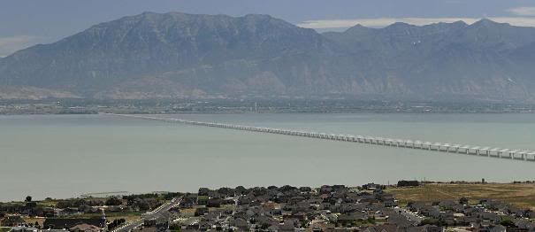
Looking at the renderings, I'd say the bridge actually makes Utah Lake look ... well, kind of awesome, actually. At full build out, it kind of reminds me of the Bay Area a little bit.

Cool features, too. No cobraheads. All the lighting is built in next to the roadway down low. All the utilities will be inside the concrete. The pylons end at the water surface level and only a set of seven pipes continue into the water. Really, compared to the nasty causeway on GSL, this thing really is pretty cool.

Anyway, I know the bridge is a pretty unpopular idea on here, but I really got better vibes after going to the open house tonight. The only think that ticks me off is the pedestrian path has been bumped to phase two. The old coot said something like, "Bikes can ride on the shoulder. We don't have to give pedestrians a place to walk. Why would they want to walk on a bridge anyway?" Nut.

He had lots of cool renderings, but when I asked to take pictures he said I should just download them from his web site. But now I can't remember what it is.

Edit: I managed to find one rendering. This is the one that kind of reminds me of the Bay Area:


I asked him too if there was going to be some icky ramp getting up onto the bridge. He says there's a 20-30 foot elevation change right near the water's edge, which will allow the road to go seamlessly from Vineyard (or Saratoga) right onto the bridge.

According to the posters, his thinking is that after paying off the financing on the bridge, each toll will generate $0.025 cents of revenue per trip, which could translate into millions of dollars per year during the financing stage of the bridge. And he was very out-in-the-open in admitting this is all about increasing property values on the west side of the lake, of which he owns quite a bit.
__________________
(I've sadly learned...) You can take the boy out of Utah, but you can't take the Utah out of the boy
Reply With Quote
     
     
  #2575  
Old Posted Nov 19, 2010, 6:27 PM
Orlando's Avatar
Orlando Orlando is offline
Registered User
 
Join Date: Nov 2007
Location: Seattle, WA
Posts: 3,990
I hope this bridge idea dies. We need to contain the mess that already is of the sprawl of Utah and Cedar Valley. We don't need more incentive for people to build out there when there is plenty of land on the west side. We don't need more incentive for people to build out there when it requires more a lot more public money and infrastructure to support those fools who decided to move over there in the first place.
Reply With Quote
     
     
  #2576  
Old Posted Nov 19, 2010, 9:31 PM
SLCdude's Avatar
SLCdude SLCdude is offline
Lurker
 
Join Date: Mar 2010
Location: Salt Lake City
Posts: 836


Agreed. I don't know too much about Utah County, but it looks to me like there is plenty of undeveloped land near Lehi. I'm also opposed to a 5+ mile bridge over Utah Lake because of environmental and recreational impacts.
Reply With Quote
     
     
  #2577  
Old Posted Nov 19, 2010, 9:45 PM
John Martin's Avatar
John Martin John Martin is offline
Registered User
 
Join Date: Jan 2009
Posts: 1,195
Well, really, who would want to walk 5 miles on a bridge over Utah Lake?
Reply With Quote
     
     
  #2578  
Old Posted Nov 20, 2010, 4:50 AM
scottharding scottharding is offline
Registered User
 
Join Date: Oct 2008
Location: Salt Lake City
Posts: 1,680
Agreed. And that bridge looks like shit to boot.
Reply With Quote
     
     
  #2579  
Old Posted Nov 20, 2010, 5:06 AM
i-215's Avatar
i-215 i-215 is offline
Exit 298
 
Join Date: Sep 2003
Location: Greater Los Angeles
Posts: 3,345
Quote:
Originally Posted by Orlando View Post
I hope this bridge idea dies. We need to contain the mess that already is of the sprawl of Utah and Cedar Valley. We don't need more incentive for people to build out there when there is plenty of land on the west side. We don't need more incentive for people to build out there when it requires more a lot more public money and infrastructure to support those fools who decided to move over there in the first place.
That smacks of social engineering, imo. Besides, in Utah there's no way to stop sprawl. Legislature passing an urban growth boundary? Pffft.

What about those fools, who in 1945 decided to move "all the way out" to Holladay. Gasp!

It's called growth. It happens. We can't legally stop it. Either we plan for it (as the MPOs so wisely do) or we don't. Plus, if you look at world population projections, we'll never see the world double in population ever again. The growth will die down, quite a bit over the next hundred years.


(Now, to be fair: I do support Portland's UGB, simply because the Willamette Valley has the most fertile farmland in the world. But honestly, what along the Wasatch Front is worth saving? It's hardly a bread basket. And with more responsible landscaping and the uncoming avalanche of electric cars, what's the harm of a bit more sprawl?)
__________________
(I've sadly learned...) You can take the boy out of Utah, but you can't take the Utah out of the boy
Reply With Quote
     
     
  #2580  
Old Posted Nov 20, 2010, 9:22 AM
SLCdude's Avatar
SLCdude SLCdude is offline
Lurker
 
Join Date: Mar 2010
Location: Salt Lake City
Posts: 836


It's true that Utah in general is not the best place for farming, but the Wasatch Front and Utah Valley are quite fertile. I think it is important to consume locally produced goods in order to reduce shipping costs and emissions. If the western side of Utah Lake becomes a suburbia, we're not left with many locations for farming near the metro area. Maybe I don't know what I'm talking about, but It just seems strange to me to build a 5+ mile bridge over a lake so developers can build their own car-dependant suburbias.

From the American Farmland Trust's website:


Reply With Quote
     
     
This discussion thread continues

Use the page links to the lower-right to go to the next page for additional posts
 
 
Reply

Go Back   SkyscraperPage Forum > Regional Sections > United States > Mountain West
Forum Jump


Forum Jump


All times are GMT. The time now is 7:57 AM.

     
SkyscraperPage.com - Archive - Privacy Statement - Top

Powered by vBulletin® Version 3.8.7
Copyright ©2000 - 2024, vBulletin Solutions, Inc.