HomeDiagramsDatabaseMapsForum About
     

Go Back   SkyscraperPage Forum > Regional Sections > Canada > Alberta & British Columbia > Calgary > Calgary Area Photos & Videos


Reply

 
Thread Tools Display Modes
     
     
  #1  
Old Posted May 26, 2011, 8:21 PM
5seconds 5seconds is offline
Closed account
 
Join Date: Mar 2011
Posts: 935
Historic Maps of Calgary

I wasn't sure if this is the right place, but here goes.

I have been doing some research recently, and I have come across some great old maps of Calgary, that I think others might want to see too.

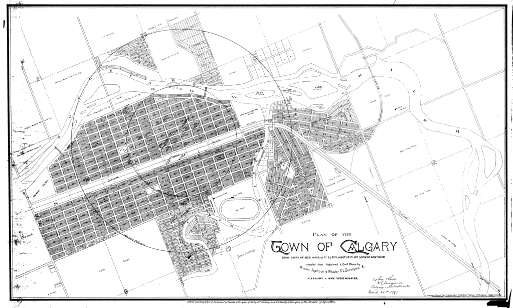
This is the oldest one I have seen so far, it dates from March 1891
Click here for a VERY Hi-Res version


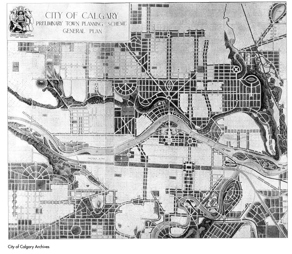
This is a conceptual plan done in 1913 of Calgary, by city planner Thomas Mawson:


With a stunning collection of drawings and photographs here
http://caa.ucalgary.ca/mawson Including this rendering of the approach to Prince's Island (Yes, this IS Calgary!):


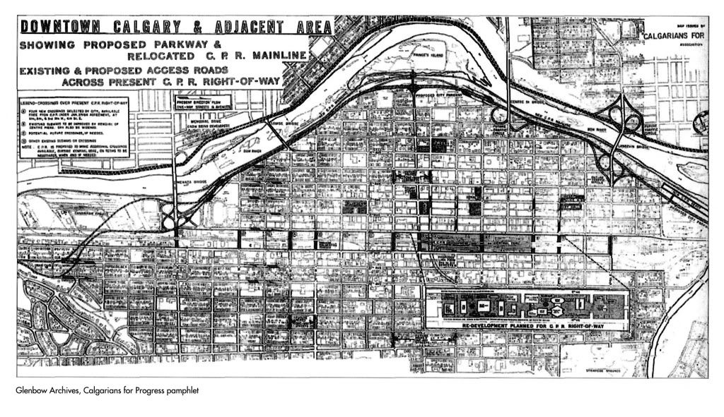
This is a map of the proposed Parkway in 1963, that would have seen the CPR mainline run along the river with a freeway beside it. Also, the further development of CPR lands downtown:


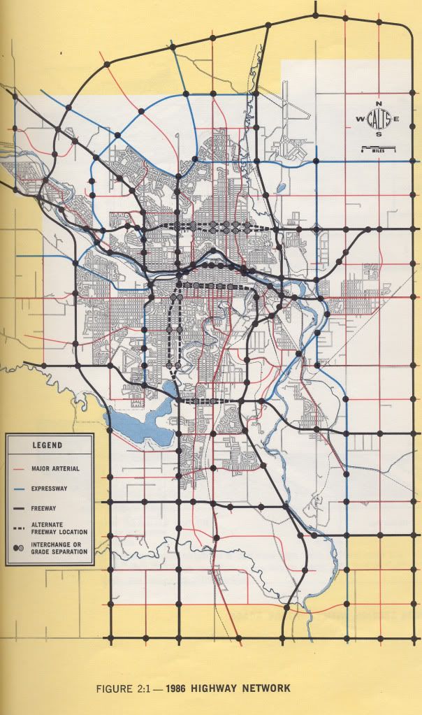
This is a rendering of what roads City planners in 1968 thought would be built by 1986:


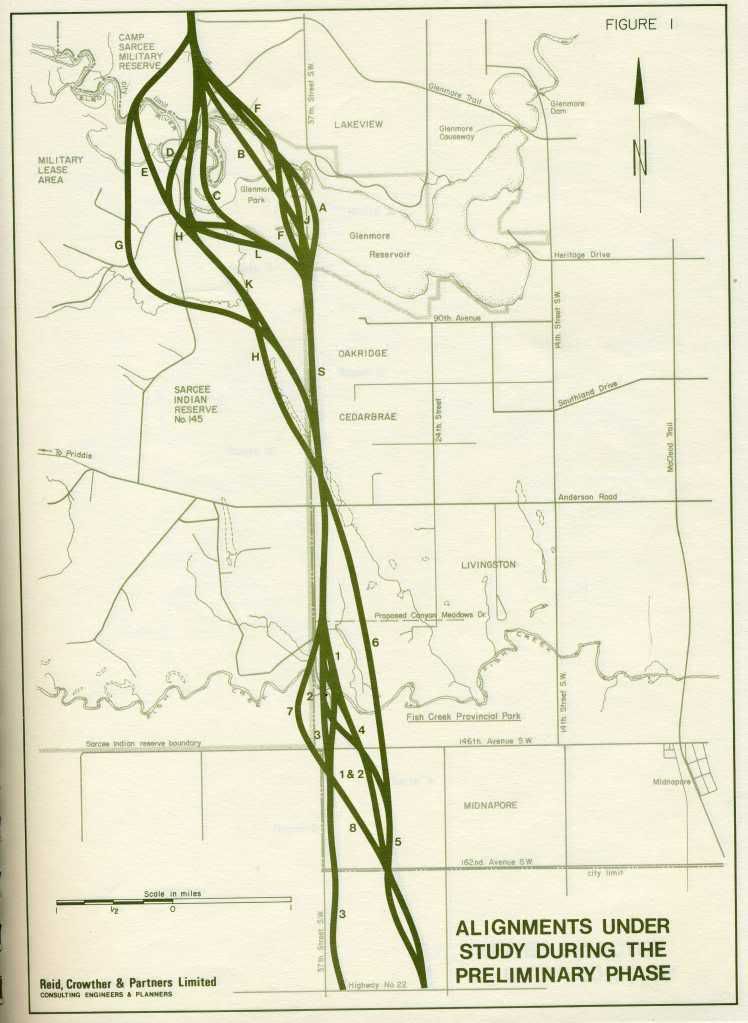
And this is a study of the SW Ring Road in 1977, with 12 alignments options through the Tsuu T'ina lands:


If anyone has any other historical maps, I would love to see them, as I hope others would too.
Reply With Quote
     
     
  #2  
Old Posted May 26, 2011, 8:24 PM
freeweed's Avatar
freeweed freeweed is offline
Home of Hyperchange
 
Join Date: Sep 2006
Location: Dynamic City, Alberta
Posts: 17,566
Much of this has been posted here before, but THIS!

Quote:
Originally Posted by 5seconds View Post
Reply With Quote
     
     
  #3  
Old Posted May 26, 2011, 8:32 PM
5seconds 5seconds is offline
Closed account
 
Join Date: Mar 2011
Posts: 935
Quote:
Originally Posted by freeweed View Post
Much of this has been posted here before, but THIS!
I know, but they were in lots of different places, so I thought it might make a better resource by having it all in one place, and putting a call out for people who have interesting historical images and maps of Calgary.

If you like that image (!) there is lots more in that linked archive
Reply With Quote
     
     
  #4  
Old Posted May 27, 2011, 4:36 AM
GoflamesGo's Avatar
GoflamesGo GoflamesGo is offline
REALTOR
 
Join Date: Feb 2006
Location: Calgary
Posts: 726
I love the conceptual plan from 1913. not including the highway through downtown.
Reply With Quote
     
     
  #5  
Old Posted May 27, 2011, 2:34 PM
Calgarian's Avatar
Calgarian Calgarian is offline
Registered User
 
Join Date: Jun 2006
Location: Calgary, AB
Posts: 24,072
The Mawson plans for Calgary were pretty bold, it's really too bad they didn't happen. I wonder what this city would have been like if they followed those.
__________________
Git'er done!
Reply With Quote
     
     
  #6  
Old Posted May 27, 2011, 7:54 PM
Dado's Avatar
Dado Dado is offline
National Capital Region
 
Join Date: Jul 2007
Location: Ottawa, Canada
Posts: 2,521
Quote:
Originally Posted by Calgarian View Post
The Mawson plans for Calgary were pretty bold, it's really too bad they didn't happen. I wonder what this city would have been like if they followed those.
The North-Central LRT line debate would be a lot different, for one...


All those grid-breaking diagonal roads would make LRT building a lot easier.
__________________
Ottawa's quasi-official motto: "It can't be done"
Ottawa's quasi-official ethos: "We have a process to follow"
Reply With Quote
     
     
  #7  
Old Posted May 27, 2011, 11:10 PM
Ferreth Ferreth is offline
IMHO
 
Join Date: Apr 2009
Location: Calgary
Posts: 882
National Archives has a lot of good stuff

I got curious and revisited the national archives to see if they had anymore good material. Some of my original collection is from there, I've posted the interesting maps below; along with some new ones I found online.

Here's a pdf from the National Archives showing a compilation by Harrison and Ponton in 1911 of current and future development planned for Calgary at the time. Interesting to see what was kept, moved and never made it in terms of district names. Also of interest you may miss, the thick dash-dot black lines show current and proposed street car lines of the day. Certainly shows an optimism about growth that would not bee seen again until the post WWII oil booms.

Here'sanother pdf, date unknown, but I would estimate early 30's based on the city border of the day and Glenmore dam listing which was completed in 1933. This map also shows a lot of streets that never would be built in the manner listed.

Lastly, here's an earlier image, the earliest thing I can find from 1883 showing the plan for tsp 24, rng 1 W5, as per the description Wish they had a bigger version of this one that I could read!
__________________
---
My Flickr account
My Ratsofrass blog
Reply With Quote
     
     
  #8  
Old Posted May 27, 2011, 11:23 PM
DizzyEdge's Avatar
DizzyEdge DizzyEdge is offline
My Spoon Is Too Big
 
Join Date: Oct 2006
Location: Calgary
Posts: 9,191
Quote:
Originally Posted by Ferreth View Post

Here's a pdf from the National Archives showing a compilation by Harrison and Ponton in 1911 of current and future development planned for Calgary at the time. Interesting to see what was kept, moved and never made it in terms of district names. Also of interest you may miss, the thick dash-dot black lines show current and proposed street car lines of the day. Certainly shows an optimism about growth that would not bee seen again until the post WWII oil booms.
The best is The Bronx
__________________
Concerned about protecting Calgary's built heritage?
www.CalgaryHeritage.org
News - Heritage Watch - Forums
Reply With Quote
     
     
  #9  
Old Posted May 28, 2011, 4:26 PM
5seconds 5seconds is offline
Closed account
 
Join Date: Mar 2011
Posts: 935
Quote:
Originally Posted by Ferreth View Post
I got curious and revisited the national archives to see if they had anymore good material. Some of my original collection is from there, I've posted the interesting maps below; along with some new ones I found online.

Here's a pdf from the National Archives showing a compilation by Harrison and Ponton in 1911 of current and future development planned for Calgary at the time. Interesting to see what was kept, moved and never made it in terms of district names. Also of interest you may miss, the thick dash-dot black lines show current and proposed street car lines of the day. Certainly shows an optimism about growth that would not bee seen again until the post WWII oil booms.

Here'sanother pdf, date unknown, but I would estimate early 30's based on the city border of the day and Glenmore dam listing which was completed in 1933. This map also shows a lot of streets that never would be built in the manner listed.

Lastly, here's an earlier image, the earliest thing I can find from 1883 showing the plan for tsp 24, rng 1 W5, as per the description Wish they had a bigger version of this one that I could read!
Those are awesome, thanks for sharing!
Reply With Quote
     
     
  #10  
Old Posted May 29, 2011, 5:07 AM
Dado's Avatar
Dado Dado is offline
National Capital Region
 
Join Date: Jul 2007
Location: Ottawa, Canada
Posts: 2,521
Quote:
Originally Posted by Ferreth View Post
Wish they had a bigger version of this one that I could read!
My attempt at the description follows the image.


During the summer of 1883, while the CPR tracks were being laid near Calgary, the area was surveyed for the Dominion government by C. E. Lorne. Settlers at that time included [can't make it out - too many names, not enough context]. At the confluence of the rivers where the NWMP fort and Hudson's Bay Co. post, while up the Elbow was the R.C. mission. In the winter of 1883-84 squatters established a tent[?] town on the east[?] side of the Elbow along the railway tracks but in the spring of 1884 the CPR laid out the official town of Calgary on Section 15.
__________________
Ottawa's quasi-official motto: "It can't be done"
Ottawa's quasi-official ethos: "We have a process to follow"
Reply With Quote
     
     
  #11  
Old Posted May 29, 2011, 5:23 PM
DizzyEdge's Avatar
DizzyEdge DizzyEdge is offline
My Spoon Is Too Big
 
Join Date: Oct 2006
Location: Calgary
Posts: 9,191
Quote:
Originally Posted by Dado View Post
My attempt at the description follows the image.


During the summer of 1883, while the CPR tracks were being laid near Calgary, the area was surveyed for the Dominion government by C. E. Lorne. Settlers at that time included [can't make it out - too many names, not enough context]. At the confluence of the rivers where the NWMP fort and Hudson's Bay Co. post, while up the Elbow was the R.C. mission. In the winter of 1883-84 squatters established a tent[?] town on the east[?] side of the Elbow along the railway tracks but in the spring of 1884 the CPR laid out the official town of Calgary on Section 15.
said 'tent town', ie what is now the main portion of Inglewood

__________________
Concerned about protecting Calgary's built heritage?
www.CalgaryHeritage.org
News - Heritage Watch - Forums
Reply With Quote
     
     
  #12  
Old Posted May 29, 2011, 7:25 PM
sim sim is offline
Registered User
 
Join Date: Aug 2008
Posts: 863
Quote:
Originally Posted by 5seconds View Post

With a stunning collection of drawings and photographs here
http://caa.ucalgary.ca/mawson Including this rendering of the approach to Prince's Island (Yes, this IS Calgary!):


You can also see this right on Prince's Island on one of those little information signs they have. I think a further 3 or 4 other options of what the island could or might have been are there as well.
Reply With Quote
     
     
  #13  
Old Posted May 29, 2011, 9:46 PM
albertantraingeek's Avatar
albertantraingeek albertantraingeek is offline
Getting sick of the NCF
 
Join Date: Feb 2011
Location: NW Calgary
Posts: 153
Here is one of 1917:

http://railways.library.ualberta.ca/Maps-8-1-6/

There are lots of mape on this site, so look around.
Reply With Quote
     
     
  #14  
Old Posted May 30, 2011, 4:27 PM
kw5150's Avatar
kw5150 kw5150 is offline
Here and There
 
Join Date: Nov 2009
Location: Calgary
Posts: 5,807
Quote:
Originally Posted by Dado View Post
My attempt at the description follows the image.


During the summer of 1883, while the CPR tracks were being laid near Calgary, the area was surveyed for the Dominion government by C. E. Lorne. Settlers at that time included [can't make it out - too many names, not enough context]. At the confluence of the rivers where the NWMP fort and Hudson's Bay Co. post, while up the Elbow was the R.C. mission. In the winter of 1883-84 squatters established a tent[?] town on the east[?] side of the Elbow along the railway tracks but in the spring of 1884 the CPR laid out the official town of Calgary on Section 15.
And from there it was an instant success.
__________________
Renfrew, Calgary, Alberta.
Reply With Quote
     
     
  #15  
Old Posted May 30, 2011, 5:13 PM
5seconds 5seconds is offline
Closed account
 
Join Date: Mar 2011
Posts: 935
Quote:
Originally Posted by albertantraingeek View Post
Here is one of 1917:

http://railways.library.ualberta.ca/Maps-8-1-6/

There are lots of mape on this site, so look around.
I had no idea that the Talisman Centre sits on an old rail-yard, or that there was a train station on 17th avenue an 1st street! Thanks for that map.
Reply With Quote
     
     
  #16  
Old Posted May 30, 2011, 7:02 PM
93JC 93JC is offline
Registered User
 
Join Date: Jul 2006
Posts: 932
Quote:
Originally Posted by 5seconds View Post
I had no idea that the Talisman Centre sits on an old rail-yard, or that there was a train station on 17th avenue an 1st street! Thanks for that map.
The train station is now the "Nat Christie Centre", home of the Alberta Ballet. As far as I know the building still has "CN Station" on it somewhere.
Reply With Quote
     
     
  #17  
Old Posted May 30, 2011, 9:49 PM
Surrealplaces's Avatar
Surrealplaces Surrealplaces is offline
Editor
 
Join Date: Feb 2006
Location: Cowtropolis
Posts: 19,968
Quote:
Originally Posted by 93JC View Post
The train station is now the "Nat Christie Centre", home of the Alberta Ballet. As far as I know the building still has "CN Station" on it somewhere.
IIRC, there is some part of the sandstone building that has 'Canadian National Railway' engraved in it.
Reply With Quote
     
     
  #18  
Old Posted May 30, 2011, 10:05 PM
5seconds 5seconds is offline
Closed account
 
Join Date: Mar 2011
Posts: 935
Quote:
Originally Posted by 93JC View Post
The train station is now the "Nat Christie Centre", home of the Alberta Ballet. As far as I know the building still has "CN Station" on it somewhere.
It's funny, that 1917 map shows the station on 17th, but the Alberta Ballet building is on 18th, and the block seems too short for a passenger train. I wonder if there was a larger/extended station that at one point fronted 17th ave?

Edit: Nope: http://ww2.glenbow.org/search/archiv...ResultsDetails

Nice building, and that explains the over-built bridge that connects that area with the Talisman Centre.

Thanks for the info!

DOUBLE EDIT: Thanks Dizzy Edge. I couldn't find those images in the archive. I am consistantly surprised by this city, and I love it's history.
Reply With Quote
     
     
  #19  
Old Posted May 30, 2011, 10:09 PM
DizzyEdge's Avatar
DizzyEdge DizzyEdge is offline
My Spoon Is Too Big
 
Join Date: Oct 2006
Location: Calgary
Posts: 9,191
^^

St Mary's Hall before purchase by the CNR


View from "Lindsay Park" area after conversion:


View from 18th ave:


Last train in 1979


Today the station platform still remains attached to the building, as well as some strips of rail embedded in the pathway.
__________________
Concerned about protecting Calgary's built heritage?
www.CalgaryHeritage.org
News - Heritage Watch - Forums
Reply With Quote
     
     
  #20  
Old Posted Oct 12, 2011, 8:44 AM
armorand93's Avatar
armorand93 armorand93 is offline
Transit Nerd
 
Join Date: Nov 2010
Location: Calgary (former Winnipegger)
Posts: 2,707
Does anyone have maps of Calgary ranging from 1978 to 1993?
Reply With Quote
     
     
This discussion thread continues

Use the page links to the lower-right to go to the next page for additional posts
 
 
Reply

Go Back   SkyscraperPage Forum > Regional Sections > Canada > Alberta & British Columbia > Calgary > Calgary Area Photos & Videos
Forum Jump


Forum Jump


All times are GMT. The time now is 3:46 AM.

     
SkyscraperPage.com - Archive - Privacy Statement - Top

Powered by vBulletin® Version 3.8.7
Copyright ©2000 - 2024, vBulletin Solutions, Inc.