HomeDiagramsDatabaseMapsForum About
     

Go Back   SkyscraperPage Forum > Regional Sections > Canada


Reply

 
Thread Tools Display Modes
     
     
  #161  
Old Posted Mar 22, 2018, 3:30 PM
Denscity Denscity is offline
Registered User
 
Join Date: Jun 2008
Location: Within the Cordillera
Posts: 12,493
Quote:
Originally Posted by JHikka View Post
Waiting anxiously for the four page conversation about how Ontarians are basically American.

Although I will say I was in St. Catharines and saw some American spellings for things (Center, Color...). This isn't uncommon in border towns/areas.
Which is hilarious because the popular band City and Colour are from St Catherine's Ontario haha!
__________________
Castlegar BC: SSP's hottest city (43.9C)
Lytton BC: Canada’s hottest city (49.6C)
Reply With Quote
     
     
  #162  
Old Posted Mar 22, 2018, 4:12 PM
MolsonExport's Avatar
MolsonExport MolsonExport is offline
The Vomit Bag.
 
Join Date: Oct 2003
Location: Otisburgh
Posts: 44,903


cbc
__________________
The whole problem with the world is that fools and fanatics are always so certain of themselves, and wiser people so full of doubts. (Bertrand Russell)
Reply With Quote
     
     
  #163  
Old Posted Mar 22, 2018, 4:14 PM
MolsonExport's Avatar
MolsonExport MolsonExport is offline
The Vomit Bag.
 
Join Date: Oct 2003
Location: Otisburgh
Posts: 44,903
Quote:
In 2016, the CMA of Toronto was the urban centre with the largest share of dwellings in high-rise buildings. In that CMA, nearly 3 in 10 dwellings were in buildings of this size. London was second on this list, with 16.8% of dwellings in buildings that have five or more storeys, followed by Vancouver, with 16.7%.
http://www12.statcan.gc.ca/census-re...016005-eng.cfm
__________________
The whole problem with the world is that fools and fanatics are always so certain of themselves, and wiser people so full of doubts. (Bertrand Russell)
Reply With Quote
     
     
  #164  
Old Posted Mar 22, 2018, 6:01 PM
lio45 lio45 is offline
Moderator
 
Join Date: Aug 2007
Location: Quebec
Posts: 42,191
Quote:
Originally Posted by MonctonRad View Post
from CBC

http://www.cbc.ca/news/technology/wa...ught-1.4570333


Interesting that there might be a prairie forming up the entire McKenzie River valley.......
I wonder where the tree line would be in such a scenario. (Just plain curiosity, not rooting for it.)
Reply With Quote
     
     
  #165  
Old Posted Mar 22, 2018, 6:08 PM
megadude megadude is online now
Registered User
 
Join Date: Sep 2017
Location: N. York/Bram/Mark/Sauga/Burl/Oak/DT
Posts: 3,059
I like to fish by boat. When I'm lazy I tend to troll with different lures while I'm putting along the river or lake. It was this combination of sport fishing and laziness that spurred my interest in routes that connect different bodies of water.

If I were super rich, I'd hire a captain to guide a house boat on the following routes while I chill on the stern of the boat with a fishing rod in the rod holder and a beer in the cup holder... just waiting for the next fish to hit, all while taking in the sights of different towns and landscapes along the way.

Not many people do these routes as it's very time consuming, but my retired boss did do the Trent Severn last year when his friend bought a sail boat in Penetang and took it from the harbour there out to Trenton and then west to Whitby (next to Oshawa). Looked very cool after seeing all the pics.

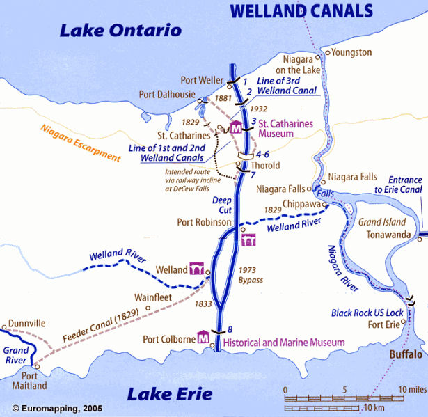
Just going through all the man made locks and canals would be pretty cool to see. And the marine rail at Big Chute in Muskoka is awesome to watch in action:


https://www.tripadvisor.ca/LocationP...t_Ontario.html


Being stopped by a cargo ship at a lock or lift bridge or what have you is a massive inconvenience, but it is interesting to watch when a big ass tanker passes by, whether it's on the Welland Canal, St. Lawrence Seaway, Rideau Canal or Soo Locks to name a few.

It's pretty awesome that you can travel so far inland or near land by boat. BC has lots of opportunities, not just on the coast, but up the Frasier. Seen lots of fishing shows take place there.

Same with east coast.

Not sure how navigable rivers like the Saskatchewan, Bow, Assiniboine, Red or Ottawa are. Can definitely canoe them with portaging, but no idea how far motorized craft can go.
Reply With Quote
     
     
  #166  
Old Posted Mar 22, 2018, 6:08 PM
megadude megadude is online now
Registered User
 
Join Date: Sep 2017
Location: N. York/Bram/Mark/Sauga/Burl/Oak/DT
Posts: 3,059

Map: Steven Fick/Canadian Geographic
Reply With Quote
     
     
  #167  
Old Posted Mar 22, 2018, 6:09 PM
megadude megadude is online now
Registered User
 
Join Date: Sep 2017
Location: N. York/Bram/Mark/Sauga/Burl/Oak/DT
Posts: 3,059
Reply With Quote
     
     
  #168  
Old Posted Mar 22, 2018, 6:09 PM
MonctonRad's Avatar
MonctonRad MonctonRad is online now
Wildcats Rule!!
 
Join Date: Jun 2008
Location: Moncton NB
Posts: 34,614
Quote:
Originally Posted by lio45 View Post
I wonder where the tree line would be in such a scenario. (Just plain curiosity, not rooting for it.)
According to the CBC article, any brownish coloured area would have difficulty sustaining a forest. If you are talking about the northern tree line, I have no idea (although in a warming world would be further north than it is now).
__________________
Go 'Cats Go
Reply With Quote
     
     
  #169  
Old Posted Mar 22, 2018, 6:10 PM
megadude megadude is online now
Registered User
 
Join Date: Sep 2017
Location: N. York/Bram/Mark/Sauga/Burl/Oak/DT
Posts: 3,059

Great Lakes St. Lawrence Seaway (Map: Steven Fick/Canadian Geographic)


https://en.wikipedia.org/wiki/Saint_Lawrence_Seaway

Reply With Quote
     
     
  #170  
Old Posted Mar 22, 2018, 6:11 PM
megadude megadude is online now
Registered User
 
Join Date: Sep 2017
Location: N. York/Bram/Mark/Sauga/Burl/Oak/DT
Posts: 3,059
Reply With Quote
     
     
  #171  
Old Posted Mar 24, 2018, 3:39 PM
ainvan ainvan is offline
Registered User
 
Join Date: Jul 2007
Location: Toronto/Vancouver
Posts: 965
Reply With Quote
     
     
  #172  
Old Posted Mar 24, 2018, 3:47 PM
ainvan ainvan is offline
Registered User
 
Join Date: Jul 2007
Location: Toronto/Vancouver
Posts: 965
Reply With Quote
     
     
  #173  
Old Posted Mar 24, 2018, 5:29 PM
vid's Avatar
vid vid is offline
I am a typical
 
Join Date: Apr 2004
Location: Thunder Bay
Posts: 41,172
Separate Northern Ontario, and our region has Italian as a third language. If you include Ojibwe and Cree as the same language though, that's in third place. They're in fourth and fifth if you keep them separate. They will surely overtake Italian in the coming decades.
Reply With Quote
     
     
  #174  
Old Posted Apr 1, 2018, 12:15 AM
MonctonRad's Avatar
MonctonRad MonctonRad is online now
Wildcats Rule!!
 
Join Date: Jun 2008
Location: Moncton NB
Posts: 34,614
What North America would have looked like if the Annexation Act of 1866 had passed the US Congress


https://en.wikipedia.org/wiki/Annexation_Bill_of_1866

Quote:
The bill would have authorized the President of the United States to, subject to the agreement of the governments of the British provinces:

“publish by proclamation that, from the date thereof, the States of Nova Scotia, New Brunswick, Canada East, and Canada West, and the Territories of Selkirk, Saskatchewan, and Columbia, with limits and rights as by the act defined, are constituted and admitted as States and Territories of the United States of America.”
Quote:
Several financial incentives were offered to the British Colonies to help get them on board including:

Purchase of the Hudson’s Bay Company’s lands for $10,000,000.
Take over provincial debts which amounted to $85,700,000.
Give an annual subsidy of $1,646,000 to the new states.
Connect Canada with the Maritimes by rail and spend $50,000,000 to complete and improve the colonial canal system.
Quote:
If the bill had passed, it would have added 4 new states and 3 new territories to the United States.

States:

- New Brunswick: Modern-day New Brunswick
- Nova Scotia: Modern-day Nova Scotia and Prince Edward Island
- Canada East: Modern-day Quebec and Newfoundland and Labrador
- Canada West: Modern-day Ontario excluding part of NW Ontario.

Territories:

- Selkirk Territory: Modern-day Manitoba, and parts of modern-day northwestern Ontario, Nunavut, Saskatchewan and the Northwest Territories
- Saskatchewan Territory: Modern-day Alberta, and parts of modern-day Saskatchewan, British Columbia, the Northwest Territories and Yukon.
- Columbia Territory: The part of modern-day British Columbia west of the Rocky Mountains.
Quote:
The Annexation Bill of 1866 was introduced by Massachusetts Congressman Nathaniel Prentice Banks and was intended to appeal to Irish Americans who supported the Fenian Movement, which was extremely hostile to Britain.
The Fenian Raids on Canada, this particular bill, and the presence of 600,000 battle hardened Union Army veterans (3x the size of the entire British Army) all proved to be strong incentives to completing the process towards Canadian Confederation during the London Conference of 1866, into 1867.
__________________
Go 'Cats Go
Reply With Quote
     
     
  #175  
Old Posted Apr 1, 2018, 5:39 AM
lio45 lio45 is offline
Moderator
 
Join Date: Aug 2007
Location: Quebec
Posts: 42,191
Quote:
Originally Posted by MonctonRad View Post
States:

- Canada East: Modern-day Quebec and Newfoundland and Labrador
At least there wouldn't have been any argument over the territory of Labrador under this plan
Reply With Quote
     
     
  #176  
Old Posted Apr 1, 2018, 5:09 PM
GlassCity's Avatar
GlassCity GlassCity is offline
Rational urbanist
 
Join Date: Aug 2012
Location: Metro Vancouver
Posts: 5,267
Quote:
Originally Posted by lio45 View Post
At least there wouldn't have been any argument over the territory of Labrador under this plan
Speaking of which, you know how Google Maps shows different boundaries in different places? As in Crimea is shown as part of Ukraine from a Ukrainian computer and as part of Russia from a Russia computer. Does that exist in Quebec? Is the southern Labrador boundary any different?
Reply With Quote
     
     
  #177  
Old Posted Apr 1, 2018, 5:21 PM
Acajack's Avatar
Acajack Acajack is online now
Unapologetic Occidental
 
Join Date: Aug 2006
Location: Province 2, Canadian Empire
Posts: 68,143
Nope. The border I see on Google Maps is the 1927 Privy Council line.
__________________
The Last Word.
Reply With Quote
     
     
  #178  
Old Posted Apr 1, 2018, 5:42 PM
vid's Avatar
vid vid is offline
I am a typical
 
Join Date: Apr 2004
Location: Thunder Bay
Posts: 41,172
They mostly only do that if it's between two countries, not within a country.
Reply With Quote
     
     
  #179  
Old Posted Apr 1, 2018, 5:45 PM
GlassCity's Avatar
GlassCity GlassCity is offline
Rational urbanist
 
Join Date: Aug 2012
Location: Metro Vancouver
Posts: 5,267
Quote:
Originally Posted by vid View Post
They mostly only do that if it's between two countries, not within a country.
Makes sense, but I was just curious. I think most Canadians probably don't even know there's a dispute there.
Reply With Quote
     
     
  #180  
Old Posted Apr 1, 2018, 6:21 PM
ainvan ainvan is offline
Registered User
 
Join Date: Jul 2007
Location: Toronto/Vancouver
Posts: 965
Reply With Quote
     
     
This discussion thread continues

Use the page links to the lower-right to go to the next page for additional posts
 
 
Reply

Go Back   SkyscraperPage Forum > Regional Sections > Canada
Forum Jump


Forum Jump


All times are GMT. The time now is 1:13 AM.

     
SkyscraperPage.com - Archive - Privacy Statement - Top

Powered by vBulletin® Version 3.8.7
Copyright ©2000 - 2024, vBulletin Solutions, Inc.