Quote:
Originally Posted by dc_denizen

Who care about MSA. What matters is urban area.
New Yorks urban area contains 19 million people. London, around 12 million.
This is based on contiguous built up urban areas above a certain density threshold, not commute share to far flung rural areas.
|
Why do either matter if the connectivity to the city at the heart of these agglomerations is constricted or convoluted to make worthwhile interaction limited? Close to one million people live in Bergen County, but there isn’t a direct rail service to New York City. Urban and metro area counts are a barometer of unchecked urban sprawl rather than providing qualitative measurement of activity between a city and the surrounding environment.
Only slightly more people commute into Manhattan from outside of New York City, than those that commute into Central London from outside London. It is conceivable that in the near future (due to faster surrounding population growth and higher investment in high-capacity rail infrastructure) that London could surpass New York on this measure.
Quote:
Originally Posted by dc_denizen
Really? which suburbs? England has what, 1000 people per square mile. I'm not sure you're familiar with NYC's suburbs.
|
In answer to your specific question, the counties of Dutchess, Hunterdon, Leigh, Morris, Northampton, Ocean, Orange, Pike, Putnam and Sussex in New York’s MSA have a population density below that of England.
I don’t really understand the confusion some people are having. After WW2, London enacted the Green Belt to prevent rampant urban sprawl. New York and other cities didn’t. As a consequence, urban and commuter catchment development beyond London materialised along different lines.
Quote:
Originally Posted by dc_denizen
in the UK, it's sprawl separated by farms that peters out into rural areas.
|
The Green Belt focused – what would have undoubtedly become rampant sprawl development in the absence of the Green Belt – into enlarging and densifying new towns, garden cities, market towns, etc… that orbit London. Rural areas are the preserved space between these settlements, which was the entire point of the Green Belt. Even on non-Green Belt land, the idea of rampant sprawl is politically toxic.
Quote:
Originally Posted by dc_denizen
Also, hasn't greater london basically just now recovered in population to 1950's level of around 10 million? While New Yorks urban area has gone from 10 million to 18 million?
|
(Greater) London’s previous population peak was in 1939 at 8.6mn. After the war, government policy was focused on decentralisation and rehousing residents of Blitz destroyed neighbourhoods outside London, hence the new towns of Crawley, Harlow, Stevenage, Basildon, Slough, etc... The South East of England and East of England (the two regions surrounding London) subsequently experienced sizable population growth but starting in the 1980’s London’s population began to recover, and its growth has been accelerating ever since.
In 2015 London surpassed its pre-1939 peak. In 2016 the population stood at 8.8mn, and as of this moment it has probably surpassed 9mn.
London is currently growing by 123,000 p.a., compared to 78,000 p.a. and 57,000 p.a. for the South East of England and East of England respectively. The New York MSA and CSA are respectively growing by 77,000 p.a. and 82,000 for comparison.
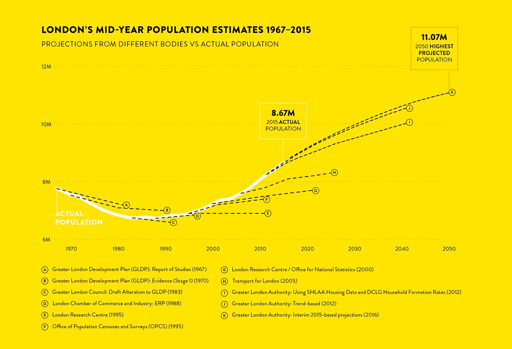 Image sourced from Centre for London: http://essays.centreforlondon.org/is...on-projections


 Prev
Prev


 Linear Mode
