Quote:
Originally Posted by gratiotfaced

I honestly wasn't sure the city would see any growth this decade, but definitely didn't expect so soon into it.
Even then, I assumed any growth at all would be a marginal +50 or +175 kind of number, not almost +2,000!
Even then, I would never have expected Detroit to climb population rankings, let alone jump up several spots!
This is probably the biggest and best headline for the city since emerging from bankruptcy, maybe longer. Detroit has never grown in my lifetime or my parents' lifetimes. It's hard to overstate how significant and monumental this is.
The turnaround for this city and the speed at which it has happened honestly makes me a little misty eyed, lol. This headline was unimaginable ten years ago. So proud of Detroit. I hope to see a future where Detroit is so vibrant and thriving that people are shocked to learn the city used to be so troubled and empty, though I know that's many decades away.
|
It’s certainly a huge milestone to celebrate the narrative has always been Detroits comeback isn’t real until the population starts growing. Well hot damn it is. The affordability of nice homes in a city that has a SIGNIFICANTLY lower violent crime rate. Detroits homicide rate is on par with DC it’s in the 30’s per 100k which isn’t good but as in all cities there are crime hot spots and safe areas.
Considering we’ve seen a 27% drop at the same time last year we saw the only uptick it’s looking increasingly likely violent crime is going to set another record low. Along with new significant infrastructure projects that will continue to improve the city alongside its economy & quality of life certainly pushes the needle in the right direction.
*One of the best infrastructure projects the city is investing in is its water and sewerage system, the state deal with Highland Park and other major projects to keep raw sewage out of basements is a huge step forward that is being overlooked. The city was designed for a different era when an inch of rain was as about as heavy as you would see in a single storm but global warming has increased rainfall. I’m happy to see that it’s a regional project as well with Oakland & Macomb paying their fair share. Lead line replacement & lead clean up have been active as well as an initiative to clean up groundwater from brownfield sites and facilities operating since before the clean air and water act.
Quote:
DBUSINESS
Great Lakes Water Authority Unveils 40-year Wastewater Plan
The Great Lakes Water Authority board of directors has adopted a regional Wastewater Master Plan to manage the wastewater system that serves 2.8 million people and spans 15,000 miles of pipes across 79 communities in southeast Michigan.
By Grace Turner -December 11, 2020
|

Quote:
In southeast Michigan, wastewater, which includes sanitary and some stormwater, flows throughout 86 separate municipal systems connected to the authority. It is treated at the authority’s Water Resource Recovery Facility, the largest single-site wastewater treatment facility in North America.
Implementation of the plan will occur in three phases: optimizing, adapting and expanding, and sustaining.
Key phase one initiatives, many of which are underway, work to stretch the region’s money by prioritizing investment in lower cost, high-impact projects with the greatest environmental benefit to the system. They include:
Launch of a regional operating plan, in which operators from the authority and its member communities use real-time computer technology to see areas where, during intense rainfall and snow melts, there is too much flow in the system and move it to areas with more capacity, reducing the risk of overflows and backups across the region without expensive new infrastructure;
Expansion of connectors to the Detroit River Interceptor, a large, deep sewer that collects or intercepts flow from smaller, shallower sewers. This would cost $15 million and redirect 160 million gallons of wastewater to the Water Resource Recovery Facility, preventing it from being discharged untreated into the Detroit River;
Formation of a Regional Watershed Hub Workgroup that is bringing the region’s watershed advocacy organizations together with the authority and its member partners to develop a Regional Water Quality Monitoring Program. The program will collect real-time data on water quality in the Rouge, Clinton, and Detroit rivers and Lake St. Clair. The data will be used to determine where system maintenance and upgrades are needed to improve water quality and allow for healthy recreation in rivers and lakes; and
Partnership with the Michigan Department of Transportation and the Detroit Water and Sewerage Department on projects to either remove freeway drainage from the combined sewer system or treat the flow before it is directed to the Detroit River. The most noteworthy collaborations are with the I-94 and I-375 improvement projects, and on the proposed Gordie Howe International Bridge.
“By working together as outlined in the WWMP, we will maintain reliable, high quality service while protecting our natural resources for residents and visitors to the region to enjoy,” says Suzanne Coffey, chief planning officer, for the authority. “Everyone – our member partners and community leaders, no matter how large or small their community is – has a role they can play and a shared responsibility to support and help with the execution. We view this as a truly collaborative and proactive effort to look, find, and fix issues before they become problems.”
The results will be assessed in five-year intervals, with the plan updated and adapted based on progress achieved.
|
https://www.dbusiness.com/daily-news...stewater-plan/
An interesting case study I hope it gets implemented here in the city on a larger scale.
The Alpena area is currently the focus as PFAS from the NORAD / SAC Air Base has infiltrated the ground water surrounding the closed military facility outside of town. The sinkholes in the limestone rich area in Lake Huron are proving this case study that out ground water effects our lake water more than in just rivers.
A lot of pre clean air/water brownfield sites and some facilities still operate (while in compliance) the ground has certainly been affected.
Quote:
Modeling Shallow Urban Groundwater at Regional and Local Scales: A Case Study in Detroit, MI
by Sadaf Teimoori, Brendan F. O’Leary and Carol J. Miller
Department of Civil and Environmental Engineering, College of Engineering, Wayne State University
|

Hypothetical scheme of hydrogeological cycle in the Detroit region.
Quote:
|
Groundwater serves a vital role in supplying drinking water and providing essential services such as cooling water for power generation, irrigation water for farms and landscapes, and industrial water in the Great Lakes Basin (GLB). Groundwater quality issues can lead to environmental and human health problems and can challenge environmental management. Groundwater exists in hidden natural reservoirs (aquifers) that gradually deliver water to many other surface water resources such as lakes, streams, and wetlands. Due to groundwater’s slow transport rates and the lack of a visible interface, there is often a tremendous lag between a contamination incident and the recognition of a problem [1]. To that end, protecting and remediating groundwater is often far more complex and costly than the same efforts for surface water bodies [2,3,4]. Regulatory efforts on groundwater primarily focus on contamination from hazardous chemicals and typically rely on a site-by-site approach. The high financial cost and piecemeal approach to groundwater remediation has led to a research gap in understanding of urban groundwater movement in cities that rely on surface water in the GLB [5]. This study reviews known and expanding information about groundwater resources in the Detroit metro region, the principal urban area in Michigan, as well as one of the largest in the GLB. In this region, groundwater is recharged almost entirely from rainfall and snowmelt that infiltrates down to the water table.
|

Figure 2. Interpolated surficial deposits cross-section of metropolitan Detroit
…..
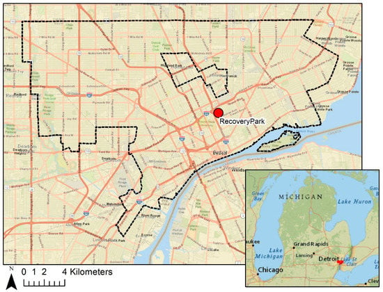
Figure 3. Location map for RecoveryPark. City of Detroit boundaries are shown by the dashed lines, and RecoveryPark location is shown by the red dot.
Quote:
Historical hydrogeological studies relied on water well logs and surficial and bedrock geologic maps. These studies were primarily conducted for groundwater exploitation and did not typically address near-surface aquifers because they were not generally considered potential potable water sources. Leverett [33] conducted the first detailed study of the groundwater resources of southeastern Michigan. Leverett’s study was prompted by a potential shortage of available groundwater resources in the central and eastern portions of Wayne County. Hydrogeologic studies of southeastern Michigan rely primarily on water well logs. The reliability of these water well logs is limited by the lack of uniformity among drillers, absence of detailed subsurface lithologic descriptions, and insufficient geographic distribution of wells. The stratigraphic correlation of near-surface sediments in southeastern Michigan is complicated because of the complex nature of sedimentation by both ice and water [34]. Groundwater flows toward the surface water within the sand units, and if present, is generally found at a depth ranging from ~one to three meters from the land surface [6,31]. However, in Metro Detroit, the perched or discontinuous groundwater is usually encountered in the upper one meter due to the predominant underlying clay unit. Mozola [30] suggested that the source of groundwater recharge for sand, gravel, and coble layer may be the Defiance Moraine; however, this has not been confirmed. Howard [32] presented a surficial geologic map of the Detroit quadrangle, which can serve as a framework for assessing and redeveloping future urban sites. The final maps, including stratigraphic sections and soil layers across Metro Detroit, are useful for expanded studies on groundwater and the vadose zone beneath this region.
2.1.2. Local Scale: RecoveryPark Field Site
RecoveryPark is a nonprofit urban farm in the Poletown neighborhood of Detroit that provides local agricultural employment for residents [35] (Figure 3). While RecoveryPark is located in an urban neighborhood, a majority of the lots are cleared of debris and vacant. Apart from the existing or historic utility infrastructure and building basements, no other major subsurface features are present.
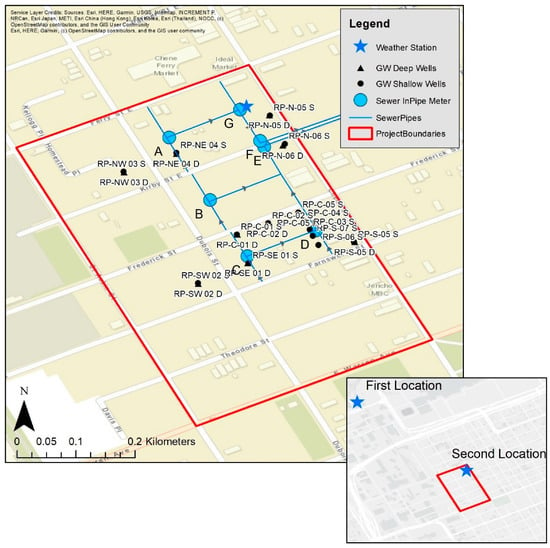
Site map at RecoveryPark with shallow wells, deeper wells, sewer in-pipe meter locations, and weather station. Wells start with RP, and in-pipe sewer meters are alphabetically labeled.
The United States Geological Survey (USGS) and the United States Environmental Protection Agency (USEPA) collaborated to study the effectiveness of green stormwater infrastructure (GSI) at this site since 2014. A water cycle monitoring approach was used to assess the role of GSI in a larger hydrologic context. The property includes a weather station and the only publicly available groundwater wells in the city of Detroit. The weather station was initially located north of the study (first location: 2014 to 2017) and then was moved to its current onsite location during fall 2017 (second location: 2017 to present). Soil boring data and in-pipe flow meter data from the site are available from the Detroit Water and Sewage Department (DWSD). Overall, there are 23 groundwater wells and seven in-pipe sewer meters spread over a 1.686×10⁻¹ km2 area (Figure 4). The onsite sewer lines appearing in Figure 4 transported only local sewage (no off-site areas contributed), and the sewer output all flowed through meters E and F before exiting the study boundaries. Soil moisture sensors were added to the field equipment in 2017 and are located near the weather station.

RecoveryPark is a unique urban study area in that it includes one of the only urban well fields in the Great Lakes Basin [36]. The insights gleaned from this location offer a detailed understanding of one localized neighborhood but still does not remedy the larger regional knowledge gap. The lack of publicly available urban well data presents issues for groundwater mapping both at the regional and local scales. This problem is not unique to the metropolitan Detroit region. Most major cities in the United States lack open-source groundwater field data.
|
https://www.mdpi.com/2073-4441/13/11...water-13-01515
I believe this is the previous clean water program/study which would make the recovery park study and implementation the 3rd major clean water initiative in the region since the 90’s. The city’s implementation of blue water management initiatives such as on the Oakman Ave median in the Aviation Subdivision off W. Warren & the Rouge Park stormwater wetland retention system is a result of these studies.
Detroit Environmental Agenda
Environment, Land & Water Infrastructure
__________________
The staff were kind enough to let me know my problem signing in was that I had an old email on my account. I’m still a bit confused on how that happened, but them’s the breaks. Unfortunately it was several days till got the email by then I created my new account.
Last edited by Doc_Love; Yesterday at 8:18 PM.
|


 Prev
Prev


 Linear Mode
