The urban area of Paris expands further. 4.5 km² (1.7 sq. miles) of farmland is going to be urbanized on the northeastern fringe of the Paris urban area, in the commune (municipality) of Gonesse. This area is where farmland is currently the closest from the center of Paris, only 16 km (10 miles) from Notre Dame Cathedral as the crow flies. When you arrive in Paris on the motorway from Calais, Lille, and Brussels, this is the farmland you can see on the right side of the motorway past Paris-CDG Airport. The reason why this area has remained undevelopped so far is because it is stuck between Paris-CDG Airport and Paris-Le Bourget Airport, and so French authorities have frozen any development to prevent potential tensions between future residents and CDG Airport, the 2nd busiest European airport and soon-to-be busiest European airport.
I don't know if they have changed the rules, but the urbanization of 4.5 km² of farmland immediately north of Paris-Le Bourget Airport has been given the green light. This is still a good 3 km (1.8 miles) from Paris-CDG Airport, but that's the closest from CDG it has been allowed to develop land for many years.
For a bit of perspective on this: the population of Greater Paris is currently increasing by 85,000 inhabitants every year, a figure much higher than in the 1990s, and much higher than French authorities had anticipated. In Europe only Madrid has experienced a higher population increase than Paris in recent years. It is estimated that 60,000 dwellings need to be built every year in Greater Paris just to accomodate the population growth and prevent an already tense housing situation from becoming frankly dramatic. If this pace of construction is not reached (currently only 35,000 dwellings are built every year in Greater Paris, far fewer than needed), then probably Greater Paris will revert to the dramatic situation experienced in the 1930s-1950s (sky-high rents, generalized illegal subletting of crowded apartments, lots of illegal slums springing up in the suburbs, many homeless people sleeping in the street). French authorities have already seen with horror two illegal slums appearing in the suburbs of Paris in the past three years, built by poor newly-arrived immigrants. This had not been seen in Paris since the last slums were razed in the 1970s. These two slums have since been razed, but it's only a matter of time before new ones appear if the pace of housing construction doesn't accelerate.
In red the commune of Gonesse within Greater Paris. The area to be urbanized is in the southern part of the commune.

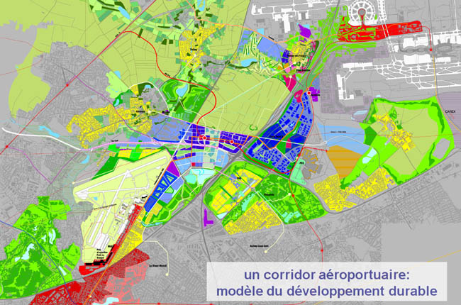
Here is a view of the winning project selected by the jury. The winning team is Swiss and Dutch (Güller & Güller: architects; DHV: economic strategies; Ernst Basler & Partner: infrastructures; Paul van Beek Landschappen: landscape architect). The jury selected the project offering the highest urban density, and the highest environmental sustainability (lots of public transportation, such as a new branch of the Paris RER serving this new urban district). The long awaited motorway between Villepinte and Saint-Gratien will apparently also be built (colored brownish-orange on the render below, running towards the upper-right corner). This motorway will run parallel to the A86 inner orbital motorway and the Francilienne outer orbital motorway, approximately half-way between the two, linking the northeastern and northwestern suburbs.
On the render below, the south is up, the north is down. The motorway heading to Lille and Belgium is on the left. The center of Paris lies 16 km (10 miles) in the distance past the upper-left corner of the render. The airport on the render is Paris-Le Bourget Airport. Paris-CDG Airport lies 1.9 km (1.2 miles) beyond the lower-left corner of the render. Compacité = compactness.


 Prev
Prev


 )
) 


 Linear Mode
