HomeDiagramsDatabaseMapsForum About
     

Go Back   SkyscraperPage Forum > Regional Sections > Canada > Ontario > Hamilton > General Discussion


Reply

 
Thread Tools Display Modes
     
     
  #21  
Old Posted Jun 10, 2013, 2:49 PM
Dr Awesomesauce's Avatar
Dr Awesomesauce Dr Awesomesauce is offline
Registered User
 
Join Date: Jan 2010
Location: BEYOND THE OUTER RIM
Posts: 5,889
Building no.4

Another interesting one here. I was blown away when I first saw a photo of this building. Again, like so many others, it was allowed to fall into disrepair and then just slipped away without a word. This isn't much of a clue but the intersection at which it stood no longer exists, nor do any of the buildings. Points for approximate location and function of the building if you're not sure what it is.

http://pinterest.com/pin/170855379584650536/
Reply With Quote
     
     
  #22  
Old Posted Jun 10, 2013, 4:30 PM
Beedok Beedok is offline
Exiled Hamiltonian Gal
 
Join Date: Jun 2012
Posts: 6,806
Was it removed to make Jackson Square?
Reply With Quote
     
     
  #23  
Old Posted Jun 10, 2013, 4:54 PM
thomax's Avatar
thomax thomax is offline
Registered User
 
Join Date: May 2012
Location: Toronto
Posts: 5,380
Royal Hotel. It was on Merrick Street before the street was realigned and renamed York Blvd, that's why the intersection no longer exists.


On The Residences of the Royal Connaught Pinterest and Facebook page, they have an interior shot of the Royal Hotel. Whoever is running the page thought that the Royal Hotel was the same hotel as the Royal Connaught hotel.
Reply With Quote
     
     
  #24  
Old Posted Jun 11, 2013, 1:27 AM
Dr Awesomesauce's Avatar
Dr Awesomesauce Dr Awesomesauce is offline
Registered User
 
Join Date: Jan 2010
Location: BEYOND THE OUTER RIM
Posts: 5,889
You're killin' it, Thomas. Nice one. I'd say only the most avid of Hamilton historians know this building. It's rarely ever mentioned in the same breath with the Connaught or the Waldorf or even the King George.

Of note, the Royal was built in 1857 for the astronomical sum of $1,000,000. It was the premier hotel in the city and likely much farther afield - I mean, just look at it! Over the years, however, it feel into disrepair and by the time it burnt to the ground in 1935 it was more of a flop-house than a 5-star hotel.

For those who are unfamiliar with the old street grid, this is roughly what it looked like:


Key:
red line = Merrick st
blue = York st
green = Market st
orange = Park st
yellow = MacNab st

Red star = the Royal Hotel
Orange star = the Arcade/ Eaton's
Darker blue = old City Hall
Lighter blue = the farmer's market
Reply With Quote
     
     
  #25  
Old Posted Jun 11, 2013, 1:45 AM
Dr Awesomesauce's Avatar
Dr Awesomesauce Dr Awesomesauce is offline
Registered User
 
Join Date: Jan 2010
Location: BEYOND THE OUTER RIM
Posts: 5,889
Here's a shot of the market ca 1893, about four years after it was built.

For some context, the buildings directly across market square are on Merrick and at the far right is the western edge of the Royal Hotel. The buildings to the left are on MacNab and the photo was taken - roughly - at the confluence of Market and York streets.

The market burned to the ground some years later (1917?) and it was said that a sea of rats could be seen fleeing the flaming structure. Awesome!


http://pinterest.com/pin/170855379584650738/
Reply With Quote
     
     
  #26  
Old Posted Jun 11, 2013, 1:54 AM
Dr Awesomesauce's Avatar
Dr Awesomesauce Dr Awesomesauce is offline
Registered User
 
Join Date: Jan 2010
Location: BEYOND THE OUTER RIM
Posts: 5,889
Building no.5

This one's still around...kinda.

http://henleyshamilton1.wordpress.com/2013/02/
Reply With Quote
     
     
  #27  
Old Posted Jun 11, 2013, 2:16 AM
thomax's Avatar
thomax thomax is offline
Registered User
 
Join Date: May 2012
Location: Toronto
Posts: 5,380
Amisfield castle. It's in behind the plaza on the corner of James and Duke Street.
Reply With Quote
     
     
  #28  
Old Posted Jun 11, 2013, 11:08 AM
Dr Awesomesauce's Avatar
Dr Awesomesauce Dr Awesomesauce is offline
Registered User
 
Join Date: Jan 2010
Location: BEYOND THE OUTER RIM
Posts: 5,889
OK Thomas, you're cut off! Just kidding. It's nice to see someone who knows their history, depressing though it may be.

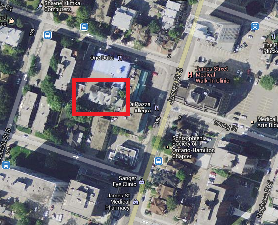
Yes, it's the Castle - Amisfield, that is. Most people have probably never noticed it before because it's almost completely obscured by the strip mall at Duke and James.


Here are a few others courtesy of Henley's Hamilton (http://henleyshamilton1.wordpress.com/2013/02/):

Notice the frontage and the massive stone wall running along James. According to Brian Henley, the City had considered buying the Castle and the property and making it the location of the Art Gallery of Hamilton. Didn't happen...


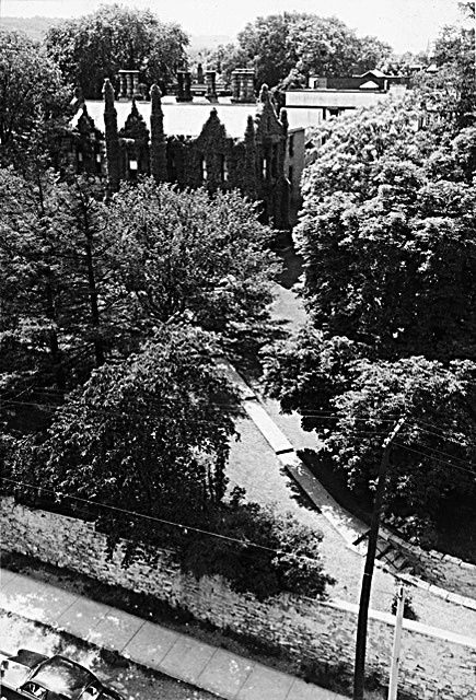
Those beautiful grounds destroyed for, you guessed it, a gas station. Are we mad?


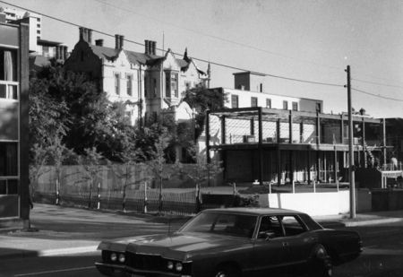
Here it is circa 1980 with the strip mall going up.

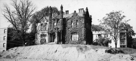
I visited the Castle years ago - maybe 15 - to view an apartment. Like so many of Hamilton's once-great estates, Amisfield was turned into a block of flats. Unlike some of the other conversions however, this one was poor. The apartments I saw were nasty - one of them looked like a crack den...whatever that is.

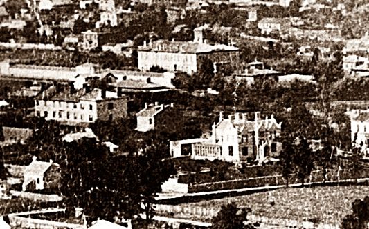
Here's one last 'aerial' (ca early 1860s) likely taken from the escarpment. Amisfield is dead-centre. There are a couple other identifiable buildings in this shot - can you name them?

Last edited by Dr Awesomesauce; Jun 11, 2013 at 11:19 AM.
Reply With Quote
     
     
  #29  
Old Posted Jun 11, 2013, 12:20 PM
mattgrande's Avatar
mattgrande mattgrande is offline
Registered User
 
Join Date: Jul 2010
Location: Hamilton
Posts: 1,240
Dammit! Amisfield Castle was the first one I noticed!
__________________
Livin' At The Corner Of Dude And Catastrophe.
Reply With Quote
     
     
  #30  
Old Posted Jun 11, 2013, 12:30 PM
Dr Awesomesauce's Avatar
Dr Awesomesauce Dr Awesomesauce is offline
Registered User
 
Join Date: Jan 2010
Location: BEYOND THE OUTER RIM
Posts: 5,889
You've gotta be quick with Thomas around. Recognise anything in the above photo?
Reply With Quote
     
     
  #31  
Old Posted Jun 11, 2013, 1:04 PM
durandy durandy is offline
Registered User
 
Join Date: Feb 2011
Posts: 620
Is that Sandyford place behind it? And to the left I believe is a coachhouse for the Castle that is now a convenience store.
Reply With Quote
     
     
  #32  
Old Posted Jun 11, 2013, 3:09 PM
Dr Awesomesauce's Avatar
Dr Awesomesauce Dr Awesomesauce is offline
Registered User
 
Join Date: Jan 2010
Location: BEYOND THE OUTER RIM
Posts: 5,889
Yep, you got it! That's definitely Sandyford Place. And that's an interesting idea about the coach house. Looking at it, you're probably right about that. The coach house has undergone some alterations over the years but, yeah, there she is.


Reply With Quote
     
     
  #33  
Old Posted Jun 12, 2013, 2:46 PM
Dr Awesomesauce's Avatar
Dr Awesomesauce Dr Awesomesauce is offline
Registered User
 
Join Date: Jan 2010
Location: BEYOND THE OUTER RIM
Posts: 5,889


The only other buildings I can positively identify are Central School (1853) which seems to have, incidentally, a massive stone wall around it. Can't quite figure that one out.

And I think the other one (purple arrow) is this building:
Reply With Quote
     
     
  #34  
Old Posted Jun 12, 2013, 2:55 PM
Dr Awesomesauce's Avatar
Dr Awesomesauce Dr Awesomesauce is offline
Registered User
 
Join Date: Jan 2010
Location: BEYOND THE OUTER RIM
Posts: 5,889
Building no.6

For this one I'm gonna need the name of the building and the approximate year the photo was taken (within a decade).

http://henleyshamilton1.wordpress.com/2012/12/
Reply With Quote
     
     
  #35  
Old Posted Jun 12, 2013, 3:34 PM
thomax's Avatar
thomax thomax is offline
Registered User
 
Join Date: May 2012
Location: Toronto
Posts: 5,380
Bank of Hamilton Building.

The picture had to be before 1905, because that is the year an 8 story addition was added.

It faced Gore Park on the SW corner of King and James.

Commerce Place now stands in it's place.
Reply With Quote
     
     
  #36  
Old Posted Jun 13, 2013, 1:11 AM
Dr Awesomesauce's Avatar
Dr Awesomesauce Dr Awesomesauce is offline
Registered User
 
Join Date: Jan 2010
Location: BEYOND THE OUTER RIM
Posts: 5,889
Bingo! And good call on the date. I think it was built in 1893 or something close to it and yes, a several floors were added shortly after the previous photo was taken (1899). The following photos courtesy of Henley's Hamilton.


According to Wikipedia, the Bank of Hamilton (founded in 1872) had upwards of 150 branches throughout Ontario and western Canada prior to its 1924 merger with the Imperial Bank of Canada. It was one of the last banks not headquartered in either Toronto or Montreal.
http://en.wikipedia.org/wiki/Bank_of_Hamilton

Here's one last view from the top of the bank down into the market area. The arrow marks the MacNab-Market-York intersection adjacent to the farmers' market. Just up MacNab you can see the Coppley building and just west on Merrick and Park is Dunn's (barely visible behind the warehouse at the corner). I'm not sure what function either of those buildings served when this photo was taken. Anyway, not much of that is left today.
Reply With Quote
     
     
  #37  
Old Posted Jun 13, 2013, 1:25 AM
Dr Awesomesauce's Avatar
Dr Awesomesauce Dr Awesomesauce is offline
Registered User
 
Join Date: Jan 2010
Location: BEYOND THE OUTER RIM
Posts: 5,889
This next one is not of a single building per se but I wanted to post it anyway. I love all the signage - this street had a very different vibe in 1973 when this photo was taken.


What street?
What occasion?
Which clearly visible buildings are now gone?
Which of those signs still remain?
Reply With Quote
     
     
  #38  
Old Posted Jun 13, 2013, 2:14 AM
Pearlstreet's Avatar
Pearlstreet Pearlstreet is offline
Registered User
 
Join Date: Jan 2012
Location: Hamilton
Posts: 365
It would be a walkable and cool idea I think to have some of these pictures mounted on a lamp post or pole in the location of where it was taken years before. New York does this... I remember walking past one of the Twin Towers a year after they came down.... It was so odd reading the tourisim page and see the picture of what was once there.
__________________
Surfing the Hamilton renewal!
Reply With Quote
     
     
  #39  
Old Posted Jun 13, 2013, 2:26 AM
Dr Awesomesauce's Avatar
Dr Awesomesauce Dr Awesomesauce is offline
Registered User
 
Join Date: Jan 2010
Location: BEYOND THE OUTER RIM
Posts: 5,889
^Great idea. There's some of that in the West Harbour I believe. Let's do it.
Reply With Quote
     
     
  #40  
Old Posted Jun 13, 2013, 7:03 AM
bigguy1231 bigguy1231 is offline
Concerned Citizen
 
Join Date: Mar 2009
Location: Hamilton
Posts: 1,336
James St. N. at Wilson.

The old Eatons is no longer there and the old Bank of Commerce building just North of that is also gone.
Reply With Quote
     
     
This discussion thread continues

Use the page links to the lower-right to go to the next page for additional posts
 
 
Reply

Go Back   SkyscraperPage Forum > Regional Sections > Canada > Ontario > Hamilton > General Discussion
Forum Jump


Forum Jump


All times are GMT. The time now is 3:27 PM.

     
SkyscraperPage.com - Archive - Privacy Statement - Top

Powered by vBulletin® Version 3.8.7
Copyright ©2000 - 2024, vBulletin Solutions, Inc.