HomeDiagramsDatabaseMapsForum About
     

Go Back   SkyscraperPage Forum > Regional Sections > Canada > Alberta & British Columbia > Vancouver > Transportation & Infrastructure


Reply

 
Thread Tools Display Modes
     
     
  #1301  
Old Posted Aug 19, 2017, 10:30 PM
cganuelas1995 cganuelas1995 is offline
Registered User
 
Join Date: Jan 2017
Posts: 1,276
Quote:
Originally Posted by jbrizzy View Post
The point is ? For the most part serves nothing at all being on the freeway/bridge, and 403 reliability in Richmond would suffer from being subject to OSB traffic. A 2 min train ride already connects the start/end of that extension.
Allows local service along the entire Canada Line corridor. There could be additional stops along SW Marine Drive. This could be feasible once the OSB is upgraded.

Also, since the buses are all one-zone, some cheapos might use it.
Reply With Quote
     
     
  #1302  
Old Posted Aug 19, 2017, 10:43 PM
Migrant_Coconut's Avatar
Migrant_Coconut Migrant_Coconut is offline
Registered User
 
Join Date: Oct 2015
Location: Kitsilano/Fairview
Posts: 8,396
Quote:
Originally Posted by cganuelas1995 View Post
Allows local service along the entire Canada Line corridor. There could be additional stops along SW Marine Drive. This could be feasible once the OSB is upgraded.

Also, since the buses are all one-zone, some cheapos might use it.
The "cheapskate" argument makes sense, but the Marpole side is already covered by the 10, 17 and 100 - this extension basically reinvents the wheel.
Reply With Quote
     
     
  #1303  
Old Posted Sep 5, 2017, 10:22 PM
cganuelas1995 cganuelas1995 is offline
Registered User
 
Join Date: Jan 2017
Posts: 1,276
Reply With Quote
     
     
  #1304  
Old Posted Sep 5, 2017, 11:43 PM
wrenegade's Avatar
wrenegade wrenegade is offline
ON3P Skis
 
Join Date: Sep 2008
Location: Lower Lonsdale, North Vancouver, BC
Posts: 2,593
There is a lot of dumb stuff on that map. Musqueam, Dunbar and MacKenzie stops along 41st & SW Marine?, Cypress and Sentinel stop in West Van? No Marine Drive or Lonsdale (except above the highway?) stops in North Van? 5 lines in Richmond, yet somehow no Queensborough stop? Boundary Bay airport (with no scheduled service) gets a stop but no stop in Ladner? Sorry, throw this away and start again. Oh, and good luck have people pronounce those commuter rail line names.
__________________
Flickr
Reply With Quote
     
     
  #1305  
Old Posted Sep 6, 2017, 12:08 AM
Sheba Sheba is offline
Registered User
 
Join Date: Jan 2015
Location: BC
Posts: 4,305
Quote:
Originally Posted by cganuelas1995 View Post
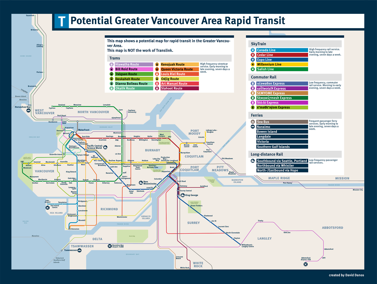
Not mine but this is pretty cool
Also pretty biased - very heavy in Vancouver / Burnaby / Richmond with very little in Surrey and Langley.

Speaking just about the Skytrain lines:

* The Expo line is short by one stop (Willowbrook and downtown Langley are separate stations).

* The Canada Line. We've talked about on here a lot - it's going to be a really long time before that's extended (complete with rebuilding the Lansdowne to Brighouse section). Some other variety of rail is more likely.

* The Cedar Line isn't possible - Skytrain can only do a grade of 6% and Burnaby Mountain is higher than that (I think someone figured it out here and it was decidedly higher than 6%) and doubling both Evergreen and Expo to have a one seat ride to Surrey...

* The Salish Line. I can't speak about the North Shore section. They probably looked at google maps and saw the center median along Boundary and thought 'lets put it there!' without noticing the transmission towers and that both the Millennium Line and Grandview Hwy are above ground, which makes about 4km of that route difficult to impossible. Plus Willingdon makes way more sense for a Skytrain.


Quote:
Originally Posted by wrenegade View Post
There is a lot of dumb stuff on that map. Musqueam, Dunbar and MacKenzie stops along 41st & SW Marine?, Cypress and Sentinel stop in West Van? No Marine Drive or Lonsdale (except above the highway?) stops in North Van? 5 lines in Richmond, yet somehow no Queensborough stop? Boundary Bay airport (with no scheduled service) gets a stop but no stop in Ladner? Sorry, throw this away and start again. Oh, and good luck have people pronounce those commuter rail line names.
I can barely even read them, much less pronounce them
Reply With Quote
     
     
  #1306  
Old Posted Sep 6, 2017, 12:08 AM
trofirhen trofirhen is offline
Registered User
 
Join Date: Oct 2008
Posts: 8,845
Huh?

Quote:
Originally Posted by wrenegade View Post
There is a lot of dumb stuff on that map. Musqueam, Dunbar and MacKenzie stops along 41st & SW Marine?, Cypress and Sentinel stop in West Van? No Marine Drive or Lonsdale (except above the highway?) stops in North Van? 5 lines in Richmond, yet somehow no Queensborough stop? Boundary Bay airport (with no scheduled service) gets a stop but no stop in Ladner? Sorry, throw this away and start again. Oh, and good luck have people pronounce those commuter rail line names.
May I second that, please? Some of the lines have validity in their routing and planning, but it's rather hodge-podge, and the line names are right out of Skookumchuck City. Bizarre.
Reply With Quote
     
     
  #1307  
Old Posted Sep 6, 2017, 12:27 AM
Migrant_Coconut's Avatar
Migrant_Coconut Migrant_Coconut is offline
Registered User
 
Join Date: Oct 2015
Location: Kitsilano/Fairview
Posts: 8,396
Agreed and agreed. Good effort - and this IS the Fantasy thread - but it seems more like a "drawing lines on a map" kind of plan than something workable.

While we're at it, I found this one a few months ago:

Reply With Quote
     
     
  #1308  
Old Posted Sep 6, 2017, 12:43 AM
cganuelas1995 cganuelas1995 is offline
Registered User
 
Join Date: Jan 2017
Posts: 1,276
Quote:
Originally Posted by trofirhen View Post
May I second that, please? Some of the lines have validity in their routing and planning, but it's rather hodge-podge, and the line names are right out of Skookumchuck City. Bizarre.
The guy who made it did say that:

Quote:
And I agree that Vancouverites can probably adapt well enough to these names as they have some exposure to the Squamish language on a somewhat regular basis. It’s non-locals that I’m thinking more of… if I was presented with “Sḵwx̱wú7mesh” without the transliteration (which the sign above helpfully provides, unlike David’s map), I really wouldn’t know where to start.

Then again, the names are used mainly for commuter rail services, which are far more likely to be used by locals than visitors, so maybe the whole point is moot.
Because fuck the tourists who might be using commuter lines to travel between their AirBnB in the suburbs and Downtown Vancouver.

When I was on vacation in Melbourne for 3 weeks, I stayed in AirBnBs in the suburb. Their train lines have very simple names, named after the outer stations they terminate at, with a few exceptions of course.
Reply With Quote
     
     
  #1309  
Old Posted Sep 6, 2017, 1:11 AM
Migrant_Coconut's Avatar
Migrant_Coconut Migrant_Coconut is offline
Registered User
 
Join Date: Oct 2015
Location: Kitsilano/Fairview
Posts: 8,396
At least if it were, let's say, Icelandic, Czech or Maori, they'd be using the standard Western alphabet - most of us could make an educated guess. Whereas somebody coming from overseas or up from the south will look at these consonants, give up immediately and call it the "Green Line" or something. Not a good way to preserve or promote the language.
Reply With Quote
     
     
  #1310  
Old Posted Sep 6, 2017, 1:22 AM
cganuelas1995 cganuelas1995 is offline
Registered User
 
Join Date: Jan 2017
Posts: 1,276
Quote:
Originally Posted by Migrant_Coconut View Post
At least if it were, let's say, Icelandic, Czech or Maori, they'd be using the standard Western alphabet - most of us could make an educated guess. Whereas somebody coming from overseas or up from the south will look at these consonants, give up immediately and call it the "Green Line" or something. Not a good way to preserve or promote the language.
Having the route/line named after the destination would be much easier. Though if some routes have the same destination, for example, the eastbound 401/3/4 and C93 all terminating at Riverport Recreational Complex and having the same route name that says "401/3/4/C93 Riverport" would be a bit confusing.

So, I think it would be better to differentiate by means of showing where it's passing through, for example, "401 Riverport via Garden City Road" or "404 Riverport via Four Road" instead of "404 Four Road", because people inexperienced with the transit system, i.e. tourists or young people or people who normally drive who are using it for the first time or people who rarely use public transit, would think it would terminate at the end of No. 4 road.
Reply With Quote
     
     
  #1311  
Old Posted Sep 6, 2017, 1:42 AM
Sheba Sheba is offline
Registered User
 
Join Date: Jan 2015
Location: BC
Posts: 4,305
How about we talk about routes instead of what to call them. I've wondered why people keep wanting to extend Skytrain in Richmond from Brighouse Station down to Steveston and No 1 Road (west Richmond). It would make more sense to put some form of rail from Bridgeport Station down Hwy 99 to Steveston (east Richmond) and have a big bus loop there - it would replace a lot of buses that take that route.
Reply With Quote
     
     
  #1312  
Old Posted Sep 6, 2017, 2:10 AM
cganuelas1995 cganuelas1995 is offline
Registered User
 
Join Date: Jan 2017
Posts: 1,276
Quote:
Originally Posted by Sheba View Post
How about we talk about routes instead of what to call them. I've wondered why people keep wanting to extend Skytrain in Richmond from Brighouse Station down to Steveston and No 1 Road (west Richmond). It would make more sense to put some form of rail from Bridgeport Station down Hwy 99 to Steveston (east Richmond) and have a big bus loop there - it would replace a lot of buses that take that route.
I think a DMU line using Alstom LINTs going from Bridgeport Station to a new intermodal transit station in Ladner CBD (I envision one on Trunk sandwiched between Trenant Park Square and Ladner Centre/Save On Foods mall, perhaps there might be a new development there), replacing Ladner Exchange, which is quite far from the population and the jobs.

Moving the McDicks to the centre of town would be better too.
Reply With Quote
     
     
  #1313  
Old Posted Sep 6, 2017, 2:52 AM
moosejaw moosejaw is offline
Registered User
 
Join Date: Apr 2012
Location: Miami
Posts: 475
Quote:
Originally Posted by cganuelas1995 View Post
I think a DMU line using Alstom LINTs going from Bridgeport Station to a new intermodal transit station in Ladner CBD (I envision one on Trunk sandwiched between Trenant Park Square and Ladner Centre/Save On Foods mall, perhaps there might be a new development there), replacing Ladner Exchange, which is quite far from the population and the jobs.

Moving the McDicks to the centre of town would be better too.
I have asked you this before and you did not provide a clear answer?
How do you get a rail line to cross the fraser river?
Reply With Quote
     
     
  #1314  
Old Posted Sep 6, 2017, 3:15 AM
Sheba Sheba is offline
Registered User
 
Join Date: Jan 2015
Location: BC
Posts: 4,305
Quote:
Originally Posted by moosejaw View Post
I have asked you this before and you did not provide a clear answer?
How do you get a rail line to cross the fraser river?
Yeah we're going to have to wait and find out what happens with the Massey tunnel / bridge before making any river crossing rail plans. My idea of stopping it in Richmond before that is looking better than ever.

Quote:
Originally Posted by cganuelas1995 View Post
I think a DMU line using Alstom LINTs going from Bridgeport Station to a new intermodal transit station in Ladner CBD (I envision one on Trunk sandwiched between Trenant Park Square and Ladner Centre/Save On Foods mall, perhaps there might be a new development there), replacing Ladner Exchange, which is quite far from the population and the jobs.

Moving the McDicks to the centre of town would be better too.
Why are the exchanges on the edges of town? The Tsawwassen one is literally on the edge of town - would it kill TransLink to move it just over 1km south to where the mall is? Sure that's not the physical center of town but at least it's in Tsawwassen.
Reply With Quote
     
     
  #1315  
Old Posted Sep 6, 2017, 3:19 AM
cganuelas1995 cganuelas1995 is offline
Registered User
 
Join Date: Jan 2017
Posts: 1,276
Quote:
Originally Posted by moosejaw View Post
I have asked you this before and you did not provide a clear answer?
How do you get a rail line to cross the fraser river?
I believe I gave the answer already of having it follow the bridge and, depending on the maximum grade (the steepest adhesion railway is 14.5% (Calçada de São Francisco, Lisbon, Portugal)) and speed (LINT has operating speed ranging between 100 and 180km/h).
Reply With Quote
     
     
  #1316  
Old Posted Sep 6, 2017, 3:27 AM
cganuelas1995 cganuelas1995 is offline
Registered User
 
Join Date: Jan 2017
Posts: 1,276
Quote:
Originally Posted by Sheba View Post
Yeah we're going to have to wait and find out what happens with the Massey tunnel / bridge before making any river crossing rail plans. My idea of stopping it in Richmond before that is looking better than ever.


Why are the exchanges on the edges of town? The Tsawwassen one is literally on the edge of town - would it kill TransLink to move it just over 1km south to where the mall is? Sure that's not the physical center of town but at least it's in Tsawwassen.
And would it kill TransLink to consolidate the Richmond-Brighouse bus bays, or at least have an unloading bay?

Or at least order buses to stop and wait for passengers to transfer.

Because some of the bays, like 5a are literally miles away from the station.
Reply With Quote
     
     
  #1317  
Old Posted Sep 6, 2017, 3:32 AM
moosejaw moosejaw is offline
Registered User
 
Join Date: Apr 2012
Location: Miami
Posts: 475
Quote:
Originally Posted by cganuelas1995 View Post
I believe I gave the answer already of having it follow the bridge and, depending on the maximum grade (the steepest adhesion railway is 14.5% (Calçada de São Francisco, Lisbon, Portugal)) and speed (LINT has operating speed ranging between 100 and 180km/h).
What you just quoted is a tram car.
LINTs operating speed that you quoted doesnt indicate if it can ascent a climb as drastic one will need to cross the fraser.

Please start again
Reply With Quote
     
     
  #1318  
Old Posted Sep 6, 2017, 3:55 AM
cganuelas1995 cganuelas1995 is offline
Registered User
 
Join Date: Jan 2017
Posts: 1,276
Quote:
Originally Posted by moosejaw View Post
What you just quoted is a tram car.
LINTs operating speed that you quoted doesnt indicate if it can ascent a climb as drastic one will need to cross the fraser.

Please start again
Oh fuck me, I forgot to finish the sentence.

...and, depending on the maximum grade and speed, adjust the starting point of the slope accordingly.

Also, tram cars tend to go slower, so my theory is that a higher speed will allow the DMU to cross the fraser easier.
Reply With Quote
     
     
  #1319  
Old Posted Sep 6, 2017, 4:12 AM
bardak bardak is offline
Registered User
 
Join Date: Oct 2010
Posts: 356
Quote:
Originally Posted by moosejaw View Post
What you just quoted is a tram car.
LINTs operating speed that you quoted doesnt indicate if it can ascent a climb as drastic one will need to cross the fraser.

Please start again
While the railway that was quoted was a tram the same reason it can climb a 14%+ grade is the same reason you could do a passenger train bridge over the Fraser. You seem to be assuming that all trains are only capable of climbing a very small grades that most mainline rail is designed with. A small tram like the one previously quoted can climb high grades due to a higher power to weight ratio. I believe that most mainline rail is designed for a 1% grade but a passenger rail line run on a 3.5% grade. A 3.5% grade would require approaches of approximately 1.5km which is long but not unreasonable.
Reply With Quote
     
     
  #1320  
Old Posted Sep 6, 2017, 5:23 AM
Migrant_Coconut's Avatar
Migrant_Coconut Migrant_Coconut is offline
Registered User
 
Join Date: Oct 2015
Location: Kitsilano/Fairview
Posts: 8,396
A) Either it's light rail, in which case an express bus does the same job for less money (and can use the exit ramps),

B) Or it's heavy rail, in which case a bridge with a shallow-enough grade would cost almost as much as the GMB. We've been over this.
Reply With Quote
     
     
This discussion thread continues

Use the page links to the lower-right to go to the next page for additional posts
 
 
Reply

Go Back   SkyscraperPage Forum > Regional Sections > Canada > Alberta & British Columbia > Vancouver > Transportation & Infrastructure
Forum Jump


Forum Jump


All times are GMT. The time now is 2:10 PM.

     
SkyscraperPage.com - Archive - Privacy Statement - Top

Powered by vBulletin® Version 3.8.7
Copyright ©2000 - 2024, vBulletin Solutions, Inc.