HomeDiagramsDatabaseMapsForum About
     

Go Back   SkyscraperPage Forum > Regional Sections > Canada > Ontario > Ottawa-Gatineau > Transportation


Reply

 
Thread Tools Display Modes
     
     
  #241  
Old Posted Nov 14, 2010, 3:17 PM
waterloowarrior's Avatar
waterloowarrior waterloowarrior is offline
National Capital Region
 
Join Date: Nov 2005
Location: Eastern Ontario
Posts: 9,244
sharing rural pathways policy open house for the two new pathways in osgoode and cumberland
http://ottawa.ca/residents/public_co.../index_en.html
Reply With Quote
     
     
  #242  
Old Posted Nov 14, 2010, 3:18 PM
waterloowarrior's Avatar
waterloowarrior waterloowarrior is offline
National Capital Region
 
Join Date: Nov 2005
Location: Eastern Ontario
Posts: 9,244
Multi-Use Pathway Crossing of the Rideau River Environmental Assessment Study
The City of Ottawa will shortly be providing a formal Notice of Study Commencement for the Environmental Assessment (EA) for a future multi-use pathway crossing of the Rideau River in the vicinity of Donald Street and Somerset Street East. This proposed pedestrian and cycling crossing would link the Overbrook and Vanier communities with the Sandy Hill community and the downtown area.

The project is being planned as a Schedule ‘C’ project under the Municipal Class Environmental Assessment (2007) document. The intent of the undertaking is to develop a Recommended Plan for a future multi-use pathway connection to better connect residents between neighbouring communities, as previously identified in the City’s Sandy Hill Secondary Plan of the current Official Plan, Ottawa Cycling Plan (2008) and Ottawa Pedestrian Plan (2009). The EA Study will document existing environmental conditions, look at the need for the crossing, examine alternatives and potential impacts, and recommend mitigation measures to minimize environmental impacts.

A first Public Open House on this project is planned for January 2011 and more details as to time and location will be posted on this web page together with the Notice of Study Commencement of this Environmental Assessment.


Update on Train/Coventry bridge (public meeting Sept 2010 display board)


(one of 3 design concepts)
Reply With Quote
     
     
  #243  
Old Posted Nov 14, 2010, 3:19 PM
waterloowarrior's Avatar
waterloowarrior waterloowarrior is offline
National Capital Region
 
Join Date: Nov 2005
Location: Eastern Ontario
Posts: 9,244
Segregated Bike Lane Project

Public Meeting #2
Thursday November 25, 2010
6:30 to 8:30 p.m. (Presentation at 7 p.m.)
City Hall – Rotunda
110 Laurier Avenue West, Ottawa
What is this meeting about?
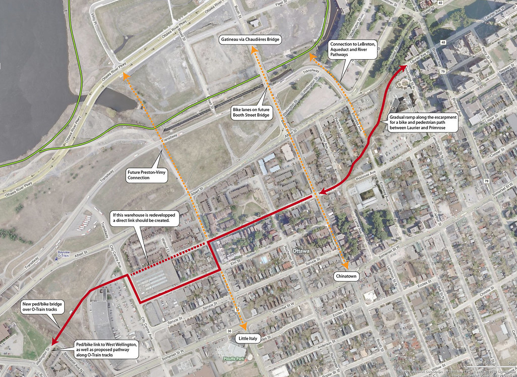
The City of Ottawa is finalizing a study for an east-west segregated bike lane through the downtown. A segregated bike lane is a designated on-street bicycle lane that is separated from motor vehicle traffic through the use of physical buffers (curbs, planter boxes, parked cars, etc.). This second public meeting is to gather feedback on the preferred route (Laurier Avenue West) and functional designs.


Why attend?
The purpose of this meeting is to:

Present the route evaluation criteria and analysis;
Present the preferred route (Laurier Avenue West) and functional designs;
Provide opportunities for you to become involved in the identification of local issues and the development of the facility.
Need more information?
If you are not available to attend the meeting or would like additional information, please visit the project website at ottawa.ca/bikelane or direct your comments and questions to the project manager listed below. The presentation material for the meeting will be available on the project website after November 25, 2010.

Colin Simpson MCIP RPP
Senior Project Manager
City of Ottawa
110 Laurier Avenue West, 4th Floor
Ottawa ON K1P 1J1
Tel: 613-580-2424, ext. 27881
Fax: 613-580-2578
E-mail: colin.simpson@ottawa.ca
Reply With Quote
     
     
  #244  
Old Posted Nov 14, 2010, 3:49 PM
McC's Avatar
McC McC is offline
Registered User
 
Join Date: Apr 2010
Posts: 3,057
Laurier's definitely the best on the east side of downtown -- better connections to the Canal and Rideau River paths, but accessing it on the west side isn't as good as Queen which connects to the Albert-Scott pathway... another example of the meandering routes that buses, bikes and cars all have to take all over this city because so few streets line up properly / don't end suddenly / etc. (e.g. anyone ever wonder why Gladstone, Tyndale and Byron couldn't have been connected at some point?)
Reply With Quote
     
     
  #245  
Old Posted Nov 14, 2010, 10:20 PM
Dado's Avatar
Dado Dado is offline
National Capital Region
 
Join Date: Jul 2007
Location: Ottawa, Canada
Posts: 2,521
Quote:
Originally Posted by McC View Post
Laurier's definitely the best on the east side of downtown -- better connections to the Canal and Rideau River paths, but accessing it on the west side isn't as good as Queen which connects to the Albert-Scott pathway...
If you want to spend some minor megabucks, one could send a pathway across the old Ottawa Technical HS site then through a tunnel diagonally under the Slater-Bronson intersection as a way to get to the Ottawa River and Scott Street pathways to the west from this new facility on Laurier.

Quote:
another example of the meandering routes that buses, bikes and cars all have to take all over this city because so few streets line up properly / don't end suddenly / etc. (e.g. anyone ever wonder why Gladstone, Tyndale and Byron couldn't have been connected at some point?)
Funnily enough, such a connection between Byron and Gladstone (minus Tyndale) is actually in the Gréber Plan! If only the NCC had used its razing powers for good...

https://qshare.queensu.ca/Users01/go.../plate%209.jpg
__________________
Ottawa's quasi-official motto: "It can't be done"
Ottawa's quasi-official ethos: "We have a process to follow"
Reply With Quote
     
     
  #246  
Old Posted Nov 15, 2010, 3:43 AM
lrt's friend lrt's friend is offline
Registered User
 
Join Date: Dec 2006
Posts: 11,865
Quote:
Multi-Use Pathway Crossing of the Rideau River Environmental Assessment Study
The City of Ottawa will shortly be providing a formal Notice of Study Commencement for the Environmental Assessment (EA) for a future multi-use pathway crossing of the Rideau River in the vicinity of Donald Street and Somerset Street East. This proposed pedestrian and cycling crossing would link the Overbrook and Vanier communities with the Sandy Hill community and the downtown area.
When Overbrook was first subdivided in 1911, one of the sales pitches was a foot bridge that connected to the Laurier Avenue streetcar. That foot bridge, located near the Rideau Tennis Club, appears on old Ottawa maps. No doubt lost to one of the many Rideau River floods in the old days. What comes around, goes around.
Reply With Quote
     
     
  #247  
Old Posted Nov 15, 2010, 6:19 PM
Radster Radster is offline
Registered User
 
Join Date: Oct 2007
Location: Chelsea
Posts: 997
Pardon my ignorance, but whatever happened to the Somerset Street East-West segregated bike lane pilot project? Was it defeated by the business owners on Somerset who managed to convince city council that eliminating parking on one side of the street will hurt business?

As much as I am happy that there will be a pilot project next year on Laurier for an East-West lane, I am also disappointed and worried that it will fail due to it being half-assed, mainly due the lane just ending suddenly at Bronson on the west end of Laurier, and in the east at Elgin (why not continue over the canal and through Sandy Hill?.

After all these studies, guest expert speakers, conference in Copenhagen, and world class successfull examples a stones throw away in MTL, I find it rather uninspiring that our City Hall is so damn cautious, conservative and easily influenced by the businesses rather than betting on and using success stories from elsewhere.
Reply With Quote
     
     
  #248  
Old Posted Nov 15, 2010, 7:54 PM
Dado's Avatar
Dado Dado is offline
National Capital Region
 
Join Date: Jul 2007
Location: Ottawa, Canada
Posts: 2,521


Strictly speaking, there never was a Somerset segregated bike lane pilot project; what there is is A segregated bike lane pilot project, location to be decided. Somerset was merely an early favourite, and Gladstone an even earlier favourite.

As for it being half-assed, of course it will be half-assed. It's being "planned" by engineers who still think it is acceptable to make cyclists cross roads illegally in pedestrian crosswalks. As I wrote some time earlier, our engineers have no business designing segregated facilities until such time as they can manage to design a proper bike path - road intersection first. They can start with the one at the War Museum going across Booth.
__________________
Ottawa's quasi-official motto: "It can't be done"
Ottawa's quasi-official ethos: "We have a process to follow"
Reply With Quote
     
     
  #249  
Old Posted Nov 15, 2010, 8:26 PM
McC's Avatar
McC McC is offline
Registered User
 
Join Date: Apr 2010
Posts: 3,057
Quote:
Originally Posted by Dado View Post
Funnily enough, such a connection between Byron and Gladstone (minus Tyndale) is actually in the Gréber Plan! If only the NCC had used its razing powers for good...

https://qshare.queensu.ca/Users01/go.../plate%209.jpg
and all of those bridges across the Canal and Rideau River are pretty à propos to this discussion as well.

le sigh.
Reply With Quote
     
     
  #250  
Old Posted Nov 15, 2010, 9:31 PM
Kitchissippi's Avatar
Kitchissippi Kitchissippi is offline
Busy Beaver
 
Join Date: Nov 2005
Location: Ottawa
Posts: 4,364
Quote:
Originally Posted by Dado View Post
If you want to spend some minor megabucks, one could send a pathway across the old Ottawa Technical HS site then through a tunnel diagonally under the Slater-Bronson intersection as a way to get to the Ottawa River and Scott Street pathways to the west from this new facility on Laurier.
It would be simpler and cheaper to build a ped/bike overpass from the western end of Laurier at the escarpment going over Albert and Scott.

If I ever win mega millions in the lottery, I'd buy up the houses between Gladstone and Byron, punch a bike path through there and redevelop the land with cyclist-oriented townhouses along it Wish me luck.
Everyone keeps saying "Tyndale" when it's Tyndall.
Reply With Quote
     
     
  #251  
Old Posted Nov 15, 2010, 9:58 PM
McC's Avatar
McC McC is offline
Registered User
 
Join Date: Apr 2010
Posts: 3,057
Quote:
Originally Posted by Kitchissippi View Post
.
Everyone keeps saying "Tyndale" when it's Tyndall.
oops, you're absolutely right!
Reply With Quote
     
     
  #252  
Old Posted Nov 16, 2010, 5:01 AM
Dado's Avatar
Dado Dado is offline
National Capital Region
 
Join Date: Jul 2007
Location: Ottawa, Canada
Posts: 2,521
Quote:
Originally Posted by Kitchissippi View Post
It would be simpler and cheaper to build a ped/bike overpass from the western end of Laurier at the escarpment going over Albert and Scott.
That seems like a lot of climbing... not sure how well-used that would be.

Quote:
If I ever win mega millions in the lottery, I'd buy up the houses between Gladstone and Byron, punch a bike path through there and redevelop the land with cyclist-oriented townhouses along it Wish me luck.
Will do, though technically you require only six houses on what look to be 33' lots so I'm not sure how much there would be to redevelop afterwards, unless you're envisioning a "direct" diagonal route, which would require a few more properties.

Quote:
Everyone keeps saying "Tyndale" when it's Tyndall.
Ya, didn't look, just took it as a given since it sounded about right.
__________________
Ottawa's quasi-official motto: "It can't be done"
Ottawa's quasi-official ethos: "We have a process to follow"
Reply With Quote
     
     
  #253  
Old Posted Nov 16, 2010, 4:32 PM
Kitchissippi's Avatar
Kitchissippi Kitchissippi is offline
Busy Beaver
 
Join Date: Nov 2005
Location: Ottawa
Posts: 4,364
Quote:
Originally Posted by Dado View Post
That seems like a lot of climbing... not sure how well-used that would be.
I could be something like this, but if that climb is still too steep, a bike spiral could be built next to the Good Companions building


Speaking of bike spirals and admirable investment in cycling facilities, I rode to Montreal earlier in the spring and to get into the island they've put segregated bike lanes on the A-20 bridge. To access it from Ste-Anne-de Bellevue this bike spiral was being put into place (should be completed by now):

Reply With Quote
     
     
  #254  
Old Posted Nov 17, 2010, 12:56 AM
Dado's Avatar
Dado Dado is offline
National Capital Region
 
Join Date: Jul 2007
Location: Ottawa, Canada
Posts: 2,521
You're still climbing a lot of height and then shedding some of it (east of Bronson). It's extra work and people will probably take some other route. That's why I suggested going under Slater/Bronson, since such a tunnel would lessen the grade of a climb that has to be taken regardless and for which there are no easier options. That would tend to ensure it gets used as intended.
__________________
Ottawa's quasi-official motto: "It can't be done"
Ottawa's quasi-official ethos: "We have a process to follow"
Reply With Quote
     
     
  #255  
Old Posted Nov 20, 2010, 5:05 PM
waterloowarrior's Avatar
waterloowarrior waterloowarrior is offline
National Capital Region
 
Join Date: Nov 2005
Location: Eastern Ontario
Posts: 9,244
The draft report and block designs for the laurier lane have been posted on the city`s website
http://ottawa.ca/residents/public_co.../index_en.html
Reply With Quote
     
     
  #256  
Old Posted Nov 20, 2010, 6:00 PM
Ottawan Ottawan is offline
Citizen-at-large
 
Join Date: Aug 2009
Location: Expat (in Toronto)
Posts: 738
Having glanced through the report and looked at the designs, I'm actually pretty impressed. This will be (even as a pilot project) a very permanent-looking solution. The connections to the east make a lot of sense, and the segregation is conducted via curb & bollard. The only thing really lacking is an easy connection in the west.
Reply With Quote
     
     
  #257  
Old Posted Nov 21, 2010, 6:58 AM
DarkArconio DarkArconio is offline
Registered User
 
Join Date: Mar 2010
Posts: 182
In the western most image, a new multi-use pathway through the park next to the old technical highschool is show penciled in. Does anyone has a link to more complete plans with this path? Will it be connecting to the currently broken multi-use path the goes through the lebreton flats along the pumping plant canal, connecting to the river path on both ends? The bronson intersections with albert and slater would be hellish to navigate, but with proper implementation (signage and separated lanes like along laurier) could provide a truly continuous path.
Reply With Quote
     
     
  #258  
Old Posted Nov 21, 2010, 4:24 PM
Kitchissippi's Avatar
Kitchissippi Kitchissippi is offline
Busy Beaver
 
Join Date: Nov 2005
Location: Ottawa
Posts: 4,364
Quote:
Originally Posted by Dado View Post
You're still climbing a lot of height and then shedding some of it (east of Bronson). It's extra work and people will probably take some other route. That's why I suggested going under Slater/Bronson, since such a tunnel would lessen the grade of a climb that has to be taken regardless and for which there are no easier options. That would tend to ensure it gets used as intended.
After biking around the area, here's a revised idea, which actually results in less encounters with traffic and creates new connections between neighbourhoods:

Reply With Quote
     
     
  #259  
Old Posted Nov 22, 2010, 8:01 PM
Radster Radster is offline
Registered User
 
Join Date: Oct 2007
Location: Chelsea
Posts: 997
Some of my observations:

- I like the left turn areas for cyclists, remains to be seen if this will be respected/used by cyclists.

- No integration with Lyon street bike lane, how do bikers going South on Lyon turn left (East) onto the Laurier street bike lane safely? Simple solution, make a cyclist left turn area on the South-West part of the intersection.

- Similar issue with left turns from Bay street bike lane going West on Laurier

- Will the traffic lights be reprogrammed on Laurier street? They do this in Copenhagen, so that someone biking around 20km/hr manages to bike through all the intersections without having to stop at each one.


- Beyond Bronson street - remains to be seen what they do there.

Last edited by Radster; Nov 22, 2010 at 11:21 PM.
Reply With Quote
     
     
  #260  
Old Posted Nov 23, 2010, 3:32 PM
TransitZilla TransitZilla is offline
Registered User
 
Join Date: Dec 2006
Posts: 2,738
http://www.ottawasun.com/news/ottawa.../16263221.html

Quote:
Google adds Canadian bike routes to maps
By KENNETH JACKSON, Ottawa Sun


Google will soon help Ottawa cyclists navigate the city’s many trails when the search engine launches the latest addition to its maps program later this week.

Cyclists will be able to find cycling directions and bike trail data in Google Maps much like motorists already can at maps.google.ca, said Shannon Guymon of Google Canada Monday during a press conference at the Chateau Laurier in downtown Ottawa.

The system is also being launched in Gatineau, Toronto, Edmonton, Vancouver, Calgary, Winnipeg, Kelowna and Waterloo. It should be live within days.

Guymon said new map tool is the “top requested feature of users.”

It will also help cyclists avoid dangerous roads and hills if they wish.

“By integrating NCC’s recreational pathways with city of Ottawa and Gatineau cycling lanes and paths, Canada’s capital region becomes the first region in the country to have its entire cycling network on Google Maps,” said Marie Lemay, CEO of the National Capital Commission. “This new feature is no doubt a step in the right direction to improve cycling in the capital region.”

Google worked with NCC and officials from Ottawa and Gatineau to make this a reality.

Lemay said the NCC has more than 220 km of biking trails while Nancy Schepers, deputy city manager for the city, said Ottawa will have 700 km of trails by the end of 2011.

The maps will be colour coded. Dark green will indicate a dedicated bike-only trial, lighter green is a bike lane along a road and a dotted green line means roads that do not have bike lanes but tend to be used by cyclists.

Google launched the program in the United States in March with more than 12,000 miles of trails mapped in 150 cities.

Gatineau Mayor Marc Bureau said he hopes the new tool promotes active and healthy transportation.

Riders will also be able to provide feedback to keep the system up to date.

kenneth.jackson@sunmedia.ca
Reply With Quote
     
     
This discussion thread continues

Use the page links to the lower-right to go to the next page for additional posts
 
 
Reply

Go Back   SkyscraperPage Forum > Regional Sections > Canada > Ontario > Ottawa-Gatineau > Transportation
Forum Jump


Forum Jump


All times are GMT. The time now is 1:48 PM.

     
SkyscraperPage.com - Archive - Privacy Statement - Top

Powered by vBulletin® Version 3.8.7
Copyright ©2000 - 2024, vBulletin Solutions, Inc.