HomeDiagramsDatabaseMapsForum About
     

Go Back   SkyscraperPage Forum > Regional Sections > Canada > Alberta & British Columbia > Vancouver > Transportation & Infrastructure


Reply

 
Thread Tools Display Modes
     
     
  #221  
Old Posted Sep 29, 2018, 3:55 AM
BCPhil BCPhil is offline
Registered User
 
Join Date: Jun 2009
Location: Surrey
Posts: 2,578
Quote:
Originally Posted by jhausner View Post
Also on the topic of a deep port at Powell River... why? I don't see the use case honestly.

Ships coming in will come through the south of Vancouver Island around Victoria. Powell River is a lot further and more fuel burn to get to than anywhere in Metro Vancouver today. They are working on expanding Roberts Bank in Tsawwassen and I don't believe demand is growing fast enough that Port Metro Vancouver would need to expand up to Powell River.

Just don't really see a business case honestly. I also don't think the growth potential is that great. Could you imagine the towns on the Sunshine Coast ballooning in population?

Let's just say all the cities on the Sunshine Coast tripled in size. Tripled.

The whole Sunshine Coast = 26,000 --> 78,000 (tripled)
Powell River = 13,000 --> 39,000 (tripled)

So assuming both the entire Sunshine Coast + Powell River TRIPLED in population over say 30 years with a fixed link (which is completely unrealistic you have to admit), the final population of the entire area is basically the population of Delta spread along a distance that is West Vancouver to Chilliwack.

117,000 people spread along 131 km.

Again that is with the population existing today tripling.

There's just no business case I can see it's a pipe dream at best, and anyone wanting to "get out of Metro Vancouver" will just move to Squamish or Chilliwack like they do today. If the Sunshine Coast was opened up to a fix link anyway it would drive up prices because they would just become another West Vancouver only with more developable land = big mansions. It's just silly. I'd rather see all that money to go infrastructure that is needed in BC.
Honestly, that sounds like a lot of people. That's about the population of the North Shore, and they have 2 bridges. West Kelowna is 32,000 people and they have a nice 5 lane bridge into downtown Kelowna. The population of Astoria is 9000 and has a 6km long bridge across the Columbia.


Like I don't think it's proper to just dismiss a population in this province out of hand just because you don't think they are useful enough.

I'm not saying I support a fixed crossing, but they have been paying taxes for decades and have seen very little in return from the government in increased services and quality of life, while other parts of this province get huge cash infusions.

We used to be pretty good at building highways in this province. It probably doesn't need to be something as shiny as the Coq. Something along the lines of Highway 4 out to Tofino (which has a 90km highway to serve about 3500 residents) or like highway 28 to Gold River (a 90km highway serving 1200) would be adequate.
Reply With Quote
     
     
  #222  
Old Posted Sep 29, 2018, 4:28 AM
Migrant_Coconut's Avatar
Migrant_Coconut Migrant_Coconut is offline
Registered User
 
Join Date: Oct 2015
Location: Kitsilano/Fairview
Posts: 8,396
Nobody's blowing off the Sunshine Coast, only saying that we need to put things into perspective. We're not talking about one town of 9,000 people in one spot, we're talking about a dozen towns of 2-3k scattered all up and down the region. We're not talking about a $200 million pontoon or cantilever, we're talking about a full-blown suspension bridge and 100+ klicks of highway; the George Massey and Oak upgrades alone are $8 billion and have Vancouver screaming bloody murder. It's not that the Coast is too small, it's that they're too small, too scattered and too far away.

The North Shore's population is actually about 175,000 right now. And since we're tripling everything for the sake of the argument, it'd be closer to half a million. Whatever it'd cost to get a highway to Powell River would likely pay for three SkyTrain lines over Burrard Inlet - we'd have to do it anyway, just so Coast drivers don't get stuck in gridlock as soon as they get here.
Reply With Quote
     
     
  #223  
Old Posted Nov 23, 2018, 1:34 AM
fredinno's Avatar
fredinno fredinno is offline
Registered User
 
Join Date: Jan 2012
Posts: 2,317
In my opinion, this is basically Vancouver's Geoga Bridge: https://en.wikipedia.org/wiki/Busan–Geoje_Fixed_Link

Which was largely built for real estate reasons- Busan is pretty dense, after all.
It's also a decent analogue of what the span might look like, minus the underwater part- just imagine a larger bridge there, on the span closest to the Sea-to-Sky.

The same rationale for building the bridge there is likely similar to why we'd build it for the Sunshine Coast.


The span across Anvil Island would be two 2.20km +2.8km spans.

Meanwhile, span across Bowen Island would be three bridges: one 2.8 km, one 2.48 km, and one 2.31 km.

In comparison, the Geoga Bridge is 3 bridges- one 1.87 km, one 1.65 km, and one 3.2 km underwater submerged tunnel.

Overall span is comparible to the Bowen Island bridge.


Obviously the latter is much better for the Real Estate Purpose, though it would run into NIMBYs on Bowen Island, and would cost at least 50% more.


It'd be great- but it would be opposed by NIMBYs on all sides, and densification, and cutting into the ALR will always be cheaper. Critics would complain that it's a bridge to nowhere.
Reply With Quote
     
     
  #224  
Old Posted Nov 23, 2018, 5:58 AM
Migrant_Coconut's Avatar
Migrant_Coconut Migrant_Coconut is offline
Registered User
 
Join Date: Oct 2015
Location: Kitsilano/Fairview
Posts: 8,396
Quote:
Originally Posted by fredinno View Post
In my opinion, this is basically Vancouver's Geoga Bridge: https://en.wikipedia.org/wiki/Busan–Geoje_Fixed_Link

Which was largely built for real estate reasons- Busan is pretty dense, after all.
It's also a decent analogue of what the span might look like, minus the underwater part- just imagine a larger bridge there, on the span closest to the Sea-to-Sky.

The same rationale for building the bridge there is likely similar to why we'd build it for the Sunshine Coast.


The span across Anvil Island would be two 2.20km +2.8km spans.

Meanwhile, span across Bowen Island would be three bridges: one 2.8 km, one 2.48 km, and one 2.31 km.

In comparison, the Geoga Bridge is 3 bridges- one 1.87 km, one 1.65 km, and one 3.2 km underwater submerged tunnel.

Overall span is comparible to the Bowen Island bridge.


Obviously the latter is much better for the Real Estate Purpose, though it would run into NIMBYs on Bowen Island, and would cost at least 50% more.


It'd be great- but it would be opposed by NIMBYs on all sides, and densification, and cutting into the ALR will always be cheaper. Critics would complain that it's a bridge to nowhere.
If Gibsons or Sechelt had a population of 244k like Geoje does, I suspect that we'd already have built a bridge. The entire Coast has a tenth that many residents.
Reply With Quote
     
     
  #225  
Old Posted Nov 23, 2018, 8:38 PM
fredinno's Avatar
fredinno fredinno is offline
Registered User
 
Join Date: Jan 2012
Posts: 2,317
Quote:
Originally Posted by Migrant_Coconut View Post
If Gibsons or Sechelt had a population of 244k like Geoje does, I suspect that we'd already have built a bridge. The entire Coast has a tenth that many residents.
True, but they weren't the primary reason it was built .


Still, it's probably 50 years away, or probably the next round of highway expansions, along with the proposed New West Tunnel, upgrading Hwy 7 to expressway standard, etc.
Reply With Quote
     
     
  #226  
Old Posted Nov 23, 2018, 9:32 PM
waves's Avatar
waves waves is offline
waves
 
Join Date: Jun 2015
Location: North Vancouver
Posts: 366
Fighting Bowen Residents is one Nimby fight you won't win.
Reply With Quote
     
     
  #227  
Old Posted Nov 23, 2018, 11:48 PM
Alex Mackinnon's Avatar
Alex Mackinnon Alex Mackinnon is offline
Can I has a tunnel?
 
Join Date: May 2008
Location: East Van
Posts: 2,097
Quote:
Originally Posted by waves View Post
Fighting Bowen Residents is one Nimby fight you won't win.
I think Anvil would be the easier route anyways. I have some fun ideas for how it could be done at a lower cost.
__________________
"It's ok, I'm an engineer!" -Famous last words
Reply With Quote
     
     
  #228  
Old Posted Nov 24, 2018, 6:58 AM
fredinno's Avatar
fredinno fredinno is offline
Registered User
 
Join Date: Jan 2012
Posts: 2,317
Quote:
Originally Posted by waves View Post
Fighting Bowen Residents is one Nimby fight you won't win.

Via Bowen Island, Gibsons is about as far from Downtown as Walnut Grove.
Via Anvil, it's about as far as Abbostford or Squamish. There's still plenty of development land there.

I think this would severely limit it's viability as a project.

Quote:
Originally Posted by Alex Mackinnon View Post
I think Anvil would be the easier route anyways. I have some fun ideas for how it could be done at a lower cost.
I'm open. Though, note it would likely require blasting into rock to fit the Bridge on the ends of the bridge.
Reply With Quote
     
     
  #229  
Old Posted Nov 26, 2018, 11:54 PM
LeftCoaster's Avatar
LeftCoaster LeftCoaster is offline
Moderator
 
Join Date: Nov 2005
Location: Toroncouver
Posts: 12,634
If developing new housing options is the intent wouldn't it make more sense to transfer some ALR land to the sunshine coast and build on the re-designated ALR land in the valley?

Keeps the ALR land whole and is much easier to serve via transit and existing infrastructure than this silly plan.
Reply With Quote
     
     
  #230  
Old Posted Nov 27, 2018, 8:21 AM
fredinno's Avatar
fredinno fredinno is offline
Registered User
 
Join Date: Jan 2012
Posts: 2,317
Quote:
Originally Posted by LeftCoaster View Post
If developing new housing options is the intent wouldn't it make more sense to transfer some ALR land to the sunshine coast and build on the re-designated ALR land in the valley?

Keeps the ALR land whole and is much easier to serve via transit and existing infrastructure than this silly plan.
No, that ruins the point of the ALR- to protect agricultural land. Also, there are better uses to reserve that land for than residential sprawl.

...It's also is a good place for the ultra-rich to put their mega-mansions, but don't mention that to anyone


The Serpentine R. Valley is a pain to build on, and South Delta/East-Central Richmond is prime industrial Real Estate.


Plus, there is still actually quite a bit of extra non-ALR land in the uplands of Maple Ridge and Mission that have yet to be opened up (or have nay proposed development) due to lack of effective freeway access. [Ruskin, Stave Lake, etc.]


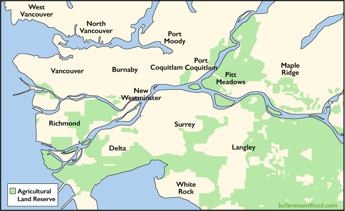
Pretty much everything in between the ALR and parkland in East Maple Ridge is empty suburbs. And even the ALR there has less than a 75% usage rate. It's basically just forest.


It's possible to open it up, (my 'mater plan' had a 'Golden Ears Bypass' running on the Golden Ears Way) but it would almost certainly mean destroying quite a bit of single-family homes, dividing Maple Ridge into 2 pieces, and has a good chance of ending the same way as the NFPR due to opposition.


Without freeway access, that land is going to remain locked up for good, because driving that far out on current roads is a joke, and so is transit that far out, in undeveloped land (it also gets steep as you get towards Alouette and Stave Lake).


Abbostford also has more land, but it's basically still limited to the land on Sumas Mountain, which would likely be filled up in 20-30 years. Even that's halved because of steep slopes on Sumas Mountain.

Vedder Mountain is probably too steep, except on its lowest slopes, which are also filling up. Even this is a 1h, 30 min commute by car.

Squamish seems to have a decent amount of Greenfield land- assuming Cheakamus 11 is open for development.

Last edited by fredinno; Nov 27, 2018 at 8:38 AM.
Reply With Quote
     
     
  #231  
Old Posted Nov 27, 2018, 9:53 PM
LeftCoaster's Avatar
LeftCoaster LeftCoaster is offline
Moderator
 
Join Date: Nov 2005
Location: Toroncouver
Posts: 12,634
Quote:
Originally Posted by fredinno View Post
No, that ruins the point of the ALR- to protect agricultural land. Also, there are better uses to reserve that land for than residential sprawl.
But you'd be creating new ALR land on the sunshine coast, which as the name implies is also very good growing land.

You'd come out the same net-net in ALR land but the residential sprawl that would end up in the sunshine coast would end up somewhere far more easy to serve via transit in the lower mainland.
Reply With Quote
     
     
  #232  
Old Posted Nov 27, 2018, 11:07 PM
fredinno's Avatar
fredinno fredinno is offline
Registered User
 
Join Date: Jan 2012
Posts: 2,317
Quote:
Originally Posted by LeftCoaster View Post
But you'd be creating new ALR land on the sunshine coast, which as the name implies is also very good growing land.

You'd come out the same net-net in ALR land but the residential sprawl that would end up in the sunshine coast would end up somewhere far more easy to serve via transit in the lower mainland.
That's not why it was named the Sunshine Coast...
https://www.seniorsnews.com.au/news/...-from/2753474/

Quote:
It gave the district 'a great start in developing a tourist industry'; 'Sunshine', signifying 'brightness and warmth' (and providing a complementary attraction to the Gold Coast).
Honestly, the issue with 'moving' the patches of ALR land close-in is that you're moving high-usage, high fertility agricultural land in the Fraser Valley, to lower-fertility, partially subdivided land outside it.

Langley and Maple Ridge have the same problem of the lots being too subdivided, and despite the ALR's efforts, in places like the Salmon River Uplands, it's still way too subdivided to do any meaningful agriculture.

It's the same problem with 'moving' ALR land in general. Usually the areas 'compensated' by 'moving' the ALR aren't possible to be used for farming for one reason or another.

Here is an example:

Langley tried to pitch this proposal to the ALR so that it could consolidate the fragmented acres of development land in the Salmon River Uplands, and South Brookswood.

However, in reality, most of that land 'given' to the ALR is already semi-suburban (like Forest Knolls and Milner), or parkland, resulting in a net loss of actual farmable land, and the ALR rejected the proposal.

(Honestly, this if OT, but if I was running the ALR, I would just take the L, and give the Salmon River Highlands to for Langley to develop- the current situation means there's very few amenities, nor possibilities to densify the area to medium-density. It would also be possible to connect it to the Expo by a future extension past Langley Centre. Meanwhile, no one wants to form on the land, because everyone expects it to be parcelled out of the ALR at some point because of its highly-subdivided nature.)


If you want to prevent sprawl into the Sunshine Coast, just don't build the bridge.
Reply With Quote
     
     
  #233  
Old Posted Nov 27, 2018, 11:12 PM
milomilo milomilo is offline
Registered User
 
Join Date: Dec 2013
Location: Calgary
Posts: 10,499
You might want to read that article a little better!
Reply With Quote
     
     
  #234  
Old Posted Nov 27, 2018, 11:55 PM
Migrant_Coconut's Avatar
Migrant_Coconut Migrant_Coconut is offline
Registered User
 
Join Date: Oct 2015
Location: Kitsilano/Fairview
Posts: 8,396
Quote:
Originally Posted by milomilo View Post
You might want to read that article a little better!
Sunshine Coast, Queensland or Sunshine Coast, BC, it probably wasn't named by the farmers.
Reply With Quote
     
     
  #235  
Old Posted Nov 28, 2018, 12:40 AM
logan5's Avatar
logan5 logan5 is offline
Registered User
 
Join Date: Feb 2011
Location: Mt.Pleasant
Posts: 6,865
How about this plan... Sell Bowen Island to private developers where they can then clearcut and flatten Bowen Island. Award the developers downtown level densities, the proceeds from which a bridge to the mainland could be built to serve a new hyper suburb of 1 million people.

Oh yeah, and a nice seawall.
Reply With Quote
     
     
  #236  
Old Posted Nov 28, 2018, 2:02 AM
VancouverOfTheFuture's Avatar
VancouverOfTheFuture VancouverOfTheFuture is offline
Registered User
 
Join Date: Apr 2014
Posts: 3,279
Quote:
Originally Posted by logan5 View Post
How about this plan... Sell Bowen Island to private developers where they can then clearcut and flatten Bowen Island. Award the developers downtown level densities, the proceeds from which a bridge to the mainland could be built to serve a new hyper suburb of 1 million people.

Oh yeah, and a nice seawall.
i read that as sarcasm, but with the internet, you never know...
Reply With Quote
     
     
  #237  
Old Posted Nov 28, 2018, 7:27 PM
LeftCoaster's Avatar
LeftCoaster LeftCoaster is offline
Moderator
 
Join Date: Nov 2005
Location: Toroncouver
Posts: 12,634
Quote:
Originally Posted by fredinno View Post
That's not why it was named the Sunshine Coast...
https://www.seniorsnews.com.au/news/...-from/2753474/

Honestly, the issue with 'moving' the patches of ALR land close-in is that you're moving high-usage, high fertility agricultural land in the Fraser Valley, to lower-fertility, partially subdivided land outside it.
As other's have pointed out, that's the sunshine coast in Australia.

I have no idea why the one in BC us actually named that way, my post was mainly just making light of the name to point out that the sunshine coast does in fact more sun than the valley. So while the valley may have better soil the coast gets more sun. Now I'm no farmer, so I don't know which is preferred, but the sunshine coast is hardly poor ALR land.

Regarding subdivison, In order to move the ALR, land owners would need to be purchased out anyway so the province would need to purchase out both sets of land at current market rates, then change the designation, then sell them off. Any net change in value would be attributable to the province, be it profit or loss. When this transaction occurs any existing subdivision in the new ALR lands in the sunshine coast could be removed and the new development lands in the lower mainland could be subdivided and rezoned as appropriate.
Reply With Quote
     
     
  #238  
Old Posted Nov 28, 2018, 9:50 PM
fredinno's Avatar
fredinno fredinno is offline
Registered User
 
Join Date: Jan 2012
Posts: 2,317
Quote:
Originally Posted by LeftCoaster View Post
As other's have pointed out, that's the sunshine coast in Australia.

I have no idea why the one in BC us actually named that way, my post was mainly just making light of the name to point out that the sunshine coast does in fact more sun than the valley. So while the valley may have better soil the coast gets more sun. Now I'm no farmer, so I don't know which is preferred, but the sunshine coast is hardly poor ALR land.

Regarding subdivison, In order to move the ALR, land owners would need to be purchased out anyway so the province would need to purchase out both sets of land at current market rates, then change the designation, then sell them off. Any net change in value would be attributable to the province, be it profit or loss. When this transaction occurs any existing subdivision in the new ALR lands in the sunshine coast could be removed and the new development lands in the lower mainland could be subdivided and rezoned as appropriate.


Yeah, I skimmed that article, I should have read it more thoroughly.

Technically, they could, but


1. I doubt that land is ever going to be more fertile than the hyper-fertile plains of Richmond and Delta. Especially since the geography is comparable to the North Shore. Was agriculture ever a big thing there?

2. You're assuming the province would be interested enough in this sort of land buyout and consolidation (the current crown lands are generally marginal for farming) to buy it all.

3. The ALR land left close to Vancouver is mostly on the floodplain lowlands, so is much more vulnerable to climate change- in fact, most of it is at or just below sea level).

4. The ALR land can be used as a land reserve to build land-intensive things like parks, and industrial land if we run out- basically, rationing land for the future. Cities like Busan have this problem, where there's literally no flat land left.

5. It's not like no one lives in these parcels already.


The province 'gave' a lot of land to the ALR in the Peace River Area over the years, only to turn out that 60% was completely useless for farming.

https://blogs.ubc.ca/amygiscience/20...ace-river-alr/
Reply With Quote
     
     
  #239  
Old Posted Dec 1, 2018, 3:44 AM
Tetsuo Tetsuo is offline
Registered User
 
Join Date: Oct 2013
Posts: 1,382
Question I always wanted to ask:

Being close to Metro Van, why is Gambier Island a lot less developed than other islands (Salt Spring, Bowen) & the sunshine coast?

Is it due to the island's geography?
Reply With Quote
     
     
  #240  
Old Posted Dec 1, 2018, 5:21 PM
fredinno's Avatar
fredinno fredinno is offline
Registered User
 
Join Date: Jan 2012
Posts: 2,317
Quote:
Originally Posted by Tetsuo View Post
Question I always wanted to ask:

Being close to Metro Van, why is Gambier Island a lot less developed than other islands (Salt Spring, Bowen) & the sunshine coast?

Is it due to the island's geography?
Probably- I mean, 5/6ths of the island are too rugged to effectively build on.
Reply With Quote
     
     
This discussion thread continues

Use the page links to the lower-right to go to the next page for additional posts
 
 
Reply

Go Back   SkyscraperPage Forum > Regional Sections > Canada > Alberta & British Columbia > Vancouver > Transportation & Infrastructure
Forum Jump


Forum Jump


All times are GMT. The time now is 1:28 AM.

     
SkyscraperPage.com - Archive - Privacy Statement - Top

Powered by vBulletin® Version 3.8.7
Copyright ©2000 - 2024, vBulletin Solutions, Inc.