HomeDiagramsDatabaseMapsForum About
     

Go Back   SkyscraperPage Forum > Regional Sections > Canada > Ontario > Ottawa-Gatineau > Transportation


Reply

 
Thread Tools Display Modes
     
     
  #1  
Old Posted Feb 1, 2015, 4:02 PM
ACmodels's Avatar
ACmodels ACmodels is offline
Registered User
 
Join Date: Nov 2014
Location: NCR
Posts: 123
Airport Rail Link

I think it's about time that the airport rail link should be it's own thread by now. So I tool the liberties to do that. With this thread we can share our plans, stories and other stuff for rail to the Ottawa Airport.

And then at the end of the month once all of the maps are done and people have seen and talked about them, I may out up a poll up and you can vote foe who's plan is the best! Your prize can be knowing that people on the forum like your plan and wish that it could be build!
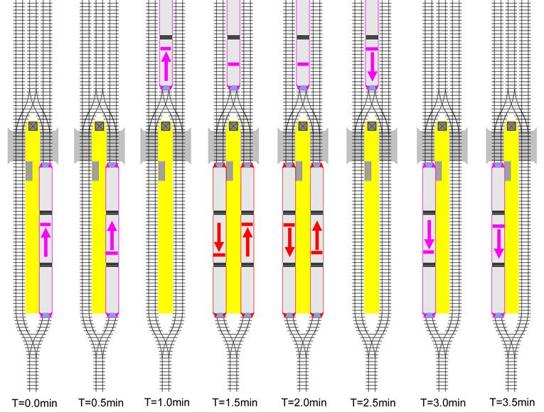
City's plan:


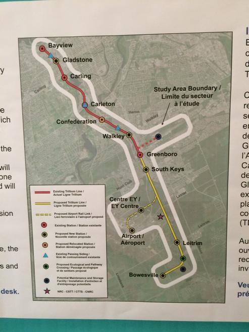
http://documents.ottawa.ca/sites/doc..._boards_en.pdf

My plan (ACmodels):

My plan has a PRT (Personal Rapid Transit)

There would be a PRT link to the airport from the EY Center. Kinda like Hearthow's PRT to a parking lot. With my PRT when you arrive at the airport you don't have to wait for a train you can just pay with PRESTO or credit card or cash to use the PRT and get right on to the EY Center. Once you get to the EY center you would be in a fare paid zone so you don't have to tap or show POP or you can continue your ride to the Hilton Hotel. At the EY center Station. I would have something like this:

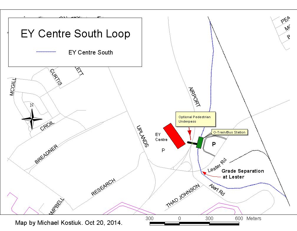
Minus the Bus Station. Trillium Line Trains going to RS (Riverside South) and Bayview will have to stop on the EY center loop to pick up passengers from the PRT. Only people going to the Airport have to make a transfer. There would only have to be one (1) Grade Separated crossing over the airport parkway to reach the EY Center Station. While at Research Rd and Uplands Drive it can be At-Grade since PRT is only Battery powered and not Big diesel trains.

Richard Eade's plan:


NOTE: All pictures bellow are made my Richard Eade and are not mine.

OK, here’s a different approach:
since there seems to be a need to grade separate diesel trains but not electric trains, and since the original LRT plan for Riverside South was based on electric trains, and since the south will get a shuttle train to South Keys most of the day, then why not just building the extension from South Keys Station into Riverside South as electric LRT?

The basic idea would be this:

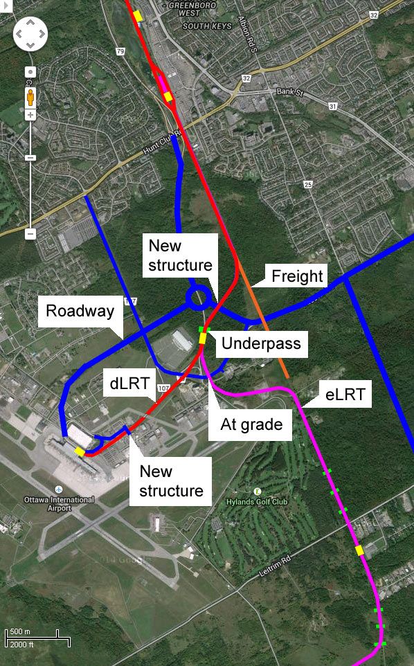
Admittedly, I have made some other changes, specifically re-aligning Lester and the Airport Parkway north (which is where the Parkway is planned to go in the future). I figured that it is probably cheaper to build the road along the north than the diesel tracks (and associated structures) and the road would support a new road network to develop those lands. A diesel train track would provide nothing but a barrier for development.

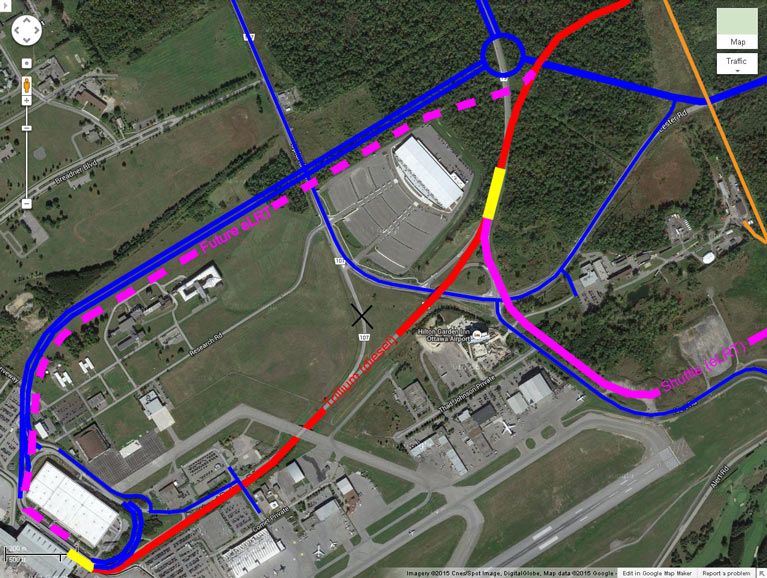
However, I would like to get the train to the airport so I have run it (relatively inexpensively) along the existing Parkway infrastructure. There is only the need for a small overpass so cars can get to Airbus Private. This would be a temporary train route and when the line is converted to electric, the new electric tracks can be built beside the re-aligned Parkway where it would co-exist with the road network. During that construction, the diesel train would continue serving the airport.


In the meantime, the Riverside South area would be served by an electric LRT which would shuttle passengers to South Keys Station – much as the # 99 bus does today. The big difference is that trains can be timed much better than bus buses seem to be. With proper timing, the transfer could go something like this:


Where north-bound passengers alight from the shuttle and wait for the shuttle to get out of the way before the north-bound (diesel) train arrives. At the same time (remember, the north and south trains will pass at South Keys) the south-bound passengers exit their diesel train and wait for the shuttle to come along momentarily. Transfers exist, but they are very fast.

A benefit of using electric LRT right from the start is that the shuttle can easily be extended along the original corridor through Riverside South as money permits. If the Riverside South train is diesel, then it will need to wait until the line is converted to electricity or there will need to be a lot more overpasses – so it would be impractical to extend the diesel train.

A draw-back is that there are two different technologies that need to be serviced. However, if the same electric trains are used for Riverside South as for the Confederation Line (they probably ordered lots of spares for future growth, or have an option to order more), then some of those electric trains can simply be pushed between the Belfast Yard for maintenance and Riverside South. (There is a rail link between the Walkley Yard and the VIA track that abuts the Belfast Yard.) The Diesel trains would still be maintained at Walkley Yard which might not need to be expanded to handle a lot more vehicles. (Probably only one or two extra diesel trains are needed to serve the airport, but if both branches are done with diesel, then the fleet will likely more than double.) Alternatively, the City is planning to open the Bowesville Yard if the Trillium Line extension requires too many diesel trains to be handled at Walkley. If Bowesville Yard needs to be opened, maybe it can be built smaller to just handle the electric trains needed for the shuttle and the diesels can remain at Walkley.

---------------------------------------------------------------------------------------------------------------------------------------------------------------------------------------------------

Hers's a neat report: http://www.queensu.ca/surp/sites/web...013-14comp.pdf

Last edited by ACmodels; Feb 1, 2015 at 6:51 PM.
Reply With Quote
     
     
  #2  
Old Posted Feb 1, 2015, 4:34 PM
ACmodels's Avatar
ACmodels ACmodels is offline
Registered User
 
Join Date: Nov 2014
Location: NCR
Posts: 123

uh I don't know why it's small....

Last edited by ACmodels; Feb 1, 2015 at 5:32 PM.
Reply With Quote
     
     
  #3  
Old Posted Feb 1, 2015, 5:09 PM
eternallyme eternallyme is offline
Registered User
 
Join Date: Mar 2009
Posts: 5,243
Here is a possible alternative I came up with:


Colour legend:

Purple - Possible surface urban LRT (i.e. with grade crossings)
Blue - Elevated
Green - Protected ROW at surface
Yellow - Trenched
Orange - Cut and cover tunnel (none in this plan)
Red - Bored tunnel

PROS:
* Allows direct airport access in both directions
* More frequent service, direct, to the airport
* Service to north Riverside South (closer to Leitrim)
* Less "dead space" served leading to higher ridership
* Lower short term costs as the section south of the NRC building does not need to be built (and no station at Bowesville or Leitrim), and the airport station can be staged
* Can be staged efficiently, as the airport station location would move about 250m westward later (the initial pathway can be climate controlled).

CONS
* Higher longer term costs due to boring a tunnel under the airport
* No service to the existing Leitrim Park and Ride - the lower Bank Street corridor will be farther from rapid transit (i.e. Lester or Limebank/Leitrim)
* The initial airport station becomes throw-away at second stage (when it goes into the tunnel)
Reply With Quote
     
     
  #4  
Old Posted Feb 9, 2015, 8:19 PM
swimmer_spe swimmer_spe is offline
BANNED
 
Join Date: Apr 2014
Posts: 10,738
Why not do both?
Why not have the Airport be a transfer point?

What may make more sense is have a line run outside the Greenbelt that connects to the Trillium Line at the Airport.

The GreenBelt line could run from Leitrim to Riverview. and then be extended east and west. This would provide excellent service from downtown to the Airport, and also cover those points.
Reply With Quote
     
     
  #5  
Old Posted Feb 9, 2015, 9:04 PM
ACmodels's Avatar
ACmodels ACmodels is offline
Registered User
 
Join Date: Nov 2014
Location: NCR
Posts: 123
Quote:
Originally Posted by swimmer_spe View Post
Why not do both?
Why not have the Airport be a transfer point?

What may make more sense is have a line run outside the Greenbelt that connects to the Trillium Line at the Airport.

The GreenBelt line could run from Leitrim to Riverview. and then be extended east and west. This would provide excellent service from downtown to the Airport, and also cover those points.
Do you have a map? I have a hard time understanding this? Sorry...
Reply With Quote
     
     
  #6  
Old Posted Feb 9, 2015, 10:54 PM
swimmer_spe swimmer_spe is offline
BANNED
 
Join Date: Apr 2014
Posts: 10,738
Quote:
Originally Posted by ACmodels View Post
Do you have a map? I have a hard time understanding this? Sorry...
What free software is out that that would allow me to show you?
Reply With Quote
     
     
  #7  
Old Posted Feb 9, 2015, 11:14 PM
ACmodels's Avatar
ACmodels ACmodels is offline
Registered User
 
Join Date: Nov 2014
Location: NCR
Posts: 123
Quote:
Originally Posted by swimmer_spe View Post
What free software is out that that would allow me to show you?
uh adobe photo shop er ask the guys who make the maps above??? sorry thats what im trying to figure out too?
Reply With Quote
     
     
  #8  
Old Posted Feb 9, 2015, 11:18 PM
citydwlr citydwlr is offline
Registered User
 
Join Date: Mar 2013
Posts: 725
Quote:
Originally Posted by swimmer_spe View Post
What free software is out that that would allow me to show you?
I'm not sure if this is what you are looking for, but GIMP is a free photoshop-like software that many people swear by:

http://www.gimp.org/

I personally do not have experience with this software, but I hear it mentioned quite a bit.
Reply With Quote
     
     
  #9  
Old Posted Feb 9, 2015, 11:23 PM
waterloowarrior's Avatar
waterloowarrior waterloowarrior is offline
National Capital Region
 
Join Date: Nov 2005
Location: Eastern Ontario
Posts: 9,244
I find Google's My Maps tool pretty handy for quick maps.
https://www.google.com/mymaps
Reply With Quote
     
     
  #10  
Old Posted Feb 10, 2015, 3:16 AM
Buggys Buggys is offline
Registered User
 
Join Date: Dec 2012
Location: Ottawa
Posts: 659
Or for a really low tech option, just go print-screen a map, and draw rough lines in MS Paint.
Reply With Quote
     
     
  #11  
Old Posted Feb 10, 2015, 3:26 AM
danishh danishh is offline
Registered User
 
Join Date: Dec 2013
Posts: 427
i'm kind of ok just doing an airport spur and eventually turning that spur into the southern terminus of the bank street subway. Yes I know that would take 50 years.
Reply With Quote
     
     
  #12  
Old Posted Feb 10, 2015, 5:42 AM
swimmer_spe swimmer_spe is offline
BANNED
 
Join Date: Apr 2014
Posts: 10,738
Quote:
Originally Posted by waterloowarrior View Post
I find Google's My Maps tool pretty handy for quick maps.
https://www.google.com/mymaps
Google is shutting that down shortly.
Reply With Quote
     
     
  #13  
Old Posted Feb 10, 2015, 9:33 PM
swimmer_spe swimmer_spe is offline
BANNED
 
Join Date: Apr 2014
Posts: 10,738
Quote:
Originally Posted by ACmodels View Post
Do you have a map? I have a hard time understanding this? Sorry...
https://www.google.com/maps/d/edit?m...c.kvxRMv4GxUiQ

Here is a rough idea.

Yes, parts of it would have a long distance between some stations due to the lack of anything in the area. However, If the line was there, it may draw growth. The exact routing could be figured out, but, by having the GreenBelt line, it would act as a partial ring, it would connect those places outside the Greenbelt, and it would pave the way for future development.
Reply With Quote
     
     
  #14  
Old Posted Feb 10, 2015, 10:27 PM
ACmodels's Avatar
ACmodels ACmodels is offline
Registered User
 
Join Date: Nov 2014
Location: NCR
Posts: 123
Quote:
Originally Posted by swimmer_spe View Post
https://www.google.com/maps/d/edit?m...c.kvxRMv4GxUiQ

Here is a rough idea.

Yes, parts of it would have a long distance between some stations due to the lack of anything in the area. However, If the line was there, it may draw growth. The exact routing could be figured out, but, by having the GreenBelt line, it would act as a partial ring, it would connect those places outside the Greenbelt, and it would pave the way for future development.
ok now I get!!
Reply With Quote
     
     
  #15  
Old Posted Feb 10, 2015, 10:29 PM
swimmer_spe swimmer_spe is offline
BANNED
 
Join Date: Apr 2014
Posts: 10,738
Quote:
Originally Posted by ACmodels View Post
ok now I get!!
Like it?
Bad idea?
Reply With Quote
     
     
  #16  
Old Posted Feb 10, 2015, 11:26 PM
silvergate's Avatar
silvergate silvergate is offline
Registered User
 
Join Date: Apr 2014
Location: Ottawa
Posts: 629
Quote:
Originally Posted by swimmer_spe View Post
https://www.google.com/maps/d/edit?m...c.kvxRMv4GxUiQ

Here is a rough idea.

Yes, parts of it would have a long distance between some stations due to the lack of anything in the area. However, If the line was there, it may draw growth. The exact routing could be figured out, but, by having the GreenBelt line, it would act as a partial ring, it would connect those places outside the Greenbelt, and it would pave the way for future development.
I can't see this line being feasible without connection through the more central parts of Ottawa. Not to mention, is more sprawl really what we are trying to attract with transit?
Reply With Quote
     
     
  #17  
Old Posted Feb 10, 2015, 11:38 PM
ACmodels's Avatar
ACmodels ACmodels is offline
Registered User
 
Join Date: Nov 2014
Location: NCR
Posts: 123
Quote:
Originally Posted by swimmer_spe View Post
Like it?
Bad idea?
I'm Sorry but bad idea, but still a good concept!
Reply With Quote
     
     
  #18  
Old Posted Feb 10, 2015, 11:53 PM
ACmodels's Avatar
ACmodels ACmodels is offline
Registered User
 
Join Date: Nov 2014
Location: NCR
Posts: 123
I was wondering if the city has the money to build a airport rail line now for the 2017 150th anniversary?


I don't think so.....
Reply With Quote
     
     
  #19  
Old Posted Feb 11, 2015, 1:42 AM
swimmer_spe swimmer_spe is offline
BANNED
 
Join Date: Apr 2014
Posts: 10,738
Quote:
Originally Posted by silvergate View Post
I can't see this line being feasible without connection through the more central parts of Ottawa. Not to mention, is more sprawl really what we are trying to attract with transit?
Sprawl is going to happen whether we want it to happen or not. We can build for it to be done in an intelligent way, or we can let it happen and then try to figure out how to reduce congestion when it is too late.

There is already sprawl happening outside the Green Belt. We can mitigate the sprawl and mitigate the congestion, or we can let what happened in Toronto and Vancouver happen.

Also, if within 500m of a station is designated as Transit Oriented development where single family homes or low rise buildings were not permitted, development would complement the the line, and would reduce sprawl as well.
Reply With Quote
     
     
  #20  
Old Posted Feb 11, 2015, 1:49 AM
silvergate's Avatar
silvergate silvergate is offline
Registered User
 
Join Date: Apr 2014
Location: Ottawa
Posts: 629
Quote:
Originally Posted by swimmer_spe View Post
Sprawl is going to happen whether we want it to happen or not. We can build for it to be done in an intelligent way, or we can let it happen and then try to figure out how to reduce congestion when it is too late.

There is already sprawl happening outside the Green Belt. We can mitigate the sprawl and mitigate the congestion, or we can let what happened in Toronto and Vancouver happen.

Also, if within 500m of a station is designated as Transit Oriented development where single family homes or low rise buildings were not permitted, development would complement the the line, and would reduce sprawl as well.
I honestly think a better way to connect (part of) the suburbs is Baseline. They are building new transitways/dedicated bus lanes near Innes, and on Baseline. I can see a connection eventually being possible via Industrial-Hurdman-SE Transitway-Baseline-Robertson-Hazeldean.
That's Orleans to Kanata, with connection to both light-rail lines. I like the idea of being able to move people outside the core, but it's not clear whether demand will ever exist enough to justify a line that completely skips central Ottawa.
I could see the Greenbelt line being a useful thing IF Kanata developed into more of a city in its own right, with a strong core (one day, the tech revolution may return).
Reply With Quote
     
     
This discussion thread continues

Use the page links to the lower-right to go to the next page for additional posts
 
 
Reply

Go Back   SkyscraperPage Forum > Regional Sections > Canada > Ontario > Ottawa-Gatineau > Transportation
Forum Jump


Forum Jump


All times are GMT. The time now is 8:46 AM.

     
SkyscraperPage.com - Archive - Privacy Statement - Top

Powered by vBulletin® Version 3.8.7
Copyright ©2000 - 2024, vBulletin Solutions, Inc.