HomeDiagramsDatabaseMapsForum About
     

Go Back   SkyscraperPage Forum > Discussion Forums > City Discussions


Reply

 
Thread Tools Display Modes
     
     
  #141  
Old Posted Jun 20, 2012, 3:54 PM
nei nei is offline
Registered User
 
Join Date: Apr 2012
Posts: 515
Quote:
Originally Posted by Dralcoffin View Post
The smallest level for which I found density data in Moscow is the 125 districts (raioni) of the city, which are summarized in this table on the Russian Wikipedia, density in the sixth column. I can try and put a map of densities together, but the average density of a district is around 30,000 people per square mile with five of the 125 over 60,000 ppsm.
Looking forward to seeing the map. How many people in a district?

Quote:
Interestingly, there isn't much of a density buildup in the core, but rather the high density areas seem to be scattered in pockets around the city, likely reflecting the location of enormous Soviet housing projects.
The core isn't as dense because it was built earlier when the demand for housing was lower. Explanation is exactly as you said described in more detail here:

http://marketurbanism.com/2010/10/19...ialist-cities/
Reply With Quote
     
     
  #142  
Old Posted Jun 20, 2012, 4:01 PM
ChiSoxRox's Avatar
ChiSoxRox ChiSoxRox is offline
Registered User
 
Join Date: Mar 2007
Location: Boston, MA
Posts: 2,494
Quote:
Originally Posted by nei View Post
Looking forward to seeing the map. How many people in a district?
The average district population is right around 100,000. There likely is finer data, but my Russian isn't good enough to go wading through the Russian Census.

The city proper of Moscow in the 2010 Census had a population of 11,514,330 over an area of 421 square miles, so a density of 27,335 people per square mile. While that is a similar density to New York overall, just eyeballing the data, Moscow's density seems more evenly spread out than the sharp dropoff as you leave Manhattan, and indeed seems to peak a little farther out right in line with your link. I'll see how quickly I can get a map together and see how well that instinct turns out.

Edit: I might have the map done later tonight. Getting a map isn't hard; here's the one I'll use: a svg off Wikimedia Commons. But matching up the 125 districts will take some time.
__________________
Like the pre-war masonry skyscrapers? Then check out my list of the tallest buildings in 1950.

Last edited by ChiSoxRox; Jun 20, 2012 at 4:13 PM.
Reply With Quote
     
     
  #143  
Old Posted Jun 20, 2012, 10:13 PM
memph memph is offline
Registered User
 
Join Date: Dec 2010
Posts: 1,854
Quote:
Originally Posted by CyberEric View Post
Yeah, I think a lot of people think that London is closer to NYC than it actually is, including Boris Johnson when he went a little provential in his recent interview with Charlie Rose.


Yeah, they are terrible for many, many reasons.


Which neighbourhood are you referring to? I was just in Barcelona and it's amazing how dense it is compared to London.
Can Mariner in Santa Coloma de Gramenet: http://goo.gl/maps/WSGP

It has 8,267 inhabitants and a density of 214,193 ppsm.

The next densest neighbourhood in the Barcelona area is La Florida in L'Hospitalet de Llobregat at 199,987 ppsm with 29,183 inhabitants.

Quote:
Technically, the UES is more tenements/ walk-up apartments together with high rises. The more espensiv western part of the UES has more rowhouses but not as many high rises. This things aren't much lower in density than Upper Manhattan / West Bronx buildings:
Alright, I guess it's more apartments, but still low-mid rise. I didn't mean to make it sounds like the UES was less dense than Upper Manhattan and the West Bronx, I just wanted to get across that the UES is not especially denser than parts of Upper Manhattan/West Bronx that are 5-8s tenements.
Reply With Quote
     
     
  #144  
Old Posted Jun 20, 2012, 11:36 PM
memph memph is offline
Registered User
 
Join Date: Dec 2010
Posts: 1,854
Quote:
Originally Posted by Crawford View Post
I'd say there are quite a few predominantly highrise residental census tracts in NYC.

Your characterization of the Upper East Side isn't really correct. The UES is primarily mid- and highrise residential. It has relatively few townhouses/rowhouses, especially east of Lexington Avenue (which is the vast majority of the UES).

Even off the avenues, apartments dominate on the UES, and east of Lexington, mid- and highrise apartments are common on the side streets. This is, by far, the densest part of the UES (east of Lex).

And, while the Upper West Side has more townhouses than the UES, they're definitely in the minority. The UWS is primarily mid- and highrise, like the UES, though the ratio of midrise is higher than on the UES.

There's various other primarily residential highrise tracts in Manhattan, such as parts of Chelsea, East Side from 14th Street through Midtown, far East Harlem, Hudson Yards, Turtle Bay/Sutton Place, Battery Park City, waterfront Lower East Side and Roosevelt Island.

Then, in the boroughs, there's Co-op City, Spring Creek/Starrett City, Rochdale Village, Lefrak City, Parkchester, and various public and Mitchell-Lama (subsidized middle income) housing complexes.
I guess there are some predominantly high rise residential CTs (census tracts), but then they're mostly towers in the park style, which means the density ends up being not that high. In order to get really high density CTs with high rises, they need to be close together, not towers in the park.

I can only find city blocks that would qualify, but census tracts typically need several city blocks to have high enough populations. Also when I mean predominantly high rise, I mean in terms of the land area, not what kind of building most people live in. If there's a census tract with 4000 people living in high rises that occupy 20% of the land and 2000 people living in low-mid rises occupying 80% of the land, that's not what I'm talking about.

Chelsea: Densest CT is the one with London Terrace Gardens, and although the city block it is in is totally highrise residential, the CT has 7 other city blocks which are mostly low-midrise or towers in the park.

East Side, 14th-Midtown: A lot of those are towers in the park. The densest CT is in Kips Bay, but that's kind of tower in the park style, and there are also low-midrise buildings along the streets.

Sutton Place: It is primarly residential, not tower in the park and there are only a couple blocks with low-midrises. Still the density is not as high as you'd expect (146,000 ppsm). Probably the units are quite spacious and the highrises are also not that tall, most are 12-20 stories. I suppose it meets my criteria, but the density is not really higher than the denser midrise tenement neighbourhoods.

East Harlem and Lower East Side Waterfront: towers in the park, so the resultant density is not that high

Hudson Yards: Maybe, but it's not yet built, and I think the commercial component will be a bit larger than the residential one, so the density might not end up that high.

Roosevelt Island: Much of it is a hospital and unbuilt land, a lot of the buildings are more midrise too.

Battery Park City: A lot of midrises, the census tract is only 57,000 ppsm. I'm not too familiar with the project, but I wonder if there's also a substantial amount of commercial space?

Boroughs: All tower in the park.

My point is that the high rise areas of Manhattan do not have a much higher population density (if it's higher at all) than the midrise parts, even though they could be. There is a proposal to develop a city block in Toronto that's currently a grocery store and car dealership, it would have two 34s slab towers with a 13-17s base, bisected by small new street. Assuming 1.5 residents per unit (Downtown Toronto average), the city block would have a density of 400,000 ppsm measured to the middle of the street.

http://urbantoronto.ca/forum/showthr...arini%29/page8

They'll probably be forced to scale it down, but in these kinds of cases, the approved density still ends up being quite high. Two other blocks are set to see about the same density of development in the form of multiple developments that probably will be (or have been) approved at the proposed density. And a lot of city blocks have already been built out at a density of 200-300k ppsm. Although those don't have their own census tract, it does help give an idea for how dense you can go with highrises.
Reply With Quote
     
     
  #145  
Old Posted Jun 20, 2012, 11:57 PM
nei nei is offline
Registered User
 
Join Date: Apr 2012
Posts: 515
Quote:
Originally Posted by memph View Post
Sutton Place: It is primarly residential, not tower in the park and there are only a couple blocks with low-midrises. Still the density is not as high as you'd expect (146,000 ppsm). Probably the units are quite spacious and the highrises are also not that tall, most are 12-20 stories. I suppose it meets my criteria, but the density is not really higher than the denser midrise tenement neighbourhoods.
Sutton Place is one of the wealthiest spots in the city. Units are definitely spacious. From photos it looked like a lot was around 5 stories.

Quote:
East Harlem and Lower East Side Waterfront: towers in the park, so the resultant density is not that high
And most of that is public housing projects. Public housing in NYC tends to have more space between buildings than private towers in the park. East Harlem has one of the highest concentration of public housing in the city, and likely the nation after Chicago tore its projects down.

Quote:
Roosevelt Island: Much of it is a hospital and unbuilt land, a lot of the buildings are more midrise too.
The residential components look quite dense, but I doubt anymore than a typical Manhattan neighborhood.

Quote:
Battery Park City: A lot of midrises, the census tract is only 57,000 ppsm. I'm not too familiar with the project, but I wonder if there's also a substantial amount of commercial space?
It's government built (on landfill from the digging up the foundations to the World Trade Center) but market rate. A public park was incorporated within and on the edge are office buildings (World Financial Center). It's meant to be self-contained with its own stores.

Quote:
Boroughs: All tower in the park.
Lefrak City is one of the densest tracts in the city, dunno if it counts as tower in the park.

Quote:
My point is that the high rise areas of Manhattan do not have a much higher population density (if it's higher at all) than the midrise parts, even though they could be. There is a proposal to develop a city block in Toronto that's currently a grocery store and car dealership, it would have two 34s slab towers with a 13-17s base, bisected by small new street. Assuming 1.5 residents per unit (Downtown Toronto average), the city block would have a density of 400,000 ppsm measured to the middle of the street.
Manhattan's density seem to be rather flat; regardless of housing style, the density is similar (you can see that from the graph I posted earlier in the thread):

http://forum.skyscraperpage.com/show...6&postcount=74

the lowest densities are mostly from business districts as well as from partially undeveloped waterfront land.

Did you ever calculate the weighted density of NYC or the NYC metro from the 2010 census?

Last edited by nei; Jun 21, 2012 at 12:19 AM.
Reply With Quote
     
     
  #146  
Old Posted Jun 21, 2012, 12:56 AM
ChiSoxRox's Avatar
ChiSoxRox ChiSoxRox is offline
Registered User
 
Join Date: Mar 2007
Location: Boston, MA
Posts: 2,494
Moscow's density map:


(To get people per square mile, multiply by 2.59.)

The four densest districts are in purple, and you can see that the densest areas are towards the city limits, and bunched to the south and north. The area towards the Moscow River, which winds its way from about ten o'clock to five o'clock, tends to be industrial.
__________________
Like the pre-war masonry skyscrapers? Then check out my list of the tallest buildings in 1950.

Last edited by ChiSoxRox; Jun 21, 2012 at 1:10 AM.
Reply With Quote
     
     
  #147  
Old Posted Jun 21, 2012, 4:22 AM
memph memph is offline
Registered User
 
Join Date: Dec 2010
Posts: 1,854
Quote:
Originally Posted by nei View Post
Lefrak City is one of the densest tracts in the city, dunno if it counts as tower in the park.
Well... at the very least it is based on the radiant city model. It is the densest tract in NYC, just like St James Town (also radiant city style) is the densest in Toronto for now.


Quote:
Originally Posted by nei View Post
Did you ever calculate the weighted density of NYC or the NYC metro from the 2010 census?
Yeah, not too long ago, along with Atlanta and San Jose.

New York UA
2010: 31,470 ppsm (18,777,859)
2000: 33,029 ppsm (17,799,861)

New York City
2010: 61,329 ppsm (8,190,162)
2000: 64,025 ppsm (8,008,278)

Atlanta UA
2010: 2,417 ppsm (4,708,426)
2000: 2,362 ppsm (3,499,840)

San Jose UA
2010: 8,953 ppsm (1,667,332)
2000: 8,766 ppsm (1,538,312)

The drop in NYC was a bit unexpected... the only explanation is that many of the densest parts lost population while most of the population gain was in lower density parts of the city. This could be brownfields, Downtown/Midtown, maybe outer areas of the boroughs?
Reply With Quote
     
     
  #148  
Old Posted Jun 21, 2012, 5:25 AM
Jelly Roll Jelly Roll is offline
Registered User
 
Join Date: Sep 2011
Location: Philadelphia
Posts: 1,314
Quote:
Originally Posted by memph View Post
Well... at the very least it is based on the radiant city model. It is the densest tract in NYC, just like St James Town (also radiant city style) is the densest in Toronto for now.


Yeah, not too long ago, along with Atlanta and San Jose.

New York UA
2010: 31,470 ppsm (18,777,859)
2000: 33,029 ppsm (17,799,861)

New York City
2010: 61,329 ppsm (8,190,162)
2000: 64,025 ppsm (8,008,278)

Atlanta UA
2010: 2,417 ppsm (4,708,426)
2000: 2,362 ppsm (3,499,840)

San Jose UA
2010: 8,953 ppsm (1,667,332)
2000: 8,766 ppsm (1,538,312)

The drop in NYC was a bit unexpected... the only explanation is that many of the densest parts lost population while most of the population gain was in lower density parts of the city. This could be brownfields, Downtown/Midtown, maybe outer areas of the boroughs?
No, the loss of population density is the fact that Manhattan has almost 50%+ of its housing units occupied by 1 person. Manhattan is the only place that is losing density per mile in NYC. The reason for this is that more families used to live in Manhattan and now more single people live there.
Reply With Quote
     
     
  #149  
Old Posted Jun 21, 2012, 1:41 PM
Crawford Crawford is offline
Registered User
 
Join Date: Nov 2003
Location: Brooklyn, NYC/Polanco, DF
Posts: 30,757
Quote:
Originally Posted by Jelly Roll View Post
No, the loss of population density is the fact that Manhattan has almost 50%+ of its housing units occupied by 1 person. Manhattan is the only place that is losing density per mile in NYC. The reason for this is that more families used to live in Manhattan and now more single people live there.
I don't think this is true.

Manhattan's average household size is increasing, not decreasing.

In particular, the proportion of children is rising, as a higher proportion of families choose to raise their kids in the city. The number of Manhattan children under the age of 10 has soared in recent years.

Overall unit count is decreasing in many parts of Manhattan, though, because there have been so many apartment combinations.

Many older buildings had their huge prewar units chopped up beginning in the Great Depression, and moreso during the 50's through the 70's. Those buildings are steadily getting their grand apartments back, as folks combine adjacent units.

And buildings of a more recent vintage (say 70's through the early 90's) had a ton of smaller units, which have steadily been combined, as more families buy into these buildings. So you have formerly 200 unit unit highrises that now have 150 units or even fewer, though more residents per unit (but overall fewer residents in the building).

Extreme examples are in the wealthiest parts of Manhattan. Many of those grand prewars along Fifth Ave., Park Ave. or Central Park West have very few apartments. There are 20-floor buildings with 12 units. These are huge apartments.
Reply With Quote
     
     
  #150  
Old Posted Sep 14, 2012, 5:00 AM
Chicago103's Avatar
Chicago103 Chicago103 is offline
Future Mayor of Chicago
 
Join Date: Mar 2003
Location: Chicago
Posts: 6,060
I noticed something on google earth about the dimensions of typical residential blocks in Chicago vs. New York City, most importantly the width of those blocks. In Chicago the blocks have a width of 330 feet (1/16th mile) and in New York City they have a width of 264 feet (1/20th mile), in other words the backs of the houses and buildings are closer together in NYC than in Chicago, no doubt a large part of this is due to the lack of alleys. This is another reason for the greater density in NYC, you can have identical housing types, even the same number of houses on a block (or same number of housing units on X feet of street frontage) but because the width between blocks is less the density would be 1.25 times that of Chicago. So a 10,000 people per square mile block by block pattern in Chicago (mostly single family detached bungalows) would be 12,500 per square mile in New York City with identical types of housing. A 20,000 per square mile block by block pattern in Chicago would be 25,000 per square mile in New York City. I have always wondered how NYC neighborhoods managed to be denser than Chicago even when the type of buildings were virtually the same, this is a big part of the reason no doubt.
__________________
Devout Chicagoan, political moderate and paleo-urbanist.

"Auto-centric suburban sprawl is the devil physically manifesting himself in the built environment."

Last edited by Chicago103; Sep 15, 2012 at 5:36 AM.
Reply With Quote
     
     
  #151  
Old Posted Sep 14, 2012, 3:09 PM
Steely Dan's Avatar
Steely Dan Steely Dan is offline
devout Pizzatarian
 
Join Date: Jul 2001
Location: Lincoln Square, Chicago
Posts: 29,804
^ it's not just alleys. chicago hoods tend to have wider street ROW's, larger front yard set-backs, parkways, etc. things that tend to be smaller or non-existent in NYC. that's one of the reasons why a queens neighborhood with similar housing types to a given chicago neighborhood can still have nearly twice the density. there's just flat-out way more space in chicago. it's the difference between trying to cram as many people as possible onto an archipelago vs. a VAST unceasing plain stretching out from the shore of a lake for hundreds and hundreds of miles. there's just nowhere near the same preimium on space in chicago as there is on the islands of NYC.
__________________
"Missing middle" housing can be a great middle ground for many middle class families.
Reply With Quote
     
     
  #152  
Old Posted Sep 15, 2012, 5:55 AM
Chicago103's Avatar
Chicago103 Chicago103 is offline
Future Mayor of Chicago
 
Join Date: Mar 2003
Location: Chicago
Posts: 6,060
Quote:
Originally Posted by Steely Dan View Post
^ it's not just alleys. chicago hoods tend to have wider street ROW's, larger front yard set-backs, parkways, etc. things that tend to be smaller or non-existent in NYC. that's one of the reasons why a queens neighborhood with similar housing types to a given chicago neighborhood can still have nearly twice the density. there's just flat-out way more space in chicago. it's the difference between trying to cram as many people as possible onto an archipelago vs. a VAST unceasing plain stretching out from the shore of a lake for hundreds and hundreds of miles. there's just nowhere near the same preimium on space in chicago as there is on the islands of NYC.
Your right the lack of alleys and smaller front yard setbacks and fewer grass and tree lawns between the sidewalk and street are the reason that New York City blocks manage to be 64 feet shorter in width than blocks in Chicago. You are also right about the differences in geography. In New York City the density is a result of both proximity to Manhattan as well as the land constraints, the boroughs are either islands themselves (Manhattan, Staten Island), the relatively narrow western edge of Long Island (Brooklyn and Queens) or a narrow peninsula (Bronx) so the density is also a function of not only the tremendous demand but there literally being a finite amount of land to build on. In Chicago the level of density in the city and inner suburbs is a function of proximity to the Loop but not land constraints, the city limits of Chicago aside from the shore of Lake Michigan are pretty arbitrarily defined and the city never had to worry about running out of land to annex and build on and that is reflected in the urban density being a bit less dense relatively speaking.
__________________
Devout Chicagoan, political moderate and paleo-urbanist.

"Auto-centric suburban sprawl is the devil physically manifesting himself in the built environment."
Reply With Quote
     
     
  #153  
Old Posted Sep 15, 2012, 1:31 PM
dimondpark's Avatar
dimondpark dimondpark is offline
Pay it Forward
 
Join Date: Apr 2003
Location: Piedmont, California
Posts: 7,894
Quote:
Originally Posted by memph View Post
No, at least not yet. I did all of SF's urban area (doesn't not include Vallejo, Concord and Pleasanton areas, nor San Jose's MSA) since there is a fair bit of density outside SF proper in places like Oakland, Berkeley and Daly City.
This is a post of mine from a thread in another forum(C-D):
Quote:
It turns out that there are connected neighborhoods of 10,000ppsm+ extending all the way into San Leandro(3 neighborhoods connected to Oakland) and Albany(1 neighborhood connected to Berkeley) as well as about 2 dozen other Oakland neighborhoods that are connected to the former list of areas.

the area of 10,000+persons per square mile Extends over an area that is 18 Miles North to South from Downtown Albany to Farrelly Pond, San Leandro.


Here is the updated list of Oakland, Berkeley, San Leandro and Albany connected neighborhoods with a density of 10,000+ppsm

Neighborhood, City, Population Per Square Mile
Oak Tree Neighborhood, Oakland 34,447
Gold Coast Neighborhood, Oakland 29,212
Telegraph Ave neighborhood, Berkeley 28,188
Adams Point Neighborhood, Oakland 26,632
Clinton Neighborhood, Oakland 25,677
Ivy Hill Neighborhood, Oakland 22,866
St Elizabeth Neighborhood, Oakland 21,327
Merritt Neighborhood, Oakland 19,957
Harrington Neighborhood, Oakland 19,951
Patten Neighborhood, Oakland 19,950
Highland Terrace Neighborhood, Oakland 18,625
Allendale Neighborhood, Oakland 18,880
Seminary Neighborhood, Oakland 17,899
Tuxedo Neighborhood, Oakland 17,502
Rancho San Antonio Neighborhood, Oakland 17,290
School Neighborhood, Oakland, CA 16,916
Hawthorne Neighborhood, Oakland 16,752
Meadow Brook Neighborhood, Oakland 16,772
Grand Lake Neighborhood, Oakland 16,716
Bella Vista Neighborhood, Oakland 16,713
Chinatown Neighborhood, Oakland 16,554
Southside Neighborhood, Berkeley 16,438
Fremont Neighborhood, Oakland 16,096
Oakland Ave/Harrison St Neighborhood, Oakland 15,980
Cox Neighborhood, Oakland 15,674
Hegenberger Neighborhood, Oakland 15,406
Fairfax Business Neighborhood, Oakland 15,242
Sausal Creek Neighborhood, Oakland 15,138
Peralta Hacienda Neighborhood, Oakland 14,811
Jefferson Neighborhood, Oakland 14,807
Wentworth-Holland Neighborhood, Oakland 14,794
Elmwood Neighborhood, Berkeley 14,603
Webster Neighborhood, Oakland 14,294
College Avenue Neighborhood, Berkeley 14,125
Eastmont Neighborhood, Oakland 14,002
Upper Peralta Creek Neighborhood, Oakland 13,959
East Peralta Neighborhood, Oakland 13,948
Highland Park Neighborhood, Oakland 13,705
Gourmet Ghetto Neighborhood, Berkeley 13,494
Castlemont Neighborhood, Oakland 13,414
Arroyo Viejo Neighborhood, Oakland 13,404
Cleveland Heights Neighborhood, Oakland 13,354
Fairfax Neighborhood, Oakland 12,993
Civic Center Neighborhood, Oakland, 12,856
North Neighborhood, Berkeley 12,815
Old Oakland Neighborhood, Oakland 12,280
Gaskill Neighborhood, Oakland 12,276
Iveywood Neighborhood, Oakland 12,136
Paradise Park neighborhood, Oakland 11,886
Piedmont Avenue Neighborhood, Oakland 11,798
South Berkeley neighborhood, Berkeley 11,749
Havenscourt Neighborhood, Oakland 11,639
North Stonehurst Neighborhood, Oakland 11,625
Farelly Pond Neighborhood, San Leandro 11,315
Central Berkeley Neighborhood, Berkeley 11,280
Fairview Park Neighborhood, Oakland 11,213
San Pablo Gateway Neighborhood, Oakland 11,151
Santa Fe Neighborhood, Oakland 11,132
Upper Laurel Neighborhood, Oakland 11,117
Laurel Neighborhood, Oakland 10,973
Longfellow Neighborhood, Oakland 10,896
Downtown Neighborhood, Albany 10,888
Las Palmas Neighborhood, Oakland 10,838
Bushrod Neighborhood, Oakland 10,810
Eastshore Neighborhood, San Leandro 10,738
Lakeshore Neighborhood, Oakland 10,736
Upper Dimond Neighborhood, Oakland 10,626
Creekside Neighborhood, San Leandro 10,393

Also, there is another large cluster a few miles North of the Oakland-Berkeley cluster of 10,000+ppsm in Richmond-San Pablo which includes the entire city of San Pablo and the entire Unincorporated town of Rollingwood

Richmond & San Pablo connected neighborhoods
Rollingwood CDP, 14,879 persons per square mile
Forest Park Neighborhood, Richmond 14,475 persons per square mile
City Center Neighborhood, Richmond 13,706 persons per square mile
Belding Woods Neighborhood, Richmond 13,273 persons per square mile
Eastshore Neighborhood, Richmond 11,710 persons per square mile
San Pablo City, 12,057 persons per square mile
Iron Triangle Neighborhood, Richmond 10,389 persons per square mile
Panhandle Annex Neighborhood, Richmond 10,299 persons per square mile

There are also other areas in San Leandro near the Hayward border which tells me that Hayward probably has 10,000ppsm neighborhoods too.

I made a map to satisfy my own curiosity.

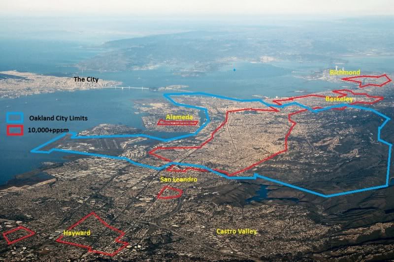
That large red area of 10,000+ppsm in Hayward is 27 miles from the City.
__________________

"Two roads diverged in a wood, and I—I took the one less traveled by, And that has made all the difference."-Robert Frost
Reply With Quote
     
     
  #154  
Old Posted Sep 15, 2012, 3:49 PM
memph memph is offline
Registered User
 
Join Date: Dec 2010
Posts: 1,854
I made a map of Greater Toronto 2006 census tracts with densities of over 10,000 ppsm a while back. The census tracts are about 5000 people each, so relatively comparable to neighbourhoods.
Reply With Quote
     
     
  #155  
Old Posted Sep 24, 2012, 10:03 AM
Chicago103's Avatar
Chicago103 Chicago103 is offline
Future Mayor of Chicago
 
Join Date: Mar 2003
Location: Chicago
Posts: 6,060
Chicago actually has more in common with Los Angeles (in the relatively flat sections with gridded streets) than it does with New York City in terms of density patterns.

I was on google earth looking at average residential blocks in Los Angeles and they tend to be 660 feet long by 330 feet wide, the same as Chicago. Alleys are also pretty common in Los Angeles, not anywhere near universal like Chicago but I would say about half of the normal residential streets have them. What is kind of cool is that on google earth street view you can actually go down many of the alleys in Los Angeles unlike in Chicago and they look very similar. In fact even on the residential streets themselves if you ignore the obvious differences in flora and architecture the building scale is pretty similar between the two cities. There are many bungalow neighborhoods in LA that remind me of the bungalow belt of Chicago and the number of housing units per X feet of street frontage looks pretty similar. So similarly sized blocks and amount of housing on blocks.

Also outside of neighborhoods near the Chicago lakefront (where the commercial streets look like closer to those of New York City albeit a bit scaled down as described earlier) the commercial streets look quite similar between Los Angeles and Chicago. I am talking about major streets in Chicago like Western, Pulaski, Cicero, etc. that have that quasi-auto and pedestrian oriented mesh with smaller scaled commercial and residential buildings facing the sidewalk mixed in with strip malls and car dealerships and auto shops thrown in here and there. Also Los Angeles has a huge industrial/warehouse area just southeast of it's downtown that reminds me a lot of the Near West Side and Goose Island areas Chicago with it's relative low density industrial/warehouse and increasingly residential loft mix. There are also some parallels between development along the north and south branches of the Chicago River and the Los Angeles River most importantly the lack or residential uses near them in parts.

Most importantly the numbers just support the fact that Los Angeles and Chicago are more similar to each other than New York City as far as density. Los Angeles has a population density of 8,092 people per square mile whereas Chicago has 11,864 per square mile whereas New York City has a whopping 27,243 per square mile! Chicago is just under 1.5 times as dense as LA but NYC is more than twice as dense as Chicago, in fact 2.3 times as dense.
__________________
Devout Chicagoan, political moderate and paleo-urbanist.

"Auto-centric suburban sprawl is the devil physically manifesting himself in the built environment."
Reply With Quote
     
     
  #156  
Old Posted Sep 30, 2012, 11:52 PM
Rail Claimore's Avatar
Rail Claimore Rail Claimore is offline
Registered User
 
Join Date: Jul 2001
Location: Dallas
Posts: 6,231
Quote:
Originally Posted by Chicago103 View Post
Chicago actually has more in common with Los Angeles (in the relatively flat sections with gridded streets) than it does with New York City in terms of density patterns.

I was on google earth looking at average residential blocks in Los Angeles and they tend to be 660 feet long by 330 feet wide, the same as Chicago. Alleys are also pretty common in Los Angeles, not anywhere near universal like Chicago but I would say about half of the normal residential streets have them. What is kind of cool is that on google earth street view you can actually go down many of the alleys in Los Angeles unlike in Chicago and they look very similar. In fact even on the residential streets themselves if you ignore the obvious differences in flora and architecture the building scale is pretty similar between the two cities. There are many bungalow neighborhoods in LA that remind me of the bungalow belt of Chicago and the number of housing units per X feet of street frontage looks pretty similar. So similarly sized blocks and amount of housing on blocks.

Also outside of neighborhoods near the Chicago lakefront (where the commercial streets look like closer to those of New York City albeit a bit scaled down as described earlier) the commercial streets look quite similar between Los Angeles and Chicago. I am talking about major streets in Chicago like Western, Pulaski, Cicero, etc. that have that quasi-auto and pedestrian oriented mesh with smaller scaled commercial and residential buildings facing the sidewalk mixed in with strip malls and car dealerships and auto shops thrown in here and there. Also Los Angeles has a huge industrial/warehouse area just southeast of it's downtown that reminds me a lot of the Near West Side and Goose Island areas Chicago with it's relative low density industrial/warehouse and increasingly residential loft mix. There are also some parallels between development along the north and south branches of the Chicago River and the Los Angeles River most importantly the lack or residential uses near them in parts.

Most importantly the numbers just support the fact that Los Angeles and Chicago are more similar to each other than New York City as far as density. Los Angeles has a population density of 8,092 people per square mile whereas Chicago has 11,864 per square mile whereas New York City has a whopping 27,243 per square mile! Chicago is just under 1.5 times as dense as LA but NYC is more than twice as dense as Chicago, in fact 2.3 times as dense.
Los Angeles had its biggest era of growth in the first two decades after WWII, the same time when the Northwest and Southwest sides of Chicago were built out as well as much of the housing stock in the nearby suburbs inside the Tri-State Tollway. That's why the massing of the two cities (excluding the lakefront in Chicago) is similar. The differences really start kicking in when you get to the collar counties of each metro area: Los Angeles has a minimal reduction of the intensity of its land use when you leave LA County. The same can't be said for the collar counties outside Cook.

In fact, one can observe this difference by merely looking at road infrastructure in the respective areas. A typical square mile of suburban Chicagoland is served by a grid of arterial roadways lining each side having 4 lanes each: that amounts to 16 lane miles serving one square mile of suburbs. In suburban Southern California though, a typical square mile is bordered by arterial roadway that have 6 lanes, with another 4 lane arterial every half mile between the larger arterials going both N/S and E/W: this amounts to 32 lane miles serving that same square mile in say, Orange County. That makes sense considering the suburbs of LA are roughly twice the population density as the suburbs of Chicago.
__________________
So am I supposed to sign something here?
Reply With Quote
     
     
  #157  
Old Posted Oct 1, 2012, 1:40 AM
min-chi-cbus min-chi-cbus is offline
Registered User
 
Join Date: Feb 2005
Posts: 497
Quote:
Originally Posted by Crawford View Post
I don't think this is true.

Manhattan's average household size is increasing, not decreasing.

In particular, the proportion of children is rising, as a higher proportion of families choose to raise their kids in the city. The number of Manhattan children under the age of 10 has soared in recent years.

Overall unit count is decreasing in many parts of Manhattan, though, because there have been so many apartment combinations.

Many older buildings had their huge prewar units chopped up beginning in the Great Depression, and moreso during the 50's through the 70's. Those buildings are steadily getting their grand apartments back, as folks combine adjacent units.

And buildings of a more recent vintage (say 70's through the early 90's) had a ton of smaller units, which have steadily been combined, as more families buy into these buildings. So you have formerly 200 unit unit highrises that now have 150 units or even fewer, though more residents per unit (but overall fewer residents in the building).

Extreme examples are in the wealthiest parts of Manhattan. Many of those grand prewars along Fifth Ave., Park Ave. or Central Park West have very few apartments. There are 20-floor buildings with 12 units. These are huge apartments.


Yeah, I don't know a ton about NYC but I'd bet more than anything it's largely due to the transition from middle class/lower middle class to upper class and upper middle class, whom require more space per unit, regardless of how many people reside in each unit. The number of square feet per resident likely increased in the past decade.
Reply With Quote
     
     
  #158  
Old Posted Oct 1, 2012, 6:34 AM
animatedmartian's Avatar
animatedmartian animatedmartian is offline
Registered User
 
Join Date: Nov 2010
Posts: 2,956
Detroit had a relatively small areas of high density. The red areas had up to 70-80,000 ppsm in 1950 (going by census blocks). The area in green (Hamtramck) had 20,000 ppsm. Everywhere else pretty much was a decrease in density until you reached the rural areas which was about a dozen miles out during that time.


Dramatic difference today.


The housing of this area is paticularly interesting (from the few blocks of them left).


Reply With Quote
     
     
  #159  
Old Posted Oct 1, 2012, 6:38 AM
Derek Derek is offline
Registered User
 
Join Date: Aug 2006
Location: Portland, OR
Posts: 9,545
Ouch...poor Detroit.
__________________
Portlandia
Reply With Quote
     
     
  #160  
Old Posted Oct 1, 2012, 6:45 AM
animatedmartian's Avatar
animatedmartian animatedmartian is offline
Registered User
 
Join Date: Nov 2010
Posts: 2,956
Blame freeways, the superblock developments, and bottleneck road engineering. For most neighborhoods, it isolated the core from them. In the map in my above post, this area was actually a high density ghetto. So city planners weren't too kind to the area when it came to redevelopment. I suspect had this area survived, it would have likely been genetrified due to it's proximity to the core (like many other cities). But looking at it now, it doesn't seem too appealing. Yet the urban frabric is still there for high density redevelopment. The question is just whether or not the demand for high density development is there.

Reply With Quote
     
     
This discussion thread continues

Use the page links to the lower-right to go to the next page for additional posts
 
 
Reply

Go Back   SkyscraperPage Forum > Discussion Forums > City Discussions
Forum Jump


Forum Jump


All times are GMT. The time now is 10:36 AM.

     
SkyscraperPage.com - Archive - Privacy Statement - Top

Powered by vBulletin® Version 3.8.7
Copyright ©2000 - 2024, vBulletin Solutions, Inc.