So I decided to play transportation planner for the afternoon. Some thoughts on the potential SW Corridor routes.
 Tie in to existing transit
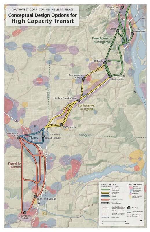
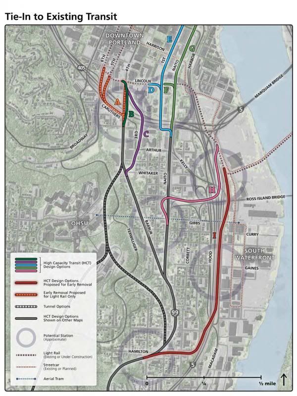
Option B looks like the best choice, as it ties in well to the transit mall, and routes to OHSU, without requiring rebuilding existing (and recently completed) work for PMLR.
Options H & I, which show the idea of serving South Waterfront are interesting, but should be discarded. Firstly, South Waterfront is going to be very well served by transit already, between the yellow and orange lines, the streetcar, the tram and bus lines. Secondly, it would increase pressure on the aerial tram, which is apparently already at capacity. Lastly, it’s insane to go a lower elevation than downtown and then spend a lot of effort getting back up to the grade of Barbur.
Options E & G are non-starters because they don’t touch the transit mall.
 South Portland to Burlingame
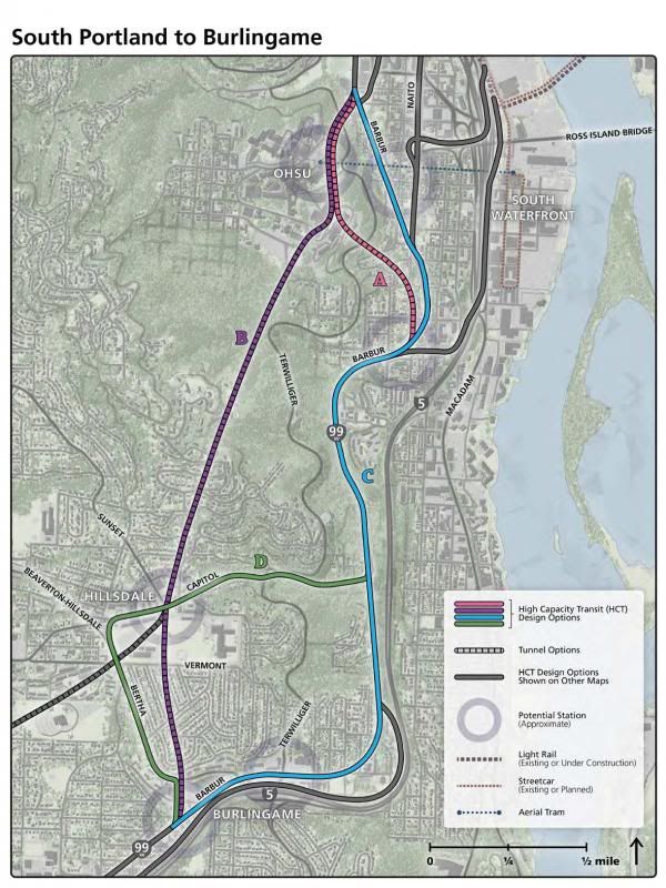
Option B, Medium Tunnel - Exit at Bertha, please. If we’re going to do this at all, let’s do it right. This is both the only effective way to serve OHSU and Hillsdale, and should also be dramatically faster than any other option. If Portland is serious about increasing TriMet’s modal share, it needs to make transit time-competitive with driving, and this is a major way to do so.
Option C, along Barbur, has few potential land-use benefits, and will require major engineering to accomplish anyway. Witness how long it’s taken them to replace the bridge on I-5 at the Terwilliger curves.
 Burlingame to Barbur Transit Center
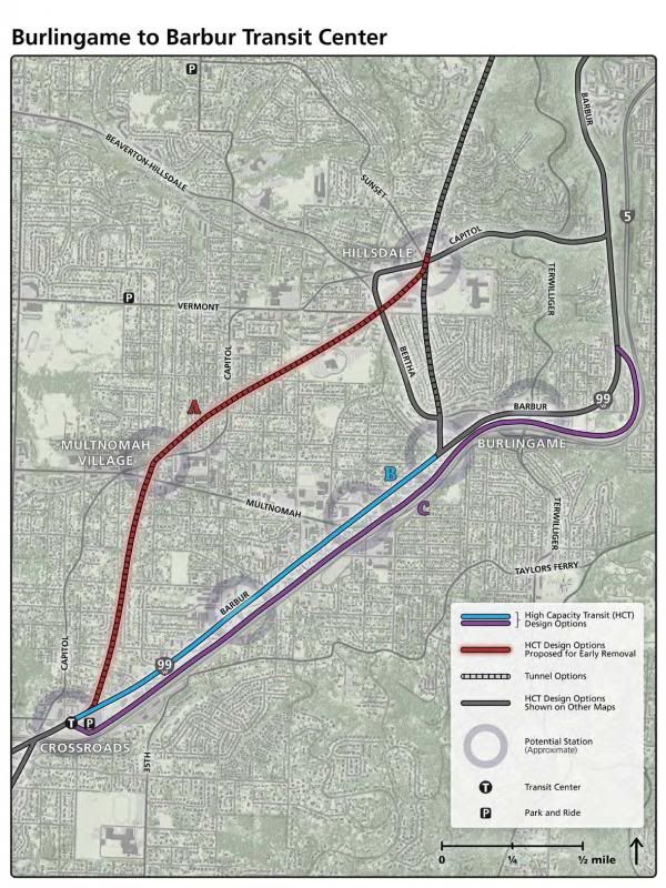
Option B, at grade along Barbur, presents some really interesting opportunities to make Barbur into a ‘main street’ for that part of SW Portland. Unlike the closer in sections of Barbur, it seems like there’s a lot of underutilized commercial land on either side of the street that could support dense, mixed use development. The rebuilding of the street would be a great opportunity to improve walking and biking conditions too. I just hope they make a more pleasant streetscape here than they did along N Interstate.
Option A, a continuation of the OHSU tunnel, seems like it’s too expensive to justify for the potential benefits (serving Multnomah Village). Option C has no advantages whatsoever.
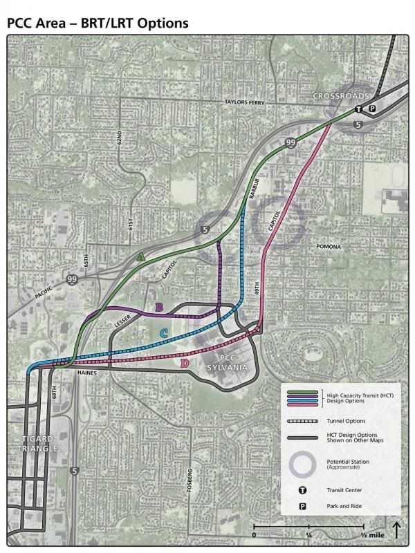
 PCC Area
I don’t have a strong preference between option B, C or D. I guess whichever serves PCC most cost effectively.
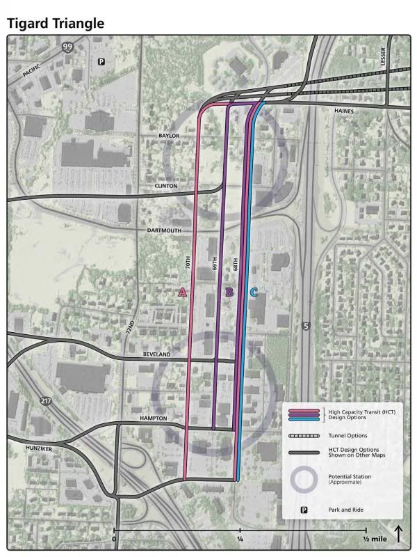
 Tigard Triangle
See below.
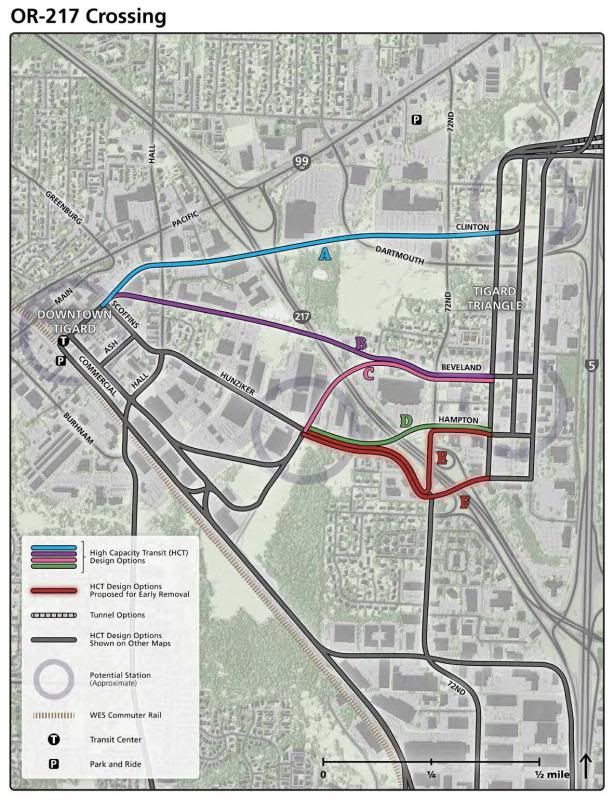
 OR-217 Crossing
Option A. As the Metro document states, this “provides most efficient transition between alignment north of Tigard and alignment south of Tigard”. I realize this serves Tigard Triangle less well, but serving the southern end of the Tigard Triangle before making a big loop to the North/West, as options B, C and D do, creates a permanent time penalty for anyone using the line.
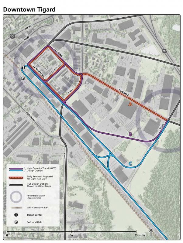
 Downtown Tigard
Option C, I think? All the options seem to serve Tigard Transit Center well, which is important for connections to WES and bus lines.
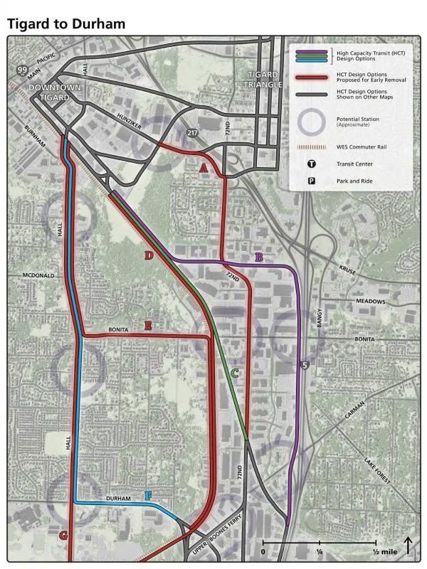
 Tigard to Durham
Option C, along the WES line, as it provides the most direct route from Tigard TC toward Bridgeport Village. It doesn’t serve the Tigard library or municipal offices, but I don’t think those will provide such a large demand that they’re worth choosing Option F for. I’m not familiar with Hall Blvd at all, but it doesn’t seem like an appropriate street to build a MAX line along.
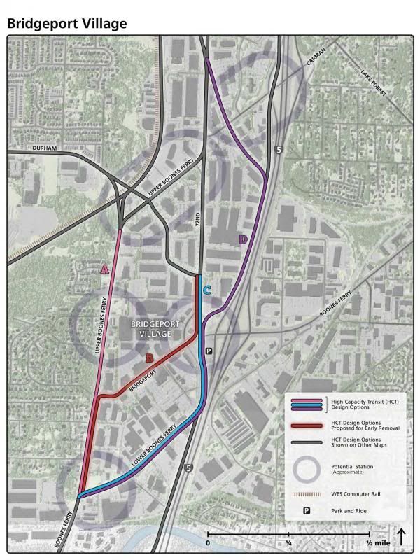
 Bridgeport Village
Options C or D 72nd / Lower Boones Ferry or along I-5, as it provides the best access to Bridgeport Village.
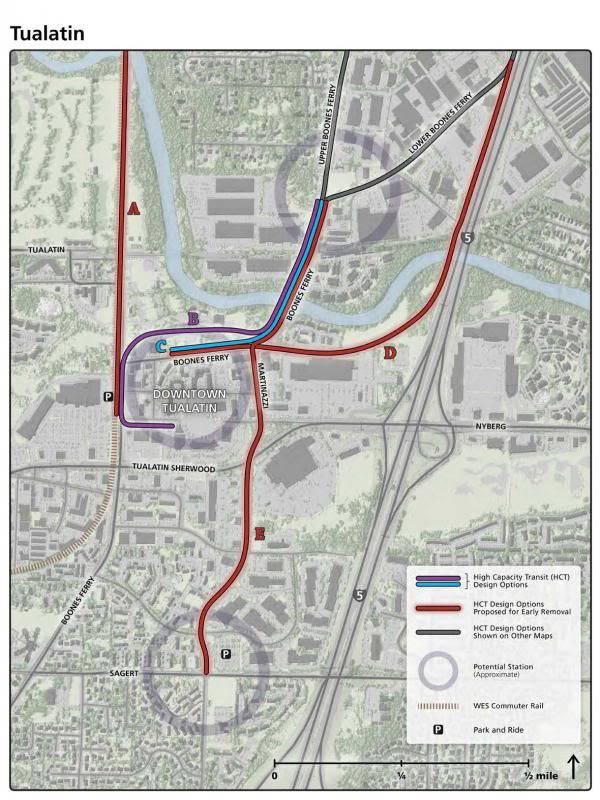
 Tualatin
Option B, WES Connection via Boones Ferry. If you’re going to almost all the way to the WES station, as in Option C, you might as well go all the way.


 Prev
Prev


 Linear Mode
