But nobody is forcing you to ride a bike, this discussion is about loosening the monopoly that auto travel has on all transportation spending decisions. Cars may always be the predominant mode but if we are going to subsidize infrastructure it should reflect the public good by taking other users into consideration and neighborhood-level circumstances.
Vast parts of Houston consist of a grid of low-traffic neighborhood streets lined with small houses on narrow lots, multistory townhomes, dingbat office buildings, etc and are actually pretty dense. The frequency of buses on major thoroughfares tends to be pretty good too, you could almost rely on the bus in the right areas. The only thing lacking is the street itself. There are too many areas with extremely narrow blacktop laneways with culverts and utility poles next to them.
IMO the next step now that transit has been greatly upgraded(relative) in the last 15 years or so is to go in and improve "the last mile" with sidewalks, off street bike paths(those green painted ones), just improved streets in general. While streets are being torn up would be a great time to expand storm sewers and lay down fiber internet too.
At the rate infill is being built, the area inside the loop could be a totally different kind of city in 20 years. Comparing it to the past, it already is. It would be a missed opportunity to not take advantage of this.
From SSP I've learned of Los Angeles' transformation. A couple decades ago it was like Houston, a rapidly growing sprawling city with a suburban mindset and a long list of urban problems. But then it embraced building upwards and transit and it has greatly improved once blighted neighborhoods. DTLA used to be a lot like downtown Houston - a field of asphalt parking lots full of roaming homeless with some supertall PoMo office towers hermetically sealed from the world below.
Quote:
Originally Posted by Sun Belt

Also affordability issues.
A restaurant cook is not going to live in the same building as a techbro in North Beach.
People have to commute from affordable areas to areas with zero housing supply.
|
But a restaurant cook might live in the East Bay and ride BART. North Beach has no direct rapid transit yet.
I don't think affordability in the central part of San Francisco is a realistic goal in the long term, because like lower and midtown Manhattan or central London or Paris it is a elite hub of global commerce. The real challenge is that the Bay Area doesn't have affordable areas tens of miles from the cores, but that is a more complex, different sort of issue and transit helps, not hurts when it comes to that.
Quote:
|
I've seen this pic countless times. It's a simplistic take on a complex issue. That's assuming all those people live near one another, in town, going in the same direction and live/ work near a bus stop or subway station. What if someone has a cross town appointment and are on a time constraint? Unless point A and point B are along the same bus/ subway line, a car will be faster.
|
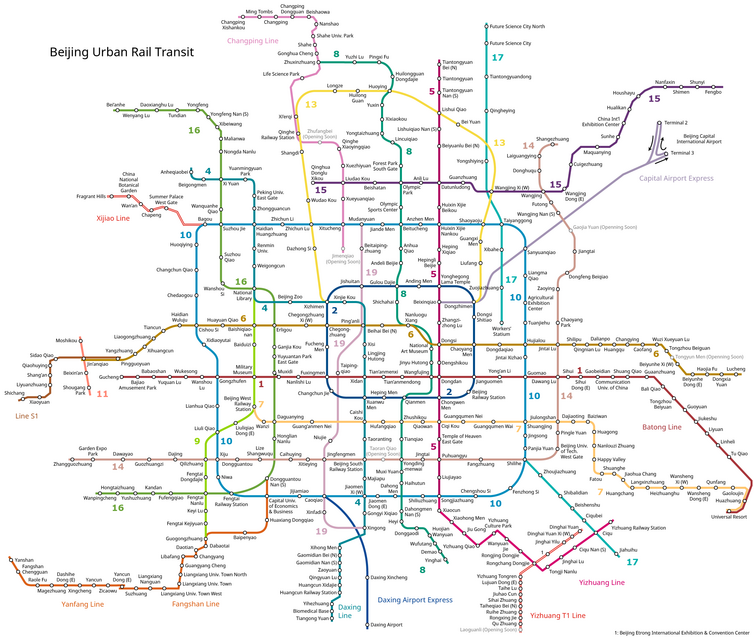
Actually it is simple. Not all cities are as low density as American ones, being more or less centralized may not matter than much. If you look at metro maps of cities around the world, many have a grid topology with suburb-suburb loop lines instead of a hub-and-spoke radiating from downtown.
Presumably someone who has a special appointment takes a taxi or gets a ride and it's not like families don't have cars.


 Prev
Prev


 Linear Mode
