A huge tip of the hat to jlousa for the document
The following are exerts from Translink's Waterfront Station Transportation Hub Conceptual Plan Request For Proposal.
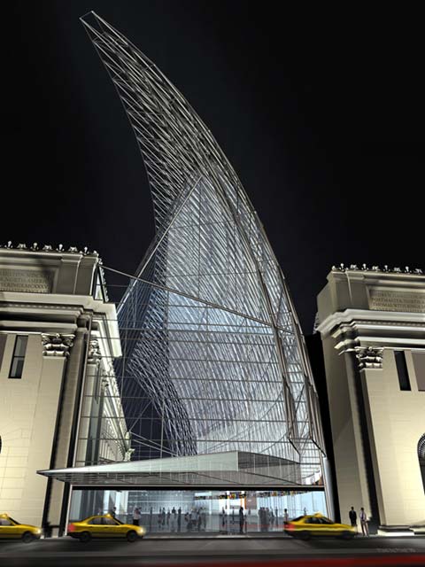
The South British Columbia Coast Transportation Authority ("the SBCTA" or "TransLink") is seeking consultant services to develop a Waterfront Hub Transportation Concept Plan ("Transportation Concept Plan") for Waterfront Station, located on West Cordova Street at the gateway between the Core Business District (CBD) and Gastown. The Concept Plan will be used as a key input into the City of Vancouver's ("CoV") Central Waterfront Transportation Hub (the "Hub") Study. The intent of the Plan is to guide the development of a world class transportation facility that is highly functional, accessible to a variety modes and users and a destination in and of itself. It must keep pace with increasing transit ridership and reflect the importance of the station as a multimodal transit hub.
It is planned that the Hub be a showcase for the city and that it meet the highest international standard for transportation hubs for the next 50-100 years.

Waterfront Station Transportation Hub Conceptual Plan - Page 56
As part of the CoV Hub Study, the City will be engaging an engineering consultant to carry out feasibility analysis and develop preliminary structural concepts and construction cost estimates for a number of elements of their Concept Plan, including: a viaduct road network north of Cordova Street and east of Howe Street; a new transit concourse north of the Waterfront Station building; two new development sites above the railway tracks south of the new Canada Place viaduct extension; and a new entrance to the Granville Square parkade from Cordova Street. The results of this work are expected in late April, 2008. TransLinkYs consultants will be required to review the results of this engineering work, and where necessary, incorporate findings into the Transportation Concept Plan.
The centrepiece of the Waterfront Hub area is Waterfront Station, a landmark heritage building originally built as the CPR railway station. Waterfront Station features limited retail and office space and is served by a number of key regional transportation lines (Expo Line SkyTrain, West Coast Express commuter rail, SeaBus passenger ferry, local and express bus service, future Canada Line and a potential streetcar). Overall, the space at Waterfront Station hub does not live up to its potential as a dynamic multimodal interchange. Integration between transportation modes and the physical and visual connections to the surrounding neighbourhood must be improved
Waterfront Station is the terminus and seventh busiest station of the SkyTrain networkand forms an integral part of the regional transit system servicing Metro Vancouver.
Current and potential future transportation services at Waterfront Station include:
SeaBus to Lonsdale Quay:
-3.2 km passenger ferry linking North Vancouver with downtown Vancouver.
-Two vessels, each carrying up to 400 passengers serve an average of 17,700 weekday passengers.
-Annual ridership in 2007 was 5.4 million boardings, a 4% increase over the previous year and projections suggest an additional 4% in 2008.
-A third SeaBus is to enter service in 2009, to address forecasted increased demand for SeaBus service by allowing service every 10 minutes in peaks, up fiom every 15 minutes today.
-North Shore bus service feeding the Seabus is also expected to improve significantly with frequencies increasing from 15 to 10 minutes when the third SeaBus enters service.
Expo & Millennium Line SkyTrain Terminus
-Both SkyTrain routes (Expo and Millennium) terminate at Waterfront Station.
-Trains every 108 seconds in peak periods.
-Weekday SkyTrain boardings at Waterfront are estimated at 15,600, with 10,400 boardings Saturdays and 7,000 Sundays.
-The AM peak hour sees 1,350 boardings and 2,000 alightings at this station.
-The PM peak hour sees 2,700 boardings and 1,825 alightings at this station.
-There is significant "reverse peak" travel at this station, generated by transfers to and from SeaBus and West Coast Express.
West Coast Express (WCE) Terminus
-Commuter rail service linking Mission, Port Haney, Maple Ridge, Pitt Meadows, Port Coquitlam, Coquitlam and Port Moody with downtown Vancouver.
-Five trains operate only in the peak direction, weekdays only.
-Trains operate approximately every 30 minutes with passenger volumes of up to 1,300 per train arriving and departing Waterfront.
-Annual ridership in 2007 was 2.4 million boardings, a 4% increase over the previous year.
-Since opening in 1995, ridership has increased steadily from about 5,000 riders a day to well over 9,000, with an overall growth rate of 60 per cent.
Bus Terminus:
-It is intended that the Hub become more of a regional rapid transit centre serving multiple modes of rail, SeaBus, and regional higher order bus services as well as local services. Part of the study will be to determine the overall desire for services, the number of bus routes and type of route including potentially Bus Rapid Transit service along Hastings to Simon Fraser University as well as limited stop B-Line services and local trolley service.
Heliiet Port
-Helijet scheduled helicopter service operates to Victoria from a floating dock adjacent to the SeaBus terminal.
In addition to existing transportation services, the following services are planned or are potential future additions to the hub, which will need consideration as part of this study.
Canada Line Terminus
-The Canada Line rail rapid transit system to Richmond and the airport will open in late 2009, replacing the #98 B-Line that now starts on Cordova Street in front of Waterfront Station. The Canada Line will terminate below Granville Street, just south of Cordova Street, with one of the station entrances leading to the main hall of the CPR station to provide connections to other transit services at Waterfront Station. A second entrance at Granville and Hastings will serve much walk-in traffic tolfrom the CBD that now uses the #98 B-Line stop at Burrard Station, as well as some bus connections
Future: Downtown Streetcar
-The City of Vancouver has proposed a streetcar network for downtown Vancouver with a phase 1 line extending from Waterfront Station around False Creek to Granville Island. More information can be found at:
http://www.city.vancouver.bc.calengs...treetcar/index.
Future: Passenger Ferry Services
-Private inter-regional passenger ferry services to Victoria and Nanaimo have operated in the past from the outside berth of the SeaBus terminal and should be provided for in the future. TransLink may also expand passenger ferry services within the region to Bowen Island, West Vancouver and potentially other destinations.
Future: Intercity Passenger Rail Services
-While not currently on the horizon, consideration shall be given to providing passenger and track capacity for future intercity passenger rail services (e.g., to Seattle and Portland) within the facility given its strategically central location and lack of alternatives.
Future: Transit Expansion
-The Province of British Columbia recently announced a plan to invest $11 billion in the regional transit network. This plan includes a major expansion of the rapid transit, rail and bus system, as well as significant upgrades to existing facilities. This investment will significantly increase transit ridership and thereby add considerable volume to existing transit facilities, including Waterfront Station.
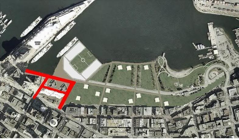
Potential Future: Whitecaps Stadium
-The study should take into account the possible development of a 15-30,000 seat stadium within the Central Waterfront Port Lands, currently under discussion between the Whitecaps and the Vancouver Port Authority.
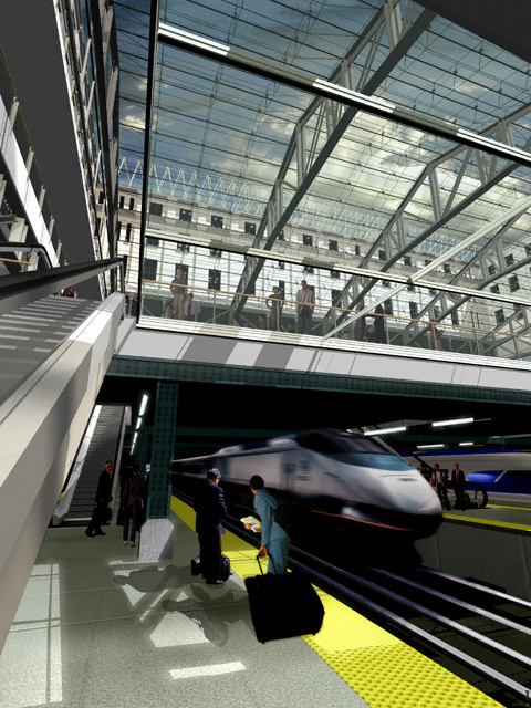
Options should acknowledge the diverse mix of users (commuters, workers, tourists, cyclists, residents, etc.) of the station hub and surrounding area and propose ways to enhance its function, vitality, and public image and visibility both as a transportation hub and a destination. Specifically, options should: Identify passenger and facility improvements that will enhance access, connectivity between modes, comfort, safety and wayfinding throughout station area;
-Address multi-modal transportation integration and expansion (e.g., bus, train, SkyTrain, SeaBus, streetcar, passenger ferry, cycling, walking, etc.);
-Identify preferred locations for transit services within the facility (.e.g., specific locations on street or within a designated terminal area).
-Identify special zones (e.g., transit priority, ticket purchasing areas, fare paid zones, potential fare gatelticket barrier cordons), indicating required capacity and widths, passenger amenities, wayfinding and information improvements within the station and the immediate Hub area.
-Optimize all at-grade, above grade, vertical and horizontal connections to and within the station hub, including Canada Line and bus transfer zones, and to the surrounding pedestrian and cycling network.
-Maximize the legibility of vertical and horizontal wayfinding and orientation opportunities for pedestrians and cyclists to all modes.
-Identify vertical connections between the modes, key destinations and street grade, and any other facilities (e.g., ramps) required to service bicycles and people with limited mobility.
-Incorporate principles of safety and security in ways that enhances the Station as a public space, both day and night and throughout the year.
-Propose scenarios for expanding people conveyance systems such as locations of elevators, stairs, escalators, walkway widths, etc.
-Improve cycling access and wayfinding from the surrounding proposed street system.
-Explore options for providing cycling storage at the station.
-Assess and identify any retail opportunities within the station, including cycling facilities.
-Identify ways to appropriately integrate the station with the neighbourhood and to create a better connection with the waterfront.
-Propose innovative ways of expanding the existing building / space while respecting the heritage and character of the CPR station building.


 Prev
Prev


 Linear Mode
