HomeDiagramsDatabaseMapsForum About
     

Go Back   SkyscraperPage Forum > Regional Sections > Canada > Alberta & British Columbia > Vancouver > Transportation & Infrastructure


Closed Thread

 
Thread Tools Display Modes
     
     
  #241  
Old Posted Apr 27, 2016, 9:00 PM
Pinion Pinion is offline
See ya down under, mates
 
Join Date: Jul 2007
Posts: 5,167
Quote:
Originally Posted by officedweller View Post
The problem with having 2 express lanes and 1 collector lane on the bridge approach is that it makes the 2 on-ramps from Main Street dangerous, because the traffic in the single collector lane cannot move left (as a courtesy) in times of light traffic.

What they could do is widen the HWY 1 overpass over Main St. and have the 2 on-ramps merge before taking their own lane on the bridge:


https://www.google.ca/maps/@49.31279.../data=!3m1!1e3

They could probably do the same thing within the existing width of the overpass (5 lanes) if:
- they shifted the "exit only" point from the Main St. westbound exit to the Main/Dollarton eastbound exit (Main St. westbound would just be an exit off the 2 lane hwy)
- then Hwy 1 northbound would just use 2 lanes of the overpass, and the southbound could use 3 lanes of the overpass (2 Hwy 1 and 1 on-ramp).
Yeah that was my thinking in needing to widen right up to the bridge. The Dollarton onramp is a disaster no matter what otherwise.

Looks like they'll make it longer like the Boundary westbound onramp but that just made it go from terrifying to shitty.
     
     
  #242  
Old Posted Apr 27, 2016, 9:19 PM
urbancanadian urbancanadian is offline
Registered User
 
Join Date: Aug 2014
Location: Vancouver
Posts: 671
I was thinking the same thing. Would it be worth it to close the last ramp - from EB Main Street onto the IMB SB? I know it would be more circuitous, but drivers could still enter the highway from the new/improved entrance off of Seymour Boulevard. It would make for one less merge before the bridge...
     
     
  #243  
Old Posted Apr 27, 2016, 9:24 PM
officedweller officedweller is offline
Registered User
 
Join Date: Jul 2001
Location: Vancouver
Posts: 38,361
Bumping this to the next page:

Quote:
Originally Posted by officedweller View Post
They could probably do the same thing within the existing width of the overpass (5 lanes) if:
- they shifted the "exit only" point from the Main St. westbound exit to the Main/Dollarton eastbound exit (
Main St. westbound would just be an exit off the 2 lane hwy)
- then Hwy 1 northbound would just use 2 lanes of the overpass, and the southbound could use 3 lanes of the overpass (2 Hwy 1 and 1 on-ramp).


https://www.google.ca/maps/@49.31279.../data=!3m1!1e3
     
     
  #244  
Old Posted Apr 27, 2016, 10:34 PM
jollyburger jollyburger is offline
Registered User
 
Join Date: Dec 2015
Posts: 9,588
Refresher on what they had on mind with the new Dollarton onramp


Ministry of Transportation
     
     
  #245  
Old Posted May 2, 2016, 6:21 AM
cornholio cornholio is offline
Registered User
 
Join Date: Jun 2006
Posts: 3,911
I assume the new Lynn river bridge will have the first 4 lanes built on the outside edge of the current bridge. Traffic diverted to them and the current bridge dismantled. And then the remaining 4 lanes completed in the middle. I don't see how else they could do it given the limited space to work with and needed to keep that highway flowing.
     
     
  #246  
Old Posted May 13, 2016, 4:33 AM
SOSS SOSS is offline
Registered User
 
Join Date: Jan 2014
Posts: 661
Keith Road Bridge closed this weekend

Associated with Hwy 1 access. I suspect they'll be moving the entire structure to the roadway just west of its current location for final dismantling. The old bridge has had most of the concrete roadway removed and is lifted and sitting on blocks.

Quote:
We are removing the old Keith Road Bridge during the weekend of May 14 and 15. This will require that we completely close Keith Road between Lynnmouth Ave and Mountain Highway.

Traffic barriers at either end of the closure will be put in place in the early morning hours of Saturday, May 14, and we expect to have the road reopened by rush hour on Monday morning.

Planning an alternate route
Please review the detour map to plan an alternate route — the closed section of the road is shown in red; the detour route is shown in green — and allow extra travel time.

Thank you for your patience as we complete this important piece of the Keith Road Bridge replacement project.
     
     
  #247  
Old Posted May 13, 2016, 4:43 AM
jollyburger jollyburger is offline
Registered User
 
Join Date: Dec 2015
Posts: 9,588
Quote:
Originally Posted by SOSS View Post
Associated with Hwy 1 access. I suspect they'll be moving the entire structure to the roadway just west of its current location for final dismantling. The old bridge has had most of the concrete roadway removed and is lifted and sitting on blocks.


NV District's Twitter
     
     
  #248  
Old Posted May 15, 2016, 1:44 AM
jollyburger jollyburger is offline
Registered User
 
Join Date: Dec 2015
Posts: 9,588
Few more from the District. They're driving it down the road to dismantle it.


  #249  
Old Posted May 15, 2016, 2:38 AM
Klazu's Avatar
Klazu Klazu is offline
Registered User
 
Join Date: Apr 2012
Location: Above Metro Vancouver clouds
Posts: 10,187
Wow, that's a cool transport!
     
     
  #250  
Old Posted May 15, 2016, 4:18 AM
jollyburger jollyburger is offline
Registered User
 
Join Date: Dec 2015
Posts: 9,588
They finished ahead of schedule, the road opened up at 8PM.
     
     
  #251  
Old Posted May 17, 2016, 6:20 AM
SOSS SOSS is offline
Registered User
 
Join Date: Jan 2014
Posts: 661
Quote:
Originally Posted by jollyburger View Post
Refresher on what they had on mind with the new Dollarton onramp


Ministry of Transportation
I wasn't too sure why they were replacing the Dollarton Hwy to Hwy 1 southbound on-ramp until I took a closer look this week. The fly over currently only allows for 4 lanes of through traffic. The new one will allow for more. That leaves the question will it be 6 or 8 lanes?
     
     
  #252  
Old Posted May 17, 2016, 6:36 AM
jollyburger jollyburger is offline
Registered User
 
Join Date: Dec 2015
Posts: 9,588
Quote:
Originally Posted by SOSS View Post
I wasn't too sure why they were replacing the Dollarton Hwy to Hwy 1 southbound on-ramp until I took a closer look this week. The fly over currently only allows for 4 lanes of through traffic. The new one will allow for more. That leaves the question will it be 6 or 8 lanes?
I think at best you'll see a third westbound lane to allow for more room for people to exit. There might be more room but I don't see them adding more lanes especially eastbound since they'll just eventually have to merge back in at the bridge.

I think the biggest problem is that the merge is so short that people end up stopping and traffic backing up.
     
     
  #253  
Old Posted May 18, 2016, 6:06 AM
SOSS SOSS is offline
Registered User
 
Join Date: Jan 2014
Posts: 661
Quote:
Originally Posted by jollyburger View Post
I think at best you'll see a third westbound lane to allow for more room for people to exit. There might be more room but I don't see them adding more lanes especially eastbound since they'll just eventually have to merge back in at the bridge.

I think the biggest problem is that the merge is so short that people end up stopping and traffic backing up.
I think volume is the largest problem. Traffic is often bottle-necked around the McGill area. So much traffic cramming into 2 lanes in each direction.

I really can't see the government building a new flyover with the same limitations for through traffic beneath. That would be very short sighted even for the current iteration of the Liberals.
     
     
  #254  
Old Posted Jun 10, 2016, 4:06 AM
SOSS SOSS is offline
Registered User
 
Join Date: Jan 2014
Posts: 661
Thoughts on Hwy 1 over Lynn Creek

While stuck in traffic going through the NS bottleneck I had the following thoughts on a future bridge over Lynn Creek. The District of North Vancouver is interested in a new connection over Lynn Creek north of Hwy 1 basically connecting St Denis Ave/Keith Road to Mountain Hwy. I think to build a new Highway 1 bridge over Lynn Creek a temporary bridge will need to be constructed to allow for partial tare down and reconstruction of a new bridge.

My thoughts are that the temporary bridge is upgraded to a permanent bridge accommodating what the district is after including alignment (difference paid for fully by the district). After construction of this two lane bridge, westbound highway 1 traffic is diverted onto the new bridge, eastbound traffic is diverted to where westbound traffic was. Tare down of eastbound half of existing bridge and rebuild of new eastbound 1/2 bridge (likely 3 possible 4 lanes). Shift traffic over and deconstruct remaining old orange bridge and replace with new westbound 1/2 bridge (likely 3 possible 4 lanes).

This tactic would allow for no decrease in number of lanes (but I assume a reduction in traffic speed to an appropriate construction speed) and the district would get their new connection over Lynn Creek northeast of the highway. No matter what, logically they can't reduce lane numbers to build a new bridge, can they?
     
     
  #255  
Old Posted Jun 10, 2016, 5:30 PM
Pinion Pinion is offline
See ya down under, mates
 
Join Date: Jul 2007
Posts: 5,167
MLA Jane Thornwaite posted this on twitter saying an update is coming soon. Not sure what to make of the drawings - looks like the bottom/left one is the updated version with a new Lynn Creek bridge and collector lanes?! Thoughts?! Can anyone make out the text?


  #256  
Old Posted Jun 11, 2016, 3:42 AM
SOSS SOSS is offline
Registered User
 
Join Date: Jan 2014
Posts: 661
Interesting. I can't make out the words but from what I can tell they both show new connection from the main street off-ramp to connect to Seymour Blvd extension and new on-ramp connection from the same extension onto Hwy 1 eastbound. The map on the right clearly shows a new bridge connecting Keith Rd/ St Denis Ave to Mountain Highway via home acquisition and Arbourlynn Drive. The map on the left look likes leaving the existing Lynn Creek Hwy 1 bridge and adding additional bridges to either side to add movement. Interesting. I look forward to the official announcement.
     
     
  #257  
Old Posted Jun 11, 2016, 7:03 AM
jollyburger jollyburger is offline
Registered User
 
Join Date: Dec 2015
Posts: 9,588
I guess the left one is the earlier diagram with the divided off local lanes while the other option looks like it leaves the highway configuration as is and adds a new bridge/road to route around local traffic that connects up to Mountain Highway like SOSS mentioned. Which seems like a new concept drawing not posted before.

And it sounds like construction will start this fall.

Last edited by jollyburger; Jun 11, 2016 at 7:17 AM.
     
     
  #258  
Old Posted Jun 11, 2016, 7:33 AM
Pinion Pinion is offline
See ya down under, mates
 
Join Date: Jul 2007
Posts: 5,167
I think you're both wrong. DNV wanted that additional parallel bridge to the north before talk of an eight lane/collector lane bridge. Left is the new plan - a brand new wide bridge with federal funding, right was old with DNV trying to do it on their own.

Collector lanes also negate the need for that big overpass from Mt Seymour Parkway to Keith. Instead you just go in the collector lane, turn left on Mountain Hwy and right on Keith at Brooksbank.
     
     
  #259  
Old Posted Jun 12, 2016, 2:55 AM
waves's Avatar
waves waves is offline
waves
 
Join Date: Jun 2015
Location: North Vancouver
Posts: 366
I designed my own idea for this project. Will likely never happen in a million years but one can dream eh? I thought I'd post it here rather than the transit fantasy page since the fantasy is literally for this project. Check it out on the google map I created:

https://drive.google.com/open?id=1hR...Zw&usp=sharing

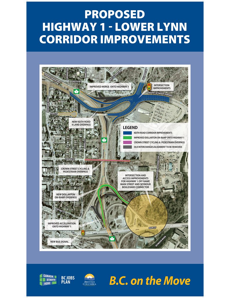
A complete redesign (and rename) of the Lower Lynn/Lynnmour area. This design has significant benefits: Increases the minimum lane width per direction to 3 lanes, reduces the number of entrances and exits such that safer and faster speed merges can occur, connects east to west phenomenally for all mode users, separates local north south traffic on to Lilloet Road rather than the highway, reduces the footprint of highway interchanges, would allow a 20 acre park to be opened, allow a complete town center to be designed above it with the now available space, would completely reinvigorate the area and make it a highly desirable place to live.

The highway continues straight off the iron workers memorial with 8 lanes and descends at highest grade reasonable until it enters the tunnel with 6 lanes each just before passing under Main Street. 2 lanes are dedicated to the Southbound Entrance /Northbound Exit for Main Street . The Main Street intersection may have to be raised in order for this to work. The tunnel continues straight and make a single turn before exiting the tunnel and crossing Lynn Creek. This would enable a wider radius curve and allow a higher max speed than 70km/h. This removes two tight curves just over Main St. and the tight curve beneath Fell Avenue. It is at the Main Street tunnel portal where the Tunnel is the thinnest at 6 lanes.

The exits/entrances at Main Street transition into Lilloet Road which is on top of the tunnel and extends into the current Lilloet Road. In order for this to work the Golf Center and the Electrical substation need to be relocated. This could be a partial relocation or a complete.

Crown street is extended on its west side to cross Lynn Creek and terminate at a Brooksbank ave interchange inclusive of an entrance to Park & Tilford. In addition, Crown Street is connected to Mt. Seymour Parkway with a new bridge.

Mt Seymour Parkway connects directly to Kieth Road. As it passes Lilloet Rd it transitions into two one way streets. In between these streets are a Northbound Entrance and a Southbound Exit. This is the first entrance northbound onto the Highway in North Van. It is also the last exit in North Van before going over the bridge.

In the tunnel itself, to allow for both the Mt. Seymour Parkway Entrance North and the Mountain Hwy Exit North, the Mountain Hwy exit splits off early and runs on the North side of the Mt. Seymour Parkway Entrance. These lanes would be separated (No switching lanes). The tunnel at this point reaches it's widest point with 1 merge lane and 3 travel lanes south bound and northbound 1 merge lane, 3 travel lanes and 1 exit lane for a total width of 9 lanes.

Mountain Highway has a full interchange and allows for all traffic to travel in all directions.
     
     
  #260  
Old Posted Jun 13, 2016, 5:47 AM
SOSS SOSS is offline
Registered User
 
Join Date: Jan 2014
Posts: 661
Update for Mountain Hwy/Hwy 1 Interchange: temporary fencing is staged and likely to go up this next week.
     
     
This discussion thread continues

Use the page links to the lower-right to go to the next page for additional posts
 
 
Closed Thread

Go Back   SkyscraperPage Forum > Regional Sections > Canada > Alberta & British Columbia > Vancouver > Transportation & Infrastructure
Forum Jump


Forum Jump


All times are GMT. The time now is 4:37 PM.

     
SkyscraperPage.com - Archive - Privacy Statement - Top

Powered by vBulletin® Version 3.8.7
Copyright ©2000 - 2024, vBulletin Solutions, Inc.