HomeDiagramsDatabaseMapsForum About
     

Go Back   SkyscraperPage Forum > Regional Sections > Canada > Alberta & British Columbia > Vancouver > Transportation & Infrastructure


Reply

 
Thread Tools Display Modes
     
     
  #201  
Old Posted Jan 30, 2009, 3:28 AM
metroXpress's Avatar
metroXpress metroXpress is offline
(||||||-||||-||||||)
 
Join Date: Jan 2009
Location: Vancouver B.C.
Posts: 2,220
Quote:
Originally Posted by tintinium View Post
Initially I thought the same thing... that they should build the station into the terminal like they do in other cities, instead of across the street. However, after thinking about it for a while I started to realize that we have the best possible configuration.

Most stations that are integrated into terminals are either below ground in the terminal or integrated through walk-ways. If you think about it, where would they run the line? As it runs parallel to the international terminal, it would have to run underground or on top of the terminal (as in on top of the building).

Underground is a no go, because of being in a flood zone and soft soil.

Above the airport is an interesting idea, with a station on the roof, but it would cause major havoc during construction and would probably have security implications.

Even if it could be built under the terminal, you would still have two flights to travel to get to departures and one flight down for arrivals.

Being underground it would also suffer from decreased visibility. It would be harder to find and less visible to travellers who step outside. As it is now, they walk out the terminal and bam, there it is right in front of them.

Right now, the only thing more convenient than the train is taxi... by about 20m.

At least we haven't got what Seattle got with their LRT. It will stop on the other side of its parking structure.

Apparently this is because it is to be extended and can't make the sharp turn at the airport, along with some other reasons, but I don't see why it couldn't have been built on top of the parking structure, after giving up a dozen parking spots or so.

Thanks for explaning that part and when I think about it...I think that
they made their best choice for the station. We will have to stick with
that for...the rest of our lives?
__________________
"Think simple…reduce the whole
of its parts into the simplest terms,
Getting back to first principles"


~ FRANK LLOYD WRIGHT
Reply With Quote
     
     
  #202  
Old Posted Jan 30, 2009, 8:13 PM
officedweller officedweller is online now
Registered User
 
Join Date: Jul 2001
Location: Vancouver
Posts: 38,350
Quote:
Originally Posted by worldwide View Post
i think the building youre talking about is on the north east corner of main and 10th. its a condo, some units may be rented, but its a strata building. it has a waves or something at grade
Thanks. That would be a barrier to acquiring the site.

****

WRT the SeaTac Station - apparently it will also serve as station for transit oriented development across the street from the airport. But I agree, it's in a lousy location for people lugging luggage (hopefully there will be lots of carts at the station).
Aside: I didn't realize that there's a road under the south end of the SeaTac runway.
Reply With Quote
     
     
  #203  
Old Posted Jan 31, 2009, 12:38 AM
twoNeurons twoNeurons is offline
loafing in lotusland
 
Join Date: Aug 2002
Location: Lotusland
Posts: 6,026
Quote:
Originally Posted by Allen View Post
Thanks for explaning that part and when I think about it...I think that
they made their best choice for the station. We will have to stick with that for...the rest of our lives?
It's practically door to door service as it is now. Remember, in most airports, the rail is further away from the ticketing area as it's under the airport or connected via underground tunnels.


Most people would agree that the Japanese know how to make trains convenient.

In Kansai International (Osaka), the trains don't go into the terminal. They have their own terminal. And it was originally built with the train in mind.

In Itami, in Osaka you can see the monorail line here:


In that context, this is pretty good (original model):
Reply With Quote
     
     
  #204  
Old Posted Feb 1, 2009, 3:58 AM
nname nname is offline
Registered User
 
Join Date: Aug 2005
Posts: 4,657
Am I the only person who posts bus routes here?

Anyways, after living in Port Coquitlam for more than 10 years, I still think the bus service here is very bad. It definitely improved since the community shuttle was introduced (the bus near my home, for example, was running bi-hourly before), but there are definitely more rooms to improve.

My observations:
  • Beside the morning and afternoon connection to WCE, the community shuttle (CS) routes just don't go anywhere
  • There is only 1 route connect to skytrain and 1 to downtown in southern Poco, while there are none in northern Poco (compare to the close-by Coquitlam station: 5 routes to skytrain and 2 routes to downtown)
  • Most of the routes in Poco doesn't even go to Coquitlam station (where most of the connections are and most people want to go)
  • Most routes are packed beyond capacity at peak (go to WCE), and running empty off peak
  • People rather walk longer distance to catch a bus to Coquitlam station than catching CS to Poco centre and transfer to Coquitlam station: 701 can gain a half to full seat load of passengers every 15 minutes from the 5 stops serving Poco, while the C37 running every 30 minutes are mostly running empty
  • 50% to 80% of the people arriving to Poco by 160 was transferring to a CS (and they had to transfer to the 160 at Coquitlam station), more than half of the passenger on the C37 in evening was coming from 160
  • The only route to skytrain, the 159, doesn't even connect well to any of the CS routes! People sometimes have to wait up to 25min for the bus, plus a 40min ride to skytrain - a total time of 1.5 hours to get to skytrain! (if the CS connect well to 169 at Coquitlam station, the whole trip can be done within 30min)
  • I know quite a few people taking C38 from Coq stn to River Springs, but it goes in a small loop around Coq town centre, another small loop around Poco town ctr, then a huge loop around the north side of Poco - a trip time of 45min just to go 3km!!
  • All CS in poco are extremely loopy: bi-direction pan-shaped loops should use 2 different route numbers
  • If you think a bus go on the same road twice is bad enough, the C38 goes on the same road THREE times per direction. And since it uses the same route number both directions, it uses the same road SIX times round trip
  • Shaughnessy and Reeve street got a lot of mid-rise apartments there, but the only bus service they got is a one-way CS route that is most likely running full during peak hours by the time it gets there
  • The David Avenue bridge had been opened for 2 years now, and no bus takes advantage of that
  • Since skytrain is coming to Coquitlam station, there will be more demand of people going to Coq stn compare to Poco ctr.. unless skytrain extends to Poco ctr (and no, LRT won't change the situation since there's still a transfer there)
I like the idea of those CS routes in Westwood Plateau where one end goes to Coquitlam Station and one end goes to Port Moody Station.. so I'm trying to do the same thing between Coquitlam and Port Coquitlam station:


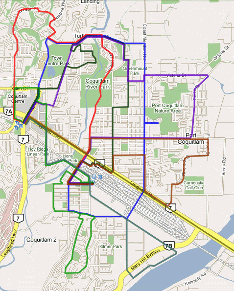
I think the map is a lot more messy than I thought after I put all the routes on there.. so I'll list them here:

#159 (not shown) [modified] Port Coquitlam Station/Braid Station
- no route change
- no need for industrial branch after evergreen line

#160 (not shown) [modified] Coquitlam Station/Vancouver
- terminate at Coquitlam station

#179 (Red) [modified] Coquitlam Station/Port Coquitlam Station via Johnson, River Springs (30min peak, 30min base, 30min weekend)
Johnson -> Robson -> Pinetree -> David -> Shaughnessy -> Wilson to Poco Stn
- more direct service to River Springs: 10-15min instead of 45min

#180 (Blue) [new route] Coquitlam Station/Port Coquitlam Station via Coast Meridian (15min peak, 30min base, 30min weekend)
Pinetree -> David -> Coast Meridian -> Kingsway -> McLean -> Pitt River -> Shaughnessy -> Wilson to Poco Stn
- better service to the apartments in Shaughnessy st.
- can terminate at Douglas College Station after evergreen line
- uses Coast Meridian overpass
- future FTN route

#189 (not shown) [cancelled]

#701 (Gold) [no change] Coquitlam Station/Maple Ridge East (15min peak, 15min base, 15min weekend)

#C30 (Dark Green) [modified] Coquitlam Station/Port Coquitlam via Lafrage Park, Oxford Heights (30min peak, 30min base, 60min weekend)
Pinetree -> Glen -> Pipeline -> Dunkirk -> Gabriola -> Harwood -> Nestor -> Gabriola -> Pipeline -> David -> Oxford -> Mason -> Wellington -> Lincoln -> Oxford -> Oxford Connector -> Lions -> Shaughnessy -> Wilson to Poco Stn
- continuous route along Oxford/Wellington
- can have more limited evening/weekend service

#C36 (Light Green) [modified] Coquitlam Station/Mary Hill via Port Coquitlam Station (15min peak, 30min base, 30min weekend)
Johnson -> Glen -> Pinetree -> Lincoln -> Westwood -> Kingsway -> Wilson -> Maple -> Wilson -> Reeve -> Pitt River -> Eastern -> Western -> Mary Hill and return
- provide both way service to Reeve
- replace Coquitlam Stn/Port Coquitlam Stn section of #160 (service to Shaughnessy at Lougheed privided by #701 and #C37)

#C37 (brown) [modified] Coquitlam Station/Port Coquitlam Station via Riverside, Prairie (30min peak, 30min base, 30min weekend)
Lougheed -> Shaughnessy -> Prairie -> Fremont -> Riverside -> Ottawa -> Lougheed -> Coast Meridian -> Coquitlam -> Oxford -> Oxford -> Oxford Connector -> Lions -> Shaughnessy -> Wilson to Poco Stn
- replace current #189, provide direct Prairie -> Coquitlam Stn service

#C38 (purple) [modified] Coquitlam Station/Port Coquitlam Station via Prairie, Oxford Heights (30min peak, 30min base, 30min weekend)
Pinetree -> Lincoln -> Pipeline -> David -> Oxford -> Mason -> Wellington -> Greenmount -> Coast Meridian -> Victoria -> Cedar -> Prairie-> Shaughnessy -> Wilson to Poco Stn
- provide direct Prairie -> Port Coquitlam Stn service
- relive some load off #C30 route

#C40 (Sea Green) [extended] Coquitlam Station/Meridian via Port Coquitlam Station (15min peak, 30min base)
Lougheed -> Westwood -> Kingsway -> Kebet -> Broadway and return
- complement #C36 along Westwood and Kingsway
- M-F daytime only
- replace #159 industrial loop when Evergreen line opens


Beside C40, each route has one-way trips is about 10.5 to 13.5km.. so can be done in about 30min. And the route-km of all branches is 182km (compare to 173km before).

Bus routes serving:
Coquitlam Station WCE, 143, 150, 151, 152, 160*, 177, 179, 180*, 190, 701, C26, C27, C28, C29, C30, C36, C37, C38, C40, N9
Lincoln Station 160*, 180*, C27, C28, C29, C30, C36, C38, N9
Douglas College Station 160, 180, C28
River Springs 179, 180, C30, C38
Prairie Mall 180, C37, C38
Dominion Triangle 701, C37
Shaugnhessy Station (front) 179, 701, C37, C38
Shaugnhessy Station (back) C30, C37
Westwood Mall 701, C36, C37, C40
Port Coquitlam Centre 159, 179, C30, C36, C37, C38
Port Coquitlam Station WCE, 159, 179, 180, C30, C36, C37, C38, C40*

* = peak only

Total Peak bus requirement: Now (4 standard, 16 shuttles); My plan (6 standard, 18 shuttles):
Standard: 159 -1 (shorter distance), 160 -2 (shorter distance), 179 +2 (extension), 180 +6 (new route), 189 -2 (cancellation), C30 -1 (**)
Shuttle: C30 +3 (extension & **), C36 +3 (extension), C37 -1 (shorter distance), C38 -5 (shorter distance, less frequency), C40 +2 (longer distance)

** = conversion back to community shuttle

Last edited by nname; Feb 1, 2009 at 10:24 AM. Reason: Added frequency
Reply With Quote
     
     
  #205  
Old Posted Feb 1, 2009, 7:30 AM
The_Henry_Man The_Henry_Man is offline
HA
 
Join Date: Mar 2006
Location: St. Cloud, MN/Richmond, BC
Posts: 872
^While I'm not familiar with local Coquitlam bus routes at all (except 97), but I think their ridership for the Community Shuttles is pretty impressive and I think 1 or 2 of those routes can be turned to a regular bus route (with regular 40ft buses) pretty soon. I've seen almost full shuttles most of the time when I go to Coquitlam/Henderson Mall once in a blue moon (Compared to Richmond CS, which is usually next to empty, maybe 2-3 passengers at most).
Reply With Quote
     
     
  #206  
Old Posted Feb 1, 2009, 8:50 AM
nname nname is offline
Registered User
 
Join Date: Aug 2005
Posts: 4,657
The ones you saw was C27, C28, C29, and C30. And yes, they are very well used. Capacity was always a problem with those routes. In fact, it was full by the 2nd year after implementation. They had to use 40ft bus for C30 during peak hours for a few years now, and added the 179 and 189 express service just to provide extra capacity. The C35 was reverted back to 40ft bus (#177) about 2 years ago too. The 40ft bus routes that were being replaced by those shuttles were running anywhere from hourly to bi-hourly (with a few at 30min during morning peak), and they are now running every 15min at peak and 30min off peak. I wouldn't be surprised if they begin to run at 10min or even 7-8min frequency after Evergreen line.

But that's for the Coquitlam side; the buses at the Port Coquitlam side (C36, C37, C38) are still pretty empty during off-peak, with C37 being the worst - the bus don't even take you out of this small city off-peak unless you have a lot of time to waste for an extra transfer. Until I start taking it in the late evenings at the beginning of this year, the most people I've ever seen on the bus was 2 - including me.
Reply With Quote
     
     
  #207  
Old Posted Feb 1, 2009, 7:32 PM
arashi_1987 arashi_1987 is offline
Registered User
 
Join Date: Sep 2008
Posts: 71
Great nname! Surprised that I am seeing something from PoCo. It seems no matter how hard you try the bus routes are still quite messy...though I certainly think your new 180 route (blue) will be a life saver for many locals...(I used to be one of them)

I'm going to throw this one in:

199: Coast Meridian (at Victoria) --> Prairie --> Shaughnessy --> Pitt River Road (Red Bridge) --> Lougheed Highway (to Lougheed Station)

This is to connect Poco with existing Skytrain!!

I've actually been randomly making fantasy maps myself of bus routes so maybe I'll post some later.
Reply With Quote
     
     
  #208  
Old Posted Feb 2, 2009, 12:25 AM
fever's Avatar
fever fever is offline
Senior Member
 
Join Date: Nov 2001
Posts: 2,019
I did one of these for Burnaby once because it also has useless loopy bus routes.

I just made a poco map. The length of the bus routes and community shuttle routes are maybe half of what's posted above, so the frequencies can double. Thick lines are regular bus routes that run every 10 minutes, thin lines are community shuttles that run every 15 minutes or on time to meet the WCE.


By bob1324987134290 at 2009-02-01
Reply With Quote
     
     
  #209  
Old Posted Feb 2, 2009, 12:37 AM
nname nname is offline
Registered User
 
Join Date: Aug 2005
Posts: 4,657
Quote:
Originally Posted by fever View Post
I did one of these for Burnaby once because it also has useless loopy bus routes.

I just made a poco map. The length of the bus routes and community shuttle routes are maybe half of what's posted above, so the frequencies can double. Thick lines are regular bus routes that run every 10 minutes, thin lines are community shuttles that run every 15 minutes or on time to meet the WCE.
And now there is no bus service near my house

You just reduced 25% of capacity in the area that really short of capacity, and you left the River Springs without bus service too.. (There's a cliff between Oxford and Shaughnessy)

You underestimate the amount of people connecting to WCE... The only route that's providing enough capacity is probably the Riverside one (in fact, it will be too empty I think). The Mary Hill one will be full before it get anywhere close to downtown Poco, the Coast Meridian one will be full at the intersection of Prairie Avenue... and the Oxford one will be almost full at the very first stop!

This is the reason I use more and longer routes running every 30min rather than shorter and less route running every 15min.. just to provide enough capacity for WCE connection. And the reason I connect one end of the shuttle to Coq stn and the other end to Poco is to double the capacity while running the same bus. If they are linear service like in your plan, the buses just go out into nowhere and no one will take them in the reverse-peak direction - that's wasted capacity there.

And I calculated the bus usage for your plan - 10 standard and 14 shuttles

Last edited by nname; Feb 2, 2009 at 1:11 AM.
Reply With Quote
     
     
  #210  
Old Posted Feb 2, 2009, 1:34 AM
fever's Avatar
fever fever is offline
Senior Member
 
Join Date: Nov 2001
Posts: 2,019
Right. The idea is to have more frequent service and more capacity on a few routes. Because the routes are shorter, areas that need more capacity can be targeted without increasing capacity in areas that don't need it.

The purple shuttle could be extended into River Springs if it's needed. There's a huge peak in demand for buses/shuttles that meet up with the WCE, and virtually no ridership otherwise? There's no way a regular shuttle route would be filled from that little bit of sprawl.
Reply With Quote
     
     
  #211  
Old Posted Feb 2, 2009, 1:43 AM
nname nname is offline
Registered User
 
Join Date: Aug 2005
Posts: 4,657
Quote:
Originally Posted by fever View Post
There's a huge peak in demand for buses/shuttles that meet up with the WCE, and virtually no ridership otherwise? There's no way a regular shuttle route would be filled from that little bit of sprawl.
Yes, that is the case right now, because most people want to go to Coquitlam station because there are much more connection there right now (This will be more true after the Evergreen line). The C38 is doing OK right now since it still goes to Coquitlam station (after a long loop around Poco and Coq town centre), but I have never seen the C37 got more than 2 riders during mid-day. Increasing the service to every 15min would probably create a taxi service

In case you're wondering:
Map of the C38
During morning peak, the counter-clockwise loop usually fill up at around Wellington St, so they implemented an express service that doing local stops starting from Greenmount at Coast Meridian (Now they cancelled it in favor of introducing 15min service.. but the ones connect to WCE is still at capacity right now, I think they'll be full again soon)

The clock wise loop usually fill up when it just gets to Prairie, so they put C37 on the same route to help picking up people. But the capacity still isn't big enough, so they implement a 189 express service to Coquitlam station. The 189 can have load of 20-30 people in the morning too.

As for the C36 in southern Poco, it gets filled up and the C37 from Riverside sometimes have to do a small loop around downtown Poco just to help out the C36.
Reply With Quote
     
     
  #212  
Old Posted Feb 2, 2009, 1:44 AM
fever's Avatar
fever fever is offline
Senior Member
 
Join Date: Nov 2001
Posts: 2,019
The hub for PoCo bus routes should be Coquitlam Centre once the Evergreen line is finished. The WCE station could still be a minor hub, especially for shuttles. It might even be better to have all of those shuttle routes terminate at Coquitlam Central instead, especially off-peak, using the more direct route on Lougheed.
Reply With Quote
     
     
  #213  
Old Posted Feb 2, 2009, 1:57 AM
nname nname is offline
Registered User
 
Join Date: Aug 2005
Posts: 4,657
Quote:
Originally Posted by fever View Post
The hub for PoCo bus routes should be Coquitlam Centre once the Evergreen line is finished. The WCE station could still be a minor hub, especially for shuttles. It might even be better to have all of those shuttle routes terminate at Coquitlam Central instead, especially off-peak, using the more direct route on Lougheed.
So that's the reason I connect one end of the route to Coq Centre and another end to Poco. People may still want to go to Poco Centre (City Hall, Library, Rec Centre, etc), just not as many.

And I avoid putting bus on the Lougheed highway, because its the slowest route you can possibly have. It takes 8min to get from Shaughnessy under "normal" traffic. And when the traffic is really bad (usually happens once a week), it takes 10min to get from Oxford to Shaughnessy, and another 10min to get to Coquitlam Station.
Reply With Quote
     
     
  #214  
Old Posted Feb 2, 2009, 1:57 AM
deasine deasine is offline
Vancouver Moderator
 
Join Date: Mar 2007
Posts: 5,747
Here's the updated Main St. - Mt. Pleasant STN Area Masterplan (I apologize for the size)


The M-Line will be 2 bored tunnels underneath Prince Edward St. & Brunswick St. until it hits past Broadway, where that entire mall/plaza will be destroyed and redeveloped. From there, it will turn onto E 10th Avenue and become a double stacked cut & cover tunnel, then into Main St. - Mt. Pleasant STN.

As you can see, I've made huge changes to the plan. I didn't realize there was a residential development at the corner of 10th Avenue and Main St. until many of you have reminded me.

Firstly, 10th Avenue will be closed to vehicular traffic in between Kingsway and Watson St., become a huge public plaza area. With the use of different materials, colours, and textures, this will separate cyclists from pedestrians, making it safer. A public washroom will also be installed.

Commercial retail units (CRUs) will surround the entire station area, which is again similar to the atmosphere at Commercial Drive STN. The south building will be around 10-15 stories for residential only, with underground parking.

The Fraser bus route will turn on Main St. instead of Kingsway so that it makes it safer and easier for STN access.

I'll let this picture explain itself. I'll be making the actual floorplan of the station in a little bit.
Reply With Quote
     
     
  #215  
Old Posted Feb 2, 2009, 2:40 AM
jlousa's Avatar
jlousa jlousa is offline
Ferris Wheel Hater
 
Join Date: Jun 2006
Posts: 8,371
I think that building where you have the station is on the heritage register or is in the process of being placed on it, so the station would need to be incorporated into it somehow. I'm not positive about it's status though.
Reply With Quote
     
     
  #216  
Old Posted Feb 2, 2009, 3:37 AM
The_Henry_Man The_Henry_Man is offline
HA
 
Join Date: Mar 2006
Location: St. Cloud, MN/Richmond, BC
Posts: 872
Great illustrations, deasine!! But it still lacks a direct station directly at Main and Broadway (I know it's close enough to the one near Kingsway, but still). I'm thinking of a station entry at E.10th and Kingsway and Main and Broadway.
Reply With Quote
     
     
  #217  
Old Posted Feb 2, 2009, 4:34 AM
fever's Avatar
fever fever is offline
Senior Member
 
Join Date: Nov 2001
Posts: 2,019
Good job. It's getting better.

The CRUs are very large?

Where is the parking entrance to the newly built building at 10th and Main? Is it on 10th?

I think one station entrance is fine. It can be anywhere on the block. I was trying to see if it would be possible to create a small square off 10th, with the station entrance sort of enclosing the square on the south side. The CRUs on the other side of the square would be restaurants/cafes with patios on the sunny side of the square.

In this the station entrance is facing east, Watson is turned into a ramp that feeds down into both the residential building and parking under the square.


By bob1324987134290 at 2009-02-01
Reply With Quote
     
     
  #218  
Old Posted Feb 3, 2009, 5:33 AM
Whalleyboy's Avatar
Whalleyboy Whalleyboy is offline
Registered User
 
Join Date: Jul 2008
Location: Surrey
Posts: 2,014
I just made a map thing basically making surrey a more cored transit area allowing people to get in and out of the core area more

out of ever thing on it the main one i really like to see them do is my propose B-line from starting Guildford going through Central, Newton, and Scottsdale then to the c-line in Richmond
cause right now as it stands there is no direct way to Richmond through central

but anyways here is my map
http://maps.google.com/maps/ms?ie=UT...07,0.4422&z=11
Reply With Quote
     
     
  #219  
Old Posted Feb 4, 2009, 11:02 PM
SpongeG's Avatar
SpongeG SpongeG is offline
Registered User
 
Join Date: Jun 2006
Location: Coquitlam
Posts: 39,143
if they were to extend the Canada Line I would imagine they could do it in an eastern direction towards queensborough but even that is very sparsely populated

I work with someone who is from Richmond and she won't be using the Canada line she says its no use for here to get her to work - maybe on snow days but it would take her longer than driving does now
__________________
belowitall
Reply With Quote
     
     
  #220  
Old Posted Feb 5, 2009, 8:44 AM
nname nname is offline
Registered User
 
Join Date: Aug 2005
Posts: 4,657
If the Canada Line is ever going to extend south (in like 35-75 years), then I think it would be something like this (dark red - elevated; lighter red - at grade)


13.5km and 7 stations (Richmond Centre - Brighouse - Francis - Steveston - Horseshoe Way - Ladner North - Central Ladner - Ladner Exchange)


Anyways, back to the topic, a new quarterly report has been released:
http://www.canadaline.ca/files/uploads/docs/doc1134.pdf

Now the testing proceed to the switch north of Broadway-City Hall station.
Reply With Quote
     
     
This discussion thread continues

Use the page links to the lower-right to go to the next page for additional posts
 
 
Reply

Go Back   SkyscraperPage Forum > Regional Sections > Canada > Alberta & British Columbia > Vancouver > Transportation & Infrastructure
Forum Jump


Forum Jump


All times are GMT. The time now is 12:06 AM.

     
SkyscraperPage.com - Archive - Privacy Statement - Top

Powered by vBulletin® Version 3.8.7
Copyright ©2000 - 2024, vBulletin Solutions, Inc.