Ok, yeah, here's the 3rd Crossing I promised. There's a cost analysis and a map of the proposed 3rd crossing. I found Skytrain was impossible to add to the plan, so I decided to add Commuter Rail instead.
The cost of new 10 lane ITT is $4300 in the GMB replacement project (2014= $2.0B, and for a 6 lane ITT, it is $3460 Billion (2014= $1.61B), with 600 meters total tube length
The above costs also include the cost of widening HWY 99 from the HWY 99-91 interchange in Surrey to Bridgeport.
Adding new lanes to an existing freeway can range between $2 and $10 million per lane-mile. Since this is built on existing ROW, it's reasonable to assume the costs are on the lower end.
The length of the new expanded highway is 19.43mi, therefore, the revised costs minus highway expansions are (assuming $3M per mile) are $1.493B (2014$) for the 6 lane ITT and $1.650B (2014$) for the 10 lane ITT. The marginal costs of new lanes for ITT seems small-which makes sense, since it's really the marginal costs of building more of the same type of segments.
The cost per km for the 6 lane option is $2.488B/km and $2.75B/km for the 10 lane option.
The extra costs of ITTs takes them out of this analysis.
8 lane bored tunnels for the GMB would be 1.8B, minus 30% contingency (with contingency-$2.34B- and $2.20B in 2014 dollars), and excluding any costs in terms of highway widenings past the bridge area proper or design costs. The length of the bored tunnel is about 1670m, however. The primary additional costs seems to primarily be the additional length of the bored tunnel, with it actually being cheaper per km.
The difficulty is getting enough headway to get the tunnel under the sea from the south. If the depth to bedrock is the same as on the Fraser River, CRAB Park would need to be completely destroyed, and new land would likely need to be reclaimed in order to provide enough headway, on top of which a new Helipad would be built.
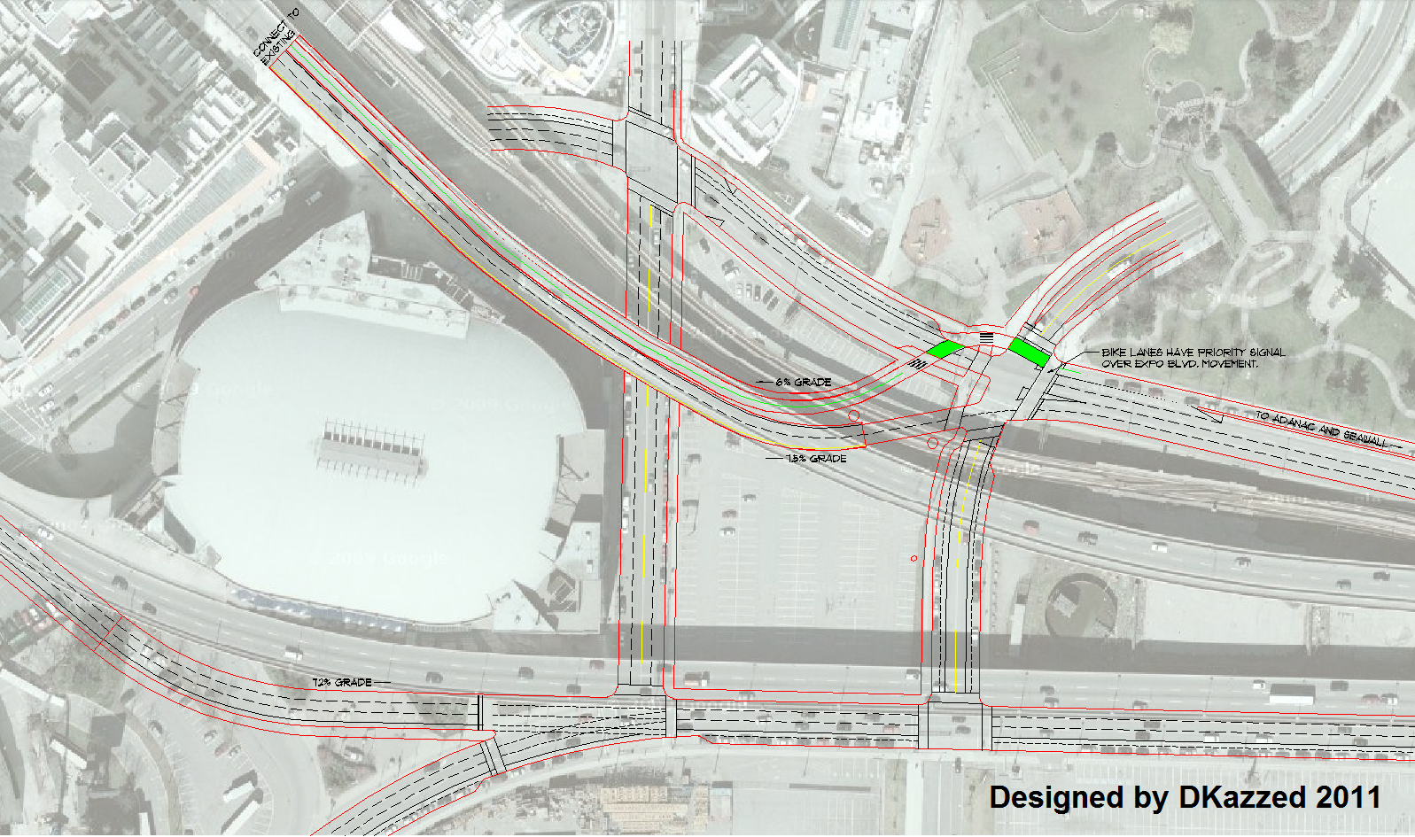
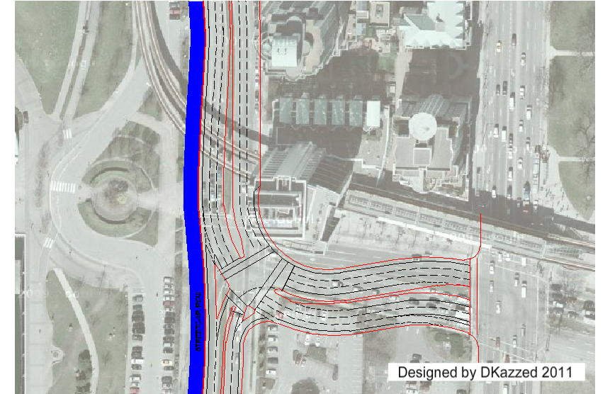
The curved connection I settled on is what I came up with to compensate for the limitations of the site.
The cost is $0.0823B/lane-km, using the costs of only the marginal tunnel costs themselves as a baseline to calaculate it, and the tunnels also have a $717.8M fixed cost.
For the planned 8 lane NS tunnel (2 lanes commuter rail, 6 lanes general traffic) the cost is on the lines of $3.35B (2014$). The cost of the 6 lane option, meanwhile (4 lanes general traffic, 2 lanes commuter rail, or 6 lanes general traffic) would be about $2.693B, both excluding the cost of adding the commuter rail proper (only the space would be added).
Adding the cost of the conector Hamilton Street expansion and extension results in a ~$7.8M increase in cost. It's impossible to find the cost of the land reclaimation needed, property aquisition costs, or environmental mitigation costs on Mckay Creek. Either way, the tunnel is by far the biggest cost and is pretty much a good indicator of the overall cost, -5%.
For comparison, the Lonsdale Line shown here (
http://skyscraperpage.com/forum/show....php?p=8372660) is $2.4B-$3B (2015$), depending on how you crunch the numbers.
There's no way to know for sure the costs of the actual thing without a *modern* feasibility study into the idea, but this should give an idea of potential costs.
BTW, the proposed commuter rail I'm planning here would be similar to something like Toronto's proposed Smarttrack, though modified to be diesel-operating.
As for the Main Street bridge across the North Fraser, I've decided to give up on that en lieu of just expanding both Prior Street back to 4 lanes and expanding the Knight Street Freeway and bridge to 6 lanes.
On the Map:
Red: Property aquisitions required (ONLY FOR the ROADs)
Blue: Commuter Rail (Dark Blue is Tunnel)
Grey: Hamilton/Main Street (Dark Grey is Tunnel)
Black: Reclaimed Land
EXTRA
Cost of new section of Hamilton Ave ($0.495M)
Cost of 216th Street interchange ($6.194M)
Cost of expanded section of Hamilton Ave ($1.0998M)
I can't add cost of properties now due to the DNV's assessment service being down.
Sigh.
I spent way too much time on this.
Funny thing, in the diagram on the "FINAL" GMB study, it seems a bored tunnel approach can fit on Deas Island (though a tight fit). I'm not sure as to the rationale behind extending the tunnel and thus making the bored tunnel option worse.

Side Notes:
-I'm gonna add this to my master plan at some point- it doesn't seem
completely unreasonable to advocate for in my opinion.
-The 4 road lane option also assumes most traffic flows into a 8+ lane Upper Levels and Skytrain to the North Shore, along with no development above the 1200ft limit to mitigate traffic congestion.
-The curve is to avoid a deep section in the center of Vancouver Harbour.
-New roads and Commuter Rail are not to scale.
-A Kingsway Extension would be built to divert more East-West traffic away from Main Street.
-Cordova and Powell west of Main would be expanded by 1 lane each (by taking it from parking) to accommodate the new traffic flow.
-LGB and the LGB Road would be closed under current plans by the City of Vancouver.
-There would be a significant negative environmental impact on MacKay Creek.
Sources:
(GMT)
https://blog.gov.bc.ca/app/uploads/s...FINAL_corr.pdf
https://engage.gov.bc.ca/app/uploads...-July-2016.pdf
https://blog.midwestind.com/cost-of-building-road/


 Prev
Prev


 Linear Mode
