HomeDiagramsDatabaseMapsForum About
     

Go Back   SkyscraperPage Forum > Regional Sections > Canada > Alberta & British Columbia > Vancouver > Transportation & Infrastructure


Reply

 
Thread Tools Display Modes
     
     
  #2041  
Old Posted Dec 4, 2017, 10:57 PM
SpongeG's Avatar
SpongeG SpongeG is offline
Registered User
 
Join Date: Jun 2006
Location: Coquitlam
Posts: 39,154
Quote:
Originally Posted by EastVanMark View Post
Ironic, seeing as Robson street only developed as a shopping destination because businesses fled away from another pedestrian mall to a street that wasn't a pedestrian mall.
london is most likely making oxford street into a pedestrian street, seems to be coming back in

Video Link
__________________
belowitall
Reply With Quote
     
     
  #2042  
Old Posted Dec 4, 2017, 11:44 PM
aberdeen5698's Avatar
aberdeen5698 aberdeen5698 is offline
Registered User
 
Join Date: May 2010
Posts: 4,435
Quote:
Originally Posted by whatnext View Post
What part of the tight street grid are you referring to?
You can't get to Stanley Park through downtown without going right through the part of the city with the least road space.
Reply With Quote
     
     
  #2043  
Old Posted Dec 4, 2017, 11:51 PM
whatnext whatnext is offline
Registered User
 
Join Date: Feb 2009
Location: Vancouver
Posts: 22,286
Quote:
Originally Posted by aberdeen5698 View Post
You can't get to Stanley Park through downtown without going right through the part of the city with the least road space.
Which part? As I said, it looks to me like after Gastown the alignment goes down Cordova, not the busiest of streets. That could take you all the way to Devonian Park. Take away a strip of that underused park (shock! horror!) and you're at Stanley Park.

Last edited by whatnext; Dec 5, 2017 at 12:22 AM. Reason: spelling
Reply With Quote
     
     
  #2044  
Old Posted Dec 5, 2017, 12:11 AM
officedweller officedweller is offline
Registered User
 
Join Date: Jul 2001
Location: Vancouver
Posts: 38,361
Quote:
Originally Posted by EastVanMark View Post
Ironic, seeing as Robson street only developed as a shopping destination because businesses fled away from another pedestrian mall to a street that wasn't a pedestrian mall.
I recall reading a number of years ago that Granville wasn't the best candidate for a pedestrian mall because it was always a bit seedy (at least its southern end) and wasn't a shopping high street.

Mind you, Robson wasn't a shopping high street in the mid 1970s either - it was more a local shopping street.

Granville was probably chosen more because of the transit efficiencies.

The current question would be - if you pedestrianized Robson St., would it revive it?

Quote:
Originally Posted by aberdeen5698 View Post
You can't get to Stanley Park through downtown without going right through the part of the city with the least road space.
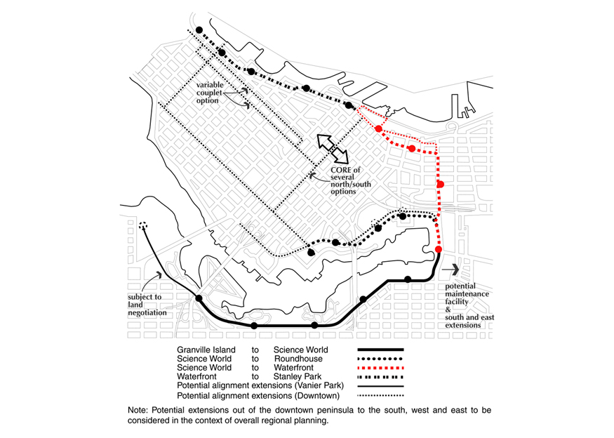
I think the City's solution would be to allow the streetcar to run down a pedestrianized Water Street
- but the plans are /were for a couplet system, with one way lines on each of Cordova and Water Streets.
If Water St. becomes pedestrianized, I wonder if Water St. would become a 2-way streetcar route?
Mind you that could prevent the street from being closed off for festivals, etc.

Remember that the Water/Cordova St. route hits the Waterfront Station Transit Hub nicely.

I do agree that it will be a feeder to and from SkyTrain:
@ Arbutus & Broadway Station
@ Olympic Village Station
@ Main St. Science World Station
@ Waterfront Station
@ Yaletown Roundhouse Station

But will also provide missing "last km" links to:
- Granville Island
- Chinatown/Gastown
- BC Place / Rogers Arena (from Canada Line)
- Stanley Park

Last edited by officedweller; Dec 5, 2017 at 12:23 AM.
Reply With Quote
     
     
  #2045  
Old Posted Dec 5, 2017, 12:27 AM
CanSpice's Avatar
CanSpice CanSpice is offline
Registered User
 
Join Date: Dec 2014
Location: New Westminster, BC
Posts: 2,192
Quote:
Originally Posted by whatnext View Post
Which part? As I said, it looks to me like after Gastown the alignment goes down Cordova, not the busiest of streets. That could take you all the way to Devonian Park. Take away a strip of that underused park (shock! horror!) and you're at Stanley Park.
How do you get from Bute to Devonian Park? I can't see any way through there that doesn't include going down Georgia.
Reply With Quote
     
     
  #2046  
Old Posted Dec 5, 2017, 1:10 AM
officedweller officedweller is offline
Registered User
 
Join Date: Jul 2001
Location: Vancouver
Posts: 38,361
For the streetcar there's a couple of jogs to get from Cordova to Hastings to Georgia:


http://www.via-architecture.com/proj...ver-streetcar/


http://bids.vancouver.ca/bidopp/RFP/RFP-PS20171493.htm
Reply With Quote
     
     
  #2047  
Old Posted Dec 5, 2017, 1:17 AM
whatnext whatnext is offline
Registered User
 
Join Date: Feb 2009
Location: Vancouver
Posts: 22,286
Quote:
Originally Posted by CanSpice View Post
How do you get from Bute to Devonian Park? I can't see any way through there that doesn't include going down Georgia.
You're right, they would have to cut up to Hastings and then cut up to run alongside Georgia at the Bayshore.
Reply With Quote
     
     
  #2048  
Old Posted Dec 5, 2017, 4:42 AM
Migrant_Coconut's Avatar
Migrant_Coconut Migrant_Coconut is offline
Registered User
 
Join Date: Oct 2015
Location: Kitsilano/Fairview
Posts: 8,397
Quote:
Originally Posted by whatnext View Post
Take away a strip of that underused park (shock! horror!) and you're at Stanley Park.
But they WON'T take a strip off the park - you know that as much as we do. They'll put the tracks on Georgia, either with a median or cutting into traffic.
Reply With Quote
     
     
  #2049  
Old Posted Dec 5, 2017, 4:51 AM
Metro-One's Avatar
Metro-One Metro-One is online now
Registered User
 
Join Date: Sep 2008
Location: Japan
Posts: 16,837
Phase 0 and the Arbutus Streetcar are the only two portions that should be built. Maybe phase 1 to Waterfront Station.

After that the other alignments are pretty terrible.
__________________
Bridging the Gap
Check out my Flickr: https://www.flickr.com/photos/306346...h/29495547810/ and Youtube channel https://www.youtube.com/channel/UCV0...lhxXFxuAey_q6Q
Reply With Quote
     
     
  #2050  
Old Posted Dec 5, 2017, 5:08 AM
Migrant_Coconut's Avatar
Migrant_Coconut Migrant_Coconut is offline
Registered User
 
Join Date: Oct 2015
Location: Kitsilano/Fairview
Posts: 8,397
Quote:
Originally Posted by Metro-One View Post
Phase 0 and the Arbutus Streetcar are the only two portions that should be built. Maybe phase 1 to Waterfront Station.

After that the other alignments are pretty terrible.
Pretty much. The Pacific Extension has potential if somehow they find enough ROW space, but it seems best to leave Stanley Park for the Hastings SkyTrain.

Perhaps instead of trying to force their way down Georgia, they could follow Bute through the West End (with a connection to the future Hastings Line) down to Sunset Beach and possibly further along to Denman-Davie? Hell, half the traffic on Beach Avenue is looking for parking anyway.
Reply With Quote
     
     
  #2051  
Old Posted Dec 5, 2017, 10:54 PM
jsbertram jsbertram is offline
Registered User
 
Join Date: Sep 2009
Posts: 3,245
another way to get downtown is to tunnel from fir @ 2nd under pennyfarthing dr (swinging around the harbour cove and the credit union buildings), lining up with burrard st

run under false creek east of the burrard bridge, and run under burrard from false creek waterfront, north to the harbour.

its been done before with canada line running from olympic stn to yaletown stn, boring below and between the newport quay & connaught co-op buildings, under false creek, to marina side cresc @ davie. and under davie

faster to run in a tunnel under burrard with the usual stops at davie, nelson, robson, bentall ctr, convention ctr.
Reply With Quote
     
     
  #2052  
Old Posted Dec 6, 2017, 12:01 AM
officedweller officedweller is offline
Registered User
 
Join Date: Jul 2001
Location: Vancouver
Posts: 38,361
If they want a direct connection from Arbutus to downtown, they would just place the tracks on Granville Bridge
- they're going to eliminate 2 lanes anyways.
That's assuming the bridge is strong enough (or can be strengthened).
Reply With Quote
     
     
  #2053  
Old Posted Dec 6, 2017, 1:49 AM
cganuelas1995 cganuelas1995 is offline
Registered User
 
Join Date: Jan 2017
Posts: 1,277
Quote:
Originally Posted by officedweller View Post
If they want a direct connection from Arbutus to downtown, they would just place the tracks on Granville Bridge
- they're going to eliminate 2 lanes anyways.
That's assuming the bridge is strong enough (or can be strengthened).
The first two were strong enough for streetcars. And the first one was made of timber, IIRC.
Reply With Quote
     
     
  #2054  
Old Posted Dec 6, 2017, 5:12 AM
Dave2 Dave2 is offline
Registered User
 
Join Date: Dec 2007
Posts: 511
L
Quote:
Originally Posted by cganuelas1995 View Post
The first two were strong enough for streetcars. And the first one was made of timber, IIRC.
First Granville Bridge. The streetcars ran alongside on a trestle that was built a year after the 1889 bridge.

The second 1909 bridge is visible on the left.

http://searcharchives.vancouver.ca/o...street-bridges

Last edited by Dave2; Dec 7, 2017 at 6:37 AM.
Reply With Quote
     
     
  #2055  
Old Posted Dec 6, 2017, 8:09 AM
officedweller officedweller is offline
Registered User
 
Join Date: Jul 2001
Location: Vancouver
Posts: 38,361
Just noticed this from the RFP:


Quote:
4.3 The following existing issues or challenges have been identified as related to the current proposed streetcar routing:

* The existing rail line between Olympic Canada Line Station and
Granville Island is based on a historic freight service. It will be revisited
as part of the entire new transportation network for False Creek South.
The Right of Way (“ROW”) is in a cut for part of its length which could
make connections at stations challenging. The alignment by the Olympic
Canada Line Station is narrow;

* 1st Ave through Olympic Village has a median that was originally
intended to accommodate a streetcar. Currently there is a strong desire
for All Ages and Abilities (“AAA”) cycling facilities along this section of
the route, as per direction in Transportation 2040.
Further investigation
will determine the final design for this section and whether the
streetcar is in a dedicated right of way or in mixed traffic with
additional traffic calming to ensure enough transit priority is maintained
for the streetcar as compared to the dedicated median; and

* Similarly, the alignment on Quebec Street from 1st Avenue to Pacific
Boulevard was envisaged to be in a dedicated right of way on the west
side of the street. As part of the North East False Creek master
planning, it was determined that the streetcar would run primarily in
mixed traffic through this section (north of Terminal).
Transit priority
measures need to be considered to finalize the best possible reliability
and station placements. Through ongoing design of the streets in North
East False Creek, the intention is to preserve the ability to integrate a
future streetcar system in mixed traffic. Work on this continues but
some constraints exist which will need to be addressed in the future.

These are some of the changes and challenges that the feasibility study will
need to address. It is anticipated that additional challenges will emerge, and
need to be addressed, as the study progresses.

4.4 In addition, the following four areas represent proposed changes or alterations
to the proposed streetcar routing. Consideration of these should be included in
the study.

* Arbutus Greenway Connections. Consideration should be given as to how
the downtown streetcar should connect to the Arbutus Greenway
Streetcar;

* Quebec Street to Broadway. A possible connection along Quebec Street
from 1st Avenue to Broadway should be considered, in order to provide a
direct connection to the proposed Millennium Line extension
;

* Hastings Street/ Georgia Street. Consideration should be given to
options including the shortening the end of the streetcar line on
Hastings Street rather than extending it onto West Georgia Street, or
exploring how the streetcar would operate in transit lanes on part of
Georgia Street.
This is due to other anticipated walking, cycling, transit
& public realm demands on West Georgia Street; and

* The streetcar maintenance facility was originally planned to be located
under the viaducts. The current thinking is to locate the facility within
the False Creek Flats, accessed across Main Street at 1st Avenue. This
concept will require investigation to ensure it is feasible and desirable.
Storage tracks along the Arbutus Corridor and possibly a maintenance
facility should also be explored.
http://bids.vancouver.ca/bidopp/RFP/RFP-PS20171493.htm
Reply With Quote
     
     
  #2056  
Old Posted Dec 6, 2017, 8:20 AM
Metro-One's Avatar
Metro-One Metro-One is online now
Registered User
 
Join Date: Sep 2008
Location: Japan
Posts: 16,837
Holy fuck!

Now they want to actually downgrade the sections that were going to be done correctly?

Seriously? not using the existing rail line ROW between Granville Island and the Canada Line?

Intentionally mixing traffic where space has been reserved for a separate RoW???

Seriously, these ideas along with the the Surrey LRT (Streetcar, lets be serious here) are very troubling.

It seems that the only mode of transportation these days that is entitled to its own right of way in our region cycling...

I want this "one size fits all, mix pedestrians / cars / trams / trains etc... together as much as possible using surface roads only (without scrambles I might add)" urbanization fad to die a quick death.

Not saying that everything must always be separate everywhere, far from it, but we have gone a little to far the other way now in our planning and it is getting frustrating. Sometimes pedestrian overpasses as useful. Sometimes an elevated road is useful. Sometimes an underground connection between train stations is useful... And sometimes (all the time) a train running separate from pedestrian and vehicle traffic as much as possible is a better idea...
__________________
Bridging the Gap
Check out my Flickr: https://www.flickr.com/photos/306346...h/29495547810/ and Youtube channel https://www.youtube.com/channel/UCV0...lhxXFxuAey_q6Q
Reply With Quote
     
     
  #2057  
Old Posted Dec 6, 2017, 2:51 PM
WarrenC12 WarrenC12 is offline
Registered User
 
Join Date: May 2007
Location: East OV!
Posts: 21,693
Some odd details in there, but I'll wait for the final report to judge it.

I don't think they are eliminating the Granville Island connection, just highlighting how narrow it is. The Olympic demonstration line was single tracked if you recall.

As for Quebec from 1st to Broadway, that's a steep hill... connecting to the Canada Line, and Expo line should be plenty, especially if they connect to multiple stations on each line.
Reply With Quote
     
     
  #2058  
Old Posted Dec 6, 2017, 3:42 PM
Jebby's Avatar
Jebby Jebby is offline
........
 
Join Date: Dec 2010
Location: Mexico City
Posts: 3,307
Quote:
Originally Posted by WarrenC12 View Post
I don't think they are eliminating the Granville Island connection, just highlighting how narrow it is. The Olympic demonstration line was single tracked if you recall.
Yes, but it has space for double tracking. The existing track would just have to be shifted, but there's space.
__________________
In the heart of a busy metropolis skyscrapers are a vivid reminder of the constant yearning of the human spirit to rise to God
Reply With Quote
     
     
  #2059  
Old Posted Dec 6, 2017, 4:03 PM
cornholio cornholio is offline
Registered User
 
Join Date: Jun 2006
Posts: 3,911
I don't think it matters where you fall on the ttransportation spectrum debate. This plan is troubling. When you have dedicated rights of way you use them. Also there is no justification to re-purpose those rights of ways to anything but what they are intended for. There are parallel AAA routes in those areas already or what ever they want to call them with plenty of room for expansions.

Quote:
* The streetcar maintenance facility was originally planned to be located
under the viaducts. The current thinking is to locate the facility within
the False Creek Flats, accessed across Main Street at 1st Avenue. This
concept will require investigation to ensure it is feasible and desirable.
Storage tracks along the Arbutus Corridor and possibly a maintenance
facility should also be explored.
If they build this line they should be connecting it to the future Broadway line false creek flats section. It is the most logical connection in phase one as it would allow a Broadway line to street car line transfer and take people directly west along false creek before it re connects with the Broadway line at Arbutus. If the OMC yard would be located east of Main street (which seems logical) then you only have a couple hundred meters to get you to the Broadway line False creek station.
Reply With Quote
     
     
  #2060  
Old Posted Dec 6, 2017, 4:33 PM
WarrenC12 WarrenC12 is offline
Registered User
 
Join Date: May 2007
Location: East OV!
Posts: 21,693
Quote:
Originally Posted by Jebby View Post
Yes, but it has space for double tracking. The existing track would just have to be shifted, but there's space.
How can you say that with confidence and without knowing the exact property lines?
Reply With Quote
     
     
This discussion thread continues

Use the page links to the lower-right to go to the next page for additional posts
 
 
Reply

Go Back   SkyscraperPage Forum > Regional Sections > Canada > Alberta & British Columbia > Vancouver > Transportation & Infrastructure
Forum Jump


Forum Jump


All times are GMT. The time now is 9:05 AM.

     
SkyscraperPage.com - Archive - Privacy Statement - Top

Powered by vBulletin® Version 3.8.7
Copyright ©2000 - 2024, vBulletin Solutions, Inc.