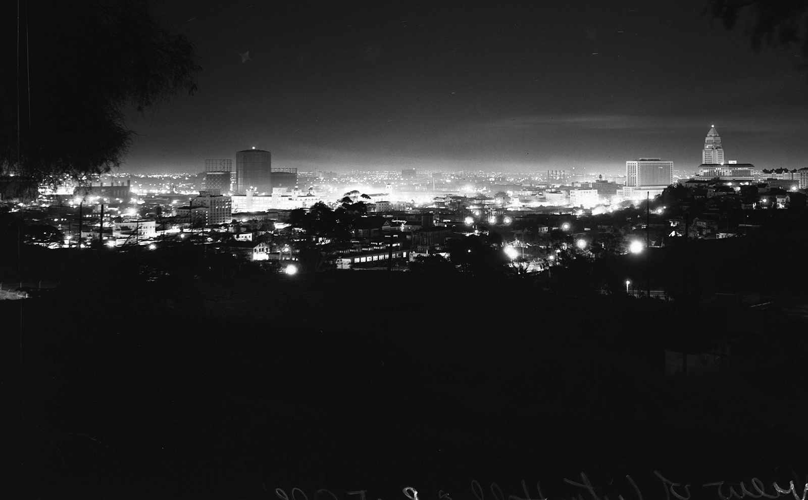
In this post I'll post some "now" versions of e_r's inaugural photo on NLA.
First, a little background info about how I found the location. In a post here a year or so ago, when I floated the idea of capturing a modern version of this image, ProphetM replied, suggesting the area around Lilac Terrace and Dodger Stadium. An initial field trip to Lilac Terrace proved that he was entirely correct. Predating the stadium by many years, Lilac Terrace is an old street that appears on many early maps. It even seems to appear (albeit un-named) on the 1909 hand-drawn aerial that we've seen here at times.
While Lilac Terrace allows easy access to the right location, I quickly learned that I couldn't get my now photo from that street -- a large Fire Dept. training tower and numerous trees now block the view. There's a mostly bare hillside above Lilac, but access is blocked by a chain link fence and many NO TRESPASSING signs are posted. So I started looking at locations around the parking lots at the stadium. The Dodgers had several night games last month and I found that an hour or so after the games begin, you can enter the lots without paying and kind of do your thing. A few spots around the stadium seemed promising but in each case, trees and bushes stopped me from getting the right view. Also, I realized that all the possible stadium spots were too high, and gave the wrong perspective.
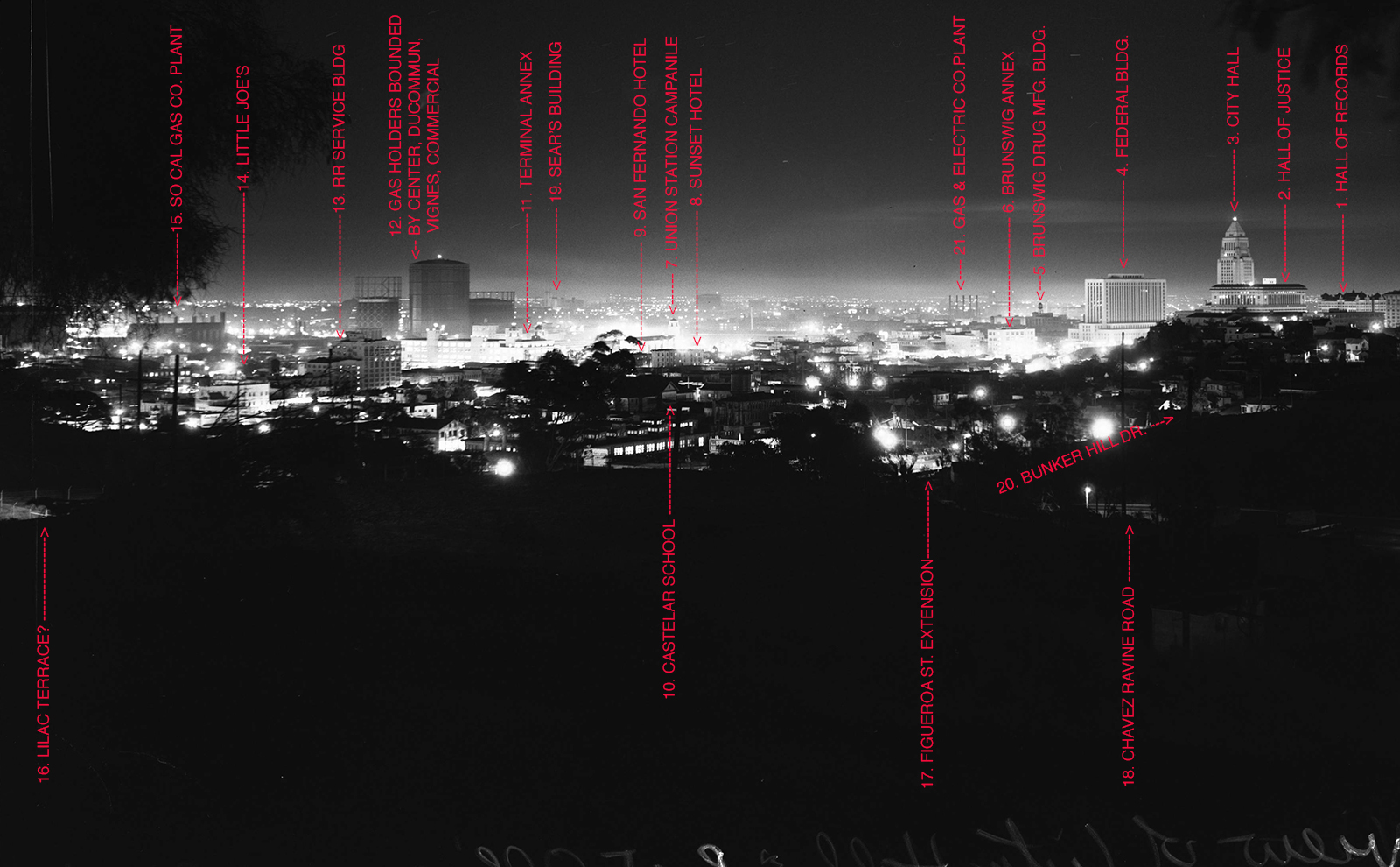
After a few more visits, I found a hidden opening in the fence, which allowed access to the hillside between Lilac Terrace and the stadium. Two clues in the original photograph helped me pinpoint the best spot. If you look closely, you can see that the corner of the upper left roof line of the Hall Of Justice lines up very closely with the left edge of City Hall. Also, 7 1/2 stories of the middle section of City Hall are visible above the Hall Of Justice. Hiking around the hillside while checking these details with binoculars, I found an unobstructed spot with almost exactly the same view. There's a paved pathway there, which may have been built for fire access or to manage water runoff. Over the course of several days and nights this became "my spot". I believe that the original photographer stood either in this same spot, or atop the LAFD fire tower.
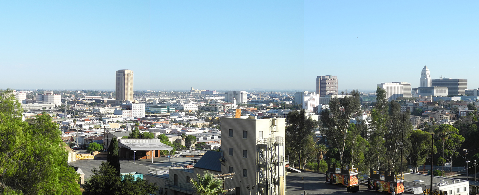
So with that introduction, here are the original photo with and without annotations, my daytime photo with and without annotations, and a night time photo. I hasten to add that the night shot was
not taken by me, but by my friend Joe Sidore. (I learned that night time skylines are
really hard to capture properly. With my limited skill set and mid-range camera, the results were disappointing. Joe, thanks for saving me!)
 http://digitallibrary.usc.edu/cdm/se...1/order/nosort
 http://digitallibrary.usc.edu/cdm/se...1/order/nosort
The culmination of my little project, this wonderful night time view, which I won't compromise with graphics or text:
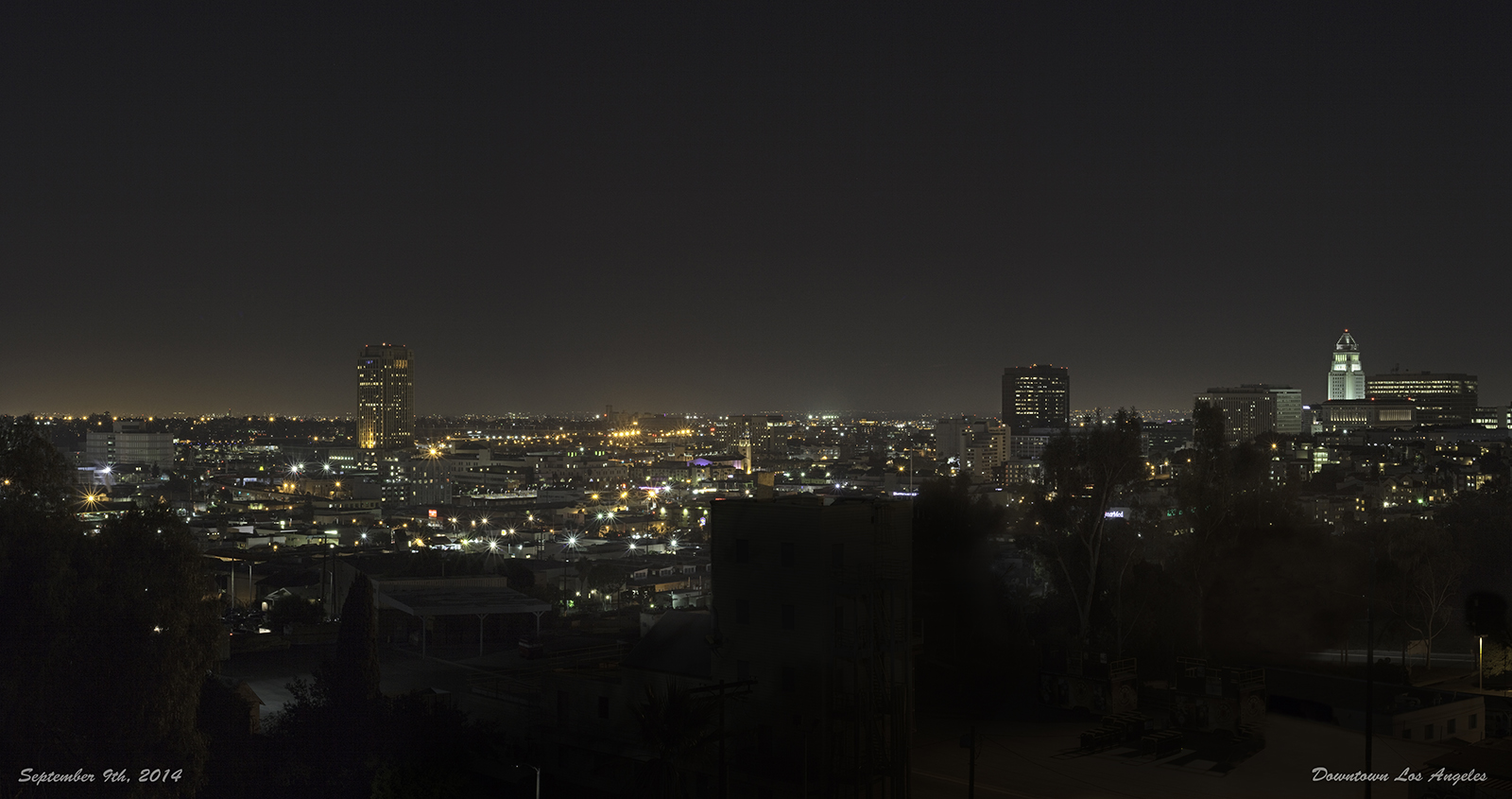
Joe Sidore (Thank you Joe, for this fantastic contribution to the thread!)
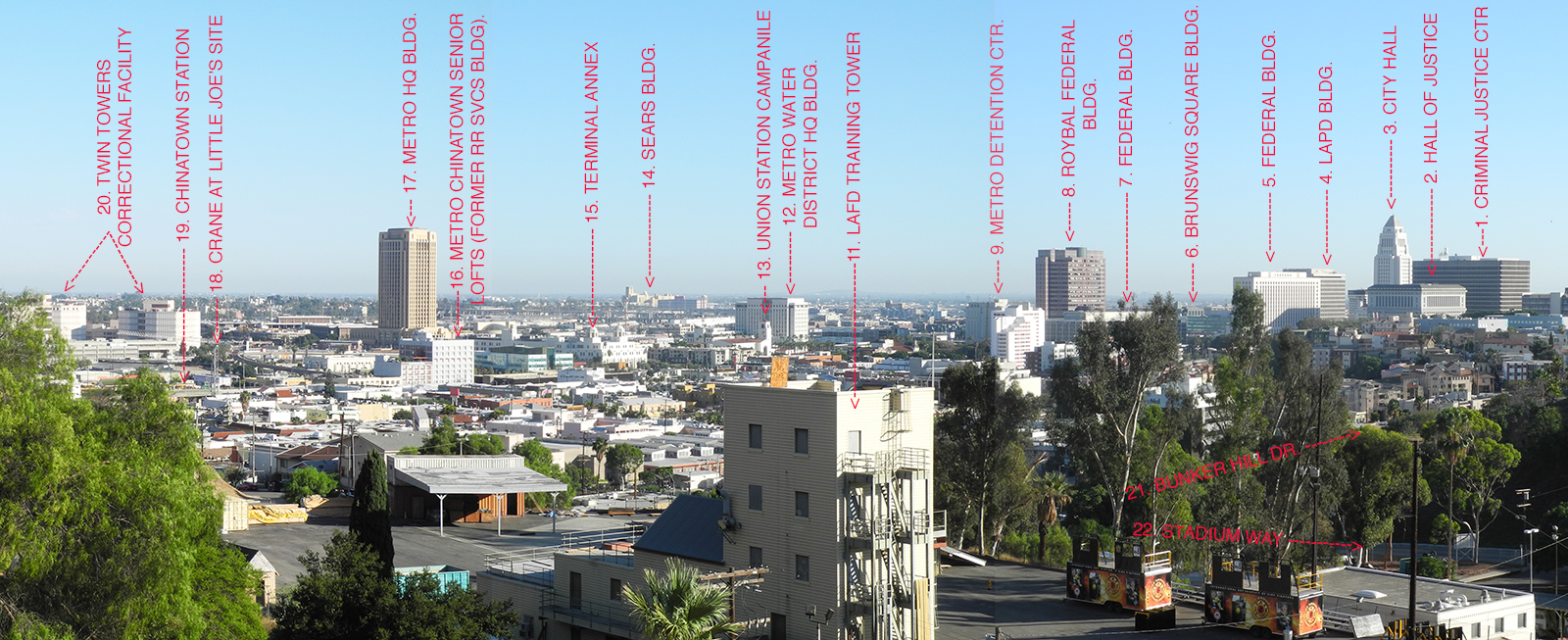
My daytime photo, with annotations:
My photo
And without:
My photo
I don't think much explanation is needed but referring to the daytime shot; some brief notes:
#8, the Roybal Federal Bldg., and #9, the Metro Detention Center, are near the southwest corner of Alameda and Aliso Streets.
#11, the LAFD tower, is part of a large Fire Department training center. (That campus is open to the public and is quite interesting, in and of itself. There's a 9/11 memorial near the entrance with a large piece of steel framework that was salvaged from the World Trade Center. More on this in a future post, maybe.)
#12, the new Water District building, is between Union Station and the 101 freeway.
#17, the new Metro HQ building, is behind Union Station, just south of Cesar Chavez Ave.
#19, the new Chinatown Gold Line station, is at the northwest corner of Spring and College streets.
#20, the sprawling Twin Towers Correctional Facility, is near the southeast corner of Bauchet and Vignes streets.
One aspect of this project disappointed me. Despite much effort, I was unable to identify many of the buildings in Chinatown, or any of the buildings in the north Bunker Hill area. Though many of these structures are clearly visible in the original shot, I couldn't really match any of them up with the homes and businesses that still stand in this area. I walked all of the streets in that area, enlargements of the original photo in hand, hoping to find just one -- without success. Maybe someone else can identify one or two that survive.
Thanks again to all who helped!


 Prev
Prev


 Good find FredH.


 Linear Mode
