HomeDiagramsDatabaseMapsForum About
     

Go Back   SkyscraperPage Forum > Regional Sections > Canada > Alberta & British Columbia > Vancouver > Transportation & Infrastructure


Reply

 
Thread Tools Display Modes
     
     
  #181  
Old Posted Oct 24, 2009, 4:21 AM
Tappen Tappen is offline
Registered User
 
Join Date: Oct 2009
Posts: 3
I thought it was painfully obvious. But I guess not.

Quote:
Comparing Vancouver to Los Angeles is like comparing Victoria to Vancouver-there is no comparison. Los Angeles is six times the population of Vancouver and as it is, Vancouver has smog. Had Los Angeles not built all those freeways the smog would be even worse.
I'm having trouble with that. A less car-reliant, more compact Los Angeles would produce more smog? ...how?
Reply With Quote
     
     
  #182  
Old Posted Oct 24, 2009, 4:34 AM
geoff's two cents geoff's two cents is offline
Registered User
 
Join Date: Jul 2008
Posts: 504
Quote:
Originally Posted by allan_kuan View Post
You may want to state that clearly at the very bottom of the post in some hidden or italicized font. Few people would have been able to catch that sarcasm. = \
Righto. My sincere apologies, Allen.
Reply With Quote
     
     
  #183  
Old Posted Oct 24, 2009, 4:37 AM
Metro-One's Avatar
Metro-One Metro-One is offline
Registered User
 
Join Date: Sep 2008
Location: Japan
Posts: 16,834
Yeah, that is one of the things that sucks about these forums, no one can hear your tone, hehe.
__________________
Bridging the Gap
Check out my Flickr: https://www.flickr.com/photos/306346...h/29495547810/ and Youtube channel https://www.youtube.com/channel/UCV0...lhxXFxuAey_q6Q
Reply With Quote
     
     
  #184  
Old Posted Oct 24, 2009, 4:54 AM
racc racc is offline
BANNED
 
Join Date: Oct 2008
Posts: 1,241
Quote:
Originally Posted by sacrifice333 View Post
Tearing down the Dunsmuir and Georgia viaducts may make sense... but with the Spectrum development complete and heavily influenced by the existing viaducts... removal of those viaducts would significantly change that development and it's interaction with "street level".

hmm....
There is no reason why the entire length of the Viaducts would need to be torn down. Just keep the small portions by Spectrum. Problem solved. It is much more fun to think of solutions rather than excuses.
Reply With Quote
     
     
  #185  
Old Posted Oct 24, 2009, 5:03 AM
deasine deasine is offline
Vancouver Moderator
 
Join Date: Mar 2007
Posts: 5,747
Quote:
Originally Posted by racc View Post
There is no reason why the entire length of the Viaducts would need to be torn down. Just keep the small portions by Spectrum. Problem solved. It is much more fun to think of solutions rather than excuses.
I'm still waiting for visuals and diagrams (ones that makes sense), as what many other members are waiting for.
Reply With Quote
     
     
  #186  
Old Posted Oct 24, 2009, 6:25 AM
Dave2 Dave2 is offline
Registered User
 
Join Date: Dec 2007
Posts: 511
Quote:
Originally Posted by officedweller View Post
Cool - Thanks!


Note "Highway 401" on that map. That's when it was legitimately called the 401.
Back in the late 80s, just before the Cassiar tunnel was built, the Big Green Sign at the start of the freeway had a green maple leaf 401 sign showing, as the green maple leaf 1 sticker had fallen off.

re: this thread, an interesting photo from the VPL collection (why can't I find this on the web) from 1971 that shows the Georgia Viaduct with 2-way traffic, the 1915 era Hart McHarg viaduct awaiting demolition, and the pillars of the Dunsmuir Viaduct. Note the Gulf gas station next to the Armory
Reply With Quote
     
     
  #187  
Old Posted Oct 24, 2009, 7:12 AM
Metro-One's Avatar
Metro-One Metro-One is offline
Registered User
 
Join Date: Sep 2008
Location: Japan
Posts: 16,834
Wow, that is an amazing find, thanks Dave2.
__________________
Bridging the Gap
Check out my Flickr: https://www.flickr.com/photos/306346...h/29495547810/ and Youtube channel https://www.youtube.com/channel/UCV0...lhxXFxuAey_q6Q
Reply With Quote
     
     
  #188  
Old Posted Oct 24, 2009, 7:37 AM
Zassk Zassk is offline
Registered User
 
Join Date: Sep 2009
Posts: 2,303
Look at the railyards in that picture - it really puts the evolution of downtown in perspective.
Reply With Quote
     
     
  #189  
Old Posted Oct 24, 2009, 8:17 AM
Dave2 Dave2 is offline
Registered User
 
Join Date: Dec 2007
Posts: 511
Quote:
Originally Posted by Zassk View Post
Look at the railyards in that picture - it really puts the evolution of downtown in perspective.
The 1915 viaduct was constructed over water

There's many interesting photos at the Vancouver Archives site, this shot has downtown in the background
Reply With Quote
     
     
  #190  
Old Posted Oct 24, 2009, 8:24 AM
Dave2 Dave2 is offline
Registered User
 
Join Date: Dec 2007
Posts: 511
Site of Stadium Skytrain station
Reply With Quote
     
     
  #191  
Old Posted Oct 24, 2009, 5:11 PM
Stingray2004's Avatar
Stingray2004 Stingray2004 is offline
Registered User
 
Join Date: Jan 2004
Location: White Rock, BC (Metro Vancouver)
Posts: 3,145
Quote:
Originally Posted by Dave2 View Post
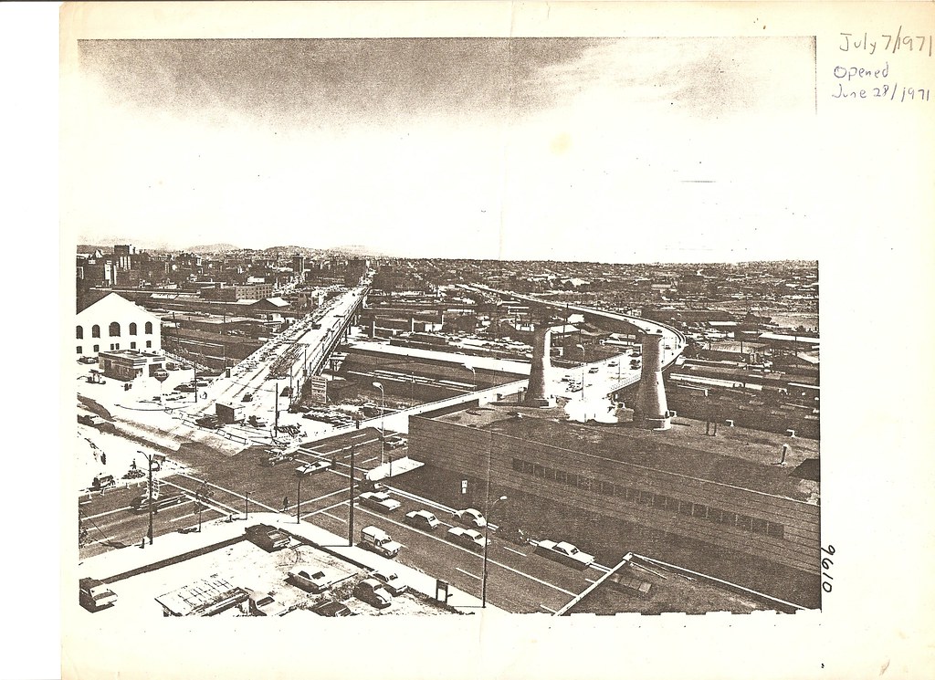
Nice find! I've always wondered how the Georgia Viaduct could have a perfectly straight connection to Georgia St. when the old viaduct was still extant. And there's your answer. The old Georgia viaduct was offset from Georgia St. at the top of the escarpment.

At the Vancouver archives last week, newspaper clippings showed the new Georgia Viaduct was temporarily two-lane eastbound/ one-lane westbound, with the eastbound lanes only permitted to utilize the Main St. off-ramp.

I also stumbled across a letter from Mayor Tom Campbell apologizing to then Archbishop James Carney for the "rabble-rousing" hippies at the official opening. Photos showed your stereotypical 1960's hippies with protest signs heckling Campbell and Carney who were in the official opening vehicle.
Reply With Quote
     
     
  #192  
Old Posted Oct 24, 2009, 5:17 PM
Stingray2004's Avatar
Stingray2004 Stingray2004 is offline
Registered User
 
Join Date: Jan 2004
Location: White Rock, BC (Metro Vancouver)
Posts: 3,145
For those proponents of tearing down the viaducts, why is there also not a proposal to tear down the Hemlock/Fir St. on/off ramps to the Granville Street Bridge?

The Granville Street Bridge has the ghosts of a 1950's freeway design written all over it.

The Fir Street off-ramp (viaduct) itself is relatively not that much shorter than the Georgia viaducts.

Also, getting rid of the loop ramps would free-up a cornucopia of land to construct some high-density towers.


Source: Pricetags
Reply With Quote
     
     
  #193  
Old Posted Oct 24, 2009, 5:45 PM
CBeats CBeats is offline
Registered User
 
Join Date: Mar 2009
Posts: 421
Wink

Quote:
Originally Posted by allan_kuan View Post
You may want to state that clearly at the very bottom of the post in some hidden or italicized font. Few people would have been able to catch that sarcasm. = \
Hahaha I can't believe how many people didn't understand his post! I thought it was hilarious, but then there are all the responses taking his post literally...come on guys! It's not that difficult to figure out what sarcasm is... Ps- in that pic of the granville street bridge, you can see the old straight bridge that goes right across granville island. Removing it must have had quite an impact on the area
Reply With Quote
     
     
  #194  
Old Posted Oct 24, 2009, 5:48 PM
trofirhen trofirhen is offline
Registered User
 
Join Date: Oct 2008
Posts: 8,845
Quote:
Originally Posted by Stingray2004 View Post
For those proponents of tearing down the viaducts, why is there also not a proposal to tear down the Hemlock/Fir St. on/off ramps to the Granville Street Bridge?

The Granville Street Bridge has the ghosts of a 1950's freeway design written all over it.

The Fir Street off-ramp (viaduct) itself is relatively not that much shorter than the Georgia viaducts.

Also, getting rid of the loop ramps would free-up a cornucopia of land to construct some high-density towers.


Source: Pricetags

Everything you say is true. I have a question, though. The current on-ramp and off-ramp traffic at fir and hemlock?

If you take awy the viaducts, bridge access locally will still be in high demand

How do you see your rerouting of vehicular traffic, to and from downtown, in your plan?
Reply With Quote
     
     
  #195  
Old Posted Oct 24, 2009, 7:40 PM
Prometheus's Avatar
Prometheus Prometheus is offline
Reason and Freedom
 
Join Date: Jul 2009
Location: Vancouver/Toronto
Posts: 4,015
Quote:
Originally Posted by CBeats View Post
Ps- in that pic of the granville street bridge, you can see the old straight bridge that goes right across granville island. Removing it must have had quite an impact on the area
You can also see, to the west, the old railway bridge, which survived all the way to the early 1980s.

You can see it in this 1982 photo: http://www.globalairphotos.com/large...own/1982/071/2
Reply With Quote
     
     
  #196  
Old Posted Oct 24, 2009, 8:15 PM
biketrouble biketrouble is offline
Registered User
 
Join Date: Aug 2004
Posts: 188
Quote:
Originally Posted by Stingray2004 View Post
why is there also not a proposal to tear down the Hemlock/Fir St. on/off ramps to the Granville Street Bridge?
Personally - can you guess - I would be all over that, or at least discussing the pros and cons. I live pretty close to the Fir Street ramp and it is quite the blight on the landscape. I can see the logic of trying disperse traffic to Broadway, 12th and 16th, instead of having it all heading up Granville, but on the other hand doing that by feeding it all onto a residential street doesn't seem like the best idea the city ever had.

Still, bit of a straw man attempt - supporting demolishing one viaduct does not imply that one has to support demolishing every viaduct or onramp everywhere.
Reply With Quote
     
     
  #197  
Old Posted Oct 24, 2009, 11:24 PM
Millennium2002 Millennium2002 is offline
Registered User
 
Join Date: Jun 2009
Posts: 1,742
Looking at these photos it really amazes me to see how much Vancouver has changed since its founding... and especially the change it underwent over the last thirty years. It's a real eye-opener. O.O =O
Reply With Quote
     
     
  #198  
Old Posted Oct 25, 2009, 12:41 AM
racc racc is offline
BANNED
 
Join Date: Oct 2008
Posts: 1,241
Quote:
Originally Posted by allan_kuan View Post
Looking at these photos it really amazes me to see how much Vancouver has changed since its founding... and especially the change it underwent over the last thirty years. It's a real eye-opener. O.O =O
Viaducts come and viaducts go. The old pictures show the reasons why the Viaducts were built, they crossed railyards and water. With both of those gone, there is little need for them anymore.
Reply With Quote
     
     
  #199  
Old Posted Oct 25, 2009, 12:47 AM
GeeCee's Avatar
GeeCee GeeCee is offline
Registered User
 
Join Date: Jan 2009
Location: Port Coquitlam, BC
Posts: 2,816
Quote:
Originally Posted by racc View Post
Viaducts come and viaducts go. The old pictures show the reasons why the Viaducts were built, they crossed railyards and water. With both of those gone, there is little need for them anymore.
Unless you want to travel east or west into/out of the downtown peninsula by bus or private vehicle..
Reply With Quote
     
     
  #200  
Old Posted Oct 25, 2009, 2:17 AM
East Van East Van is offline
Registered
 
Join Date: Jan 2003
Location: PacificNorthWest
Posts: 713
Does anyone have links to pictures of Grandview Hwy north when it use to be an artery ? I think I remember a 3 way interchange somewhere west of Renfrew decades ago. Its like it should of continued west of Clark with something that didn't get built.
Reply With Quote
     
     
This discussion thread continues

Use the page links to the lower-right to go to the next page for additional posts
 
 
Reply

Go Back   SkyscraperPage Forum > Regional Sections > Canada > Alberta & British Columbia > Vancouver > Transportation & Infrastructure
Forum Jump


Forum Jump


All times are GMT. The time now is 3:40 PM.

     
SkyscraperPage.com - Archive - Privacy Statement - Top

Powered by vBulletin® Version 3.8.7
Copyright ©2000 - 2024, vBulletin Solutions, Inc.