HomeDiagramsDatabaseMapsForum About
     

Go Back   SkyscraperPage Forum > Photography Forums > My City Photos


Reply

 
Thread Tools Display Modes
     
     
  #1  
Old Posted Oct 24, 2007, 5:08 PM
Mopacs's Avatar
Mopacs Mopacs is offline
Austinite
 
Join Date: Jul 2002
Location: Austin.TX.USA
Posts: 4,585
Austin - Mt Bonnell and Westside Hills

At the request of several forumers, here are a series of photos I shot late yesterday from atop Austin's Mount Bonnell. This is the historic 'high' point of Austin (far eclipsed as the city has expanded westward into the Texas Hill country). Atop the peak is a very popular city park with gorgeous panoramic views of downtown Austin and the Colorado River valley.

So here goes... yesterday was a beautiful crisp fall day in Austin:


Looking up the Colorado River (Lake Austin) toward the Pennybacker suspension bridge (Loop 360):


Multi-million dollar lakeside mansions (Lance Armstrong once lived in this exclusive enclave):


Wide view


The waters, 400 ft below


The park and the valley


Looking SW


Sheer cliff


Closeup of the aforementioned Pennybacker Bridge, and Shepperd Mountain beyond.


Downtown Austin, to the SE. The city's new tallest building (360 Condiminiums) is rising to the right.


Closeup of the 44 story 360 and 29 story Monarch condo towers, under construction.


More of the western shots...


More Homes


This last shot is from the top of Shepperd Mountain (Mount Bonnell can be seen straight ahead, across the river (with the rock cliff at the top):

__________________
Austin.Texas.USA
Home of the 2005 National Champion Texas Longhorns
Reply With Quote
     
     
  #2  
Old Posted Oct 24, 2007, 5:21 PM
KevinFromTexas's Avatar
KevinFromTexas KevinFromTexas is offline
Meh
 
Join Date: Jul 2001
Location: Austin <------------> Birmingham?
Posts: 57,327
Beautiful. Thanks for posting those!
__________________
Conform or be cast out.
Reply With Quote
     
     
  #3  
Old Posted Oct 24, 2007, 6:06 PM
arbeiter's Avatar
arbeiter arbeiter is offline
passion for patterns
 
Join Date: Apr 2004
Location: San Francisco
Posts: 10,336
gives me a nostalgic feeling for my hometown! i remember the first time i saw a crackpipe was on the top of mount bonnell. those were the days.

i used to work near sheppard mountain at one of those high-tech office parks, as well. and i grew up off of 360, so this is all very much close to home for me.
__________________
you should know that I'm womanly wise
my website/blog. or, my flickr site.
Reply With Quote
     
     
  #4  
Old Posted Oct 24, 2007, 6:42 PM
DruidCity's Avatar
DruidCity DruidCity is offline
Registered User
 
Join Date: Aug 2002
Location: Tuscaloosa,AL
Posts: 3,381
Damn nice views !

For all the references to "Texas Hill Country" online (Google, etc), I've seen surprisingly few photos that really show off the terrain this well.

Quote:
Mount Bonnell... is the historic 'high' point of Austin (far eclipsed as the city has expanded westward into the Texas Hill country).
How high is the current highest point ?
__________________
Also representing San Marcos,TX and Baldwin Co, AL
Reply With Quote
     
     
  #5  
Old Posted Oct 24, 2007, 6:56 PM
Austinlee's Avatar
Austinlee Austinlee is offline
Chillin' in The Burgh
 
Join Date: Nov 2004
Location: Spring Hill, Pittsburgh
Posts: 13,095
This pictures is very pretty:


Hills and bridge in background; Mansions and river in foreground... Makes for a sweet picture.
Reply With Quote
     
     
  #6  
Old Posted Oct 24, 2007, 7:32 PM
Boris Boris is offline
Registered User
 
Join Date: Jan 2006
Posts: 1,730
I know it's been said above already, but,

Beautiful!!!
Reply With Quote
     
     
  #7  
Old Posted Oct 24, 2007, 7:35 PM
arbeiter's Avatar
arbeiter arbeiter is offline
passion for patterns
 
Join Date: Apr 2004
Location: San Francisco
Posts: 10,336
Quote:
Originally Posted by DruidCity View Post
Damn nice views !

For all the references to "Texas Hill Country" online (Google, etc), I've seen surprisingly few photos that really show off the terrain this well.


How high is the current highest point ?
The Hill Country varies in its "hilliness" - there are lots of downright flat parts of the Hill Country. Some of the hilliest parts of the Hill Country are right up against Austin's central core, which makes for nice pictures like this. I think Mount Bonnell is just under 800 feet, whereas downtown is about 450-500 feet. However, in the city limits of Austin, the Jollyville Plateau area (near the Cedar Park border) is about 1000 feet or even maybe slightly higher.

Mount Barker and Mount Larson, two nearby hills to Bonnell, are both around 950-1000 feet.

here's a picture I took about 3-3.5 years ago from Mount Larson. If you look closely you can see the skyline is much smaller than it is today:

__________________
you should know that I'm womanly wise
my website/blog. or, my flickr site.
Reply With Quote
     
     
  #8  
Old Posted Oct 24, 2007, 9:02 PM
DruidCity's Avatar
DruidCity DruidCity is offline
Registered User
 
Join Date: Aug 2002
Location: Tuscaloosa,AL
Posts: 3,381
Thanks. The elevation is similar to Birmingham, then.
The amount of the tree cover in the photos is also very nice.
__________________
Also representing San Marcos,TX and Baldwin Co, AL
Reply With Quote
     
     
  #9  
Old Posted Oct 24, 2007, 9:13 PM
arbeiter's Avatar
arbeiter arbeiter is offline
passion for patterns
 
Join Date: Apr 2004
Location: San Francisco
Posts: 10,336
Quote:
Originally Posted by DruidCity View Post
Thanks. The elevation is similar to Birmingham, then.
The amount of the tree cover in the photos is also very nice.
It is nice but kind of misleading. It's largely ashe juniper which barely grows taller than 15 feet, it's a very scrubby tree. It's kind of like a Texas version of chaparral - actual woodland areas are usually only found next to the water.
__________________
you should know that I'm womanly wise
my website/blog. or, my flickr site.
Reply With Quote
     
     
  #10  
Old Posted Oct 25, 2007, 1:25 AM
dharper6 dharper6 is offline
Closed account
 
Join Date: Nov 2006
Posts: 509
Quote:
Originally Posted by arbeiter View Post
It is nice but kind of misleading. It's largely ashe juniper which barely grows taller than 15 feet, it's a very scrubby tree. It's kind of like a Texas version of chaparral - actual woodland areas are usually only found next to the water.
True. A lot of it has to do with the limestone coming so close to the surface in the hills. Really close. The deep soils start immediately east of the escarpment, precipitation increases too, and tree height increases noticeably. The trees get higher and denser as you head east through and out of Austin (except for a 20 mile wide strip of farmland) and then the vegetation phases into more of an eastern regime for the next 250 miles within the state. By the time you get to about Huntsville, about 150 miles to the east, it looks just like the deep south piney woods (well, I guess it IS the deep south piney woods). It's a very interesting study in trees, plants, and topography.
Reply With Quote
     
     
  #11  
Old Posted Oct 25, 2007, 1:30 AM
dharper6 dharper6 is offline
Closed account
 
Join Date: Nov 2006
Posts: 509
Quote:
Originally Posted by DruidCity View Post
Damn nice views !

For all the references to "Texas Hill Country" online (Google, etc), I've seen surprisingly few photos that really show off the terrain this well.

How high is the current highest point ?
The hills on the west side seem much higher in person than in the photos. I was surprised when I took a Google Earth tour that the hills were not higher. Taking a tour of west Austin with Google Earth can be really interesting, as you can watch the elevation changes as you move across the area.
Reply With Quote
     
     
  #12  
Old Posted Oct 25, 2007, 8:23 AM
KevinFromTexas's Avatar
KevinFromTexas KevinFromTexas is offline
Meh
 
Join Date: Jul 2001
Location: Austin <------------> Birmingham?
Posts: 57,327
First off, the lowest point in the city is on the East side near the Colorado River where it bottoms out to around 330 feet above sea level. The highest point in the city, that I know of, is Comanche Peak in West Austin at 1,067 feet above sea level. About a 500 foot tall hill. The highest point in Travis County, located in the Northwest part is Travis Peak at 1,400 feet. Downtown's elevation hovers between 430 feet and 600 feet above sea level. I've read that the sort of unspoken definition of a mountain/peak is any point that peaks to 300 feet or higher than the surrounding terrain. Even in Colorado when measuring 14,000 foot peaks, this is how they do it apparently.

Here's a list of some of the major hills "mountains" inside the city limits. Heights are above sea level. There are more, but these are some of the most well known.

Comanche Peak - 1,067 feet
Cat Mountain - 926 feet
Shepherd Mountain - 926 feet
Mount Larson - 922 feet
Bull Mountain - 907 feet
Mount Lucus - 868 feet
Mount Barker - 846 feet
Mount Bonnell - 785 feet

West of Austin the hills get bigger of course. One of the most notable ones is Packsaddle Mountain in Llano County. It's 1,590 feet above sea level, about a 600 foot hill.

There's also a handful of extinct volcanoes right in the city. Pilot Knob located in Southeast Austin near the airport. My dad and I used to go to the dump out there and we'd stop and pick up volcanic rock along side the highway. In South Austin along Congress Avenue is another one. Saint Edwards University actually sits atop an extinct volcano. These hills are around 650 feet above seal level.

This website is an excellent place to find pictures of the hills in West Austin. Check out the photo gallery links near the bottom.
http://www.texasfreeway.com/Austin/austin.shtml
__________________
Conform or be cast out.
Reply With Quote
     
     
  #13  
Old Posted Oct 25, 2007, 12:41 PM
Mopacs's Avatar
Mopacs Mopacs is offline
Austinite
 
Join Date: Jul 2002
Location: Austin.TX.USA
Posts: 4,585
Ah, Comanche Peak, thats the name. If i'm not mistaken, this is in the vicinity of The Oasis? along Commanche Trail. Some of the most dramatic scenery is along the peaks and bluffs above the Colorado River valley, which includes Lake Austin and Lake Travis. Also, just a few miles west of San Marcos is the village of Wimberly (very popular 'artsy' destination), which resides in a scenic valley with towering hills on all sides.

Here are some older shots I've taken over the years, including the scenery around Lake Travis (parts of which are in the Austin city limits)


The radio tower in the distance is situated atop the aforementioned Jollyville Plateau (which is the area I grew up).


Lake Austin


Cypress Creek arm of Lake Travis (near the village of Volente)


Lake Travis has its ducks in a row (same vantage point as above)


The tall bluffs along the northshore of Lake Travis. This shot is taken from famous Oasis restaurant, which is situated nearly 500 ft above the lake. Speaking of the Oasis, it nearly burned to the ground in June 2005 as the result of a lightning strike. Nearly 85% of the decks and restaurant were destroyed. Amazingly, they reopened a few days later with what was left of their decks. The restaurant is about a month away from its full grand re-opening.


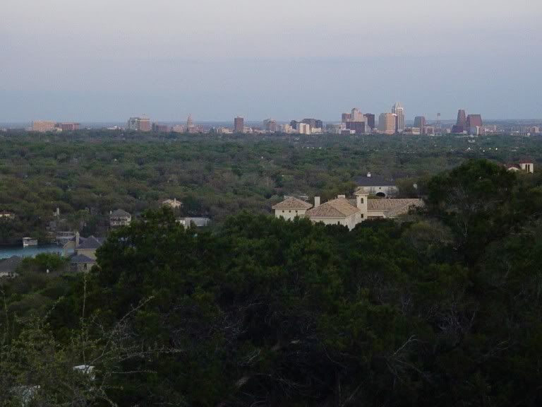
The owner of the Oasis lives in this cliffside mansion, about a quarter mile north of his restaurant.

__________________
Austin.Texas.USA
Home of the 2005 National Champion Texas Longhorns
Reply With Quote
     
     
  #14  
Old Posted Oct 25, 2007, 12:49 PM
Mopacs's Avatar
Mopacs Mopacs is offline
Austinite
 
Join Date: Jul 2002
Location: Austin.TX.USA
Posts: 4,585
Quote:
Originally Posted by arbeiter View Post
It is nice but kind of misleading. It's largely ashe juniper which barely grows taller than 15 feet, it's a very scrubby tree. It's kind of like a Texas version of chaparral - actual woodland areas are usually only found next to the water.
Speaking of ashe juniper/cedar trees, such vegetation is thought to be explosively flammable in nature. One longtime fear is the threat of very destructive wildfires in the eastern Hill Country where hillside/valley developments have become plentiful. Its really not a matter of if, but when this will occur. I would hope that the ongoing Southern California wildfires will draw some attention to our local risks.
__________________
Austin.Texas.USA
Home of the 2005 National Champion Texas Longhorns
Reply With Quote
     
     
  #15  
Old Posted Oct 25, 2007, 12:56 PM
LSyd's Avatar
LSyd LSyd is offline
Red October standing by
 
Join Date: Oct 2002
Location: Columbia/Sumter, SC
Posts: 16,913
sweet.

-
__________________
"The vapors! The fainting couch! Those heartless elitists are burning down the plantation with their logic and arithmetic!"

-fflint
Reply With Quote
     
     
  #16  
Old Posted Oct 25, 2007, 2:18 PM
Great_Hizzy Great_Hizzy is offline
H-town Baller
 
Join Date: Jul 2002
Posts: 1,441
Good stuff!
__________________
Disciple of the written word. Antagonist of the uninitiated.
Reply With Quote
     
     
  #17  
Old Posted Oct 25, 2007, 2:26 PM
crisp444 crisp444 is offline
Registered User
 
Join Date: Apr 2006
Posts: 920
Wow, Austin has got to be the prettiest part of Texas! Very nice photos.
Reply With Quote
     
     
  #18  
Old Posted Oct 25, 2007, 2:27 PM
10023's Avatar
10023 10023 is offline
Registered User
 
Join Date: Jun 2007
Location: London
Posts: 21,146
The only city in Texas that I have any real inclination to visit (and unfortunately not the one that I've been forced to travel to by work).
Reply With Quote
     
     
  #19  
Old Posted Oct 25, 2007, 4:06 PM
arbeiter's Avatar
arbeiter arbeiter is offline
passion for patterns
 
Join Date: Apr 2004
Location: San Francisco
Posts: 10,336
Kevin, where the hell is Mount Lucus? what an uninviting name. Travis Peak is interesting, it's on 1431 as you go towards Marble Falls, and there's actually a sign - for a moment, if you squint your eyes, you could be in California.

Another thing about Austin's terrain that confuses many people is that the hilliest parts are below the escarpment line, meaning you can't really see them from many parts of the city. It's more of a drop off, then a valley (where Lake Austin is), then it rises back up again.
__________________
you should know that I'm womanly wise
my website/blog. or, my flickr site.
Reply With Quote
     
     
  #20  
Old Posted Oct 25, 2007, 4:11 PM
arbeiter's Avatar
arbeiter arbeiter is offline
passion for patterns
 
Join Date: Apr 2004
Location: San Francisco
Posts: 10,336
A general rule I go by as to whether it's really a prominent point is to use the Marilyn system that England (as well as the UK and Ireland) uses, which is 250m of relative height - just under 500 feet.

http://en.wikipedia.org/wiki/Marilyn_%28hill%29
__________________
you should know that I'm womanly wise
my website/blog. or, my flickr site.
Reply With Quote
     
     
This discussion thread continues

Use the page links to the lower-right to go to the next page for additional posts
 
 
Reply

Go Back   SkyscraperPage Forum > Photography Forums > My City Photos
Forum Jump


Forum Jump


All times are GMT. The time now is 3:25 AM.

     
SkyscraperPage.com - Archive - Privacy Statement - Top

Powered by vBulletin® Version 3.8.7
Copyright ©2000 - 2024, vBulletin Solutions, Inc.