HomeDiagramsDatabaseMapsForum About
     

Go Back   SkyscraperPage Forum > Discussion Forums > City Discussions


Reply

 
Thread Tools Display Modes
     
     
  #1  
Old Posted Jul 17, 2018, 7:16 PM
Denvergotback Denvergotback is offline
Registered User
 
Join Date: Nov 2017
Location: Provo
Posts: 195
Keeping cities "afloat"

This is actually a topic I have always found extremely fascinating. Basically the topic is: What problems does your city (or any city) have, and how have they been able to overcome it? I prefer problems and solutions that are unique and not something that every city has to overcome. It could be a problem that the city has been fighting/dealing with for centuries, or a new problem that has just recently been arising.

Some examples are: the high water table in parts of Texas. Dallas for example, you can forget watering your grass, you need to water your foundation instead, negligence to do so may result in a dry ground that tends to shift and can shift your house in opposite directions. Foundations breaking around Dallas are extremely common and can easily be cured by watering your house.

In the early days of Chicago and New York, building high rises had their own challenges, they needed heating coils and fans networking the building to keep their facades and structures safe from the extreme temperatures.

For more extreme examples, Paris, an amazing and beautiful city, has to deal with Catacombs. They are fascinating to read about and they have some incredible history and insight. But there is a dark side to them. Over the years as Paris has continued to grow, the Catacombs have made building tall buildings in Paris a nightmare, as making one structure too heavy has been known to cause a collapse in the ground. Even in areas without a large or heavy structure on it, there has been many reporting's of the ground collapsing in on itself as a result of these tunnels.

Another extreme one that is interesting to learn about is Tokyo. Tokyo is located among one of the most unfortunate locations on the planet, in terms of natural disasters. They have a very active and very large volcano- Mt Fuji. They have Earth quakes and many nuclear power plants nearby. They have ran out of so much land that they are literally having to build up new land on the ocean to continue building the city, and I have heard of times when tsunamis have come and swept/threatened these new parts of the city. And on top of all of that, Tokyo also gets tropical storms and typhoons.... So how does a city like that overcome so much of this?

I would also like to hear what solutions some cities have come up with that have failed as well. For example, Venice has been slowly sinking for a while now. They have been also dealing with the problems of rising tides. One solution they came up with (a few decades ago) for the rising tides is to put pumps underground and to constantly pump the water away. Well one solution led to another problem, turns out they were pumping all the ground water out as well and have caused the city to sink at a much faster pace. To this day they are still dealing with a sinking city, rising tides, and a new problem that arose from pumping ground water- they now have an uneven city. To this day Venice is tilting slightly to the east, something scientist have never noticed before. https://www.livescience.com/19195-ve...ng-slowly.html

Another can be the city of New Orleans, having the pleasure to be located below sea level is no easy task. As we all know the consequences from time to time. The city has built many levees and pumps to keep New Orleans dry, but somehow that is still leaving the locals worried that it doesn't seem to be doing enough. https://www.nola.com/opinions/index....rotection.html

Mexico City is also an interesting one. Mexico City is a giant city floating on a lake that was formed in a crater of a large volcano. It originally became a city as it was a smart and strategic location to defend for the Aztecs. Today we see this large metropolis starting to sink in the lake chambers below, to the extent that has some wondering if a collapse all together is imminent.
As the city grows, the more people that need water. The city gets its water for its residents from the water underneath that is keeping the city afloat. Every day that the city takes water from underneath, the higher the chance the city has at collapsing on itself. There has been some tried solutions that may not be working as well as hoped, in putting giant pumps in nearby rivers to pump water back into the lake underneath the city. But such efforts have not been great.

I am very interested to hearing about many more stories like these. They have taught me how much it takes to keep a city "afloat" or functioning.
Reply With Quote
     
     
  #2  
Old Posted Jul 17, 2018, 10:11 PM
bnk bnk is offline
BANNED
 
Join Date: Mar 2006
Location: chicagoland
Posts: 12,741
"afloat"

Hell shit the entire city of Chicago was raised up out of the swamp.

With good old screw jacks you can raise the Sears Tower as high as you wanted to.


https://en.wikipedia.org/wiki/Raising_of_Chicago


During the 19th century, the elevation of the Chicago area was not much higher than the shorelines of Lake Michigan, so for many years there was little or no naturally occurring drainage from the city surface. The lack of drainage caused unpleasant living conditions, and standing water harbored pathogens that caused numerous epidemics. Epidemics including typhoid fever and dysentery blighted Chicago six years in a row culminating in the 1854 outbreak of cholera that killed six percent of the city’s population

...

In January 1858, the first masonry building in Chicago to be thus raised—a four-story, 70-foot (21 m) long, 750-ton brick structure situated at the north-east corner of Randolph Street and Dearborn Street—was lifted on two hundred jackscrews to its new grade, which was 6 feet 2 inches (1.88 m) higher than the old one, “without the slightest injury to the building.” It was the first of more than fifty comparably large masonry buildings to be raised that year. ... Before the year was out, they were lifting brick buildings more than 100 feet (30 m) long, and the following spring they took the contract to raise a brick block more than twice that length


By 1860, confidence was sufficiently high that a consortium of no fewer than six engineers—including Brown, Hollingsworth and George Pullman—took on one of the most impressive locations in the city and hoisted it up complete and in one go. They lifted half a city block on Lake Street, between Clark Street and LaSalle Street; a solid masonry row of shops, offices, printeries, etc., 320 feet (98 m) long, comprising brick and stone buildings, some four stories high, some five, having a footprint taking up almost one acre (4,000 m2) of space, and an estimated all in weight including hanging sidewalks of thirty five thousand tons. Businesses operating out of these premises were not closed down for the lifting; as the buildings were being raised, people came, went, shopped and worked in them as if nothing out of the ordinary were happening. In five days the entire assembly was elevated 4 feet 8 inches (1.42 m) in the air by a team consisting of six hundred men using six thousand jackscrews, ready for new foundation walls to be built underneath...


Raising a block of buildings on Lake Street

Many of central Chicago’s hurriedly-erected wooden frame buildings were now considered wholly inappropriate to the burgeoning and increasingly wealthy city. Rather than raise them several feet, proprietors often preferred to relocate these old frame buildings, replacing them with new masonry blocks built to the latest grade. Consequently, the practice of putting the old multi-story, intact and furnished wooden buildings—sometimes entire rows of them en bloc—on rollers and moving them to the outskirts of town or to the suburbs was so common as to be considered nothing more than routine traffic.


The Briggs House—a brick hotel—raised, probably in 1866.

Last edited by bnk; Jul 17, 2018 at 11:23 PM.
Reply With Quote
     
     
  #3  
Old Posted Jul 17, 2018, 10:27 PM
bnk bnk is offline
BANNED
 
Join Date: Mar 2006
Location: chicagoland
Posts: 12,741
That was actually easy compared to reversing the course of the Chicago River.


https://en.wikipedia.org/wiki/Chicago_River

The city of Chicago is allowed to remove 3200 cubic feet per second (91 m³/s) of water from the Great Lakes system; about half of this, 1 billion US gallons a day (44 m³/s), is sent down the Chicago River, while the rest is used for drinking water.

The first moveable bridge was constructed across the main stem at Dearborn Street in 1834. Today, the Chicago River has 38 movable bridges spanning it. These bridges are of several different types, including trunnion bascule, Scherzer rolling lift, swing bridges, and vertical lift bridges.


https://en.wikipedia.org/wiki/Chicag...and_Ship_Canal

Planning and construction, 1887–1922


By 1887, it was decided to reverse the flow of the Chicago River through civil engineering. Engineer Isham Randolph noted that a ridge about 12 miles from the lake shore divided the Mississippi River drainage system from the Great Lakes drainage system. This low divide had been known since pre-Columbian time by the Native Americans, who used it as the Chicago Portage to cross from the Chicago River drainage to the Des Plaines River basin drainage. The Illinois and Michigan Canal was cut across that divide in the 1840s. In an attempt to better drain sewage and pollution in the Chicago River, the flow of the river had already been reversed in 1871 when the Illinois and Michigan Canal was deepened enough to reverse the river's flow for one season. A plan soon emerged to cut through that ridge and carry waste water away from the lake, through the Des Plaines and Illinois rivers, to the Mississippi River and the Gulf of Mexico. In 1889, the Illinois General Assembly created the Sanitary District of Chicago (SDC) to carry out the plan. After four years of turmoil during construction, Isham Randolph was appointed Chief Engineer for the newly formed Sanitary District of Chicago and resolved many issues circulating around the project. While the canal was being built, permanent reversal of the Chicago River was attained in 1892, when the Army Corps of Engineers further deepened the Illinois and Michigan Canal.


The new Chicago Sanitary and Ship Canal, linking the south branch of the Chicago River to the Des Plaines River at Lockport, and in advance of an application by the Missouri Attorney General for an injunction against the opening, opened on January 2, 1900. However, it was not until January 17 that the complete flow of the water was released. Further construction from 1903 to 1907 extended the canal to Joliet, as the SDC wanted to replace the previously built Illinois and Michigan Canal with the Chicago Sanitary and Ship Canal. The rate of flow is controlled by the Lockport Powerhouse, sluice gates at Chicago Harbor and at the O'Brien Lock in the Calumet River, and also by pumps at Wilmette Harbor. Two more canals were later built to add to the system: the North Shore Channel in 1910, and the Calumet-Saganashkee Channel in 1922.

Construction of the Ship and Sanitary Canal was the largest earth-moving operation that had been undertaken in North America up to that time. It was also notable for training a generation of engineers, many of whom later worked on the Panama Canal.In 1989, the Sanitary District of Chicago was renamed the Metropolitan Water Reclamation District of Greater Chicago

...


The canal at Willow Springs, Illinois, 1904


Also due to the occasional flooding of the Des Plaines and Chicago rivers in heavy rains the Deep Tunnel work is ongoing.

Last edited by bnk; Jul 17, 2018 at 11:25 PM.
Reply With Quote
     
     
  #4  
Old Posted Jul 17, 2018, 11:01 PM
bnk bnk is offline
BANNED
 
Join Date: Mar 2006
Location: chicagoland
Posts: 12,741
Lets just say water and too much of it has been an issue for Chicagoland and still to some degree sometimes still. It is problem that the city has been fighting/dealing with for centuries. We are still working on it though.

Who can forget the Great Chicago flood of 1992? https://en.wikipedia.org/wiki/Chicago_flood


https://en.wikipedia.org/wiki/Tunnel_and_Reservoir_Plan


Tunnels and Reservoir Plan


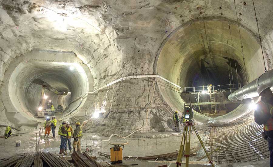
The Tunnel and Reservoir Plan (abbreviated TARP and more commonly known as the Deep Tunnel Project or the Chicago Deep Tunnel)

is a large civil engineering project that aims to reduce flooding in the metropolitan Chicago area, and to reduce the harmful effects of flushing raw sewage into Lake Michigan by diverting storm water and sewage into temporary holding reservoirs.

The megaproject is one of the largest civil engineering projects ever undertaken in terms of scope, cost and timeframe. Commissioned in the mid-1970s, the project is managed by the Metropolitan Water Reclamation District of Greater Chicago. Completion of the system is not anticipated until 2029,but substantial portions of the system have already opened and are currently operational. Across 30 years of construction, over $3 billion has been spent on the project.


Surrounding farmland also engaged in flood control projects. The Illinois Farm Drainage Act of 1879 established drainage districts. These districts were generally named for the basin they drained—for example, the Fox River Drainage District. After World War II, suburban communities began to realize the benefits of separating stormwater from sewage water and began to construct separate sewer and storm drainage lines. The primary benefit of wastestream separation is that storm water requires less treatment than sewage before being returned to the environment.

Flood damage grew markedly after 1938, when surrounding natural drainage areas were lost to development and human activity. Serious flooding has occurred in the Chicago metropolitan area in the years 1849, 1855, 1885, 1938, 1952, 1954, 1957, 1961,1973, 1979, 1986, 1987, 1996,


Status

Phase 1, the creation of 109.4 miles (176.1 km) of drainage tunnels ranging from 9 to 33 feet (2.7 to 10.1 m) in diameter, up to 350 feet (110 m) underground, was adopted in 1972, commenced in 1975, and completed and operational by 2006.

Phase 2, reservoirs primarily intended for flood control, remains underway with an expected completion date of 2029. Currently, up to 2.3 billion US gallons (8.7×10⁹ l) of sewage can be stored and held in the tunnels themselves while awaiting processing at sewage treatment plants, which release treated water into the Calumet and Des Plaines rivers.

Additional sewage is stored at the 7.9-billion-US-gallon (30×109 l) Thornton Composite Reservoir, and the 350-million-US-gallon (1,300×106 l) Gloria Alitto Majewski Reservoir near O'Hare International Airport.

The 10-billion-US-gallon (38×109 l) McCook Reservoir is scheduled for completion in 2017 (3.5 billion US gallons (13×109 l)) and 2029 (6.5 billion US gallons (25×109 l)).

Because the reservoirs are decommissioned quarries, construction has been delayed by decreased demand for the quarried gravel. Upon completion, the TARP system will have a capacity of 17.5 billion US gallons (66×109 l) of storage


On October 3, 1986, a heavy thunderstorm drenched the southern portion of the Deep Tunnel area with several inches of rain in a short period of time. While the Deep Tunnel system performed satisfactorily by absorbing excess water, water within the system itself rushed past the north side of Chicago and near the Bahá'í Temple in Wilmette.

Geysers of over 65 feet (20 m) were reported in both locations for up to an hour as the water was redistributed more evenly through the system. A 30 ft (9 m) geyser erupted downtown at the corner of Jefferson and Monroe. A system of watertight bulkheads has since been installed to prevent the event from occurring again.

During the Chicago Flood of 1992, the water from the Chicago River that leaked into the long-disused underground freight tunnel system was eventually drained into the Deep Tunnel network, which itself was still under construction.


Good photos of the reservoir in the link below.

http://interactive.wbez.org/photos/deeptunnel/


After 40 years, Chicago's Calumet Deep Tunnel project is complete

The Thornton Reservoir is the final stage of the TARP tunnel project's Calumet branch. When the former limestone quarry fills, it will add 7.9 billion more gallons of capacity to Chicago’s stormwater runoff system.


http://gapersblock.com/mechanics/201...ornton-quarry/


Last edited by bnk; Jul 17, 2018 at 11:19 PM.
Reply With Quote
     
     
  #5  
Old Posted Jul 17, 2018, 11:48 PM
mhays mhays is offline
Never Dell
 
Join Date: Jul 2001
Posts: 19,802
Seattle got rid of one entire hill and big chunks of multiple others because they were in the way over a century ago. That's unusual. We filled in multiple square miles of tideflat and lowland, which is more common.

Seattle has a high water table, generally requires the parking be below-grade, and also has strict height limits. Some projects go into the water table (at high cost) but others try to stay above it. Nearly every job tries to maximize square footage within the zoning. So projects are often exercises in fitting the most square footage inside a sandwich of constraint. We don't have little cupolas on the corners of buildings because that's wasted developable area (just build a whole level at that height). Contractors and designers spend a lot of effort helping wring out every inch through nuances of structure, shoring, and other variables.
Reply With Quote
     
     
End
 
 
Reply

Go Back   SkyscraperPage Forum > Discussion Forums > City Discussions
Forum Jump


Forum Jump


All times are GMT. The time now is 12:35 PM.

     
SkyscraperPage.com - Archive - Privacy Statement - Top

Powered by vBulletin® Version 3.8.7
Copyright ©2000 - 2024, vBulletin Solutions, Inc.