So I am going to try to make a poll just for fun. It may or may not work. If not then just say what you like. I'm not going to include a "none" option as one of these 4 will be built. Please vote, and if you would like please say what you liked best about the one you voted for.
The teams are grouped teams. All 4 groups (teams) have local firms joined with the top architectural firms in the world. This is a massive project that every major firm in the world tried to get in on, starting with 9 teams and now down to 4 and before the holidays the one winner.
Waller Creek runs from North Austin through UT and down to Lady Bird Lake. Currently under construction and new tunnel is being dug from Waterloo Park (Between Brackenridge/Erwin Center and the State Capitol) to Lady Bird Lake. The tunnel will operate as a flood tunnel during times of flooding, and during normal times it brings water from the lake to Waterloo Park to keep the creek running well. It will be finished in 2015.
Below are the 4 plans for what to do with the creek itself. I will post their descriptions along with a link to their PDF and a spoiler with large size images. Some have maps some don't. But from the descriptions if you are familiar with Austin you should have no problem with the ones w/o maps. Click on the images to see larger versions.
On the east side of Austin’s downtown a series of lively public spaces are woven together by an enchanting urban creek that links the University of Texas to the City’s central open space at Lady Bird Lake. A shady baldcypress-lined corridor marks the creek’s path through the city, and what was once a flood-prone urban drainage has been transformed into one of America’s great urban promenades. A wonderfully episodic and immersive landscape combines culture and recreation with nuanced moments of respite and access to nature.
Catalyzed by the Regeneration and Curation of Waller Creek and the City’s creative and entrepreneurial culture, the surrounding neighborhoods are flourishing. A collection of unique cultural organizations and businesses have emerged around the banks and parks of the Creek, bringing together a diverse mix of people in one of those rare urban communities that is truly a great place to live, work, and visit from afar. Activated by an eclectic mix of music, food, art, recreational and civic event programming, Waller Creek is a distinctly Austin experience.
The CMG-Public Architecture proposal for Waller Creek merges Austin’s distinctive cultural context with the experiential and ecological qualities of a Hill Country Creek and the social and economic vitality of a grand urban boulevard. Waller Creek will become the signature feature in an ensemble of interconnected and coherently organized public spaces that are legible at the scale of the city. Together, the Armature and the Score for Public Life will draw on the City’s creative and entrepreneurial culture to activate a wide variety of public spaces and catalyze economic development.
A New Paradigm – A Living Institution
The Regeneration and Curation of Waller Creek will create a new paradigm; a living cultural institution that joins capital improvements with cultural programs, public-private partnerships, district level economic development, and innovative sustainability planning. Our vision is predicated on a distinctly 21st century urbanism that is networked, participatory, and interactive, blending material culture, ecology and place making, with digital media, public art, and community building.
DESIGN FOR REGENERATION
Living Systems
Ecological systems are maximized and synthesized with public access, integration of the tunnel facilities and slope stabilization techniques. A variety of plant communities and aquatic habitat improvements are
proposed to expand opportunities for native aquatic, terrestrial and avian species. The Creek is conceived as a public garden and punctuated by a series of thematic landscapes and novel ecologies.
Episodic and Immersive
The unique qualities of the depressed creek and the surrounding urban context are translated into distinct episodes and immersive experiences that draw on our innate attraction to water, simultaneously expressing contemporary culture and providing ecological services.
Five Major Public Spaces
With the creek as a natural armature a sequence of five major public spaces activate the District. Each space has a distinctive character and mix of programs. The synergistic relationship between the creek and the broader Waller Creek District is fostered by the development of six distinct neighborhoods.
Connecting Creek and City
Connectivity is provided by a continuous Creekside Multi-use Trail and Cityside Promenades that are linked by accessible ramps and stairs at each street intersection. A series of unique markers will orient visitors from Lake to headwaters and from street to creek. We will build upon Austin’s Great Streets program, Urban Rail, and the work of trail and bicycle organizations to establish an integrated approach to mobility and improvement of the public realm.
PLANNING FOR AN URBAN DISTRICT
Waller Creek Eco-District | District level planning and infrastructureintegration are brought together with the establishment of an Eco-District that will provide both a development incentive and a method to measure sustainability at the neighborhood scale.
Connecting Downtown and East Austin at Waller Creek | The connection between Downtown and East Austin is strengthened by a series of improvements and programs that are designed to enhance existing connections, anticipate future mobility programs and foster a sense of community that bridges I-35.
Heritage | The palpable sense of history and community embodied in cultural and historic resources is prized with the preservation and rehabilitation of historic structures.
THE SCORE FOR PUBLIC LIFE
Acting at the scale of the city block while envisioning the needs of the region, our focus is to draw on the diversity of individuals and local communities in the creation of a dynamic place. Although we have just begun, our process of listening, learning, and communicating with stakeholders and potential partners has thoroughly informed our proposal.
Moving forward, we will expand this process to further refine the design and continue to build a responsive, rather than prescriptive, program. By creating opportunities for people to begin working, playing, and learning through the use of quick build prototyping and temporary uses we will reveal the most successful programs and uses.
We will work with the Conservancy to develop its program capacity, build partnerships, and establish volunteer networks to make stewardship an effective part of Waller Creek’s future success.
Public Art Program | The curatorial approach to art will include interactive, ephemeral, and permanent works, and all art at Waller Creek will be about place. Whether it’s Andy Goldsworthy’s subtle response to site, or Ai Weiwei’s response to the cultural landscape, each work will be about and for the unique culture that is Waller Creek, Austin Texas.
The Waller Creek project presents designers with an urbanist’s dream: a diverse and complex city fabric is the starting point for a process of discovering how to reach the peak of this city’s potential for fostering a high quality of life. We begin with what is given to us by Waller Creek now – all its messy and difficult constraints. Utilizing no cookie cutter ideas, we simply let the city, the citizens, and the creek itself implicitly suggest each intricate and site-specific design move while we designers listen closely.
What does the hidden, enclosed, unsafe channel of Waller Creek say it needs? What does the Brackenridge/ Waterloo Park area, with its hulking Waller Creek Tunnel infrastructure, cry out for? What does the Red River club scene ask of the new park? What would animate and make most pleasurable the Convention Center and nearby hotels? What does the beloved Lady Bird Lake wish the creek to become? What kinds of park places best meet the needs and wants of the unique people who reside in this hot, humid, funky, outdoor-living, multi-cultural, football- and party-loving town?
We believe that there are four basic answers to these questions: open up, connect, energize, and honor.
Open Up: Open up the creek to the city. Widen its path and shoreline wherever possible. Make entry easy. Create gradual slopes down to it often. Make its waters, structures, and trees a spectacle in the city and wonderful to occupy. Make the whole park a seamlessly felt, seen, and alluring central destination.
Connect: Assemble the complex mosaic of contiguous city areas from UT all the way to Lady Bird Lake and from East to West Austin, not only with the central Waller walkway and Parks but also with ten beautiful new bridges. Build up urbanity itself—the coming together of diverse and stimulating activities and people in a thick, condensed geography. Make concert-goers aware that a shady grove is just downstream; inform parents that just upstream of their child’s school is a great place to kick a soccer ball; and so on.
Energize: Use every opportunity to create larger singular landscape places, each with its distinctive, city-site-specific pleasurable activities: the five parks of Waller Creek. These areas—for activities such as concerts, public events, resting in the shade, and learning about the creek’s flora and fauna—will be places where people linger before being lured along to the next destination. Each will have its own spectacular quality — its “wow” — complementing the otherwise understated beauty of Waller Creek as we reimagine it. In each, that archetypal urban experience — people-watching — will stimulate civic participation and unity.
Honor: Honor the past of Austin, of Waller Creek, and of the many generations of engineers and builders who erected a stone wall here and an elegant bridge there. Preserve and renovate these marks of the past so that history is present, not erased and forgotten. Similarly, honor and expand the previously established social spaces along the creek, for example the concert lawn of Waterloo Park.
The design concept expands a renewed Waller Creek into a Chain of Parks embedded in five connected districts: The Lattice, The Grove, The Narrows, The Refuge, and The Confluence.
THE LATTICE
A lattice of six lightweight and easily deployable trail bridges spans the mouth of Waller Creek and forms the southernmost link of the Chain. Pedestrians traversing the Lattice are treated to views extending both across and below the network of bridges, fostering a sense of public connectivity among visitors and inviting exploration of the Creek mouth “terrarium” beneath their feet. A floating pontoon bridge connects the mouth of Waller Creek to a proposed extension of the south shore Lady Bird Lake boardwalk, opening to span the lake twice a day. Situated at the liminal space between Lake and Creek, the Lattice becomes a vital green link between downtown, East Austin, and the Hike and Bike Trail, and inspires an entirely new set of rituals for walking, running, biking, socializing and commuting.
THE GROVE
While the linearly connected pieces of the Lattice encourage movement forwards, backwards and above, the Grove offers a place for pause in the form of an open-air “room”. A new grove of live oaks fills a broad slope descending from street level to the creek. Locally quarried block is used as the formwork for the concrete walls lining the cut, offering shaded pedestrian coves. The Grove hosts a tremendous variety of community programs, both planned and spontaneous, including movie nights, open-air markets and outdoor exhibitions. The concurrent renewal of the Palm School, which will serve as the new home of the Waller Creek Conservancy, ensures that the area becomes an essential destination for East Austin’s kids and for the growing residential community downtown. A new cluster of play spaces that appeal to different age groups is added along the north side of the building, and the existing pool is renovated for use by young children. A new pavilion flanked by palm trees marks a family-friendly procession through the Grove to Waller Creek. Immediately adjacent to Palm Park, a spectacular, curving, many-branched aerial pedestrian connection links the park and trails to Lady Bird Lake. As a counterpart to the shady recesses of the oak-filled Grove, this accessible open-air bridge weaves through the Waller Creek tree canopy.
THE NARROWS
At the center of the chain lies the Narrows, an area of new development along the banks of Waller Creek, enabled by the tunnel project’s elimination of the threat of flood. Following the cues of the Boiling Pot balcony and Easy Tiger patio, creek-facing properties may make use of new opportunities for outdoor seating, retail and art spaces within the existing architecture lining the creek. The spatial configuration of the Narrows incentivizes new development while maintaining the character of the Austin patio lifestyle. The IH-35 embankment between 4th and 6th Streets will be replaced in-situ by an open viaduct, greatly improving east-west connectivity and doubling parking capacity between 6th and 8th Streets. All four lots are enclosed by a programmable LED “media mesh”, which can display festival events, announce the night’s concerts, and present time, weather, and local attractions while reinforcing vital connections between East Austin and downtown.
THE REFUGE
Presenting a unique opportunity for discovery and exploration, the Habitat Refuge - an extended 8th Street Bridge - offers a distinctive model for the way in which new urban infrastructure can sustain rather than weaken the natural environment in which it sits. The bridge pier is engineered as an “ecological machine” that treats stormwater from the roadway and adjacent development before discharging it into a wetland habitat, alluringly housed in a sculptural structure that hosts explorations of creek habitat led by local educational programs. Complementing the refuge is an island park in the creek, created by seizing the opportunity offered by the imminent relocation of the Austin Police Headquarters. A flat, commodious island created by splitting Waller Creek north of 8th Street offers year-round park activities and accommodates small planned events.
THE CONFLUENCE
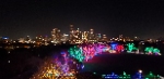
Also responding to and engaging the introduction of the Waller Creek Tunnel into the landscape, but in a wholly different way, is the final link in the chain, the Confluence. The concrete vane for the tunnel approach channel is used as a structural support for a new lawn that floats out over the water, reclaiming parkland that would be otherwise lost to the tunnel project. A rebuilt 12th Street bridge creates space for a bicycle trail and pedestrian walks embedded within a cypress wetland that includes a constructed spring out of which Waller Creek flows. Seemingly floating atop the tunnel inlet structure is the Poppy, a lightweight and luminous bandshell pavilion that creates a new icon for Austin and diversifies music programming in the park. The Poppy is itself the site of confluence: a coming together of water, landscape, music and people, staking its claim as a premier center of public life of Austin.
Connecting each link of the chain are the banks of Waller Creek itself, which have inscribed upon them the physical history of city-building in Austin. To both preserve the historical character of the creek and better sustain the regional ecologies, durable bioengineering techniques and a native plant palette are employed along the banks of the creek, which is now entirely accessible from north to south. At places where the old creek masonry walls have dignity and durability, they are conserved as embodiments of local history. Invigorating the life of the creek and anchoring it firmly in the present are artist Oscar Tuazon’s Water Wheels. Kinetic installations near the 4th and 8th Streets tunnel inlets, the wheels rotate on bearings just below the creek surface. The wheels indicate the fluctuation of water levels, translate the creek flow into animation and sound at street level, and soften the tone of the tunnel inlet structures, all the while reminding visitors of the ceaseless energy and forward movement of the creek itself.
A vibrant, green future for Austin requires that we protect and enhance the natural assets that sustain healthy urban living. Our design proposal is structured around two intertwined efforts, the transformation of Waller Creek into an OASIS in every sense of the word, and the cultivation of creekshed communities that express an authentic and symbiotic relationship with the Creek.
Our approach to creating the Oasis is to apply minimal interventions that “speed up or slow down the process of nature” to maximize ecosystem services that benefit the people of Austin. In this way we, like farmers, take on the role of time as we reshape the land, cleanse the water and harness the creekshed’s sustainable resources to grow an unforgettable Oasis experience along Waller Creek.
The transformation of Waller Creek will be a dynamic process, guided by the concepts laid out in this proposal, but flexible to respond to emergent opportunities. Our designs are built from a simple collection of practices that constitute the “farmer’s toolbox.”
• Earthwork: Terraces, Living Walls and Bioengineering
• Irrigation: Smart Stormwater, Reclaimed Waters and Water Towers
• Shade: Big Trees, Solar Canopies and Darkness
• Growth: Adaptation Palettes, Designed Experiments and Urban Agriculture
• Celebrations: Walkway, Platforms and Playscapes
This competition will yield many exciting ideas, but in the end the Conservancy and the City will have to move forward on a more modest course of action and an important question will be, ‘what should we do first?’ Our thinking is that the core creek cleanup and reforestation is the highest priority and the best use of initial funds to have the most catalytic impact toward implementing the vision. This first step will be key to changing public perception about Waller Creek. Until the public can see a vision, it will be difficult to muster political and financial support. Our proposal begins with the Cypress Walk, an unforgettable journey on an elevated walkway along the bottom of the Creek. As its first project, the Cypress Walk forms the very heart of the Oasis.
After The Cypress Walk is implemented, many open spaces and redevelopment possibilities will emerge. Our proposal includes four major park improvements starting at the north with Waterloo Park and working our way south through Music Bend, Palm Park and Lady Bird Park. These could come online independently and in any order as resources and community interest take hold. Our proposal also describes four redevelopment scenarios that could be catalyzed by investing in Waller Creek.
Waterloo Park is where the impact of the Waller Creek Tunnel is most apparent. The park is centered on the inlet structure and pool, but we will use a large new landform to tame the structure and shift the focus to an outdoor theater under the trees. A great Waterloo Park will be even better for festivals and will stimulate redevelopment
of the “Waterloo West” blocks on the other side of Trinity Street.
Music Bend becomes an extension of the Red River music scene. We propose that it be located on the public lands bound on the west by Waller Creek, north and south by 9th and 7th Streets and the east by an extended and narrowed Sabine Street. This park, dedicated to the dissemination of music knowledge and appreciation, would be most read¬ily implemented in conjunction with redevelopment of the “Music Lofts” blocks to the east once the police station and other city functions are relocated. Music Bend is also the terminus of the Sabine Market Street and is punctuated by
a water tower overlook and pavilion.
Palm Park is arguably the most critically needed open space along Waller Creek. Once a haven for East Austin fami¬lies, it was a casualty of the expansion of East Avenue into I-35. Palm Park should be a public water playscape, which will make it an attractive destination for families. Palm Park is the southern terminus of the Sabine Market Street and is punctuated by a water tower overlook integrated into the Hydro Center, a proposed adaptive reuse of the Palm School as an outdoor education basecamp. Redevelopment of the hotel site and lands to the north of the park will create active edges for the park and residents of the near East Side. The new “Zona Saltillo” development would be particularly well situated to enjoy this new swimming hole.
Lady Bird Park at the confluence of Waller Creek and Lady Bird Lake. Here, the Waller Creek Tunnel again has a significant impact. We will reorient attention on the delta where the landscape opens up, to allow a diversity of immer¬sive experiences, from bird watching and nature walks to urban farming and large family gatherings. As Lady Bird Park comes to life, a new mixed-use neighborhood, “Chavez South,” building on the diversity of the Rainey Street district, could grow along Cesar Chavez Street.
Walking along Waller Creek for the first time, we were struck by its raw beauty, the quality of light reflected on the limestone walls, the peaceful isolation that winds its way from Waterloo Park to Lady Bird Lake. We noticed its inhabitants a few turtles, a few birds, a few bats, a few fish and the homeless. We relished the shaded walks and the old bridges, the nooks and the crannies, the steep banks. We enjoyed the overflowing planting that attracted monarchs and bees, the gurgling sound of water over its karst bed. Our design proposal celebrates that environment, amplifies its beauty and engages the nature of Waller Creek with its urban nature. We propose to KEEP WALLER WILD, a carved haven of healthy wilderness where people and wildlife mingle, a mysterious journey through a romantic landscape in the heart of the growing Capital of Texas, an invitation to all Austinites to recreate, celebrate and preserve this incredible resource.
The mile-long WallerWalk winds its way up the Creek through the Delta’s islands and the Lower Wild, skims the shores of Palm Park, surfaces at the Urban Canyon, descends back to the Creek in the Upper Wild, ending on the great lawn on Waterloo Park. The majestic figures of more than 300 bald cypress mark the length of the creek. Lit at night, they discretely give Waller Creek a distinctive presence in the city and a safe experience to enjoy the Creek at all hours. New bridges connect the city to the Walk and the Creek, expanded sidewalks at existing bridges become overlooks onto the creek, and GetDowns an opportunity for creek direct access. On the creek banks and in the park’s wetlands, all species of native plants grow and attract wildlife. In the Urban Canyon, new high rises come down to the water. Public uses occupy their lower levels overlooking the Creek. Children crowd Palm Park’s expanded 6.5 acres while the old Palm School is transformed into Waller Creek Central and a host for community activities. Waterloo Park focuses on events with a new stage and cafe building. Redevelopment in East Austin catalyzes a connection to the Creek’s Urban Canyon with pedestrian amenities under the highway. Continuous bike routes along the Creek and through the city connect east to west to north to south in leisurely or zippy rides. Bioswales separating bikes from traffic on city streets cascade from the East side to the Creek. Paired with more than 10,000 new street trees, these bioswales are essential to the Creek’s long term ecological health.
These design interventions are the physical expressions of a larger vision which is rooted in our observations and understanding of Austin’s urban landscape. We see the watershed as the project’s boundary. This essential planning principle in our design is set to keep Waller Creek healthy over the long term and a significant and visible asset for the city at large. The design celebrates the importance and value of water in Austin through a Sister System - a network of bioswales and other stormwater treatment techniques embedded as landscape amenities throughout the watershed beginning in East Austin and to the west of the Creek.
Waller Creek is Austin’s missing street and our design considers the Creek as Street. This second principle ensures that planning and design, from ordinances to details, weave the creek more completely into the urban fabric of downtown Austin and respond to a fine-grained and unique urbanity that exists nowhere else.
Clarifying the creek is our third principle and keeping Waller wild depends on it. The design organizes the mile and a half long corridor creek in three distinct reaches. The Lower Wild, the Urban Canyon, and the Upper Wild form a sustainable district where ecology, equity and economy balance in distinct ways. From Lady Bird Lake to Palm Park, the Lower Wild conveys the poetic and recreational experience of being immersed in nature; the Urban Canyon, from Palm Park to 7th Street, is where creek meets city with the most contrast in a lively and densely-developed condition, and the Upper Wild, from 7th to Waterloo, blends the wild creek with the civic qualities of urban parklands.
This proposal believes in Austin and Waller Creek; it is not an overhaul but careful crafting of design and planning moves that will build upon the richness that is there and enhance the whole.
Like the first and third. Whichever one interacts with the urban space of downtown is the one I want. It's hard to tell though from the info we have here which one that is. The fourth proposal is horrific.
The first one is my favorite by far. I originally liked the second one but after getting a better look the first one seems to be the most ambitious and something Austin does not have. The Lake Flato design as I stated before is basically a glorified version of the hike and bike trail. Remember this is an urban creek that is already in an urban setting. Lets make the most out of that and create a truly international destination.
__________________
"GOOD TIMES!!!" Jerri Blank (Strangers With Candy)
I told you Jdawg, but now I'm starting to change my mind and like the second one better. Overall the first one is better imo but its so hard to pass up on a pedestrian bridge. East of 35 is going to hopping more and more with pedestrian traffic and it would be great to have another viable option to cross the river rather than have to go all the way down to pleasant valley.


 Linear Mode
