| |
 Posted May 3, 2024, 1:08 PM
|
 |
The Vomit Bag.
|
|
Join Date: Oct 2003
Location: Otisburgh
Posts: 44,981
|
|
Quote:
Originally Posted by Crawford

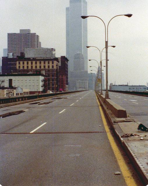
Yes. The West Side Highway was closed for a period in the 1970's, before it was demolished. Those pictures are undoubtedly from that era.
The second pic also shows Tom & Giselle's former abode, though the building has been radically reconstructed and is almost unrecognizable.
|
Indeed.
Quote:
|
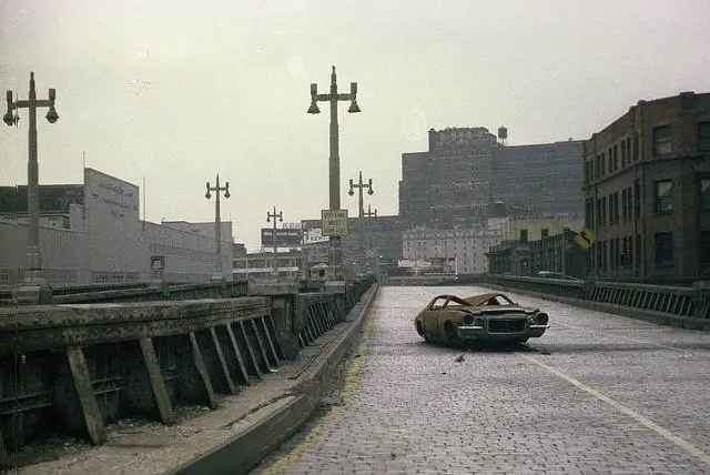
Built between 1929 and 1951, the highway had narrow confines—which could not accommodate trucks—and sharp S exit ramps that made it obsolete almost immediately. Maintenance was minimal, and the use of corrosive salts to de-ice the highway in winter accelerated its decay. When chunks of its facade began to fall off due to lack of maintenance, and a truck and car fell through it at 14th Street in 1973, the highway was shut down, and a debate began over whether to renovate it or dismantle it. Attitudes to urban planning had changed in the intervening decades, and the decision was made not to repair the decaying structure.
|


Collapsed section at 14th Street

May 1973, seven months before collapse:

Quote:
1973 collapse
On December 15, 1973, an 80-foot-long (24 m) section of the northbound lanes between Little West 12th Street and Gansevoort Street collapsed under the weight of a dump truck, which was thought to carry over 10 short tons (9,100 kg; 8.9 long tons) of asphalt for ongoing repairs of the highway. The joints between transverse stringers holding up this section of roadway and the eastern main girder (holding the decorative friezes), failed. A four-door sedan followed the truck through the hole; neither driver was seriously injured. It took hours to back all the traffic off the span trapped behind the collapse. It was later learned that the truck was actually carrying 30 short tons (27,000 kg; 27 long tons) of asphalt, and was 9 short tons (8,200 kg; 8.0 long tons) overloaded. Blame was assigned to the trucking company, Edenwald Construction Corp. of Whitestone, Queens, but they were still awarded a no-bid contract to clean up the mess.The day after, both directions were closed indefinitely south of 18th Street. This not only closed off the oldest section (between Canal Street and 18th Street), but also the newest sections (south of Canal Street), because ramps south of the collapse only permitted northbound entrances and southbound exits. The southernmost northbound exit was at 23rd Street.
The highway was indefinitely closed south of 18th Street. The northbound lanes were also closed from 18th to 48th Street, while southbound traffic between 42nd Street and 18th Street was reduced to one lane. Eventually inspections revealed that the highway south of 46th Street was not structurally sound, and had to be closed to vehicular traffic. The ramps to/from 46th Street were configured as the temporary southern terminal for northbound traffic on the highway, and the ramps to/from 57th Street were configured as the temporary southern terminal for southbound traffic. The segment north of 57th Street carried traffic over the Penn Central Rail yards, and could not be closed as there were no surface streets on which to reroute traffic. This section of Miller Highway remained in use into the 1980s, and has been since rebuilt.
Rehabilitation proposals
After the cleanup of the collapsed section at Gansevoort Street, the highway remained standing but closed to traffic while its fate was decided. The City performed a preliminary survey of the highway after the collapse, and confirmed extreme structural deterioration of connections between the longitudinal girders and transverse floor beams. The City had not inspected this structure since its opening, and hired Hardesty and Hanover, Consulting Engineers, to perform a full inspection of the roadway in 1974. A four-volume report was delivered to the City, stating that:
Public officials anticipated its early demise as far back as the mid-1950s. The use of salts to melt ice and snow, combined with heavy traffic and poor drainage, corroded and eroded the deck, of which portions had fallen down into West Street before the major December 1973 collapse. The structure south of 46th Street should be closed to vehicular traffic until a decision is made to demolish or repair / rehabilitate the structure.
Restoration of the structure was feasible, but cost-prohibitive. The Chief Engineer of the New York Highway Department estimated a $58 million cost to partially rehabilitate the structure. Hardesty and Hanover estimated it would cost $66 million (1976 dollars) for a new road deck, median, lighting, painting, and steel repairs. A New York City Highway Department representative estimated that a complete rehabilitation, including modernization, was estimated to cost $88 million. The last option was Westway.
The City chose not to pursue rehabilitation of the existing structure because of its level of deterioration. Officials considered five options, including building a six-lane interstate highway, as well as constructing a surface highway that would cost only 20 to 25 percent as much.In March 1975, officials announced an agreement to build an interstate highway between the Battery Tunnel and the Lincoln Tunnel, taking advantage of funding and financing from the Federal Highway Trust Fund. Although ninety percent of the interstate highway's cost would have been eligible for federal funding, there was still disagreement over the proposal.
Demolition
The City elected to leave the structure standing, as there was no money available to demolish the structure. Portions were demolished when they became a threat to people or property at ground level or non-city money became available. Federal Westway money was used for the demolition of the elevated structure from 42nd Street south to the Battery and to pave surface streets as a temporary roadway while the battle over Westway continued.The portion of the highway adjacent to the collapse (Jane Street north to 26th Street) came down first, in 1977, and the portion between 26th and 42nd Streets was demolished between November 1981 and the summer of 1982. The highway from Jane Street south to Spring Street was torn down between the spring and fall of 1981, and the highway from Spring Street south to the Battery was torn down between the summer of 1981 and the spring of 1982.
The segment from 43rd to 59th Streets was left standing, since it was thought that it could be refurbished and integrated into an extension of Westway. The remaining highway would be funded separately, as interstate funds could not be used to connect an interstate highway to a limited-use facility (in this case, the Henry Hudson Parkway). Ramp and lane improvements were made in 1981, permanently closing the highway south of 59th Street. Previously, northbound traffic could enter the highway at 43rd Street and southbound traffic was directed off the highway at 59th Street. The city demolished the 43rd-59th Street portion by October 1989. Rehabilitation of the elevated structure between 59th Street and 72nd Street was completed in 1995. The only remaining section of the Miller Highway, with lampposts, is an abandoned southbound exit-ramp stub just north of 72nd Street.
|
https://en.wikipedia.org/wiki/West_S...evated_Highway
__________________
The whole problem with the world is that fools and fanatics are always so certain of themselves, and wiser people so full of doubts. (Bertrand Russell)
|
|
|


 Prev
Prev


 Linear Mode
