HomeDiagramsDatabaseMapsForum About
     

Go Back   SkyscraperPage Forum > Regional Sections > Canada


Reply

 
Thread Tools Display Modes
     
     
  #1301  
Old Posted Jul 31, 2016, 2:26 AM
kwoldtimer kwoldtimer is offline
Registered User
 
Join Date: Jan 2008
Location: La vraie capitale
Posts: 23,550
Quote:
Originally Posted by jeremy_haak View Post

Columbia Forest, Waterloo, ON (My own image)
Gentle is the heart of Central SWO.
Reply With Quote
     
     
  #1302  
Old Posted Jul 31, 2016, 4:14 AM
Chadillaccc's Avatar
Chadillaccc Chadillaccc is offline
ARTchitecture
 
Join Date: Feb 2011
Location: Cala Ghearraidh
Posts: 22,842


__________________
Strong & Free

Mohkínstsis — 1.6 million people at the Foothills of the Rocky Mountains, 400 high-rises, a 300-metre SE to NW climb, over 1000 kilometres of pathways, with 20% of the urban area as parkland.
Reply With Quote
     
     
  #1303  
Old Posted Aug 2, 2016, 3:46 AM
MonctonRad's Avatar
MonctonRad MonctonRad is offline
Wildcats Rule!!
 
Join Date: Jun 2008
Location: Moncton NB
Posts: 34,517
New Brunswick Day today, so a public holiday for me.

My middle son and myself did a day trip down to Campobello Island. It's about a three hour sojourn from Moncton, give or take as there are two ferry trips along the way, from l'Etete on the NB mainland to Deer Island, and then from Deer Island to Campobello. The ferry to Deer Island is considered part of the NB highway system and is therefore free. Curiously, the ferry to Campobello is not, and it costs a hefty $24 one way to make the crossing. The ferry is a great way to spot dolphins and whales. No whales on this trip, but we spotted a couple of pods of dolphins.


Here's my car on the Campobello ferry. You can see Eastport, Maine in the background. Campobello of course is close to the US mainland and is essentially a Canadian exclave. You can get to Campobello via an international bridge from Lubec, Maine, but for Canadians to get to Campobello this way requires a one hour drive through Maine. We took our passports with us, and drove back to Saint Stephen NB that way.


This is the Head Harbour Lightstation on Campobello. It's one of the three iconic lighthouses in NB (Cape Enrage and Miscou Island being the other two). The last time I was here there was dense fog. Luckily this time the sky was clear. There are walking trails in the general area, and it is possible to walk to the light station at low tide.


Of course, Campobello is best known as the summer home of Franklin Delano Roosevelt. He used to summer here every year up until 1921, when he contracted polio. He in fact contracted polio while at the cottage. His son, Franklin Delano Roosevelt Jr was born here. While he returned to Campobello several times as president, his duties prevented him from any long term stays. Nowadays, the Rooosevelt cottage could have been considered the "summer White House", but that distinction did not exist back then. The grounds are now an international peace park, entirely on Canadian soil, but jointly managed by Parks Canada and the US Department of the Interior. The guides wear special uniforms, which are very American in style, right down to the rangers hats.

Campobello Island now has a year round population of less than a thousand, but this might roughly double during the summertime. The island remains a popular tourist destination and has a number of amenities including several hotels, a provincial park and a golf course.

Campobello may be Canadian, but in many ways, both culturally and geographically, it feels very American. I love the island. It just seems exotic and different.
__________________
Go 'Cats Go
Reply With Quote
     
     
  #1304  
Old Posted Aug 6, 2016, 3:42 PM
MonctonRad's Avatar
MonctonRad MonctonRad is offline
Wildcats Rule!!
 
Join Date: Jun 2008
Location: Moncton NB
Posts: 34,517


Edit to the above post. There is in fact a fourth iconic NB lighthouse (there are dozens of lighthouses in NB, but these four are the ones that people think about here in NB). I forget Cape Jourimain.


The Cape Jourimain lighthouse lies near the foot of the Confederation Bridge, on Jourimain Island at the southeastern tip of NB. It is one of the older lighthouses in the province (over 150 years old) and has a long history of guiding ice boat and ferry traffic to and from PEI. It is one of two lighthouses in the province on the national register of historic lighthouses.

Over the years it has been moved three times (most recently this week) because of a total of over 200M of coastal erosion during the last century and a half. Sadly it has fallen into disrepair (as you can see from the photo), but the property is now owned by the nearby Cape Jourimain Nature Centre, and plans are afoot to reinstall the light in the tower and renovate it as a wildlife viewing platform. The future is starting to look bright for this old lady.
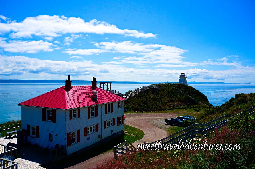


The Cape Enrage lighthouse is also in the southeast of the province, but is on the shores of Chignecto Bay rather than the Northumberland Strait. This light station is also located on a coastal island (Barn Marsh Island) but like the Cape Jourimain Light, is easily accessible by a causeway from the mainland.

Cape Enrage is the oldest light station on the NB "mainland", built in 1838. Like with many lighthouses, it's future was in serious doubt, but about two decades ago, a high school teacher from Riverview NB led an effort to transform the property into a tourism destination. This has been spectacularly successful with the keeper's house now a tea room and with on site tourism attractions such as rock climbing, rappelling, a zip line and a staircase down the cliff to the beach where fossils can be found. Conde Nast Traveller and Frommers have both declared that Cape Enrage affords one of the most spectacular views in Canada.
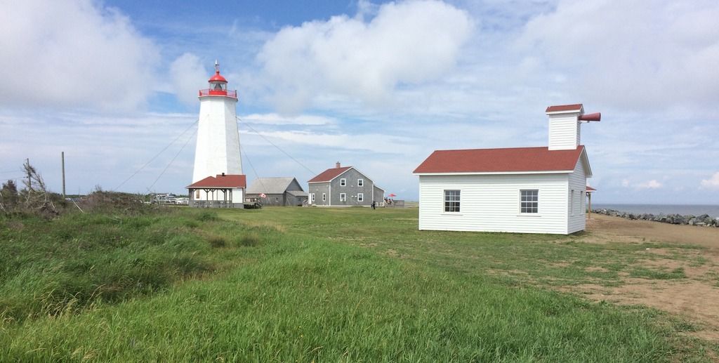


This is the Miscou Island lighthouse, located on Miscou Island at the extreme northeastern tip of NB. This lighthouse was built in 1856 and is the other lighthouse in the province on the national register of historic light stations. This lighthouse is impressively large and well maintained. It is a tourist attraction in it's own right, with a restaurant on site as well as a gift shop and walking trails and a beach. The drive through the Acadian Peninsula to get to the lighthouse is quite scenic. I took this photo several weeks ago.

In order to get to Miscou Island, you have to use the Miscou Island Bridge.


This is an impressively large bridge especially given the fact that the year round population of Miscou Island is only 585. This is a good example of your NB tax dollars at work for you!


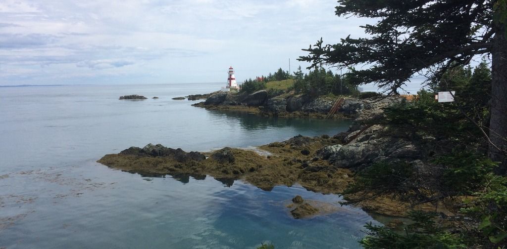
To complete this tour of iconic NB lighthouses, I'll repost the photo of Head Harbour Light on Campobello that I took last week. In many ways this is the most remote of these iconic beacons as in order to get here, you either have to take two ferries or drive for an hour through the USA in order to re-enter Canada at Campobello Island.

Head Harbour Light is the oldest lighthouse in NB, built in 1829. It's location is truly striking and the remoteness of the light compelling. The image below shows the rocky islet the light is built on. It is accessible at low tide, but you had better watch out or else you will get stranded for six hours until the next tidal cycle......

__________________
Go 'Cats Go
Reply With Quote
     
     
  #1305  
Old Posted Aug 6, 2016, 4:25 PM
SignalHillHiker's Avatar
SignalHillHiker SignalHillHiker is online now
I ♣ Baby Seals
 
Join Date: Jul 2012
Location: Sin Jaaawnz, Newf'nland
Posts: 34,693
Gorgeous AB/NB pics.

That lighthouse is very picturesque - gorgeous location!

*****

A few of the Clarenville region. It reminds me a lot of British Columbia in that there are only glimpses out to open sea, with land all around.

Clarenville and Area by R C, on Flickr

Clarenville and Area by R C, on Flickr

Clarenville and Area by R C, on Flickr

Trinity.

Trinity by R C, on Flickr

Trinity by R C, on Flickr

Trinity by R C, on Flickr

Elliston-Mayberly.

Elliston by R C, on Flickr

Elliston by R C, on Flickr

Elliston by R C, on Flickr

Elliston by R C, on Flickr

Bonavista

Bonavista by R C, on Flickr

Bonavista by R C, on Flickr
__________________
Note to self: "The plural of anecdote is not evidence."
Reply With Quote
     
     
  #1306  
Old Posted Aug 16, 2016, 9:51 AM
vanman's Avatar
vanman vanman is offline
Registered User
 
Join Date: Sep 2006
Location: Vancouver BC
Posts: 6,347
I took these pics last weekend at Brew Lake which is a sketchy hike just outside of Whistler.


Last edited by vanman; Aug 16, 2016 at 10:05 AM.
Reply With Quote
     
     
  #1307  
Old Posted Aug 29, 2016, 12:23 AM
Metro-One's Avatar
Metro-One Metro-One is online now
Registered User
 
Join Date: Sep 2008
Location: Japan
Posts: 16,828
Brew Lake looks like a nice place to hike too.

Also I really like the lighthouse pics on this page, the Miscou Island Bridge looks like fun to drive over.

So, during my 3 week return to Canada this year I got a chance to drive through Alberta (my first time in years). So here are a few pics I took from around the Pincher Creek area and along the #3 entering the Rockies.

Prairie Poles by Ian, on Flickr

This one is probably my favourite.

Pincher Creek Dream by Ian, on Flickr

Many wind farms in the area

Prairie Wind Power by Ian, on Flickr

Morning time on the highway

Rocky Mountain Morning by Ian, on Flickr

Along the #3

Through the Rockies by Ian, on Flickr

Lussier Hotsprings in BC

Lussier Hotsprings by Ian, on Flickr

Along the Rocky Mountain Trench, heading north

Bridge and Wall by Ian, on Flickr

And a classic mountain shot, why not.

Rocky Mountains by Ian, on Flickr
__________________
Bridging the Gap
Check out my Flickr: https://www.flickr.com/photos/306346...h/29495547810/ and Youtube channel https://www.youtube.com/channel/UCV0...lhxXFxuAey_q6Q
Reply With Quote
     
     
  #1308  
Old Posted Aug 30, 2016, 1:46 AM
itom 987's Avatar
itom 987 itom 987 is offline
Moderator
 
Join Date: Aug 2003
Location: Edmonton
Posts: 5,046
Alberta, BC, Yukon, and North West Territories have hot springs. I wish the rest of the country had them.
Reply With Quote
     
     
  #1309  
Old Posted Aug 30, 2016, 2:07 AM
Klazu's Avatar
Klazu Klazu is offline
Registered User
 
Join Date: Apr 2012
Location: Above Metro Vancouver clouds
Posts: 10,186
Brew Lake, never heard of that one. How come it was sketchy?
Reply With Quote
     
     
  #1310  
Old Posted Aug 30, 2016, 3:33 AM
Dwils01's Avatar
Dwils01 Dwils01 is offline
Urban Fanactic
 
Join Date: Mar 2010
Location: Coquitlam
Posts: 3,246
Just looking at all these pictures, It's going to be interesting to see them in person when I drive from the Sault to Surrey in October.
Reply With Quote
     
     
  #1311  
Old Posted Aug 30, 2016, 2:57 PM
SHOFEAR's Avatar
SHOFEAR SHOFEAR is offline
DRINK
 
Join Date: Jun 2004
Location: City Of Champions
Posts: 8,219
Quote:
Originally Posted by SignalHillHiker View Post
Gorgeous AB/NB pics.

That lighthouse is very picturesque - gorgeous location!

*****

A few of the Clarenville region. It reminds me a lot of British Columbia in that there are only glimpses out to open sea, with land all around.
Trinity is such a beautiful town.

There is a really great hiking trail above the cliffs on the other side of the bay overlooking trinity.
__________________
Lana. Lana. Lana? LANA! Danger Zone
Reply With Quote
     
     
  #1312  
Old Posted Sep 1, 2016, 8:24 AM
vanman's Avatar
vanman vanman is offline
Registered User
 
Join Date: Sep 2006
Location: Vancouver BC
Posts: 6,347
Quote:
Originally Posted by Klazu View Post
Brew Lake, never heard of that one. How come it was sketchy?
There are a lot of very steep sections of loose rock that you have to scramble over. Also the trail isn't always well marked. It's easy to get lost if you're not paying attention.
Reply With Quote
     
     
  #1313  
Old Posted Sep 3, 2016, 1:19 PM
TownGuy's Avatar
TownGuy TownGuy is offline
Registered User
 
Join Date: May 2013
Location: Cobourg, ON
Posts: 3,064
A little rural Ontario action. Northumberland County.


Last edited by TownGuy; Oct 20, 2017 at 6:10 PM.
Reply With Quote
     
     
  #1314  
Old Posted Sep 5, 2016, 9:29 PM
SignalHillHiker's Avatar
SignalHillHiker SignalHillHiker is online now
I ♣ Baby Seals
 
Join Date: Jul 2012
Location: Sin Jaaawnz, Newf'nland
Posts: 34,693
A little hike today around Brigus Head, from Brigus South to Admiral's Cove and back.


Video Link


No idea what this plant is but it ruined us today. It stung, turned red, swelled up, everywhere it made contact with our skin. Really disappointing because the fact we've no snakes or any really dangerous wildlife of any kind is one of the joys of hiking here.


As usual - lots of berries to eat along the way. Blueberries, blackberries, raspberries, partridgeberries, and others.


Can't really tell from this pic, but that yacht was huge.


Almost back to Brigus South.


And almost home, passing through Mount Pearl...


To St. John's.

__________________
Note to self: "The plural of anecdote is not evidence."
Reply With Quote
     
     
  #1315  
Old Posted Sep 6, 2016, 2:12 AM
itom 987's Avatar
itom 987 itom 987 is offline
Moderator
 
Join Date: Aug 2003
Location: Edmonton
Posts: 5,046
It looks like you touched Poison Ivy.
Reply With Quote
     
     
  #1316  
Old Posted Sep 6, 2016, 6:32 AM
SignalHillHiker's Avatar
SignalHillHiker SignalHillHiker is online now
I ♣ Baby Seals
 
Join Date: Jul 2012
Location: Sin Jaaawnz, Newf'nland
Posts: 34,693
It might be but doesn't seem to look like it to me. We don't have poison ivy here, but there are little pockets of unusual things around the island, especially in older settled places like this one, or where the Americans had bases, so it could be. We've never seen this plant, and have hiked most areas of the island, so it's definitely isolated.

Googled stinging plants and to me it most looks like stinging nettle.
__________________
Note to self: "The plural of anecdote is not evidence."
Reply With Quote
     
     
  #1317  
Old Posted Sep 6, 2016, 11:41 AM
eemy's Avatar
eemy eemy is offline
Closed account
 
Join Date: Aug 2006
Posts: 4,456
It's definitely not poison ivy, whatever it is.
Reply With Quote
     
     
  #1318  
Old Posted Sep 6, 2016, 1:38 PM
sonysnob sonysnob is offline
Registered User
 
Join Date: Aug 2011
Posts: 1,656
Quote:
Originally Posted by TownGuy View Post
A little rural Ontario action. Northumberland County.

-sniped out photos-
I love Northumberland County. I think it might be my favourite region in Ontario. I drove back to the GTA from Bon Echo yesterday and cut through Campbellford and Northumberland on my way home. There is some very beautiful pastoral scenery through the hills through there.
Reply With Quote
     
     
  #1319  
Old Posted Sep 15, 2016, 3:53 AM
someone123's Avatar
someone123 someone123 is offline
hähnchenbrüstfiletstüc
 
Join Date: Nov 2001
Location: Vancouver
Posts: 33,694
I am not sure exactly where to put this but I thought this photo was interesting. This house is purported to be the oldest house in Nova Scotia (also the oldest outside of Quebec). It sounds like it was semi-abandoned until it was bought in the 1980's and slowly restored. It appears in maps from 1699 as a fortified church. It's in the small village of Avondale, about 70 km northwest of Halifax.


Source


Another old house with a clearer history of construction and ownership is Cosby-de Gannes house in Annapolis Royal. The original house was built here in 1697 but it was burned down in an attack on the town in 1707 (the town was attacked many times by just about everybody) and rebuilt using the original foundation and chimneys in 1708. It's been lived in continuously since then. Nova Scotia was not ceded to Britain until 1713, so this is one of a small number of houses surviving from the Acadian period. I'm guessing it's not possible that the bricks in those exposed chimneys are actually from 1697 (partly because brick construction was generally of a lower quality back then).


Source


Fort Anne was built in 1629 and used until the the 1800's. It still has some stone structures from the 1600's but the surviving officers' quarters building is only from 1797. The Vauban earthworks are from 1703 (the period when Vauban was still alive and designing star-shaped forts in France; not sure if he had a hand in this one). There is still a masonry powder magazine from 1707 too. It was declared a national historic site in 1920; there's probably a plaque there that is itself historic.

Here's the fort and surrounding scenery circa 1930:


Source
Reply With Quote
     
     
  #1320  
Old Posted Sep 15, 2016, 5:26 AM
mcminsen's Avatar
mcminsen mcminsen is online now
Registered User
 
Join Date: Sep 2007
Location: Downtown Vancouver
Posts: 9,387
Quote:
Originally Posted by SignalHillHiker View Post
It might be but doesn't seem to look like it to me. We don't have poison ivy here, but there are little pockets of unusual things around the island, especially in older settled places like this one, or where the Americans had bases, so it could be. We've never seen this plant, and have hiked most areas of the island, so it's definitely isolated.

Googled stinging plants and to me it most looks like stinging nettle.

First thing I thought of when I saw the zigzag edges on the leaves was that it was stinging nettle. We have a version of it in the bushes here in the lower BC mainland that has much bigger leaves. You know the instant you brush up against some. It's like electricity. I first learned to avoid it in the Wreck Beach area many years ago.

Great pics!
Reply With Quote
     
     
This discussion thread continues

Use the page links to the lower-right to go to the next page for additional posts
 
 
Reply

Go Back   SkyscraperPage Forum > Regional Sections > Canada
Forum Jump


Thread Tools
Display Modes

Forum Jump


All times are GMT. The time now is 4:57 AM.

     
SkyscraperPage.com - Archive - Privacy Statement - Top

Powered by vBulletin® Version 3.8.7
Copyright ©2000 - 2024, vBulletin Solutions, Inc.