HomeDiagramsDatabaseMapsForum About
     

Go Back   SkyscraperPage Forum > Regional Sections > Canada > Alberta & British Columbia > Vancouver > Transportation & Infrastructure


Reply

 
Thread Tools Display Modes
     
     
  #1241  
Old Posted Mar 12, 2017, 12:48 AM
Xrayal's Avatar
Xrayal Xrayal is offline
Registered User
 
Join Date: Jul 2008
Location: New Westminster
Posts: 173
A while back someone raised the thought of reorganizing the bus routes in the Burnaby south slope area. Obviously the zone boundary factors into why the routes look like they do.

The area is a mix of a grid layout and a curvy street model. I have never ridden the buses in this area so at least I'm approaching it with very little biased. I acknowledge that I am missing the incites that only a local bus rider/driver would provide. Never the less, Here is my map with routes:
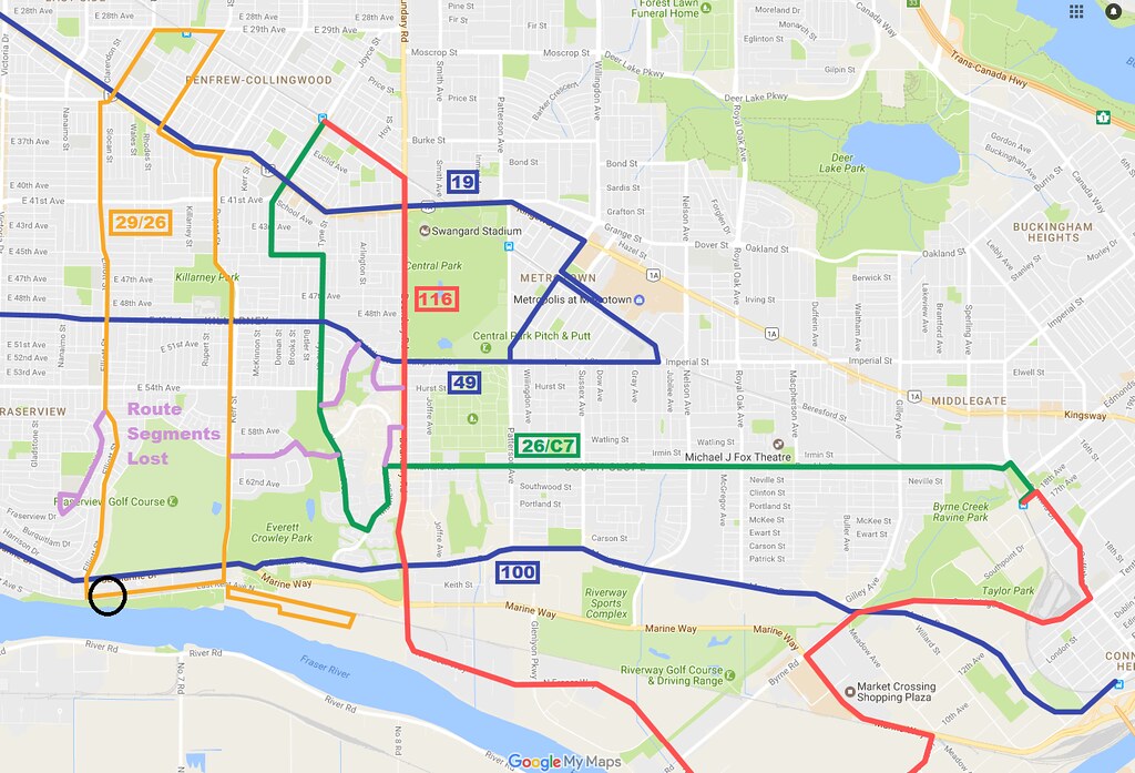
Burnaby South Slope bus routes 2 sans C5 C6 C7 by mullux

29/26:
-Would serve The River District.
-A bus bollard solution would allow passage where black circle is.
26/C7:
-The C7 is seeing better passenger numbers and a real bus could aid it to do better.
116:
Had a difficult time with how to route it. So just ran it up the simplest and direct route.

I didn't include the community shuttle routes because they would make the map harder to read. They would be sprinkled back into the slopes to provide coverage.

Any comments or feedback?
Reply With Quote
     
     
  #1242  
Old Posted Mar 12, 2017, 1:23 AM
Millennium2002 Millennium2002 is offline
Registered User
 
Join Date: Jun 2009
Posts: 1,742
From a purely commuter perspective... it doesn't look too bad? But yes the community may not like it so much for the lack of connections to some of their local destinations.

I'll post a longer response here shortly...
Reply With Quote
     
     
  #1243  
Old Posted Mar 12, 2017, 3:23 AM
Sheba Sheba is offline
Registered User
 
Join Date: Jan 2015
Location: BC
Posts: 4,305
Quote:
Originally Posted by Xrayal View Post
A while back someone raised the thought of reorganizing the bus routes in the Burnaby south slope area. Obviously the zone boundary factors into why the routes look like they do.

The area is a mix of a grid layout and a curvy street model. I have never ridden the buses in this area so at least I'm approaching it with very little biased. I acknowledge that I am missing the incites that only a local bus rider/driver would provide. Never the less, Here is my map with routes:
It looks good on paper but it wouldn't work very well in practice. Housing is not evenly placed, so routes have to be where the people are. For example the 116 on Boundary - it makes more sense to have the southern part on Joffre and then move it to Boundary.
Reply With Quote
     
     
  #1244  
Old Posted Mar 12, 2017, 5:12 AM
jbrizzy jbrizzy is offline
Registered User
 
Join Date: May 2011
Location: Vancouver
Posts: 129
Quote:
Originally Posted by Xrayal View Post
29/26:
-Would serve The River District.
-A bus bollard solution would allow passage where black circle is.
What's a bus bollard and how would that work?
Regardless I don't think Kent is wide enough for bus traffic.

I've been working on an updated version of my bus map, and I have the 29 following an old trial route from ~15 years ago. Instead of running down Elliott, it would run down Fraserview (which is wider) to Victoria, and then along Marine to River District. This would also allow the 26 routing to stay as is.

I'd upload the graphic but I can't seem to log in to my photobucket..
Reply With Quote
     
     
  #1245  
Old Posted Mar 12, 2017, 5:50 AM
Xrayal's Avatar
Xrayal Xrayal is offline
Registered User
 
Join Date: Jul 2008
Location: New Westminster
Posts: 173
Quote:
Originally Posted by jbrizzy View Post
What's a bus bollard and how would that work?
They are something Translink should begin using. They seem quite effective.

Video Link
Reply With Quote
     
     
  #1246  
Old Posted Mar 12, 2017, 7:37 AM
Sheba Sheba is offline
Registered User
 
Join Date: Jan 2015
Location: BC
Posts: 4,305
Quote:
Originally Posted by jbrizzy View Post
What's a bus bollard and how would that work?
Regardless I don't think Kent is wide enough for bus traffic.
Not only is Kent not very wide but there's very little in the way of sidewalks, which is something TransLink likes to see on bus routes.


Quote:
Originally Posted by Xrayal View Post
They are something Translink should begin using. They seem quite effective.
They look to be very effective at catching cars - I foresee a huge outcry if they're installed here.
Reply With Quote
     
     
  #1247  
Old Posted Mar 12, 2017, 10:11 AM
VancouverOfTheFuture's Avatar
VancouverOfTheFuture VancouverOfTheFuture is offline
Registered User
 
Join Date: Apr 2014
Posts: 3,274
those bus bollards should have been used on Robson to allow buses to still go past the art gallery, like originally envisioned in the 1970s by Erickson.
Reply With Quote
     
     
  #1248  
Old Posted Mar 12, 2017, 8:26 PM
deasine deasine is offline
Vancouver Moderator
 
Join Date: Mar 2007
Posts: 5,747
Buses may have difficulty navigating the slopes along Elliott from Marine to Kent: It is extremely steep.
Reply With Quote
     
     
  #1249  
Old Posted Mar 12, 2017, 9:39 PM
Kisai Kisai is offline
Registered User
 
Join Date: Jun 2014
Location: Burnaby
Posts: 1,133
Quote:
Originally Posted by Xrayal View Post
A while back someone raised the thought of reorganizing the bus routes in the Burnaby south slope area. Obviously the zone boundary factors into why the routes look like they do.

...

Any comments or feedback?
The South Slope has a super-steep grade, that is the logical reason why you don't see any direct North/South routes between Metropolis at Metrotown (which is at the top of the hill) and the surrounding areas. Royal Oak and the surrounding streets are difficult to walk up south of Rumble Street. The grade is apparently up to 25%. The only way you're going to see any connection from Metrotown to Big Bend would be via a gondola system, and even then that's probably not going to be of any use since Big Bend is where all the industrialareas are and people need their trucks to pick up things down there.

Quote:
Originally Posted by Xrayal View Post
They are something Translink should begin using. They seem quite effective.

Video Link
Ugh, these are the kinds of things you want for rail grade crossings and first-responders to prevent vehicles from getting too close to the rail in the first place. They're not really effective for other purposes than parking garages, as the video shows, people will tailgate behind buses, thus ensuring delays for the next bus.

That said, that would be far more effective for say the Arbutus corridor.
Reply With Quote
     
     
  #1250  
Old Posted Mar 13, 2017, 5:29 AM
Sheba Sheba is offline
Registered User
 
Join Date: Jan 2015
Location: BC
Posts: 4,305
Quote:
Originally Posted by Kisai View Post
The South Slope has a super-steep grade, that is the logical reason why you don't see any direct North/South routes between Metropolis at Metrotown (which is at the top of the hill) and the surrounding areas. Royal Oak and the surrounding streets are difficult to walk up south of Rumble Street. The grade is apparently up to 25%. The only way you're going to see any connection from Metrotown to Big Bend would be via a gondola system, and even then that's probably not going to be of any use since Big Bend is where all the industrialareas are and people need their trucks to pick up things down there.
The slope is between Rumble and Marine Dr, which is why there's a lot of east - west routes in the area with limited north - south sections. Same for south Van, although there are plenty of north - south routes (that got caught in the snow... ).


Quote:
Originally Posted by Kisai View Post
Ugh, these are the kinds of things you want for rail grade crossings and first-responders to prevent vehicles from getting too close to the rail in the first place. They're not really effective for other purposes than parking garages, as the video shows, people will tailgate behind buses, thus ensuring delays for the next bus.

That said, that would be far more effective for say the Arbutus corridor.
That's a good idea - have the standard gates like there are now and add these car catching bollards. It will make people think twice about trying to sneak through when they can't see the train yet. Of course the problem is who will pay for it.
Reply With Quote
     
     
  #1251  
Old Posted Mar 14, 2017, 6:56 PM
cganuelas1995 cganuelas1995 is offline
Registered User
 
Join Date: Jan 2017
Posts: 1,276
I kinda want to see what you guys can come up with in the event that Abbotsford and Mission are incorporated into the GVRD.
Reply With Quote
     
     
  #1252  
Old Posted Mar 14, 2017, 9:56 PM
Bdawe Bdawe is offline
Registered User
 
Join Date: Aug 2015
Location: Sunrise
Posts: 535
Quote:
Originally Posted by cganuelas1995 View Post
I kinda want to see what you guys can come up with in the event that Abbotsford and Mission are incorporated into the GVRD.
When I have a moment, this makes me want to go calculate the amount of service hours that Translink taxes applied to the FVRD could pay for.
Reply With Quote
     
     
  #1253  
Old Posted Mar 15, 2017, 5:33 AM
Kisai Kisai is offline
Registered User
 
Join Date: Jun 2014
Location: Burnaby
Posts: 1,133
I'll post this here:

http://vancouversun.com/news/politic...-subway-to-ubc

Quote:
Glen Schaefer
Published on: March 14, 2017 | Last Updated: March 14, 2017 4:05 PM PDT

Harcourt and Robertson, Two Mayors on Vancouver Past, Present and Future

Thursday, 5:30 p.m. to 7 p.m. | SFU Vancouver Campus, Fletcher Challenge Theatre

Tickets: Free admission

Imagine the Millennium Line running all the way to the University of B.C., alongside a limited-stop express subway connecting Coquitlam’s United Boulevard to the planned new development at Vancouver’s Jericho Lands.

Former B.C. premier and Vancouver mayor Mike Harcourt says transit authorities are thinking too small with the current plan to extend the Millennium Line underground to Arbutus Street.

“It’s crazy to end it there,” Harcourt said. “You should take it to Jericho and out to UBC.”

Harcourt, honoured last month with the Freedom of the City, is to join current Vancouver Mayor Gregor Robertson on Thursday evening for a public lecture on where the city is going.

...
If everyone remembers, Mike Harcourt was Premier when the Skytrain opened for Expo 86, and was the Mayor of Vancouver previous to that.

He's not wrong, IMO. We are thinking too small, both with transit and development in Metro Vancouver.
Reply With Quote
     
     
  #1254  
Old Posted Mar 15, 2017, 6:00 AM
Spork's Avatar
Spork Spork is offline
Shoebox Dweller
 
Join Date: Sep 2008
Location: Vancouver
Posts: 1,784
Thinking small or funding small? You can blame the Provincial and Federal governments. I am sure that Translink would love to ramp up service in a number of areas and extend further if given more funds.
Reply With Quote
     
     
  #1255  
Old Posted Mar 15, 2017, 6:40 AM
Migrant_Coconut's Avatar
Migrant_Coconut Migrant_Coconut is offline
Registered User
 
Join Date: Oct 2015
Location: Kitsilano/Fairview
Posts: 8,374
Exactly - it doesn't matter how big we think if we can't afford it. A SkyTrain all the way to UBC will be another $2+ billion AND another 10-year wait on top of the existing clustershag.
Reply With Quote
     
     
  #1256  
Old Posted Mar 15, 2017, 7:24 AM
VancouverOfTheFuture's Avatar
VancouverOfTheFuture VancouverOfTheFuture is offline
Registered User
 
Join Date: Apr 2014
Posts: 3,274
Quote:
Originally Posted by Kisai View Post
Mike Harcourt was Premier when the Skytrain opened for Expo 86
uhhh, no. he didn't become Premier until the NDP was elected in 1991.

Bill Bennet, Mini-WAC was Premier of BC. the Bennet's brought us the highways of the 50s and 60s with WAC Bennet, and the SkyTrain of the 80s with Mini-WAC. well some of that was Willy-Wooden-2-shoes. (Bill Vander Zalm) and Rita Johnston

the NDP gave us an underused line, (Millennium-Line), debts, and Fast Cats and 3 appointed Premiers.
Reply With Quote
     
     
  #1257  
Old Posted Mar 16, 2017, 5:21 AM
Kisai Kisai is offline
Registered User
 
Join Date: Jun 2014
Location: Burnaby
Posts: 1,133
Quote:
Originally Posted by VancouverOfTheFuture View Post
uhhh, no. he didn't become Premier until the NDP was elected in 1991.

Bill Bennet, Mini-WAC was Premier of BC. the Bennet's brought us the highways of the 50s and 60s with WAC Bennet, and the SkyTrain of the 80s with Mini-WAC. well some of that was Willy-Wooden-2-shoes. (Bill Vander Zalm) and Rita Johnston

the NDP gave us an underused line, (Millennium-Line), debts, and Fast Cats and 3 appointed Premiers.
You're right, I was thinking about the Mayor dates when I was talking about the Premier dates. Socred Zalm takes credit for the actual technology choice all the time.

But the Fast Cats and the Millennium Line was all Glen Clark.
Reply With Quote
     
     
  #1258  
Old Posted Mar 16, 2017, 5:33 AM
officedweller officedweller is offline
Registered User
 
Join Date: Jul 2001
Location: Vancouver
Posts: 38,309
Quote:
Originally Posted by VancouverOfTheFuture View Post
Bill Bennet, Mini-WAC was Premier of BC. the Bennet's brought us the highways of the 50s and 60s with WAC Bennet, and the SkyTrain of the 80s with Mini-WAC. well some of that was Willy-Wooden-2-shoes. (Bill Vander Zalm) and Rita Johnston
... and Grace McCarthy
Reply With Quote
     
     
  #1259  
Old Posted Mar 16, 2017, 5:32 PM
Xrayal's Avatar
Xrayal Xrayal is offline
Registered User
 
Join Date: Jul 2008
Location: New Westminster
Posts: 173
New Zone Boundarys

TransLink is currently doing a fare review. Part of the review asks about changing the way we scale for distance. I myself would prefer a more exact pricing model which I experienced while riding on San Fransisco's BART system while on vacation. However TransLink has also floated the idea of adding more zones to our current zone map and then reducing the cost increment of crossing a zone boundary. Here is my thought exercise on what that new zone map might look like.

New Zone Map 1.2 by mullux

It it just me or does Downtown/Stanley park resemble a ducks head?

Is adding more zones just making our system more cumbersome then it needs to be specially now that we have Compass that can calculate our fares for us?

Or would keeping a zone base system base model on which a complementary road pricing model could be layered on top.

We could share similar zone boundaries and acceptance might be easier given the acceptance that transit trips very on distance so maybe vehicle trips can too.

Thoughts or comments but keep it civil and fact based please.

Last edited by Xrayal; Mar 16, 2017 at 5:53 PM.
Reply With Quote
     
     
  #1260  
Old Posted Mar 16, 2017, 7:56 PM
cganuelas1995 cganuelas1995 is offline
Registered User
 
Join Date: Jan 2017
Posts: 1,276
Quote:
Originally Posted by Xrayal View Post
TransLink is currently doing a fare review. Part of the review asks about changing the way we scale for distance. I myself would prefer a more exact pricing model which I experienced while riding on San Fransisco's BART system while on vacation. However TransLink has also floated the idea of adding more zones to our current zone map and then reducing the cost increment of crossing a zone boundary. Here is my thought exercise on what that new zone map might look like.

New Zone Map 1.2 by mullux

It it just me or does Downtown/Stanley park resemble a ducks head?

Is adding more zones just making our system more cumbersome then it needs to be specially now that we have Compass that can calculate our fares for us?

Or would keeping a zone base system base model on which a complementary road pricing model could be layered on top.

We could share similar zone boundaries and acceptance might be easier given the acceptance that transit trips very on distance so maybe vehicle trips can too.

Thoughts or comments but keep it civil and fact based please.
SCREW THE ZONES! Give us distance based fares!
Reply With Quote
     
     
This discussion thread continues

Use the page links to the lower-right to go to the next page for additional posts
 
 
Reply

Go Back   SkyscraperPage Forum > Regional Sections > Canada > Alberta & British Columbia > Vancouver > Transportation & Infrastructure
Forum Jump


Forum Jump


All times are GMT. The time now is 9:49 PM.

     
SkyscraperPage.com - Archive - Privacy Statement - Top

Powered by vBulletin® Version 3.8.7
Copyright ©2000 - 2024, vBulletin Solutions, Inc.