HomeDiagramsDatabaseMapsForum About
     

Go Back   SkyscraperPage Forum > Regional Sections > United States > Southeast > Atlanta


Reply

 
Thread Tools Display Modes
     
     
  #1  
Old Posted Feb 10, 2012, 7:28 PM
testarossa50 testarossa50 is online now
Registered User
 
Join Date: Mar 2008
Posts: 761
The Atlanta History Thread

Anyone who is interested in Atlanta history, particularly history of landmarks that once were, should check out this awesome blog:

http://returntoatl.blogspot.com/

Basically a guy studies all sorts of different spots, shows what they looked like circa 1990 (when intown Atlanta was, in some ways, bottoming out before the new influx of wealth and redevelopment), and what they look like now. He also ties in historical photos and aerials.

In the blog, he links to GSU's collection of 1949 aerial photographs.

http://library.gsu.edu/aerialatlas1949/html/map.htm

I've decided to make gifs of them, to make them easy to compare with current aerials from Google Earth. Since each one takes a few minutes to make, I started out with only two areas, both of which have changed dramatically over the last 60 years: West Downtown and Buckhead.


A bunch of different things are interesting about these to me, but what continues to amaze me is how the makeshift layout of Atlanta's roads impacts the built environment today.

Also, it's simply incredible how dense and built up intown areas were in 1950, basically without a scrap of land going unused, and how completely some of those areas were razed. Below the GWCC used to sit a neighborhood with scores of houses, factories, and a railroad line--which are all but invisible today.

If anyone wants me to do the same with other neighborhoods, let me know and I'll give it a shot.


This is normally something I would have posted on city-data, but that place has become such a hotbed of racism that I decided I had to go. So I'll be posting here from now on, since this forum has a decided more progressive and forward-thinking mindset.
Reply With Quote
     
     
  #2  
Old Posted Feb 11, 2012, 5:31 AM
ATL Urbanist ATL Urbanist is offline
Registered User
 
Join Date: Dec 2011
Location: Atlanta
Posts: 4
Those GIFs are awesome -- nice work. I'm amazed to see that this area of Buckhead was so sparsely developed at that time. I had no idea. What an incredible change.

That Return to Atlanta blog is really cool.
Reply With Quote
     
     
  #3  
Old Posted Feb 13, 2012, 9:57 PM
TarHeelJ TarHeelJ is offline
Registered User
 
Join Date: Oct 2009
Posts: 1,998
Very interesting...I would love to see how Midtown has changed?
Reply With Quote
     
     
  #4  
Old Posted Feb 13, 2012, 10:38 PM
testarossa50 testarossa50 is online now
Registered User
 
Join Date: Mar 2008
Posts: 761
Quote:
Originally Posted by TarHeelJ View Post
Very interesting...I would love to see how Midtown has changed?
I hope they focus a few blog posts on Midtown. I'm sure the Biltmore will be included.

I'll try to get a before and after gif of central Midtown. One of the most striking things about it is that 10th Street didn't actually used to be contiguous--it used to disappear between Peachtree and West Peachtree: imagine how the traffic we be if that hadn't ever been connected! Also, Juniper used to dead-end at 12th Street.
Reply With Quote
     
     
  #5  
Old Posted Feb 20, 2012, 5:32 PM
waronxmas waronxmas is offline
Thought Criminal
 
Join Date: Feb 2010
Location: City of Atlanta Proper
Posts: 34
Quote:
Originally Posted by testarossa50 View Post
Anyone who is interested in Atlanta history, particularly history of landmarks that once were, should check out this awesome blog:
Great thread idea, man.

Quote:
Originally Posted by testarossa50 View Post
I've decided to make gifs of them, to make them easy to compare with current aerials from Google Earth. Since each one takes a few minutes to make, I started out with only two areas, both of which have changed dramatically over the last 60 years: West Downtown and Buckhead.

Also, it's simply incredible how dense and built up intown areas were in 1950, basically without a scrap of land going unused, and how completely some of those areas were razed. Below the GWCC used to sit a neighborhood with scores of houses, factories, and a railroad line--which are all but invisible today.
On the area West of Downtown first...

It is remarkable when you look at photographs of pre-1950s Intown Atlanta and how dense it was. Prior to the 1952 annexation it was a city of nearly half a million residents crammed into 36 square miles. This was also before the the highways sliced large sections of the city (and razed several old neighborhoods long forgotten) and was was a built environment influenced heavily by rail and mass transit.

Knowing the popular attitude of people who discuss urban environments, I'm willing to be there are a lot of people who would willing to trade a lot for us just to get back to where we were prior to the highways and "urban renewal". I have two trains of thought on that:

1. Waronxmas approves.

It cannot be discounted how badly the building of the highways affected the City of Atlanta. Had it not been for the fortitude of this city's residents to maintain their neighborhoods in the last few decades, I'm not certain Atlanta as a city would have survived. First there is the obvious fact that the highways have divided the city in to unconnected neighborhoods that cause a loss of cohesion from airs just mere blocks from each other. The other is the hope of the planners of bringing in masses of people to shop/work in Downtown didn't materialize. If anything the highways killed retail in Downtown and nearly killed it as a employment center by spurring the creation of edge cities scattered about the metro (which before the highways were mostly undeveloped forest).

On the other hand, what happened to happened to Atlanta was not unique to Atlanta. The fast adoption of highways and infrastructure geared more towards the automobile than people was an American phenomena that dominated our culture for much of the second half of the 20th century. It is still romantic to think if he had not lost as much as we did.

2.) What are you, nuts?!

While dense neighborhoods are great and all, we must remember that it is a good thing that the majority of these neighborhoods like the ones that used to exist where the Dome is now. There reason for me saying such a thing is that one thing those aerial pictures don't reveal is that those neighborhoods were slums. I'm not talking about your run of the mill "bad neighborhood" we in the 20th century view as a "slum" either. These neighborhoods were basically exactly like those found in the megacities of developing third world nations today.

Thanks to the joyus time known as Jim Crow these neighborhoods lacked running water (and toilets), paved streets, electricity, gas lines, trash removal, and were generally crappy places to live in all regards. Making matters worse, these slums were built often directly next to industrial areas and were the residents suffered all sorts of ill effects from pollution. It was conditions such as these that in fact led to the (often forgotten) Great Atlanta fire of 1917 that destroyed a sizable chunk of the old city.

I can keep going with all the ways these neighborhoods were bad but, as the saying goes, a picture(s) is worth a thousand words:


This is part of the old Vine City neighborhood that stood in your "before" picture above where the Dome is now...sometime in the early 60s!


Slums near Downtown in an neighborhood described as the "Negro Quarter" in 1936!(my guess is it is Sweet Auburn, Vine City, or near the AUC)


Buttermilk Bottom Slum in the Old Fourth Ward (which got it's name from the putrid run off a nearby dairy processing factory. yum!)

Now the question one may ask is how these neighborhoods had fared if urban renewal never came to be? Would they be trendy neighbhoods? My answer would be doubtful. The other side to this coin that I sort of mentioned before is that these slums existed not just because the residents were lower income factory workers but also because, thanks to to Jim Crown, 10s of thousands of the city's Black residents were not allowed to live anywhere else.

While Atlanta escaped the seething battles in the streets during the Civil Rights era of the 50s and 60s, our major battle here revolved around housing equality. As hard as it is to imagine today, Black residents up until the 1950s were essential forced to live in these neighborhoods no matter their economic standing as they were not allowed to purchase homes elsewhere in the city. You can get a bit of an idea of this today if you visit the childhood home of Martin Luther King Jr. While his family was educated and middle class, literally across the alley from their house tenement shanties.

The Black community at all income levels banded together to break out of these squalid areas and demanded public housing for the poor among them, and the ability to purchase homes in other sections of city for those who can afford them. Once the back of Jim Crow was broken after many years of struggle this led to the creation of the Atlanta's massive public housing projects on top of these old slums and the middle and upper class families to bolt for greener pastures in Collier Heights, Lakewood, Cascade Heights, etc.

In other words those neighborhoods would not have survived until today because the residents of them didn't even want to keep them around. Neither did the city as they were blatant reminder of a shameful past.

Don't get me wrong though, this is still a very relevant topic to discuss. I don't think people really understand how different Atlanta is from just 50 years ago in terms of it's built environment and why we find ourselves in the position we do today. Not everything was removed because we knelt at the altar of the automobile (though that is a big reason behind most of it).

As for the Buckhead area, that's an area that immensly interests me as much of the urbanization of the area around Lenox has occurred in just the last 20 years. Had the recession hadn't come along and derailed the plans of developers, there would be standing today another 10 or so high rise condos and offices towers if not more.

Quote:
Originally Posted by testarossa50 View Post
If anyone wants me to do the same with other neighborhoods, let me know and I'll give it a shot.
Uh, yeah.

Quote:
Originally Posted by testarossa50 View Post
This is normally something I would have posted on city-data, but that place has become such a hotbed of racism that I decided I had to go. So I'll be posting here from now on, since this forum has a decided more progressive and forward-thinking mindset.
Don't get me started on that place. The seething racism and intellectual vacuousness of the place is enough to make me want to tear what little hair have remaining in my head out.
Reply With Quote
     
     
  #6  
Old Posted Feb 20, 2012, 9:27 PM
plorenc's Avatar
plorenc plorenc is offline
Registered User
 
Join Date: Nov 2008
Location: Midtown Atlanta
Posts: 216
Wow, great post waronxmas... Keep it up!
Reply With Quote
     
     
  #7  
Old Posted Feb 21, 2012, 12:44 AM
testarossa50 testarossa50 is online now
Registered User
 
Join Date: Mar 2008
Posts: 761
Awesome post wox, and I'm glad to see you're posting over here. I'm not sure why the exodus from ssp to c-d happened circa 2009--maybe it was the slowdown in building plus the much higher level of traffic there--but I'm really hoping this place builds back up. Much smarter and better-informed posting than c-d.

All of your points are definitely valid, and I'd like to add a couple more:

- A lot of Atlanta's oldest neighborhoods were wooden buildings of poor quality. During the urban decay that took place from 1960-1990, there's simply no way many of them would have had the upkeep to keep them livable.
- in 1950, Atlanta was a city of less than a million people. There was a surprising amount of streetcar infrastructure, but compared to the mass transit set up in NYC, Philly, Boston, etc, it was nothing. Those cities already had roads, mass transit, and housing stock built to accommodate several million people, while Atlanta had to retrofit. Keep in mind, NYC, Philly, and Boston has to retrofit and destroy tons of stuff in order to grow from ~1 million to ~5 million people. The place we are in a real disadvantage is that everything we built was auto-oriented, even the skyscrapers we built downtown.

With regard to Buttermilk Bottom and north downtown, that was another area worst hit by "urban renewal" and freeways. Virtually every building in the 1949 image is gone now. South downtown may still be depressed, but at least it still has several blocks of historic architecture in tact. North downtown was simply ripped in half. The only relics of certain neighborhoods are minor angles and bends in streets that have been retained. Some have been flatted out of recognition.


Also, several of the blocks where Georgia Power is headquartered or where the Freedom Parkway interchange is look like they could be candidates for that one picture. They look really rough on the backstreets.

By the way, does anybody have access to any of the old "redline" maps or something like that? I've never seen one of Atlanta.

Last edited by testarossa50; Feb 21, 2012 at 12:55 AM.
Reply With Quote
     
     
  #8  
Old Posted Mar 1, 2012, 1:05 PM
testarossa50 testarossa50 is online now
Registered User
 
Join Date: Mar 2008
Posts: 761
Atlanta Daily World building is latest Auburn Avenue historical site at risk

Boo. That's exactly the kind of building I hate to lose. The whole idea of the Sweet Auburn corridor densifying and growing would be completely soured if we continue to lose historic structures. It's not like there is a shortage of empty lots and surface parking in the area.
Reply With Quote
     
     
  #9  
Old Posted Mar 2, 2012, 1:05 AM
shivtim's Avatar
shivtim shivtim is offline
Registered User
 
Join Date: Aug 2008
Location: Midtown Atlanta
Posts: 2,348
Fantastic discussion and before/after gifs on here. Keep it up, waronxmas and testarossa50.
Reply With Quote
     
     
  #10  
Old Posted Mar 8, 2012, 9:26 PM
waronxmas waronxmas is offline
Thought Criminal
 
Join Date: Feb 2010
Location: City of Atlanta Proper
Posts: 34
Here's something I ran across quite some time ago on Jolomo.net (a great source of not so well known Atlanta history) that highlights one of the most unique aspects of Atlantan life: We are pretty close to insane when it comes to coming up with big projects and ideas. Boosters will usually refer to this unusual part of our DNA as Atlanta's "can-do spirit" or enshrine it in slogans such as the "City too busy to hate." Back here on Earth, my grandmother had a term for this she liked to call "crazy".

Don't get me wrong though as I am not saying this in a negative way. In fact, Atlanta's crazy bone is exactly what caused us to become the city we are today and an International player. However if you step back for a moment, and assess what has been done, these sort of ideas could have gone really really bad.

For example, why in the world should have Atlanta hosted the Olympics in 1996? Even though I feel that it was a success and wouldn't change us going after the hosting spot, on the list of cities that should actually have the Olympics we were probably tenth after Cleveland in 1992. Or how about Hartsfield-Jackson? When it was conceived that we should become the world hub of airline travel, there were probably no more than 100,000 people who even had a reason to come to Atlanta on a daily basis (and I'm being generous). Now, twice that number pass through Hartsfield-Jackson each day and we're a connected to world through it. And of course, who could forget MARTA. Many complain about it's lack of coverage, but considering when it was conceived and built, we were "shit house rat" crazy to even think a subway was a good idea.

So that finally brings me to the topic of my post today. MARTA is/was the culmination of a problem that has plagued Atlanta since day one: This city was never meant to hold humans. Not many anyway since it was meant to just be a rail hub and nothing more. Of course over time, Atlanta grew to a big city, and swelled in size in the post-bellum/pre-World War II era. By the early twentieth century Downtown was mangled mesh of freight and passenger rails lines, streetcars, cars, trucks, horses, and people.


Some improvements had been made such as the creation of the viaducts to separate the freight lines from city streets (they had previously ran right down the middle of residential and commercial streets), but for the most part the sidewalks were crowded and, thanks to hardly any traffic laws, the streets were dangerous for pedestrians when they became too crowded to walk on. Also because of the lack of traffic laws, massive traffic pileups would occur when trolleys or automobiles clog the streets. It became at one point almost impossible to move around efficiently. A solution had to be found, and naturally that meant mass transit.

So, in the 1920s a study was commissioned by Georgia Power to study a way to build underground mass transit. It advanced pretty far, but then died before anything got off the ground. Before you get excited at the thought of plans for a Downtown Atlanta subway centered on 5 Points five decades before ground was broke on MARTA, think again. I told you before this is Atlanta and we are crazy. With that said, I present to you, the marvelous underground moving sidewalks and benches of Downtown Atlanta. Wait, what?


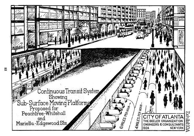
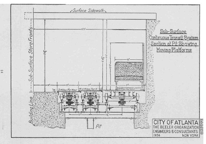
As you can see from the artist conceptions above, a secondary viaduct system would be built underneath Peachtree and Marietta streets that had three basic components:

1. A moving trolley of benches that person could walk up to and quickly get to different points around Downtown.

2. Two moving sidewalks (like those found on Airports) running at varying speeds of 4 and 2 miles per hour.

3. Basement level retail space with a normal, pedestrian only, sidewalk.

Above ground, pedestrians would have access to the system at various intersections not unlike a subway entrance, however no fare would ever be collected. Instead, funding of the system would come from taxing the surrounding business via some sort of sales tax.

There would be two lines:

North to south it would run under Peachtree starting at Mitchell Street and terminate at Carnegie Way at a length of about 3000 feet. West to East it would run under Marietta Street starting at Spring Street and what is now Peachtree Center Avenue at a length of about 2600 feet. The total distance covered by both routes would have been 5260 feet.

In addition to this system, the surface streets would be reconfigured to ease trolley and automobile congestion. This is where things took a turn for the crappy. The plan called for the following streets to become automobile only, proto-highway, streets (as in no sidewalks or pedestrian activity at all):

-Peachtree/Whitehall
-Spring
-Courtland

Other segments would become double decked to allow more automobile traffic, while other streets (unamed in the report) would solely have pedestrian and streetcar traffic.

There were also other flaws with this plan. The study showed that the Five Points intersection had 10,000 pedestrians per day. While that number sounds high, keep in mind that that Five Points Station today alone handles 50,000+ passengers per day on average. This does not account for the 10s of thousands of pedestrians that are in Downtown who drove there, or walked from other Downtown MARTA stations. Contrary to what many believe, pedestrian traffic during the day on Downtown sidewalks absolutely wallops that of the old days (but Downtown Atlanta at night today is absolutely crushed by the old days). In other words, had it been built, it would have not been able to be scaled up to meet the demands of the future since once the system was built, there was no way to expand it's capacity.

Another strike against the system (other than nothing like it has ever been done before and probably would have hard to pull off with the technology of hte day) is that there is a finite distance this type of transit can travel. It would only ever be useful in Downtown, and not for cross city travel. Basically, this sort of transit is built to order for what already exists. It could not be used to spur transit oriented development as the development is already there.

The cost to build this system, which isn't mentioned, probably wouldn't have been that cheaper than building a subway. The natural question then becomes, why not build a subway?

Fortunately, this crazy idea never saw the light of day. It is hard to say why, but chances are that the Great Depression killed this silly idea or was just flat out laughed out of the halls of city council. Below you can find a link to the report here (unfortunatley it is not the full report, and there is also evidence this may have been only one version of a proposed system):

http://jolomo.net/atlanta/continuous.html
Reply With Quote
     
     
  #11  
Old Posted Mar 21, 2012, 3:39 AM
RudyJK RudyJK is offline
Registered User
 
Join Date: Nov 2011
Location: Atlanta GA
Posts: 273
Map Mayhem

Thank you Testarossa for turning us on to the incredible map from the Return to Atlanta blog. The map is fascinating. I would love to go back to 1949 when the map was put together.

Check out all of the mansions on Peachtree around the area of the High. Incredible! And if you go up into Buckhead you can see many of the fine homes (many still standing) of Neel Reid and Philip Shutze.

I have spent too many hours on this map. Thanks again!
Reply With Quote
     
     
  #12  
Old Posted Aug 6, 2013, 3:41 AM
arjay57 arjay57 is offline
Registered User
 
Join Date: Jun 2013
Posts: 792
I'm not sure this is the right thread but it's definitely an interesting possibility for history buffs.

Quote:
The old World of Coca-Cola, the empty state-owned building at the edge of Underground Atlanta, could be the linchpin of a broader plan to remake Capitol Hill into a pedestrian-friendly tourist attraction. Gov. Nathan Deal is weighing whether to put millions of dollars into creating a state history museum at the site, which would also would house exhibits from the state sports and music halls of fame. State officials are also considering whether to turn nearby Mitchell Street into a pedestrian plaza, and an unsightly parking lot into a “protest area.”

More...Deal considers new state history museum
Reply With Quote
     
     
  #13  
Old Posted Aug 27, 2013, 9:02 PM
Stratosphere 2020's Avatar
Stratosphere 2020 Stratosphere 2020 is offline
Registered User
 
Join Date: Oct 2001
Location: Aruba
Posts: 1,664
Reply With Quote
     
     
  #14  
Old Posted Aug 31, 2013, 5:39 AM
L41A's Avatar
L41A L41A is offline
Registered User
 
Join Date: Jun 2007
Location: Peace Up, A-Town Down
Posts: 899
Quote:
Originally Posted by testarossa50 View Post
Anyone who is interested in Atlanta history, particularly history of landmarks that once were, should check out this awesome blog:

http://returntoatl.blogspot.com/

Basically a guy studies all sorts of different spots, shows what they looked like circa 1990 (when intown Atlanta was, in some ways, bottoming out before the new influx of wealth and redevelopment), and what they look like now. He also ties in historical photos and aerials.

In the blog, he links to GSU's collection of 1949 aerial photographs.

http://library.gsu.edu/aerialatlas1949/html/map.htm

I've decided to make gifs of them, to make them easy to compare with current aerials from Google Earth. Since each one takes a few minutes to make, I started out with only two areas, both of which have changed dramatically over the last 60 years: West Downtown and Buckhead.


A bunch of different things are interesting about these to me, but what continues to amaze me is how the makeshift layout of Atlanta's roads impacts the built environment today.

Also, it's simply incredible how dense and built up intown areas were in 1950, basically without a scrap of land going unused, and how completely some of those areas were razed. Below the GWCC used to sit a neighborhood with scores of houses, factories, and a railroad line--which are all but invisible today.
It is incredible how much more dense the Vine City area was and how it was more connected to Downtown before the GWCC and the Georgia Dome. With the upcoming construction of the new Atlanta Falcons stadium and the demolition of the Georgia Dome, I see the possibilities of better connecting the Vine City neighborhood with Downtown. A possibility that would presumably help to revitalize the Vine City neighborhood.

The Georgia Dome and the GWCC separates Vine City from Downtown. Andrew Young International Boulevard can be extended to Northside Drive and Magnolia Street to better connect Vine City to Downtown and the touristy COP.

My recent visits to the Vine City area has shown me the possibilities of the neighborhood and what it once was. It had schools, parks, corner stores, and today is still very walkable, with tree lined streets, with two nearby MARTA stations (Vine City and Ashby) in walking distance, and the commercial area at Lowery and MLK on one end and the burgeoning Castleberry on the other.
Reply With Quote
     
     
  #15  
Old Posted Aug 31, 2013, 12:00 PM
bryantm3 bryantm3 is offline
Registered User
 
Join Date: Feb 2012
Posts: 722
Quote:
Originally Posted by L41A View Post
It is incredible how much more dense the Vine City area was and how it was more connected to Downtown before the GWCC and the Georgia Dome. With the upcoming construction of the new Atlanta Falcons stadium and the demolition of the Georgia Dome, I see the possibilities of better connecting the Vine City neighborhood with Downtown. A possibility that would presumably help to revitalize the Vine City neighborhood.

The Georgia Dome and the GWCC separates Vine City from Downtown. Andrew Young International Boulevard can be extended to Northside Drive and Magnolia Street to better connect Vine City to Downtown and the touristy COP.

My recent visits to the Vine City area has shown me the possibilities of the neighborhood and what it once was. It had schools, parks, corner stores, and today is still very walkable, with tree lined streets, with two nearby MARTA stations (Vine City and Ashby) in walking distance, and the commercial area at Lowery and MLK on one end and the burgeoning Castleberry on the other.
i had to check that post to see if i had written it in my sleep, LOL! couldn't have said it better.
Reply With Quote
     
     
  #16  
Old Posted Sep 11, 2013, 1:23 PM
L41A's Avatar
L41A L41A is offline
Registered User
 
Join Date: Jun 2007
Location: Peace Up, A-Town Down
Posts: 899
Quote:
Originally Posted by bryantm3 View Post
i had to check that post to see if i had written it in my sleep, LOL! couldn't have said it better.
As the saying goes - Great minds think alike.
Reply With Quote
     
     
  #17  
Old Posted Sep 12, 2013, 4:19 AM
arjay57 arjay57 is offline
Registered User
 
Join Date: Jun 2013
Posts: 792
Quote:
Originally Posted by testarossa50 View Post
Also, it's simply incredible how dense and built up intown areas were in 1950, basically without a scrap of land going unused, and how completely some of those areas were razed. Below the GWCC used to sit a neighborhood with scores of houses, factories, and a railroad line--which are all but invisible today.
testa, I love your GIFs.

You know, in 1950 Atlanta had a population of 330,000 in only 50 square miles or so. That's a city wide density of around 6,600 p/sm.

I wonder what the population of that same area would be today? If someone had the time (and energy) to map out the census tracts that would be an interesting factoid.
Reply With Quote
     
     
  #18  
Old Posted Sep 20, 2013, 6:24 PM
waronxmas waronxmas is offline
Thought Criminal
 
Join Date: Feb 2010
Location: City of Atlanta Proper
Posts: 34
The Atlanta History Center posted this image of Midtown to their Tumblr last night:

1950


Today


Reply With Quote
     
     
  #19  
Old Posted Sep 21, 2013, 4:42 AM
atlantaguy's Avatar
atlantaguy atlantaguy is offline
Registered User
 
Join Date: Feb 2002
Location: Area code 404
Posts: 3,333
^Unreal!
Reply With Quote
     
     
  #20  
Old Posted Sep 21, 2013, 2:48 PM
Tuckerman Tuckerman is offline
Registered User
 
Join Date: Mar 2006
Location: Atlanta
Posts: 979
great photos - it has developed just a bit
Reply With Quote
     
     
This discussion thread continues

Use the page links to the lower-right to go to the next page for additional posts
 
 
Reply

Go Back   SkyscraperPage Forum > Regional Sections > United States > Southeast > Atlanta
Forum Jump


Thread Tools
Display Modes

Forum Jump


All times are GMT. The time now is 4:14 PM.

     
SkyscraperPage.com - Archive - Privacy Statement - Top

Powered by vBulletin® Version 3.8.7
Copyright ©2000 - 2024, vBulletin Solutions, Inc.