HomeDiagramsDatabaseMapsForum About
     

Go Back   SkyscraperPage Forum > Photography Forums > Found City Photos

Reply

 
Thread Tools Display Modes
     
     
  #44081  
Old Posted Nov 10, 2017, 1:17 AM
cjefferson cjefferson is offline
Registered User
 
Join Date: Nov 2017
Posts: 3
Quote:
Originally Posted by ethereal_reality View Post
Excellent Hoss.

Like you, I am totally surprised the white building with the boarded up windows is still standing. It was an eyesore then and it's an eyesore now.

And yet that beautiful Eaton's on Ventura Blvd. is gone.
__
the address of 2510 S. Central Avenue was at one time known as the Blodgett Building. In February 1962, it became the site of the very first law offices of attorney, and later to become Los Angeles Mayor, Tom Bradley when he entered into an association with attorney Charles H. Matthews who already had office space in that building.
Reply With Quote
     
     
  #44082  
Old Posted Nov 10, 2017, 1:33 AM
cjefferson cjefferson is offline
Registered User
 
Join Date: Nov 2017
Posts: 3
Quote:
Originally Posted by ethereal_reality View Post
Excellent Hoss.

Like you, I am totally surprised the white building with the boarded up windows is still standing. It was an eyesore then and it's an eyesore now.

And yet that beautiful Eaton's on Ventura Blvd. is gone.
__
This building was not only the original law office site for Attorney Tom Bradley, who later became Mayor of Los Angeles, but it was also the office site for the Los Angeles branch of the Urban League. In the California Eagle newspaper in Oct. 2, 1941, there is an article that recruited workers to come to this site to apply for mechanic jobs.
cjefferson
Reply With Quote
     
     
  #44083  
Old Posted Nov 10, 2017, 1:37 AM
cjefferson cjefferson is offline
Registered User
 
Join Date: Nov 2017
Posts: 3
Smile 2510 S. Central Avenue

this building was the original law office space occupied by Attorney Tom Bradley in 1962. He was in association with attorney Charles Matthews. The Los Angeles office of the Urban League was also in this building. There is an article in the California Eagle Oct 2, 1941 urging workers with mechanic skills to come apply for jobs. This building was known as the Blodgett Building...and i am sure it did not originally look like this.

cjefferson
Reply With Quote
     
     
  #44084  
Old Posted Nov 10, 2017, 2:05 AM
tovangar2 tovangar2 is offline
Registered User
 
Join Date: Nov 2012
Location: West Los Angeles
Posts: 2,625
2510 S. Central Avenue


I don't think the building was actually boarded up before; it just had some unfortunate-looking louvered sunshades over the windows. They were cleared away in 2016 or so, so the building looks like this now:


gsv
Reply With Quote
     
     
  #44085  
Old Posted Nov 10, 2017, 2:36 AM
ethereal_reality's Avatar
ethereal_reality ethereal_reality is online now
Registered User
 
Join Date: Feb 2008
Location: Lafayette/West Lafayette IN, Purdue U.
Posts: 16,351
Here's a look at those 'louvered sunshades' t2 just mentioned.


detail

See the complete slide HERE

Thanks for the information cjefferson. I didn't realize the building had such an interesting past.
I'm going to try and dig up some more info.
Reply With Quote
     
     
  #44086  
Old Posted Nov 10, 2017, 3:01 AM
ethereal_reality's Avatar
ethereal_reality ethereal_reality is online now
Registered User
 
Join Date: Feb 2008
Location: Lafayette/West Lafayette IN, Purdue U.
Posts: 16,351


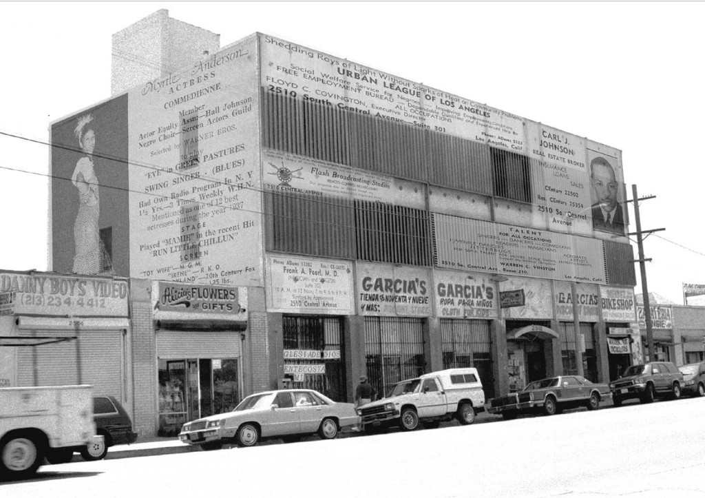
The Blodgett Building when it was, among other things, the home of the Urban League.


cwis.usc.edu

2150 South Central Avenue, 1940 and 1999.
The three-floor building with addresses beginning with 2150 was the home of many professional offices circa 1940.
Display advertisements from the Central Avenue Business Directory of 1940 are synthesized here with the 1999 fabric.
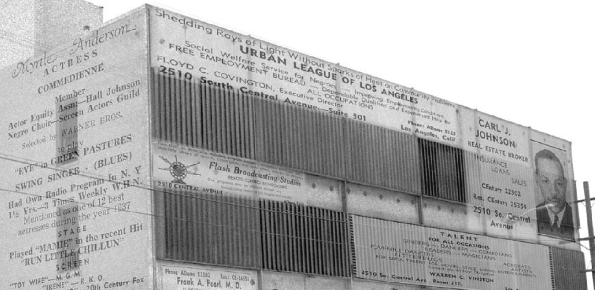
The Urban League, a leading civil rights organization, had its offices on the top floor in 1940.
Talent agents were busy signing neighborhood actors like Myrtle Anderson (side of building).
Real estate agents and physicians served a prosperous, mainly African American middle class.
In 1999 "Garcia's Tienda C[entavos] Noventa y Nueve" filled most of the first floor, catering to a primarily working-class Latino clientele.

Credit: Composition Philip J. Ethington © 2000.


here's a closer look at the top floor. (so you can read the information )


detail

Thanks for sparking my interest in this overlooked building cjefferson.
__

Now for Myrtle.
Reply With Quote
     
     
  #44087  
Old Posted Nov 10, 2017, 3:35 AM
ethereal_reality's Avatar
ethereal_reality ethereal_reality is online now
Registered User
 
Join Date: Feb 2008
Location: Lafayette/West Lafayette IN, Purdue U.
Posts: 16,351
Here's one of the damaged houses in the Portuguese Bend landslide.


https://books.google.com/books?id=5V...college&f=true

Last edited by ethereal_reality; Nov 10, 2017 at 4:39 AM.
Reply With Quote
     
     
  #44088  
Old Posted Nov 10, 2017, 4:37 AM
ethereal_reality's Avatar
ethereal_reality ethereal_reality is online now
Registered User
 
Join Date: Feb 2008
Location: Lafayette/West Lafayette IN, Purdue U.
Posts: 16,351
'mystery' location #1

I don't believe we have seen this fascinating depression era photograph on NLA.


ebay


reverse


Does anyone have an idea where this was taken?
__

Last edited by ethereal_reality; Nov 10, 2017 at 4:55 AM.
Reply With Quote
     
     
  #44089  
Old Posted Nov 10, 2017, 4:50 AM
ethereal_reality's Avatar
ethereal_reality ethereal_reality is online now
Registered User
 
Join Date: Feb 2008
Location: Lafayette/West Lafayette IN, Purdue U.
Posts: 16,351
'mystery' location #2

While trying to find more information on the above photograph, I came across a 2nd depression era photo taken from Los Angeles.

"Bread Line, 1933"


felix in hollywood

It looks as if the bread/soup kitchen is located in the building behind the 'The Champ' billboard.

so what is this building?

I thought one of you NLA'ers might be able to figure it out. (the sloped embankment in the distance look familiar but I can't pin it down)
__

Last edited by ethereal_reality; Nov 10, 2017 at 5:08 AM.
Reply With Quote
     
     
  #44090  
Old Posted Nov 10, 2017, 5:29 AM
CityBoyDoug CityBoyDoug is offline
BANNED
 
Join Date: Apr 2013
Posts: 2,868
Quote:
Originally Posted by ethereal_reality View Post
Here's one of the damaged houses in the Portuguese Bend landslide.


https://books.google.com/books?id=5V...college&f=true
In the 1980s I went to this place for the day. All day the cliff behind me was in motion....small rocks were falling on me all day. It was very strange....kinda fun.


https://web.csulb.edu/depts/geology/...pePortBendfarS

Last edited by CityBoyDoug; Nov 10, 2017 at 8:14 AM.
Reply With Quote
     
     
  #44091  
Old Posted Nov 10, 2017, 9:53 AM
BillinGlendaleCA BillinGlendaleCA is offline
Registered User
 
Join Date: Nov 2016
Posts: 570
Quote:
Originally Posted by Martin Pal View Post
The Dodger Stadium parking lots have 16,000 spaces. Are you suggesting two 8,000 capacity parking garages? No one would like that.

Also, greenery and foliage would be lovely, and there are many such islands around the stadium, but because of our recent long period of drought, with everyone in Los Angeles letting their greenery and foliage lay waste because there's no water to feed it, I doubt that kind of thing would be feasible now.

Cargo Collective

I don't know why a lot of people think a place needs to always be developed, either. Aerials of a hot stadium parking lot might look as appetizing as those bountiful postcards of the Los Angeles freeways, but you know what? Driving (or walking...yes walking) around the parking lots of Dodger stadium provide some of the most beautiful open air vistas of the city you can find.

Video Link


Also, money always comes into the picture. General parking costs at Dodger Stadium are $20 a car at the gate or $10 prepaid. Reserved parking close to the stadium is a lot more. (For the World Series the close lots were $70 to park (!) and the general parking was $40!) The parking lots make a ton of money for the place, which is one reason Frank McCourt, who made his money in the parking lot business, bought the team a few years ago and almost ran the organization into the ground before he was gotten rid of.

Of course, Dodger Stadium has Uber lots for drop-off and pickup or one can always walk to Dodger Stadium, too, from some locations, and save the parking fees!

Video Link

https://www.youtube.com/watch?v=-k6CA90Vpx8

I agree the area around the stadium could benefit from some things that would draw people there throughout the year. There was a plan a few years ago to almost make it a mall of sorts around there. Most people who go there for baseball, though, don't want the place obstructed by all these distractions. They like the openness and the, to quote the Andrews Sisters song, "Don't fence me in" quality you feel up there.

Also, the same complaint about the land around Dodger Stadium can be made about many other places, too: Angel Stadium for example.

O.C. Register


I tried to find information about that postcard, but only found the info written on the backside:

Dodger Stadium is surrounded by terraced parking for 16,000 cars and has 56,000 unobstructed-view seats with seven front rows, no posts and multi-colored levels which make it baseball's most beautiful park.

It may not have been a game of any significance. Dodger Stadium regularly sells out many times during any given year.
I've made the trek from Union Station to Dodger Stadium to get some city skyline shots. Another good place for shots of the city is above the Stadium, I was there last Sunday.

_B050252.jpg by me, on Flickr
Reply With Quote
     
     
  #44092  
Old Posted Nov 10, 2017, 6:43 PM
Martin Pal Martin Pal is offline
Registered User
 
Join Date: Sep 2013
Posts: 2,452


Bill, I checked out the other photos you have on your Flickr link. Very nice!
___

A couple posters recently referred to the Dodger Stadium parking lot and what a "heat island" it is. There's a whole lot of places like that now in Los Angeles. Yesterday I was reading about some actions to try and curb this problem.

From October 6:

Los Angeles is Painting Their Roads White to Cool the City Down and Improve Air Quality
In a first step towards tackling overheating, the city of Los Angeles is painting black asphalt roads with a white reflecting coating. It has been proven to reduce temperatures significantly.

Link HERE.
___

This article HERE, from May, talks about testing this out in Canoga Park.

Some of the articles call the sealant white and others refer to it as gray.


Another article HERE mentions a downside:

Of course, Jet Propulsion Laboratory climatologist Bill Patzert tells the Daily News that, while the “cool pavement” could help reverse the Heat Island Effect, it won’t be enough to offset the loss of urban forestland, should drought conditions cause vegetation to continue drying up in coming years.

Trial roads in all 15 council districts were coated with the reflective surfacing this past June.

Video Link


Dodger Stadium should do this in their parking lot.
Anyone else heard of this or seen it?
Reply With Quote
     
     
  #44093  
Old Posted Nov 10, 2017, 9:59 PM
jumbo0 jumbo0 is offline
Registered User
 
Join Date: Dec 2014
Posts: 17
I've been reading this topic for years but still didn't succeed in picking up on the large amount of posts passing here. I'm somewhere halfway I guess lol. I've posted some then/now's before but now -about a year later- I have a few more I'd like to share with you, especially some aerials. If they are posted before I apologize.


1927 vs 2017. LAX and surroundings


1928 vs 2017. Santa Clarita. The intersection of Lyons and Newhall hasn't changed a bit!


1929 vs 2017. West L.A. Santa Monica Blvd in the middle going from left to right. W. Pico Blvd in the bottom right.


1928 vs 2017. Santa Monica Airport and surroundings. Pico Blvd in the top left with just south of it Pearl St and one more south Ocean Park Blvd.


1928 vs 2017. Culver City. The biggest Blvd is Venice in the top left with Washington Blvd south of it. In about the middle we see National Blvd from left to right. Note the Hal Roach Studios on the intersection with National and Washington. They were famous for the Laurel and Hardy productions.


1933 vs 2017. Union Station. Main St just west of the fontain, Los Angeles st east of it (not sure if the names were the same back then) and Alameda St east of that. Note that the bend where the tracks used to be still is visible in the new buildings. That's sort of nice.. I guess.


1940 vs 2016. Bonvue Ave, Hollywood.


1930 vs 2016. Mines Field, now know as LAX.


1930 vs 2016. Southern Glass Company, Vernon.


1925 vs 2016. Warner Brothers Studios.


1931 vs 2016. Wilshire Blvd and Bronson Ave. Not too much has changed.


1945 vs 2016. Surv-all Market, Slauson Ave and Angeles Vista Blvd.

More to come!

Sources:
The Regents Of The University of California.
USC.
Reply With Quote
     
     
  #44094  
Old Posted Nov 11, 2017, 12:30 AM
Bristolian's Avatar
Bristolian Bristolian is offline
Registered User
 
Join Date: Jul 2015
Location: The Outskirts
Posts: 415
Quote:
Originally Posted by oldstuff View Post
Just below all of this in the surf is the wreck of the Greek freighter "Dominator" which ran aground in 1961. Parts of it can still be seen at low tide and some dive on the wreck
Here's what it looked like in 1965, about half of the ship still above water

Wikipedia
And what's left today

https://www.urbanghostsmedia.com/201...-palos-verdes/

What may be nothing more than urban legend is the thinking that the massive wheat cargo the ship was carrying spilled into the ocean and helped the local lobster population thrive for decades.

Last edited by Bristolian; Nov 11, 2017 at 7:11 AM.
Reply With Quote
     
     
  #44095  
Old Posted Nov 11, 2017, 2:23 AM
John Maddox Roberts John Maddox Roberts is offline
Registered User
 
Join Date: Aug 2014
Posts: 299
Quote:
Originally Posted by Bristolian View Post
Here's what it looked like in 1965, about half of the ship still above water

Wikipedia
And what's left today

https://www.urbanghostsmedia.com/201...-palos-verdes/

What may be nothing more than urban legend is the thinking that the massive wheat cargo the ship was carrying fell into the ocean and helped the local lobster population thrive for decades.
I used to see this wreck flying up the coast from LA to Santa Barbara. It always fascinated me, though I knew nothing of its story, lying on its side n the surf.
Reply With Quote
     
     
  #44096  
Old Posted Nov 11, 2017, 5:48 AM
Handsome Stranger's Avatar
Handsome Stranger Handsome Stranger is offline
Registered User
 
Join Date: May 2011
Location: Los Angeles, CA
Posts: 395


Here's the Dominator just a day or three after it ran aground. That's my mom on the left, expecting a little Handsome Stranger to emerge about eleven weeks later. (Not from the shipwreck.)

Last edited by Handsome Stranger; Nov 11, 2017 at 7:28 AM.
Reply With Quote
     
     
  #44097  
Old Posted Nov 11, 2017, 7:02 AM
ethereal_reality's Avatar
ethereal_reality ethereal_reality is online now
Registered User
 
Join Date: Feb 2008
Location: Lafayette/West Lafayette IN, Purdue U.
Posts: 16,351
You and I are about the same age Handsome Stranger.


Quote:
Originally Posted by jumbo0 View Post
I've been reading this topic for years but still didn't succeed in picking up on the large amount of posts passing here.
I'm somewhere halfway I guess . I've posted some then/now's before but now -about a year later-
I have a few more I'd like to share with you, especially some aerials.
Excellent post jumbo0! -I really enjoyed looking at all your before & afters.


1927 vs 2017. LAX and surroundings

This is Surfridge that I mentioned yesterday. (courtesy of FW)

LAX ghost town a home to memories and rare butterflies

__

Last edited by ethereal_reality; Nov 11, 2017 at 7:30 AM.
Reply With Quote
     
     
  #44098  
Old Posted Nov 11, 2017, 7:26 AM
CityBoyDoug CityBoyDoug is offline
BANNED
 
Join Date: Apr 2013
Posts: 2,868
Quote:
Originally Posted by Handsome Stranger View Post
Here's the Dominator just a day or three after it ran aground. That's my mom on the left, expecting a little Handsome Stranger to emerge about eleven weeks later.
SS Dominator, a freighter, ran ashore on the Palos Verdes Peninsula in the South Bay area of California in 1961 due to a navigational error while lost in fog. Its remains can still be seen today, and serves as a point of interest for hikers and kayakers.

Wrecked, 13 March 1961


https://i.pinimg.com/originals/94/80...bb59d53efb.jpg
Reply With Quote
     
     
  #44099  
Old Posted Nov 11, 2017, 8:32 PM
Flyingwedge's Avatar
Flyingwedge Flyingwedge is offline
Registered User
 
Join Date: Jun 2012
Location: Los Angeles
Posts: 1,127
Quote:
Originally Posted by Martin Pal View Post

Los Angeles is Painting Their Roads White to Cool the City Down and Improve Air Quality
In a first step towards tackling overheating, the city of Los Angeles is painting black asphalt roads with a white reflecting coating. It has been proven to reduce temperatures significantly.

Link HERE.
___

This article HERE, from May, talks about testing this out in Canoga Park.

Some of the articles call the sealant white and others refer to it as gray.


Another article HERE mentions a downside:

Of course, Jet Propulsion Laboratory climatologist Bill Patzert tells the Daily News that, while the “cool pavement” could help reverse the Heat Island Effect, it won’t be enough to offset the loss of urban forestland, should drought conditions cause vegetation to continue drying up in coming years.

Trial roads in all 15 council districts were coated with the reflective surfacing this past June.

Video Link


Dodger Stadium should do this in their parking lot.
Anyone else heard of this or seen it?
In Westchester, the short block of 77th Street between Cowan and Beland, next to Cowan Avenue School,
was covered with the heat-reducing coating:


FW photo
Reply With Quote
     
     
  #44100  
Old Posted Nov 11, 2017, 9:59 PM
CityBoyDoug CityBoyDoug is offline
BANNED
 
Join Date: Apr 2013
Posts: 2,868
Quote:
Originally Posted by Flyingwedge View Post
In Westchester, the short block of 77th Street between Cowan and Beland, next to Cowan Avenue School,
was covered with the heat-reducing coating:
Odd as this seems, it may actually work.
Reply With Quote
     
     
This discussion thread continues

Use the page links to the lower-right to go to the next page for additional posts

Reply

Go Back   SkyscraperPage Forum > Photography Forums > Found City Photos
Forum Jump


Forum Jump


All times are GMT. The time now is 12:46 AM.

     
SkyscraperPage.com - Archive - Privacy Statement - Top

Powered by vBulletin® Version 3.8.7
Copyright ©2000 - 2024, vBulletin Solutions, Inc.