HomeDiagramsDatabaseMapsForum About
     

Go Back   SkyscraperPage Forum > Regional Sections > Canada > Ontario > Ottawa-Gatineau > Business, Politics & the Economy


Reply

 
Thread Tools Display Modes
     
     
  #1  
Old Posted Feb 8, 2017, 5:02 PM
Uhuniau Uhuniau is online now
Registered User
 
Join Date: Jan 2010
Posts: 8,062
Canadian Population Census

Detail of the census tract map of Ott-Gat, showing the five-year population change.

Lots of intensification going on in large chunks of the core.

Lots of population decline in mature suburban areas, in line with the North American trend of smaller household sizes.


__________________
___
Enjoy my taxes, Orleans (and Kanata?).
Reply With Quote
     
     
  #2  
Old Posted Feb 8, 2017, 6:03 PM
rocketphish's Avatar
rocketphish rocketphish is offline
Planet Ottawa and beyond
 
Join Date: Feb 2009
Location: Ottawa
Posts: 12,405
Ottawa-Gatineau's population growth is mid-range compared to rest of Canada, census finds

Tom Spears, Ottawa Citizen
Published on: February 8, 2017 | Last Updated: February 8, 2017 12:09 PM EST


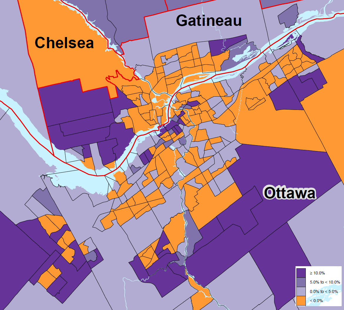
The population of the Ottawa-Gatineau region grew by 5.5 per cent in the five years leading up to last May’s census — a fairly middle-of-the-pack increase compared to much of Canada.

But as with many regions, it’s a significant slowdown from the growth of the previous five years from 2006 to 2011.

Meanwhile Calgary slipped by us to become the fourth-largest city in Canada, its population exploding by more than 180,000 in five years to reach 1.39 million. The top three remain Toronto, Montreal and Vancouver.


• There were 735,706 people in Ottawa last May, up more than 33,000 from five years earlier. There were 253,861 in Gatineau, up a little more than 10,000.

But these both represent a growth rate of a little less than five per cent. The larger census metropolitan area is bigger than Ottawa and Gatineau alone, and takes in outlying communities including Clarence-Rockland, Pontiac, Russell, Renfrew, Mississippi Mills, La Pêche and Chelsea.

Taken all together, the population of this larger metropolitan area is 1,323,783.

Some nearby towns are growing steadily: Rockland by 12 per cent in five years, Carleton Place up 10.2 per cent, Thurso up 15.2 per cent, Buckingham is up 6.4 per cent, and Arnprior 5.4 per cent. Some are mainly unchanged — Renfrew up 0.4 per cent and Cornwall up 0.5 per cent, while Perth is down a whisker, by 0.1 per cent.

Smiths Falls meanwhile lost 4.2 per cent of its population since 2011, while Papineauville is down by 6.5 per cent and Shawville down 3.5 per cent.

• Our growth in the past five years is slightly slower than the mega-regions of Vancouver (6.5 per cent) and Toronto (6.2 per cent). It’s a little ahead of Montreal (4.2 per cent) and Quebec City (4.0), and leaves us settled right in the middle of the range for many Southern Ontario census areas — London, Hamilton, Oshawa, Niagara, and so on, all growing at a rate that averages about one per cent each year.

We are slightly ahead of Canada’s overall population increase of 5.0 per cent.

• The capital region is far behind Calgary and Edmonton, which lead the nation at 14.6 and 13.9 per cent, respectively.

• The capital’s growth is, however, a major slowdown from the previous five-year period, when we grew by 9.0 per cent. That increase was far greater than the national average of 5.9 per cent.

• Elsewhere in Eastern Ontario’s urban areas there has been little growth since 2011. Kingston’s population grew by 1.0 per cent and Belleville’s by 1.8 per cent.

• The number of private dwellings in Ottawa-Gatineau rose by seven per cent, from 370.217 to 395,985. That’s faster than in most parts of Canada, though slower than Vancouver, Calgary, Edmonton, and some Toronto suburbs.

In Gatineau the number of private homes rose by 6.4 per cent, to 152,958.

More to come.

tspears@postmedia.com
twitter.com/TomSpears1

http://ottawacitizen.com/news/local-...a-census-finds
Reply With Quote
     
     
  #3  
Old Posted Feb 8, 2017, 6:15 PM
zzptichka zzptichka is online now
Registered User
 
Join Date: Dec 2015
Location: Outaouias
Posts: 1,748
Reply With Quote
     
     
  #4  
Old Posted Feb 8, 2017, 11:06 PM
1overcosc's Avatar
1overcosc 1overcosc is offline
Registered User
 
Join Date: Jun 2013
Location: Kingston, Ontario
Posts: 11,501
Quote:
Originally Posted by Uhuniau View Post
Detail of the census tract map of Ott-Gat, showing the five-year population change.

Lots of intensification going on in large chunks of the core.

Lots of population decline in mature suburban areas, in line with the North American trend of smaller household sizes.


We had a thread somewhere on here with the 2011 version of this map. Would be nice to see a comparison.
Reply With Quote
     
     
  #5  
Old Posted Feb 8, 2017, 11:09 PM
1overcosc's Avatar
1overcosc 1overcosc is offline
Registered User
 
Join Date: Jun 2013
Location: Kingston, Ontario
Posts: 11,501
The zoomed out version of the map is interesting as it shows something quite different from the past:


Growth in the rural/exurban areas of the city seems to have really slowed. Lots of census tracts outside the urban area are orange--a good chunk of Cumberland, the area around Marlborough Forest, Fitzroy Harbour area, Russell Township & Clarence-Rockland outside the village cores, and Chelsea are all orange.
Reply With Quote
     
     
  #6  
Old Posted Feb 9, 2017, 2:04 AM
rocketphish's Avatar
rocketphish rocketphish is offline
Planet Ottawa and beyond
 
Join Date: Feb 2009
Location: Ottawa
Posts: 12,405
Census reveals some dramatic changes within capital region

James Bagnall, Ottawa Citizen
Published on: February 8, 2017 | Last Updated: February 8, 2017 8:28 PM EST


On the face of it, the capital region’s population growth doesn’t seem like much: An increase of 5.5 per cent over five years to 1,323,783.

That’s true even if it was a touch faster than the five per cent increase to 35,151,728 experienced by Canada as a whole.

But the overall average released Wednesday — part of the first datasets published following the 2016 census — disguises some profound changes to our region.

Here’s what Statistics Canada found after dividing Ottawa and Gatineau into 277 census tracts. First, the big breakdown — the census recorded a 5.8 per cent gain for Ottawa alone (to 924,243) and 4.1 per cent for Gatineau (to 276,245).

Now, look at the detail: The top 25 tracts each registered population growth in excess of 18 per cent over five years. Roughly speaking, the majority are clustered in three areas — Ottawa South, Kanata and Gatineau West (formerly Aylmer).

Anyone who commutes from these districts will recognize these are bedroom communities serving different parts of the city. Each has a mixture of brand new, lower-cost housing developments, studded with upper-end enclaves.

The biggest gain in population — 109 per cent — was recorded in the census tract northwest of Manotick, immediately to the east of Highway 416 and north of Barnsdale Road. It is anchored by the Stonebridge Golf and Country Club, once situated in an open meadow but now completely surrounded by new housing.

Three of the 10 fastest growing census tracts were in Kanata — reflecting the rising concentration of high-tech. During the 2011 census, the sector had yet to recover from the bankruptcy of Nortel — whose assets had just been divvied up and sold off. More recently, the companies that acquired those assets — Ciena and Ericsson in particular — have invested significantly in their Kanata operations. At the same time, high-tech firms specializing in telecommunications and software have formed a tight cluster, most notably in the northern part of Kanata.


The result has been to stimulate new housing. Five of Kanata’s 19 census tracts experienced population growth in excess of 22 per cent between 2011 and 2016. The biggest gain was recorded in the census tract that links north and south Kanata to the west of Goulbourn Forced Road.

One of the oddest findings of the latest census is that so much rapid population growth occurred within west Gatineau. While this region has long served as a community for employees of the federal government — particularly among francophones — StatCan conducted its 2011 census when the number of government employees was near its all-time peak of 148,000 locally. Since then, federal government employment has slipped about 10 per cent.

All things being equal, the area should have seen very weak population growth, if not a reversal. Yet multiple tracts adjacent to Chemin Antoine-Boucher saw increases of at least 20 per cent over five years. New housing developments featuring lower prices than are available on the Ottawa side of the river no doubt had an influence.

Clues about the source of the growth will be available later. Census data detailing the age, occupation, language and other variables of inhabitants will be released in stages as the year progresses.

Other parts of Gatineau fared less well between the two census periods in terms of population increases. Five of the ten census tracts that saw the biggest declines in people were in Gatineau — including areas adjacent to Lac Leamy and in east Gatineau.

On the Ontario side, the census tract that lost the most population between 2011 and 2016 included the downtown strip just west of Bronson Avenue and north of the Queensway.

There was another shock, nationally speaking, even though we knew it was inevitable.

Not only did Calgary overtake Ottawa-Gatineau as the country’s fourth most populous metro area but Edmonton’s tally fell just a couple of thousand short. There seems little doubt we’ll soon be No. 6.

Despite the negative impact in Alberta of an energy recession, the population of Calgary and Edmonton jumped 14.6 per cent and 13.9 per cent respectively between 2011 and 2016.

jbagnall@postmedia.com

http://ottawacitizen.com/news/local-...capital-region
Reply With Quote
     
     
  #7  
Old Posted Feb 9, 2017, 3:30 AM
1overcosc's Avatar
1overcosc 1overcosc is offline
Registered User
 
Join Date: Jun 2013
Location: Kingston, Ontario
Posts: 11,501
Quote:
Originally Posted by rocketphish View Post
On the Ontario side, the census tract that lost the most population between 2011 and 2016 included the downtown strip just west of Bronson Avenue and north of the Queensway.
I wonder if that stems from the closure of that massive building on Bell Street for renovations.
Reply With Quote
     
     
  #8  
Old Posted Feb 9, 2017, 2:31 PM
lrt's friend lrt's friend is offline
Registered User
 
Join Date: Dec 2006
Posts: 11,893
In one place it says Ottawa's population is 735K and in another 924K and elsewhere, a total greater metro population of 1.323M . I sort of get the last figure, but the difference between the first two I don't get. Does the 735K not include the full population within the city's municipal boundaries? It seems that way because, I have heard for years figures of at least 850K. If not the entire population, why is it being published? It is almost like they are only including the former city of Ottawa, Nepean and Gloucester in the 735K, or something like that. It just seems that the 735K figure is bogus and does not relate to current reality.
Reply With Quote
     
     
  #9  
Old Posted Feb 9, 2017, 2:43 PM
McC's Avatar
McC McC is offline
Registered User
 
Join Date: Apr 2010
Posts: 3,057
it'd be nice to see a map showing absolute changes; 100% increases of small numbers in brand new greenfield areas of the region are not nearly as interesting to me as >10% increases of potentially larger numbers in more established parts of the city.
Reply With Quote
     
     
  #10  
Old Posted Feb 9, 2017, 2:50 PM
Acajack's Avatar
Acajack Acajack is offline
Unapologetic Occidental
 
Join Date: Aug 2006
Location: Province 2, Canadian Empire
Posts: 68,143
Quote:
Originally Posted by lrt's friend View Post
In one place it says Ottawa's population is 735K and in another 924K and elsewhere, a total greater metro population of 1.323M . I sort of get the last figure, but the difference between the first two I don't get. Does the 735K not include the full population within the city's municipal boundaries? It seems that way because, I have heard for years figures of at least 850K. If not the entire population, why is it being published? It is almost like they are only including the former city of Ottawa, Nepean and Gloucester in the 735K, or something like that. It just seems that the 735K figure is bogus and does not relate to current reality.
The 735k is an alternative (and screwed up IMO0) metric that is called the "urban area" or the contiguously built-up area. The 924k is the actual population within city limits.

The 735k doesn't include certain areas separated from central Ottawa by the Greenbelt, or at least where the Greenbelt is wide enough for StatsCan to consider them non-contiguous to Ottawa.

It's dumb.
__________________
The Last Word.

Last edited by Acajack; Feb 9, 2017 at 3:04 PM.
Reply With Quote
     
     
  #11  
Old Posted Feb 9, 2017, 2:52 PM
Uhuniau Uhuniau is online now
Registered User
 
Join Date: Jan 2010
Posts: 8,062
Ooooh this is fun:

https://censusmapper.ca
__________________
___
Enjoy my taxes, Orleans (and Kanata?).
Reply With Quote
     
     
  #12  
Old Posted Feb 9, 2017, 3:05 PM
lrt's friend lrt's friend is offline
Registered User
 
Join Date: Dec 2006
Posts: 11,893
Quote:
Originally Posted by Acajack View Post
The 735k is an alternative (and screwed up IMO0) metric that is called the "urban area" or the contiguously built-up area. The 924k is the actual population within city limits.

The 735k doesn't include certain areas separate by central Ottawa by the Greenbelt, or at least where the Greenbelt is wide enough for StatsCan to consider them non-contiguous to Ottawa.

It's dumb.
Even that doesn't make sense because the population of the three major communities outside the Greenbelt is at least 300,000. To see this figure being compared to other cities in Canada just doesn't give a true picture. It makes Ottawa look smaller than it is.
Reply With Quote
     
     
  #13  
Old Posted Feb 9, 2017, 3:05 PM
Acajack's Avatar
Acajack Acajack is offline
Unapologetic Occidental
 
Join Date: Aug 2006
Location: Province 2, Canadian Empire
Posts: 68,143
Interesting that on the Quebec side the true exurban areas are all growing except Chelsea.

Chelsea is the oldest exurb and also the most expensive, so it's probably got a more "built-out" (by exurban standards anyway) character than the others do.
__________________
The Last Word.
Reply With Quote
     
     
  #14  
Old Posted Feb 9, 2017, 3:10 PM
Acajack's Avatar
Acajack Acajack is offline
Unapologetic Occidental
 
Join Date: Aug 2006
Location: Province 2, Canadian Empire
Posts: 68,143
Quote:
Originally Posted by lrt's friend View Post
Even that doesn't make sense because the population of the three major communities outside the Greenbelt is at least 300,000. To see this figure being compared to other cities in Canada just doesn't give a true picture. It makes Ottawa look smaller than it is.
I just checked and Orleans and Barrhaven are in the urban area, but Kanata (and all of the rural areas all around the city) is not.

I agree that it makes no sense. Both Orleans and Barrhaven are also separated by non-urbanized land from the central area, but the space for Kanata is "just enough"...
__________________
The Last Word.
Reply With Quote
     
     
  #15  
Old Posted Feb 9, 2017, 3:16 PM
McC's Avatar
McC McC is offline
Registered User
 
Join Date: Apr 2010
Posts: 3,057
Quote:
Originally Posted by McC View Post
it'd be nice to see a map showing absolute changes; 100% increases of small numbers in brand new greenfield areas of the region are not nearly as interesting to me as >10% increases of potentially larger numbers in more established parts of the city.
Quote:
Originally Posted by Uhuniau View Post
Ooooh this is fun:

https://censusmapper.ca

ah, thank you; ask and you shall receive!
https://censusmapper.ca/maps/585#13/45.4024/-75.7001
Reply With Quote
     
     
  #16  
Old Posted Feb 9, 2017, 3:46 PM
Acajack's Avatar
Acajack Acajack is offline
Unapologetic Occidental
 
Join Date: Aug 2006
Location: Province 2, Canadian Empire
Posts: 68,143
Quote:
Originally Posted by McC View Post
ah, thank you; ask and you shall receive!
https://censusmapper.ca/maps/585#13/45.4024/-75.7001
Why is Ottawa only in one big block whereas other cities can be viewed in census tracts when you zoom in?
__________________
The Last Word.
Reply With Quote
     
     
  #17  
Old Posted Feb 9, 2017, 4:26 PM
McC's Avatar
McC McC is offline
Registered User
 
Join Date: Apr 2010
Posts: 3,057
it was sketchy for me too, but I did get it to work once.
Reply With Quote
     
     
  #18  
Old Posted Feb 9, 2017, 4:39 PM
J.OT13's Avatar
J.OT13 J.OT13 is offline
Moderator
 
Join Date: Mar 2012
Location: Ottawa
Posts: 24,084
Quote:
Originally Posted by Acajack View Post
Why is Ottawa only in one big block whereas other cities can be viewed in census tracts when you zoom in?
If you take Uhuniau's link and head east to Ottawa, you'll get the census tracts.
Reply With Quote
     
     
  #19  
Old Posted Feb 9, 2017, 5:00 PM
Radster Radster is offline
Registered User
 
Join Date: Oct 2007
Location: Chelsea
Posts: 997
Quote:
Originally Posted by Acajack View Post
Interesting that on the Quebec side the true exurban areas are all growing except Chelsea.

Chelsea is the oldest exurb and also the most expensive, so it's probably got a more "built-out" (by exurban standards anyway) character than the others do.

Chelsea, although a large area, limits new lots to at least 1 acre, and there is very limited amount of lots left for sale, and those that are available are often at least $100K for an acre. I just moved to Chelsea, in Farm Point, into a beautiful 10yr old pre-fab home, on a 1.25acre lot, no immediate neighbours, 1 minute to the Hwy 5 onramp, for $325K! It was literally a steal! Takes me 20 minutes to get to work in Portage, with almost zero traffic. But we looked for 6 months, it was nearly impossible to find something in our price range (under $350K) that was not an old fixer-upper.

On another note, I suspect that come next Census, La Peche will have a big spike, now that HWY 5 is extended.
Reply With Quote
     
     
  #20  
Old Posted Feb 9, 2017, 5:15 PM
Acajack's Avatar
Acajack Acajack is offline
Unapologetic Occidental
 
Join Date: Aug 2006
Location: Province 2, Canadian Empire
Posts: 68,143
Quote:
Originally Posted by Radster View Post
Chelsea, although a large area, limits new lots to at least 1 acre, and there is very limited amount of lots left for sale, and those that are available are often at least $100K for an acre. I just moved to Chelsea, in Farm Point, into a beautiful 10yr old pre-fab home, on a 1.25acre lot, no immediate neighbours, 1 minute to the Hwy 5 onramp, for $325K! It was literally a steal! Takes me 20 minutes to get to work in Portage, with almost zero traffic. But we looked for 6 months, it was nearly impossible to find something in our price range (under $350K) that was not an old fixer-upper.

On another note, I suspect that come next Census, La Peche will have a big spike, now that HWY 5 is extended.
Due to a variety of factors, Chelsea is more selective and stringent when it comes to new developments.

Based on what I've seen, it's a bit more of a free for all in Cantley and Val-des-Monts.
__________________
The Last Word.
Reply With Quote
     
     
This discussion thread continues

Use the page links to the lower-right to go to the next page for additional posts
 
 
Reply

Go Back   SkyscraperPage Forum > Regional Sections > Canada > Ontario > Ottawa-Gatineau > Business, Politics & the Economy
Forum Jump


Forum Jump


All times are GMT. The time now is 4:02 AM.

     
SkyscraperPage.com - Archive - Privacy Statement - Top

Powered by vBulletin® Version 3.8.7
Copyright ©2000 - 2024, vBulletin Solutions, Inc.