So I just drove from Ottawa to Winnipeg (final destination: Regina) via the highway north of Lake Superior. While the rugged terrain and the vistas of the Lake are spectacular, this region is not conducive to easy transportation and establishment of population centres. So this got me thinking of two bad decisions out of the British House of Commons.
The first was after the AWR and the Treaty of Paris where the British negotiators gave the "Old North West" to the rebels with the thought that the new country was so unstable that they would fall back into the empire in due course.
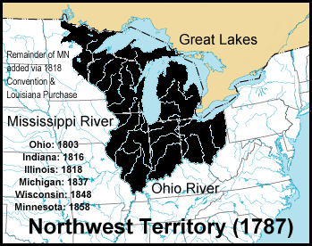
Also for some strange reason northern Maine was also given to the young republic.

It is said that while the War of 1812 was a draw, the Americans were triumphant at the peace table. This was due to British indifference, American good luck (the victory at New Orleans, and the Federalist threat to take New England out of the Union right at the time of the news of Jackson's victory) and that the British were pre-occupied with settling post Napoleonic France.
https://www.thecanadianencyclopedia....reaty-of-ghent
Let us say the British were a little more hard nosed and with the fact that the British had control of Mackinac Island, BNA (Canada) development could be very different.

Mackinac Island was a strategic island that controlled the fur trade of the "Old Northwest in the years between the ARW and the War of 1812. Even after the Peace Treaty was signed the British kept control of the island until the Governor of BNA forced the British troops there to leave.
With the Upper Peninsula of Michigan under Canadian control the western border with the US could arguably be the 45.75 Parallel (starting at the mouth of the Ford River south of Escanaba Michigan) and that area would include the territory north of the mouth of Columbia river. This area would include Washington, Idaho pan-handle, most of Montana, all of North Dakota, half of Minnesota, Northern Wisconsin and of course the UP of Michigan.
How would Canada develop if we didn't have to deal with the harshness of the terrain north of Superior? Would this country be stronger with an easier and more tangible (transportation and population wise) connection between western and central Canada?


 Prev
Prev


 Maybe give me 10 years to figure something out on paper.


 Linear Mode
