HomeDiagramsDatabaseMapsForum About
     

Go Back   SkyscraperPage Forum > Regional Sections > Canada


Reply

 
Thread Tools Display Modes
     
     
  #41  
Old Posted Apr 20, 2017, 9:40 PM
Architype's Avatar
Architype Architype is offline
♒︎ Empirically Canadian
 
Join Date: Mar 2004
Location: 🍁 Canada
Posts: 11,998
Quote:
Originally Posted by Franco401 View Post
Saint John is fairly unique among Canadian cities its size in that it doesn't have a "downtown". The Central Business District is referred to as Uptown Saint John due to its position at the top of a hill. There's never been a "downtown",...
Uptown, in this case, really means the same thing, just a different term for it.

The concept and useage of "up" and "down" in geography is interesting. It usually relates well to North and South conventions, also to rivers and travel on the ocean. Many Canadian cities happen to have water and the ports to the south, (New York is somewhat similar with Lower Manhatten being downtown), further reinforcing the concept of "downtown", as being south and next to the ocean, often on lower land, and the oldest part of the city which also became the downtown commercial area. These conventions aren't always the case however; In Nfld., you go "up" to St. John's from other areas of the province (even though it is south), but when you get there, you are also "downtown". You also go "up" to Toronto from Nfld. and the Maritimes, but when you get there you may also be "downtown". Vancouver's downtown qualifies as being next to the port and near the ocean, and on lower land, but is North and West, although its seperation from the rest of the city further identifies its status.

Last edited by Architype; Apr 20, 2017 at 9:52 PM.
Reply With Quote
     
     
  #42  
Old Posted Apr 20, 2017, 10:22 PM
TorontoDrew's Avatar
TorontoDrew TorontoDrew is offline
Registered User
 
Join Date: Nov 2014
Posts: 9,790
I really feel like the red section should cross the DVP to Carlaw and extend to Danforth. Hell it's going to have 2 DRL stops located in it. Also Cabbagetown is a no brainer as part of downtown.
Reply With Quote
     
     
  #43  
Old Posted Apr 20, 2017, 11:00 PM
WhipperSnapper's Avatar
WhipperSnapper WhipperSnapper is offline
I am the law!
 
Join Date: Sep 2002
Location: Toronto+
Posts: 22,006
The city of toronto's definition of the downtown area has always been the best in my books. I do prefer the older boundaries than the updated version.

I believe the older boundaries were The Don, Davenport, the lake and, Bathurst above Queen extending to Dufferin below Queen. The revised version is just Bathurst from the Lake to Davenport.
Reply With Quote
     
     
  #44  
Old Posted Apr 21, 2017, 1:12 AM
Docere Docere is offline
Registered User
 
Join Date: Jul 2014
Posts: 7,364
Quote:
Originally Posted by Architype View Post
The concept and useage of "up" and "down" in geography is interesting. It usually relates well to North and South conventions, also to rivers and travel on the ocean. Many Canadian cities happen to have water and the ports to the south, (New York is somewhat similar with Lower Manhatten being downtown), further reinforcing the concept of "downtown", as being south and next to the ocean, often on lower land, and the oldest part of the city which also became the downtown commercial area.
Yes, and "downtown" does work as a directional in Toronto. North is also uphill and there's a bit of a psychological element to going "up the hill" above Dupont, just as there is crossing the Don River.
Reply With Quote
     
     
  #45  
Old Posted Apr 21, 2017, 1:20 AM
Docere Docere is offline
Registered User
 
Join Date: Jul 2014
Posts: 7,364
The "advantage" to using Bathurst for the boundary of the west, Don River as the boundary for the east and north of St. Clair (or specifically the Belt Line Trail) is its simplicity. The east gets a geographic marker, North Toronto doesn't "interfere with" the west end. Only question is where do the Annex, Rosedale and Yonge-St. Clair fit? Downtown maybe fits within the central area.
Reply With Quote
     
     
  #46  
Old Posted Apr 21, 2017, 1:49 AM
shappy's Avatar
shappy shappy is offline
Registered User
 
Join Date: Mar 2004
Posts: 2,238
Quote:
Originally Posted by MonkeyRonin View Post
I see it just working something like this - with the red area corresponding to the Downtown core and the green being a sort of "Greater Downtown" (give or take the boundaries a bit):

I pretty much agree with this and like the idea of distinguishing between downtown and surrounding central neighbourhoods. I suppose a rule of thumb IMO is if I feel like I'm in a neighbouhood then I'm probably not downtown. Cabbagetown, Kensington, Riverside, Annex, Niagara, etc... these are all distinct areas where the neighbourhood feel dominates.
Reply With Quote
     
     
  #47  
Old Posted Apr 22, 2017, 4:05 AM
Docere Docere is offline
Registered User
 
Join Date: Jul 2014
Posts: 7,364
I just calculated the population for what called the downtown core, covering Bathurst/University to Jarvis, Davenport to the lake.*

In the 2016 census, there were 121,669 people in this area of 6.6 square km or 2.5 square miles.

I haven't bothered to do the "official" Bathurst to Don defintion, which covers 17 square km or 6.5 square miles, which is fine as a greater downtown but a little large to be the downtown core or "downtown" for comparative purposes IMO.

* Census tracts 11-15, 34-35, 62-63, 88, 89
Reply With Quote
     
     
  #48  
Old Posted Apr 24, 2017, 12:30 AM
Docere Docere is offline
Registered User
 
Join Date: Jul 2014
Posts: 7,364
So the Spadina to Roncy hipster belt is part of greater downtown?

It used to be that hipster/bohemian neighborhoods used to be on the edge of downtown (i.e. Gerrard St. in the 50s, Yorkville and the Annex in the 60s and 70s) but now they basically "own" the west end.

Last edited by Docere; Apr 24, 2017 at 12:41 AM.
Reply With Quote
     
     
  #49  
Old Posted Apr 24, 2017, 7:43 AM
osmo osmo is offline
Registered User
 
Join Date: Nov 2005
Posts: 1,716
The western edge for downtown in Toronto is Spadina. For all the major east west streets try become more transitional west of Spadina.

In the east it is Sherbourne as nobody considers River street downtown. Parliament is a good comparable to Bathurst IMO for the east end. The transition points are important as less intensive uses and structures find a good place in these areas

City planners created the Bathurst to the Don River thing. On the ground it isn't what is there now. Locals from the old Boroughs also tend to get lazy and will call anything from High Park to the Don "downtown".

Toronto has a massive downtown as it is. Some parts I only ever see once or twice a year. I don't remember the last time I was at Avenue and Bloor for example.
Reply With Quote
     
     
  #50  
Old Posted Apr 29, 2017, 11:39 PM
HillStreetBlues HillStreetBlues is offline
Registered User
 
Join Date: Apr 2013
Location: KW/Hamilton, Ontario
Posts: 995
Quote:
Originally Posted by Beedok View Post
Hamilton's is really blurry. Partly because people on the mountain consider practically the whole lover city 'downtown'. But for a more standard count... Bay, Hunter, Wellington, and Cannon maybe?
When I lived in Hamilton, I was between Dundurn and Locke, and my coworkers considered me to be living downtown. I lived in Kirkendall, and even longtime Hamiltonians from the Mountain would sometimes not know what that was, and try to insist that I lived downtown. I knew one person who lived near Ottawa Street, and would get exasperated when someone implied that was downtown- really, it was quite a trek downtown for her. I think that your boundaries are pretty close, but that James South might be part of it, and the western boundary may be Queen.

I think this confusion about what constitutes "downtown" is common to a lot of smaller Canadian cities. Folks who live in older neighbourhoods or streetcar suburbs can see the clear distinction between their 'hoods and the central business district. Suburbanites might see (relatively) dense urban neighbourhoods as all part of one huge "downtown." Here in Kitchener, I live in a neighbourhood close to downtown but absolutely not part of it, but a lot of people (coworkers) just lump my area in with downtown. Kitchener's downtown is bordered by Victoria, Cedar (maybe a bit further east), Weber and Courtland.

I'm from London but don't know the boundaries of its downtown. Is Dufferin the boundary? Or is Richmond Row now part of downtown, either de facto or officially?
Reply With Quote
     
     
  #51  
Old Posted May 1, 2017, 5:35 AM
Docere Docere is offline
Registered User
 
Join Date: Jul 2014
Posts: 7,364
Quote:
Originally Posted by osmo View Post
The western edge for downtown in Toronto is Spadina. For all the major east west streets try become more transitional west of Spadina.

In the east it is Sherbourne as nobody considers River street downtown. Parliament is a good comparable to Bathurst IMO for the east end. The transition points are important as less intensive uses and structures find a good place in these areas

City planners created the Bathurst to the Don River thing. On the ground it isn't what is there now. Locals from the old Boroughs also tend to get lazy and will call anything from High Park to the Don "downtown".

Toronto has a massive downtown as it is. Some parts I only ever see once or twice a year. I don't remember the last time I was at Avenue and Bloor for example.
I included over to Bathurst in one census tract only (tract 11), which is centered along King St. from University to Bathurst, in my downtown population count.
Reply With Quote
     
     
  #52  
Old Posted May 1, 2017, 3:52 PM
KnoxfordGuy's Avatar
KnoxfordGuy KnoxfordGuy is online now
New Brunswick booster!
 
Join Date: Jan 2011
Location: Fredericton, New Brunswick
Posts: 1,630
This is what I would consider to be downtown Fredericton.

From Google Maps:

Untitled by James McGrath, on Flickr
__________________
Fredericton. Noble Daughter Of The Forest.
Reply With Quote
     
     
  #53  
Old Posted Nov 22, 2017, 11:49 PM
Docere Docere is offline
Registered User
 
Join Date: Jul 2014
Posts: 7,364
Population of the Bathurst to Don "greater downtown" Toronto was 237,698 in the 2016 census.
Reply With Quote
     
     
  #54  
Old Posted Nov 23, 2017, 1:42 AM
megadude megadude is online now
Registered User
 
Join Date: Sep 2017
Location: N. York/Bram/Mark/Sauga/Burl/Oak/DT
Posts: 3,059
Those Calgary and Fredericton examples look like pretty clear delineations of downtowns. From those satellite views it looks like a clear demarcation between the DT area and the rest. Interesting.
Reply With Quote
     
     
  #55  
Old Posted Nov 23, 2017, 2:13 AM
Nouvellecosse's Avatar
Nouvellecosse Nouvellecosse is offline
Volatile Pacivist
 
Join Date: Aug 2005
Location: Nova Scotia
Posts: 9,077
Quote:
Originally Posted by Drybrain View Post
Halifax is one that has a few different permutations.

At minimum would be this, which includes the historic main street and waterfront, financial area, legislature, and much of the oldest architecture.


In recent years, however, I'd make the argument that the commercial stretches along Water, Barrington and Hollis streets have become more or less continuous with the rest of downtown. The fact that they extend to the city's main train station (little-used though it is) and central market seem to bolster that. They also contain a similarly rich mix of 18th, 19th, and 20th-century architecture


The stretch heading west along Spring Garden Road to Robie has seen a dramatic spike in new development and tall buildings. Ten years ago it would have been more of an adjunct to downtown--an Annex type of neighbourhood. Today, the scale of development (and again, continuous mixed-use streetwalls connected to the rest of downtown) is quickly making it feel a lot more urban, extending west along this corridor and out of frame for a bit.


And finally, on the left side, Gottingen Street (where the arrow is) used to be a main commercial arterial branching north (this map is oriented with north on the left and east on the top). That neighbourhood was considered by many to be downtown, though in the 1960s the city destroyed a huge swath of the central city, severing the areas above and below Cogswell Street from one another. Cogswell is the red line marking the far left extent of downtown on the first three maps).

Gottingen sort of atrophied like a disused limb at that point, and I think it's fair to say that it can't really be considered downtown anymore, though some people will fight the point. It's seeing gentrification/revitalization now, however, so who knows in the future.
Personally I'd consider the last one to be the most accurate although I've never included the Centennial pool as part of downtown.

I'd define it as:

__________________
"The reasonable man adapts himself to the world; the unreasonable one persists in trying to adapt the world to himself. Therefore all progress depends on the unreasonable man." - George Bernard Shaw
Don't ask people not to debate a topic. Just stop making debatable assertions. Problem solved.
Reply With Quote
     
     
  #56  
Old Posted Nov 23, 2017, 2:38 AM
Andy6's Avatar
Andy6 Andy6 is offline
Starring as himself
 
Join Date: Mar 2002
Location: Toronto Yorkville
Posts: 9,739
Downtown is a part of the city that virtually every normal person in the city would be familiar with (e.g., while there, could usually give basic directions to a downtown landmark to a tourist). Ossington or St. Clair are somewhat central areas of Toronto but they aren't known as universally as Yonge or University are. Every Winnipegger has, at some point, walked around (if not across) the Portage and Main intersection while relatively few have walked around (say) Portage and Broadway, even though the latter is still central and familiar from driving by in one's car.

That's not a sufficient condition, of course, but it is (close to) a necessary one. There would also need to be a reference to the traditional headquarters of businesses and of many one-of-a-kind establishments (department stores, medical offices perhaps, concert venues, etc.) -- again because these places need to be accessible to the residents of the entire city and therefore tend to locate in a place that all residents would know.

What did Mel Lastman do when he decided that North York needed a downtown? -- the answer might provide some clues to what a downtown is supposed to be.
__________________
crispy crunchy light and snappy
Reply With Quote
     
     
  #57  
Old Posted Nov 23, 2017, 2:42 PM
urbandreamer's Avatar
urbandreamer urbandreamer is offline
recession proof
 
Join Date: Apr 2007
Posts: 4,584
Downtown North York is Bathurst and Lawrence. Downtown Willowdale is Yonge and Sheppard.

Downtown Toronto is roughly between College and King, Jarvis to Spadina. UofT is its own entity which means Bloor-Yorkville is indeed midtown, with the Annex being midtown's first suburb.
Reply With Quote
     
     
  #58  
Old Posted Nov 24, 2017, 5:22 PM
Docere Docere is offline
Registered User
 
Join Date: Jul 2014
Posts: 7,364
Quote:
Originally Posted by urbandreamer View Post
Downtown North York is Bathurst and Lawrence.
Bathurst and Lawrence is an Orthodox Jewish neighborhood and isn't downthown anything.

Quote:
UofT is its own entity which means Bloor-Yorkville is indeed midtown, with the Annex being midtown's first suburb.
The area between (roughly) College and Bloor plus Yorkville was seen as "midtown" in the past and I can see the argument for that still.
Reply With Quote
     
     
  #59  
Old Posted Nov 24, 2017, 6:46 PM
matt602's Avatar
matt602 matt602 is offline
Hammer'd
 
Join Date: Jan 2006
Location: Hamilton, ON
Posts: 4,756
Toronto is a bit of a difficult beast to tackle as the "inner city" feeling spreads almost entirely between the Humber River in the West to about Victoria Park in the East to Eglinton in the North. Within that there are pockets of low density but I think it's a fair generalization.

Hamilton's inner city is very easily defined between McMaster (or basically Dundas) in the West to the Red Hill Valley in the East, everything under the escarpment. Downtown proper is usually agreed upon to be between Barton, Wellington, the escarpment and Queen Street though in the coming years I think you could consider it as far as Dundurn in the West and the West Harbour in the North. The only other urban pockets outside of that would be the old downtowns of Dundas, Ancaster, Stoney Creek, Waterdown, Glanbrook, etc. Not sure that I'd even count the dozen block stretch of Concession Street on the mountain but I guess some people do.
__________________
"Above all, Hamilton must learn to think like a city, not a suburban hybrid where residents drive everywhere. What makes Hamilton interesting is the fact it's a city. The sprawl that surrounds it, which can be found all over North America, is running out of time."
Reply With Quote
     
     
  #60  
Old Posted Nov 24, 2017, 8:12 PM
Laceoflight's Avatar
Laceoflight Laceoflight is offline
Montérégien
 
Join Date: Nov 2014
Location: Montréal, QC <> Paris, FR
Posts: 1,232
For Montréal, I think we have to separate downtown from the other dense inner city neighbourhoods. Downtown, i.e. where there is a feel of centrality (scale, presence of important institutions, etc.) would mostly lie between Jacques-Cartier and Victoria bridges, and would stretch from the river to Des Pins Ave to the north. It would also include parts of downtown Westmount, Jeanne-Mance and Mont-Royal parks. However, it would not include parts of Le Village (north of Ontario), La Petite-Bourgogne or Pointe-Saint-Charles, that feel more like proper local neighbourhoods. Here's a map showing these areas :
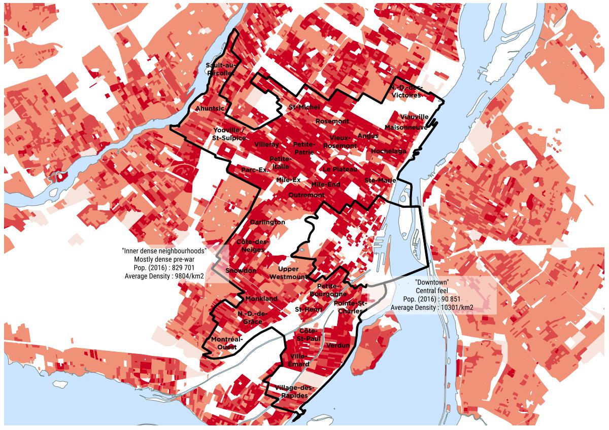


Dense neighbourhoods form a kind of belt around downtown and correspond mostly to what was developed before SWW or around those years. These areas are generally exempt of SFHs.

Around the belt, we could characterize some neighbourhoods as dense suburbia (non-SFH parts of : Saint-Laurent, Bordeaux, Cartierville, Côte-Saint-Luc, Lachine, LaSalle, Île-des-Soeurs, Mercier, Tétraultville, Anjou, Saint-Léonard and Montréal-Nord). Outside of that, the urban fabric looks more like ordinary suburbia.
Reply With Quote
     
     
This discussion thread continues

Use the page links to the lower-right to go to the next page for additional posts
 
 
Reply

Go Back   SkyscraperPage Forum > Regional Sections > Canada
Forum Jump


Forum Jump


All times are GMT. The time now is 6:15 PM.

     
SkyscraperPage.com - Archive - Privacy Statement - Top

Powered by vBulletin® Version 3.8.7
Copyright ©2000 - 2024, vBulletin Solutions, Inc.