 Posted Jul 9, 2022, 1:03 AM
|
|
Registered User
|
|
Join Date: Jan 2015
Location: BC
Posts: 4,305
|
|
Kind of related - and I didn't want to start a new thread for it...
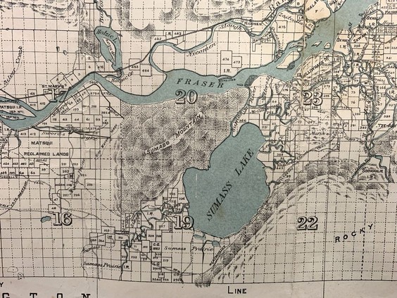
Lost Sumas Lake re-emerges in 1889 map
Quote:
On Oct. 1, 1889, the federal government’s Department of the Interior issued a map of New Westminster District, which basically covered the Fraser Valley from Port Moody to Harrison Lake.
Don Stewart of MacLeod’s Books recently found a copy at an antique store that was closing in Victoria. It’s fascinating to the modern eye, because it shows the location of Sumas Lake, which was drained in the 1920s.
“See how Sumas is spelt, Sumass,” said Stewart, who has the map for sale for $200. “This lake sat in the middle of the countryside, just to the east of Abbotsford.”
The lake was surprisingly large, 36 square kilometres in size, extending from Sumas Mountain in the northwest to Vedder Mountain in the southeast.
Farms now occupy most of the former lake bed on the Sumas Prairie. But the lake more or less reclaimed its natural boundaries last November, when an “atmospheric river” of rain hit the Fraser Valley, drenching it with a record 540 millimetres of water.
The modern take on the draining of the lake is that it was done to create more farmland. But Stewart did some research and found there was another factor: the lake was quite shallow, and was a breeding ground for mosquitoes.
“Part of the reason why it ended up being drained and filled in was the upper Fraser Valley was a centre for malarial disease, and fur traders complained of it,” said Stewart.
...
|

|


 Linear Mode
