| |
 Posted May 5, 2008, 2:51 AM
|
|
Vancouver Moderator
|
|
Join Date: Mar 2007
Posts: 5,747
|
|
|
River District (East Fraserlands) | u/c
Jlousa brought this first to our attention on Feb 5, 2008 on the General Updates thread with a 3D rendering. I just thought it's about time to put this up as it's own seperate thread now. I live actually really close to the area and I can easily provide updates once construction begins.
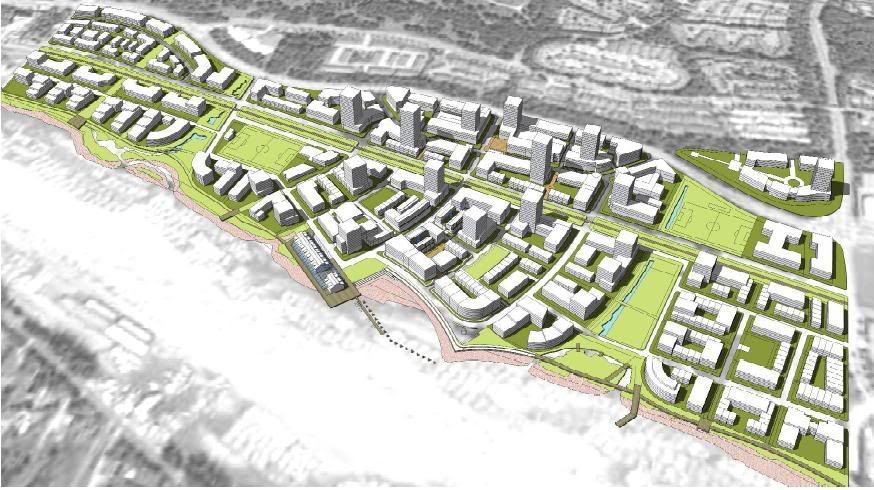 Rendering of East Fraserlands ~ Source: jlousa
Quote:
East Fraserlands - Introduction

Since 2003, the City of Vancouver has been engaged in a planning process to develop a new sustainable, complete community at East Fraserlands – 130 acres of industrial land south of Marine Way and east of Kerr Street to Boundary Road. The site was previously home to the Canadian White Pine Mill and remains zoned for industrial use.
The current plan approved for the site is for a predominantly residential community of approximately 12,800 people in a variety of housing types with a commercial centre in the form of a 'High Street'. The new community would also include parks, a community centre, schools, childcare facilities, a riverfront walk, and other public amenities. The new community would be built out over a period of about 25 years. To view the map of the area, click here.
|
Source: City of Vancouver
Quote:
East Fraserlands - Phase One Rezoning
The City received a rezoning application for phase one of East Fraserlands from the developer ParkLane Homes in February 2007. Proposed in the first phase of development are a variety of housing types, a neighbourhood retail district, a community centre, parks, cycling and pedestrian ways, two day care facilities, a 30,000 square foot community centre, enhancements to the Fraser River foreshore, public art and transit service improvements. The boundaries of the proposed phase one area are shown on the map below.

|
Source: City of Vancouver
Quote:
Overview/Update
After an extensive planning and consultation period, the East Fraserlands project is moving forward through the City of Vancouver's planning and approval process. Below is an overview of this process with updates on the progress of this exciting new waterfront community. Please check back regularly for future updates.
Note: For further information on the City of Vancouver's development and approval processes, please visit www.vancouver.ca.
Step 1: Policy Statement - PROCESS COMPLETED
A policy statement describes the general planning principles that will guide the future development of a site. This document addresses questions of land use, transportation, building form, community facilities and provides broad direction for how those questions will be answered in subsequent planning stages. By representing both public and private interests, a policy statement provides the general framework for further planning and decision-making.
Update: December 2004
The East Fraserlands Policy Statement was unanimously adopted by the Vancouver City Council in December of 2004 following a series of City of Vancouver staff workshops, public open houses and a community workshop.
Step 2: Official Development Plan - PROCESS COMPLETED
An Official Development Plan (ODP) provides a more detailed level of planning by expanding on the ideas established by the Policy Statement. The ODP will present the necessary framework for designing zoning, housing, amenity, servicing, shoreline policies, etc.
Update: February 2006
To initiate the ODP process, ParkLane, WesGroup and the City of Vancouver organized a comprehensive eight day Design Charette in April of 2005 to create a world class plan for the East Fraserlands community. Click here to get more information on this innovative public process, one of the first of its kind in Canada. From the work completed at this charette and subsequent meetings with city staff and the community, ParkLane/WesGroup completed their ODP document and submitted the first draft in January of 2006.
Update: November 2006
On November 14th, 2006, the East Fraserlands (EFL) ODP received unanimous approval by Vancouver City Council. Speaker after speaker from the local community came forward to give their full support of the ODP document and the work completed to date on this new development. The ODP will present the necessary framework for designing, zoning, housing, amenity, servicing, shoreline policies, etc.
Step 3: Rezoning - IN PROGRESS
Zoning guidelines are established by the City of Vancouver and are intended to encourage proper land use and building compatibility. Each area of land in the city has been designated/zoned for a particular use such as industrial, commercial, residential etc. When a landowner wishes to change the zoning of his/her land, he/she must apply to the City of Vancouver for rezoning. Once submitted, this application will be processed through the Director of Planning, the City's Urban Design Panel and City Council. The time required to process a rezoning can vary depending on the complexity of the project.
Update: February 2007
ParkLane/Wesgroup submitted the rezoning application for the first phase of East Fraserlands on February 28th 2007. Proposed in the first phase of development are a variety of housing types, a neighbourhood retail district, parks, cycling and pedestrian ways, daycare facilities, a 30,000 sq. ft. community centre, enhancements to the Fraser River foreshore, public art and transit service improvements.
Click Here for the 1st phase rezoning map
Update: April 2007
On April 24th, 2007 East Fraserlands Master Plan wins Canadian Institute of Planners Award for Excellence. Click here to read our Press Release for more information.
On Wednesday, April the 25th 2007 the Vancouver Urban Design Panel (UDP) reviewed the EFL’s first phase rezoning submission at a marathon session. The rezoning received unanimous approval from the UDP, another remarkable accomplishment for East Fraserlands.
Update: May 2007
The City of Vancouver hosted Open Houses on May 27th and May 30th, 2007 for the community to view and comment on the rezoning application for phase one of the development.
Update: June 2007
East Fraserlands has won the BC Smart Growth Award for best development proposal on June the 1st 2007 presented by the Smart Growth BC Foundation.
Click here to view the press release on this award.
Step 4: Development Permit
A development permit builds upon a rezoning by-law by providing greater detail for a particular building site. The applicant to use or develop property in accordance with the City's zoning regulations
Step 5: Building Permit
A building permit allows the applicant to construct the development proposal.
|
Source: Park Lane Homes
Display Boards compressed to size ~ Source: City of Vancouver
Pictures by Me
This development can be compared to the Olympic Village. Sure it's not in the prime area of Vancouver nor are the buildings as tall, but this development is huge. I can tell you from living in Fraserview that the area is amazing and I didn't realize how large this thing is. Great to see there is some mix retail and office space. The South Marine Drive area is a little too quiet right now, but this would help make things better.
On the transportation side, TransLink has said they would lengthen a few routes to serve this area. Marine Drive is underserved by transit and this development would definetly help link the community with the rest of the region.
- #29 Eliott/29 Ave STN [my route!!!] will go down Eliott then on Marine Way, then to the transit focal point at "the village"
- #26 Joyce/29 Ave STN will change, go down to Kerr then on Marine Way, then to the transit focal point at "the village"
- #116 Edmonds STN/Metrotown STN would reach to the transit focal point at "the village"
- According to the City of Vancouver, piers and dock structures could be used for "future ferry services"
I think the #20 route should reach here too, but I guess TransLink has said no to that. Please note this deata is from 2006 so it might change.
Last edited by deasine; May 6, 2008 at 3:02 AM.
|
|
|


 Prev
Prev


 Linear Mode
