Quote:
Originally Posted by worldwide

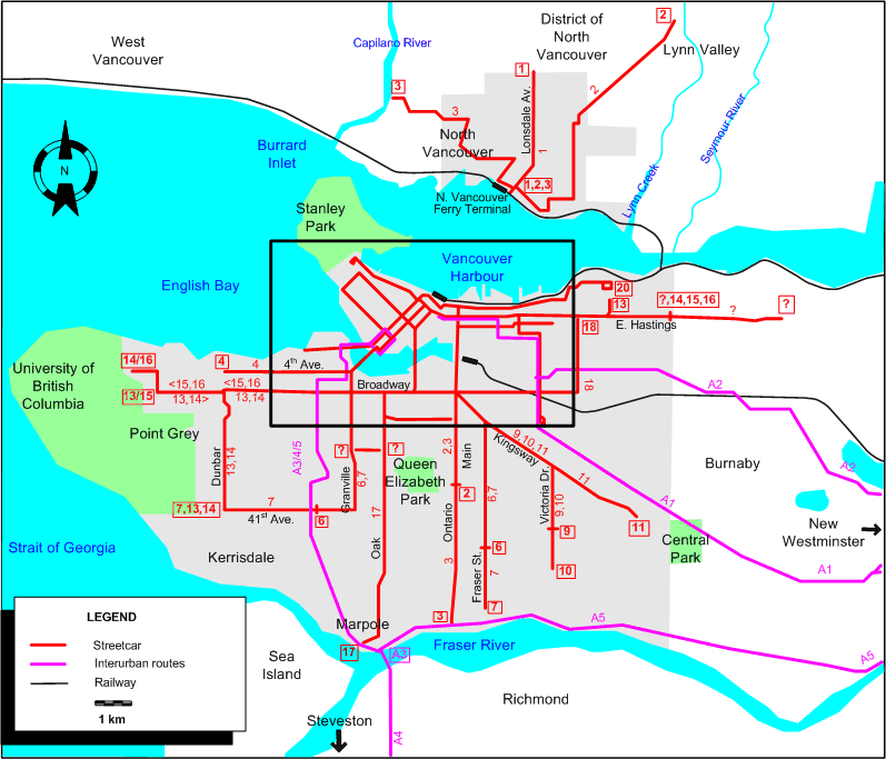
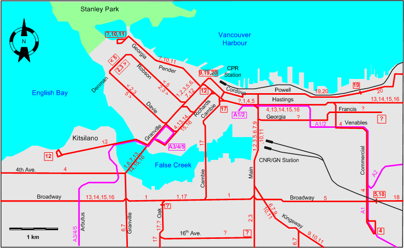
one thing i would say is that your proposed crossing of false creek is really very close to the cambie bridge and the canada line. i would propose to have it run across the burrard bridge instead where it would meet the granville island line at approximately west 7th.
|
I actually was considering Burrard Street as an option... and it was shown on the last streetcar concept. Personal preference for me, but I rather see a new separate cycling, pedestrian, and streetcar bridge in between Granville and Cambie.
I'm seeing a low profile bridge in a shape of a moon crescent from the east side of the soccer field at Charleston Park curving outwards, then inwards to the extended Beach Crescent, or in between the basketball court and the tennis courts west of David Lam Park. Streetcars will then turn right on Homer Street and then left on Pacific Street.
Evidently I need my coffee... because if it follows that alignment... Davie Street is impossible... scatch that. Rename that to Homer St and have a Davie St stop before that.
Quote:
Originally Posted by worldwide
on the kerrisdale line i think that the 12th avenue station is overkill as it really is a short walk to broadway (3 very short blocks)
and there should be either a stop at 33rd or cypress, but not both. the distances between those is negligible.
|
I knew someone would say this. The reason it's the stops are so closely spaced is that I want to replace the 16 trolley with this streetcar. I don't see the point of continuing another electric trolley with a streetcar, or even replacing it with a diesel running side by side with this line. The large intersections (stops) are quite close together anyway, so plugging in smaller stops in between won't make a big difference. Also, I would want a clear distinction between LRT and Streetcar. Since the 16 trolley is replaced with the streetcar, and the streetcar only goes up to 41st Avenue, an extended 100 bus from Marine Dr STN, turning onto Hudson Street, then on 70th Avenue, back on Granville St, and then onto 64th Avenue, and then follow the current 16 Trolley Bus route, then terminating at 41st Avenue/Kerrisdale. Buses would probably be every 15 minutes during peek hours, which would be more than adequate as there is LRT running there. Oh wait... I just realized I didn't post the rest of the updates HAHA I do need my coffee... we will do that when I have everything ready.
Quote:
Originally Posted by worldwide
streetcar on main to 49th, or at least 33rd, would be great. and on the drive
also... Seymour is spelled incorrectly and by homer i think you mean howe (or hornby, but thats backwards down a one way)
|
I was thinking of a Main and Victoria streetcar (I actually took out the Victoria streetcar on this map). I just felt that they at least have an electric trolley (articulated) and it would be better to spend money on building a new cyclist bridge, and primarily focusing the streetcar in downtown. Of course in the long run, the Main and Victoria could be upgraded. I would also like to see more development projects around Main Street corridor and Victoria Drive before they get their rail transit. I know there's that development off Q.E. Park around 33rd Avenue with lots of social housing but god knows when that will be built.
Oh my... spelling mistakes now HAHA. I meant Howe. I will correct all this next time around.


 Prev
Prev


 I need to read abit slower LOL, Thanks I think I'll give it a try.


 I have started my own map using google earth, about 50% done and I will post it if anyone interested. Also I have a Vancouver trollywire overhead map (2003 era) (not made by me), if anyone would like a copy I'll upload that here as well.


 Linear Mode
