HomeDiagramsDatabaseMapsForum About
     

Go Back   SkyscraperPage Forum > Regional Sections > United States > Mountain West


Reply

 
Thread Tools Display Modes
     
     
  #61  
Old Posted Dec 6, 2013, 2:41 AM
RyanD's Avatar
RyanD RyanD is offline
Fast. Fun. Frequent.
 
Join Date: Aug 2010
Location: Denver, Colorado
Posts: 2,987
Quote:
Originally Posted by seventwenty View Post
I think their S.L.U.T. costed $52-56 million for the first 1.3 miles.
I... Ummmm.. Huh... That's just plain bad marketing..
__________________
DenverInfill
DenverUrbanism
--------------------
Latest Photo Threads: Los Angeles | New Orleans | Denver: 2014 Megathread | Denver Time-Lapse Project For more photos check out: My Website and My Flickr Photostream
Reply With Quote
     
     
  #62  
Old Posted Dec 6, 2013, 2:46 AM
seventwenty's Avatar
seventwenty seventwenty is offline
I took a bus pic, CIRRUS
 
Join Date: Mar 2009
Location: Soon to be banned
Posts: 1,697
Quote:
Originally Posted by RyanD View Post
I... Ummmm.. Huh... That's just plain bad marketing..
You kiddin' me? They have t-shirts!

Reply With Quote
     
     
  #63  
Old Posted Dec 6, 2013, 3:26 AM
The Dirt The Dirt is offline
Registered User
 
Join Date: Dec 2007
Posts: 3,212
Genius.
Reply With Quote
     
     
  #64  
Old Posted Dec 6, 2013, 3:59 AM
bunt_q's Avatar
bunt_q bunt_q is offline
Provincial Bumpkin
 
Join Date: Aug 2002
Location: Denver, CO
Posts: 13,203
I think the only time I've ever ridden without paying was on the SLUT this summer.
Reply With Quote
     
     
  #65  
Old Posted Dec 6, 2013, 4:22 AM
Wizened Variations's Avatar
Wizened Variations Wizened Variations is offline
Registered User
 
Join Date: Apr 2008
Posts: 1,611
Let's expand the scope in "Cities" game

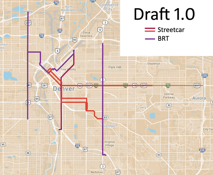
I know, we do tease Aurora like the obnoxious younger sibling we once had, but, I believe that 2nd largest, and 2nd most concentrated population in the Denver area stretches east from Broadway to I-225 between the two cities.

Part of the sales pitch for a very powerful transit system along or closely parallel to, Colfax, should include Aurora. A pitch might be that the 10 to 15 minutes (2.5 to 4 miles) at the east end of the system would certainly help Fitz, err Anschutz and aid redevelopment surround the hospital complex, particularly if the transportation system could T into the I-225 Rail line at the light rail's Colfax Stop.

The West side of I-25 is different, as any north-south line, IMO, should be built south of the Federal Center Station on Kipling (great median right-of-way) to south of US 285.

Perhaps Aurora and Denver might work together (yes, a "little bit of sugar helps the medicine go down...) on the Colfax system, and, Lakewood, piggy back on the technology


**************************

https://www.youtube.com/watch?v=CusLvrjDBXw

The guide wheels would ice up during those rare, but, infamous snow/cold snaps (LOL), but, the presentation is good. The guide wheels narrow the necessary ROW width, and, lower the required support weight if such a system were elevated.

I do believe, however, that a diesel electric bus with variable power abilities to all wheels (electric motor is the differential) might be able to be as effective as this system and not ice up.)

Boulder anyone?
__________________
Good read on relationship between increasing number of freeway lanes and traffic

http://www.vtpi.org/gentraf.pdf
Reply With Quote
     
     
  #66  
Old Posted Dec 6, 2013, 4:41 AM
bunt_q's Avatar
bunt_q bunt_q is offline
Provincial Bumpkin
 
Join Date: Aug 2002
Location: Denver, CO
Posts: 13,203
Quote:
Originally Posted by Wizened Variations View Post
The West side of I-25 is different, as any north-south line, IMO, should be built south of the Federal Center Station on Kipling (great median right-of-way) to south of US 285
This might be the most foolish thing you have ever suggested. If you're into putting rail where there is no appreciable population, might I suggest the Salida to Buena Vista corridor too?

Quote:
Originally Posted by Wizened Variations View Post
I believe that 2nd largest, and 2nd most concentrated population in the Denver area stretches east from Broadway to I-225
Since we're focused on how different the west side is, you'll have to tell me how southwest Denver (say along Federal) is less populated, or suitable for transit, than central Aurora west of 225? Either you're just flat wrong, or you're comparing apples to oranges.
Reply With Quote
     
     
  #67  
Old Posted Dec 6, 2013, 5:20 AM
The Dirt The Dirt is offline
Registered User
 
Join Date: Dec 2007
Posts: 3,212
Suggestion: axe the line to Lower Highland.
Reason: proximity to highway, DUS, and downtown. Shrinking population. High income residents that won't necessarily be swapping their cars for public transit unless it's environmentally trendy. No businesses or commercial space with significant employment numbers to draw commuter traffic to Lower Highland. Restaurants are easier to access by car.

Alternative: extend the line further west into more residential areas (esp. senior housing) that have potential to grow and are within proximity to a commercial corridor (32nd, Speer, and/or Federal).
Reply With Quote
     
     
  #68  
Old Posted Dec 6, 2013, 6:48 AM
bunt_q's Avatar
bunt_q bunt_q is offline
Provincial Bumpkin
 
Join Date: Aug 2002
Location: Denver, CO
Posts: 13,203
Isn't 32nd where folks are in the business of opposing high rises?

If we want it to go where there is room for growth, we're better off with the Portland approach. Send it up Brighton, where there's nothing. And then do everything humanly possible to build up around the thing.

Or Federal, or streets like it. We'll hVe a mighty struggle balancing between current hot spots and future growth areas, because once you get out of the once in a generation open land opportunities like Union Station, those two don't line up in Denver. We only allow growth where there isn't anybody yet.
Reply With Quote
     
     
  #69  
Old Posted Dec 10, 2013, 4:43 AM
Cirrus's Avatar
Cirrus Cirrus is offline
cities|transit|croissants
 
Join Date: Jul 2001
Location: Washington, DC
Posts: 18,384
Can we get back to costs? Here's where I think we are right now. For the preferred answer section, I'm rounding up to account for inflation, and trying to keep to easily multiply-able numbers.

Streetcar Examples:
  • Denver 2010 Colfax study: $40 million per mile for mixed-traffic - this is probably low
  • Tucson construction: $50 M/mi
  • Seattle SLUT: $43 M/mi
  • Oklahoma City: $28 M/mi - but I think that's for substantial sections of single-track.
  • Preferred answer as of now:
    I'd like to have a different number for mixed-traffic & transitway, unless we can link back to something that says they're the same. Just because that's easier to explain. All our examples are mixed traffic. Shall we say $50M/mi for double track mixed traffic & $60M/mi for transitway? Or $40/50? Is a $10M/mi premium for transitway a defendable assumption? Or do we really really just want one number for both?

BRT Examples:
This is going to be trickier because there's so much variety in BRT.
  • Kansas City Main St 2005: $3.5M/mi - marked curbside bus lane, no transitway
  • Kansas City Troost Ave 2011: $2.4M/mi - marked curbside bus lane, no transitway
  • Cleveland: $23M/mi - marked center bus lanes with median stations, no transitway - highest-scoring BRT line in US
  • Las Vegas: $2.8M/mi - mix of mixed traffic and marked lanes, no transit - cost does not include stations or required repaving
  • Still needed: Full-on transitway examples. We could use LA's Orange line, SF's Geary project, or DC's K Street project, but they're likely to to be more expensive because they're in bigger coastal cities. Is there anything in the interior we can use? Eugene's EMX line has its median busway, but nowhere in Denver is going to look like that. Lacking any other info, we could apply whatever we do for streetcar on top of the Cleveland number (like, add $10M/mi).
  • Preferred answer as of now:
    I see 3 potential categories:
    1. Full transitway: No answer yet. Potentially could be $35M/mi (Cleveland + $10M/mi)
    2. Cleveland level (all dedicated lanes, stations with platforms) - $25M/mi
    3. KC/LV level (some dedicated lanes, simpler stops) - $4M/mi
__________________
writing | twitter | flickr | instagram | ssp photo threads
Reply With Quote
     
     
  #70  
Old Posted Dec 13, 2013, 3:06 AM
Cirrus's Avatar
Cirrus Cirrus is offline
cities|transit|croissants
 
Join Date: Jul 2001
Location: Washington, DC
Posts: 18,384
Proposed Draft 1.0:


Notes:
  • 15th / 17th couplet:
    Generally speaking, couplets are bad. They reduce redevelopment benefit and rider simplicity. But they can be worth it sometimes. Ideally I'd prefer to route everything on one street (and I still wonder if 16th wouldn't be the best), but if this is the path of least resistence to having dedicated lanes both ways, then it's probably worth it. I'm assuming we can take 1 lane from both 15th and 17th and dedicate them to transit. Does this make sense?
  • 6th / 8th couplet:
    To be honest, I don't know that much about this part of town. I'm carrying over the 2005 suggestion here, but would prefer to put everything on one street. Would it be practical to move one side or the other?
  • Through streetcars or Union Station hub?
    I'm showing three streetcar lines:
    - Cherry Creek to Union Station
    - Colfax to Union Station
    - Five Points to I-25 / Broadway
    Even assuming this basic three line arrangement makes sense, we could rearrange it so there are four lines, all meeting at Civic Center and then proceeding to Union Station. This would increase service on the downtown spine, but it would reduce some of the utility elsewhere. I picked the Broadway line as the one to continue into Five Points because you already get the light rail connection to Union Station from I-25 / Broadway.
  • Colfax Aurora extension:
    Given it's a different jurisdiction and isn't totally crucial, I am showing this as a possible extension.
  • Welton / Highlands BRT:
    Does this route make sense at all? Really it's 2 routes that I've just arranged as a single through line. Also, this would probably make more sense as a streetcar corridor, but I'm concerned that we have too many of those already, and will not be able to afford more. Certainly if we had to cut one to BRT, this would be the one, right? Is there room on those streets to get dedicated lanes and make it actual BRT?
  • Federal & Colorado BRT
    These are a different sort of line, really. Long, straight, wide roads, less urban. Pretty much perfect for BRT. We could also drop them if we run out of money, although that Glendale-to-I25 connection is very important.
  • Overall cost:
    Back of the napkin estimate is this network would cost around $1.2 billion (see below for breakdown). Is that too much? Or too little?
  • Other comments:
    Please make any route comments you like. You do not have to only respond to my questions.

Costs:
Assuming the cost scenarios I described in my previous post directly above this one, here's what I have this costing, VERY APPROXIMATELY: $1.2 billion
Code:
SEGMENT		MILES	$M/MILE	TOTAL M$
Downtown loop	1.5	$40	$ 60
Colfax Denver	5.5	$40	$220
Colfax Aurora	3.0	$40	$120
Cherry Creek	3.5	$40	$140
Broadway	3.25	$50	$163
Five Points	1.0*	$40	$ 40

Larimer		2.5	$25	$ 62.5
Highlands	2.3	$25	$ 57.5
Federal		6.4	$25	$160
Colorado	6.6	$25	$165

GRAND TOTAL	35.55		$1,188		


* For the Five Points line, I'm only counting the 1/2 of the line that does not yet exist as light rail.
__________________
writing | twitter | flickr | instagram | ssp photo threads
Reply With Quote
     
     
  #71  
Old Posted Dec 13, 2013, 2:35 PM
CharlesCO's Avatar
CharlesCO CharlesCO is offline
Aspiring Amateur
 
Join Date: Jul 2010
Location: Berkeley, CA
Posts: 415
I like that plan, though I'm not sure if I like the idea of a streetcar on 6th and 8th. I don't know if you'd be able to take a lane from each of them, and I don't know if 2 blocks is too far between stations. I would think Speer would have more ROW and would probably be less of a battle to get two lanes from automobiles.
Reply With Quote
     
     
  #72  
Old Posted Dec 13, 2013, 6:00 PM
Cirrus's Avatar
Cirrus Cirrus is offline
cities|transit|croissants
 
Join Date: Jul 2001
Location: Washington, DC
Posts: 18,384
That might be a place to put them in mixed traffic. Better to have them somewhere with a lot of walkable destinations along the line than in the middle of a car-oriented highway. But I'm certainly not married to the alignment.
__________________
writing | twitter | flickr | instagram | ssp photo threads
Reply With Quote
     
     
  #73  
Old Posted Dec 13, 2013, 6:17 PM
bunt_q's Avatar
bunt_q bunt_q is offline
Provincial Bumpkin
 
Join Date: Aug 2002
Location: Denver, CO
Posts: 13,203
Quote:
Originally Posted by Cirrus View Post
That might be a place to put them in mixed traffic. Better to have them somewhere with a lot of walkable destinations along the line than in the middle of a car-oriented highway. But I'm certainly not married to the alignment.
I wrote a lengthy reply and it got lost, AHH.

We reviewed this, Ken and I, with our studio class, and of the entire alignment, I think the 6th/8th portion is the only part all three teams agreed on. Speer is bad for a number of reasons. Among them: it's listed on the National Register, so that adds an element of annoyance; it curves constantly, which makes the trackwork more expensive than it would be on a straighter segment; there are a ton of bridges, which can add significant cost affixing to the bridge deck, and even more if structural changes are needed; the political sensitivities on Speer are generally thought to be MUCH more significant.

6th/8th is also an area where you can pick up some speed, even in mixed traffic. The reality is that Downtown/Cherry Creek is quite long for a streetcar corridor, so you need to make up travel time somewhere. And you have a large area of low density to cross, with minimal development opportunity, no matter which way you go. We are probably looking at 2-4 stations, max, between the Golden Triangle and Cherry Creek. 6th/8th being straight, free-flowing, and relatively uncontroversial (relatively) is a no-brainer.

Also, if you look at the details, there is a great opportunity to sweep across Broadway traffic (from an west-side-running SB route) and turn to the east at 7th, immediately south of the office building there, without having to deal with the MESSY mess at 6th/speer/broadway. It's almost too good to pass up.
Reply With Quote
     
     
  #74  
Old Posted Dec 13, 2013, 8:23 PM
seventwenty's Avatar
seventwenty seventwenty is offline
I took a bus pic, CIRRUS
 
Join Date: Mar 2009
Location: Soon to be banned
Posts: 1,697
Quote:
Originally Posted by Cirrus View Post
Seattle SLUT: $43 M/mi[/i].

This link goes back to my post, and I should clarify something before this draft goes any further: Seattle knew that the South Lake Union Trolley would be reduced to SLUT. So the official name is the South Lake Union Streetcar, or SLUS. The SLUT is just an affectionate name some locals call it, hence the unofficial t-shirt above. I'd feel like an ass if my mild trolling actually made it into something we wanted to present. That said, I still wanna call it the SLUT in informal settings.
Reply With Quote
     
     
  #75  
Old Posted Dec 18, 2013, 6:23 PM
seventwenty's Avatar
seventwenty seventwenty is offline
I took a bus pic, CIRRUS
 
Join Date: Mar 2009
Location: Soon to be banned
Posts: 1,697
At least we're not Cincinnati!

Quote:
Originally Posted by The Atlantic
If Cincinnati isn't careful, its in-progress streetcar system might face a similar fate [to it's aborted 1920s subway system]. Whether or not to finish that project was at the heart of the city's recent mayoral election. Stop-construction candidate John Cranley emerged victorious, and earlier this month the city council put the 3.6-mile project on indefinite pause despite about a half-mile of track already laid.

. . .

The big issue for Cranley and the city council is whether local taxpayers should be on the hook for potential operating costs. The new mayor has said he's willing to let construction continue if private donors come up with enough cash to pay for the first 30 years of running the system — a figure that's reportedly around $80 million. The auditing firm KPMG is expected to release results of a cost analysis sometime today.

Operating costs should indeed be a concern for Cincinnati, especially since reports suggest that streetcar fares will only cover a quarter of those costs. That leaves a pretty large gap, but not an impossible one. If the streetcar's potential for economic development is as large as supporters believe, a local value capture program — through which the city recovers costs from property owners who benefit from the system — should be sufficient to pay for operations. (That said, a streetcar's precise economic value is often quite tough to determine.)
Source


See also this independant audit: http://www.cincinnati-oh.gov/streetc...87/showMeta/0/
Reply With Quote
     
     
  #76  
Old Posted Dec 18, 2013, 6:52 PM
PLANSIT's Avatar
PLANSIT PLANSIT is offline
ColoRADo
 
Join Date: May 2004
Location: Denver
Posts: 2,319
From what I understand regarding the Cincinnati SC, it's more of an Economic Development Tool than a Transportation Tool (not that it's bad, just what it is). As is the case with many of the new SC systems being implemented across the country (OKC, KC, etc). Ridership will likely be on the low end.

Denver, if it ever goes down the SC road, will have a much stronger case as many of the potential corridors will have a huge transportation upside. We'll be able to prove the need for additional capacity/alternatives. And ridership will be impressive.

This is a good thing and will open up a lot of Federal monies for implementation. Cities with ED based systems are left financing most, if not all of it themselves. (Yes, I'm aware that some SC systems received federal help, but really no more than $25 million).
Reply With Quote
     
     
  #77  
Old Posted Dec 18, 2013, 9:08 PM
Cirrus's Avatar
Cirrus Cirrus is offline
cities|transit|croissants
 
Join Date: Jul 2001
Location: Washington, DC
Posts: 18,384
Are there no more comments about routes? I don't believe it...

If we like the network I mapped out above, the next step is to make sure we can lay out a reasonable path to funding a billion-dollar-plus system. If we can't, we'll need to make cuts. It doesn't have to be exact, we just need to know that whatever we say is in the ballpark of the right scale.

So, buntie, whatcha got?
__________________
writing | twitter | flickr | instagram | ssp photo threads
Reply With Quote
     
     
  #78  
Old Posted Dec 18, 2013, 9:19 PM
PLANSIT's Avatar
PLANSIT PLANSIT is offline
ColoRADo
 
Join Date: May 2004
Location: Denver
Posts: 2,319
Only thing I see missing is the possibility of a segment along Colfax between Federal and Broadway. I think there needs to be a more seamless connection with the south side of Auraria (it is the single busiest LRT station in the entire system). I also think there is a ton of demand for a direct (albeit a transfer) connection to SE downtown/Civic Center Station from Decatur-Federal Station (W Line). Maybe it's an alternating E. Colfax train every 15 min. or so?? Just a thought.
Reply With Quote
     
     
  #79  
Old Posted Dec 18, 2013, 9:31 PM
wong21fr's Avatar
wong21fr wong21fr is offline
Reluctant Hobbesian
 
Join Date: Feb 2002
Location: Denver
Posts: 13,162
I'd like to see a line connecting at least one of the stations at Auraria to downtown (the Auraria West station would allow for transfers from the SE, SW and W corridors), this would probably be best to do via a Larimer streetcar line which could then be extended to the 38th and Blake. It also avoids all of the hassle of trying extend the Colfax line from Auraria Colfax to Federal Decatur. Adding another access point to downtown from the west seems like an idea that's just too good to not include.

I'm also all for scrapping the Welton Street/Highlands BRT. The Highlands area just doesn't bring enough ridership.
__________________
"You don't strike, you just go to work everyday and do your job real half-ass. That's the American way!" -Homer Simpson

All of us who are concerned for peace and triumph of reason and justice must be keenly aware how small an influence reason and honest good will exert upon events in the political field. ~Albert Einstein

Reply With Quote
     
     
  #80  
Old Posted Dec 18, 2013, 9:31 PM
Interzen Interzen is offline
Registered User
 
Join Date: Feb 2013
Location: La Alma/Lincoln Park - Denver, CO
Posts: 352
Quote:
Originally Posted by PLANSIT View Post
Only thing I see missing is the possibility of a segment along Colfax between Federal and Broadway. I think there needs to be a more seamless connection with the south side of Auraria (it is the single busiest LRT station in the entire system). I also think there is a ton of demand for a direct (albeit a transfer) connection to SE downtown/Civic Center Station from (W Line). Maybe it's an alternating E. Colfax train every 15 min. or so?? Just a thought.
I'll second the desire for an extension to Decatur-Federal Station to fill the gap left by RTD. I think ridership would be high, particularly at the mentioned Auraria-Colfax station connection where bus transfers are already a significant percentage of the traffic. Unfortunately the river and highway will add greatly to the expense.

I have been trying to find other places to criticize but every time I investigate something I can find no better alternatives.

Full Disclosure: The Colfax extension would also bring the system closer to me personally but I believe I would support it even without the added incentive.

EDIT: Are there more detailed maps of the proposed routes?

Last edited by Interzen; Dec 18, 2013 at 9:54 PM.
Reply With Quote
     
     
This discussion thread continues

Use the page links to the lower-right to go to the next page for additional posts
 
 
Reply

Go Back   SkyscraperPage Forum > Regional Sections > United States > Mountain West
Forum Jump


Forum Jump


All times are GMT. The time now is 10:40 PM.

     
SkyscraperPage.com - Archive - Privacy Statement - Top

Powered by vBulletin® Version 3.8.7
Copyright ©2000 - 2024, vBulletin Solutions, Inc.