HomeDiagramsDatabaseMapsForum About
     

Go Back   SkyscraperPage Forum > Regional Sections > Canada > Ontario > Ottawa-Gatineau > Transportation


Reply

 
Thread Tools Display Modes
     
     
  #1021  
Old Posted Nov 4, 2014, 6:40 PM
harls's Avatar
harls harls is offline
Mooderator
 
Join Date: Jan 2002
Location: Aylmer, Québec
Posts: 19,702
Quote:
Originally Posted by wingman View Post
Agreed. I would like a revisit of the A-550 (a planned connector between the 50 at the curve and the 5 in Chelsea). It would help with the general flow and redirect some rush hour traffic. Though the MTQ said it is not necessary, I drive the 50 almost every day I would disagree.
I thought they would name the section south of that curve 550, and make the 50 continue to A-5 in Chelsea (if that were to ever happen).
Reply With Quote
     
     
  #1022  
Old Posted Nov 4, 2014, 6:51 PM
Acajack's Avatar
Acajack Acajack is offline
Unapologetic Occidental
 
Join Date: Aug 2006
Location: Province 2, Canadian Empire
Posts: 68,143
Quote:
Originally Posted by harls View Post
I thought they would name the section south of that curve 550, and make the 50 continue to A-5 in Chelsea (if that were to ever happen).
It was supposed to also cut through Aylmer and cross the river to link up with the 416 near Bayshore. It was called A-550 or Autoroute Deschênes.
__________________
The Last Word.
Reply With Quote
     
     
  #1023  
Old Posted Nov 9, 2014, 3:45 AM
rocketphish's Avatar
rocketphish rocketphish is offline
Planet Ottawa and beyond
 
Join Date: Feb 2009
Location: Ottawa
Posts: 12,335
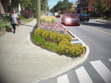
Rain gardens being installed along Sunnyside Avenue

Ottawa East News, Nov 06, 2014
By Michelle Nash


New landscaping features being installed along Sunnyside Avenue aim to help better redistribute storm water in Old Ottawa South.

The “green street” measures on Sunnyside are a part of a larger project focused on creating traffic calming measures for the area, based on the Old Ottawa South area traffic management study, which was completed in 2012. Right now, construction is underway to narrow of the streets, add crosswalks and curb extensions.

Senior project manager Darlene Conway said the city added the idea to build “rain gardens” to the project to improve water quality and reduce runoff into the Rideau River.

“Really it’s the genesis between city staff,” Conway said. “(As part of) the study completed in 2012, we co-ordinated with that group because we wanted to do some storm water management because it’s an old neighbourhood and currently water goes into Rideau River untreated.”

According to the city, rain gardens are planted in areas designed to improve water quality and reduce run-off using a combination of soil, plants, and mulch to treat and absorb storm water run-off. They can be combined with boulevard extensions to serve multiple purposes, including traffic calming, improved aesthetics and storm water management.

There will be three rain gardens, one each at the intersection of Sunnyside and Leonard, Rosedale and Grosvenor avenues. The gardens will trap-capture dirt run-off from the road, which will be treated by the plants and soil and then can safely overflow into the sewer, eventually making its way to the Rideau River.

Conway said that up to 25 millimetres of rain can be treated at one time with the new gardens, which will allow for a bit of “ponding” and release slowly into the drain.

The gardens will be built within the approved traffic calming bulb-outs along Sunnyside.

“This has been made possible because of the other traffic calming measures on the streets,” Conway said.

A pilot project, these gardens will be monitored by Conway and staff over the course of two to three years to see just how successful they can be at treating road run-off.

Conway said this type of treatment has been done in other cities in Canada, but not in Ottawa.

“We have a different climate,” she said. “We haven’t done this thing before, so we will monitor them and track how well it performs.”

The city will test water quality, erosion and flooding impacts.

Conway said the gardens have also been designed to be able to sustain large amounts of snow during the winter.

The plants which will be placed in the gardens Conway said will be hearty, tall plants.

They will offer a bit of green to the streets and for the most part, Conway added most residents have approved of the project.

Residents’ approval is important, Conway said, because the goal is to find Old Ottawa South residents who will be interested in maintaining the garden after the pilot project is complete.

“It would depend on the time of year, but the work could include re-mulching, cutting back dead material in the spring and debris collection,” Conway said. “It would be minimal, but would have to be done at certain times of the year.”

If the pilot project proves to be successful, Conway said the city would look at other urban areas which could benefit from this type of retrofit along aging streets which were developed without proper storm water management.

“We are making a list of older neighbourhoods, inside the greenbelt, not the full area, but the older area which developed without storm water management,” Conway said.

A short section of storm sewer between Bronson Avenue and Sloan Avenue will also be replaced and a section of water main installed at the north end of Sloane Avenue.

The construction will be completed this season, including building the rain gardens but planting will not take place until the spring.

http://www.ottawacommunitynews.com/n...nyside-avenue/
Reply With Quote
     
     
  #1024  
Old Posted Nov 9, 2014, 5:44 PM
acottawa acottawa is offline
Registered User
 
Join Date: Aug 2009
Posts: 15,865
I took a walk down gladstone for the first time since it was reconstructed. It isn't as fancy as some of the reconstructions funded by BIA's but I think it does a good job of actually sharing the street between drivers, pedestrians, cyclists, parkers and drop-offs (most of the apartment buildings have loading zones). It would have been nice to include more bus shelters though (maybe those are coming).
Reply With Quote
     
     
  #1025  
Old Posted Nov 28, 2014, 3:45 AM
MountainView MountainView is offline
Registered User
 
Join Date: Feb 2011
Posts: 1,837
Main Street

Has anyone driven on Main Street recently? I haven't driven on it in at least half a year and can't believe the madness that it has become. I recall that they wanted to make it a more traditional 'main street' but wow...the traffic there is insane now. I guess they recently made the north bound curb lane into a bike lane (still fenced off) and the south bound left lane into turn lanes. Everyone trying to merge over to the right lane makes the street very busy. Unless it is always like this and I am just unaware since I never use the road. Anyways...can someone refresh me on what they are doing to the street.
Thanks all!
Reply With Quote
     
     
  #1026  
Old Posted Nov 28, 2014, 4:18 AM
NOWINYOW NOWINYOW is offline
Registered User
 
Join Date: Mar 2013
Location: Ottawa
Posts: 434
Quote:
Originally Posted by MountainView View Post
Has anyone driven on Main Street recently? I haven't driven on it in at least half a year and can't believe the madness that it has become. I recall that they wanted to make it a more traditional 'main street' but wow...the traffic there is insane now. I guess they recently made the north bound curb lane into a bike lane (still fenced off) and the south bound left lane into turn lanes. Everyone trying to merge over to the right lane makes the street very busy. Unless it is always like this and I am just unaware since I never use the road. Anyways...can someone refresh me on what they are doing to the street.
Thanks all!
I live in Lowertown. Last year, I ended up in an ambulance that was destined to the Ottawa General. I know we went down Main Street.

It's a street necessary for access to the hospital. Too bad nobody told City Council the necessity of well-run roads and streets that directly lead to hospitals should be exempt from vote-getting schemes.

I'd love to see them try the same thing on Carling. Or Baseline. Or Montreal Road.

City Council never ceases to amaze me. All for the sake of a few votes.
Reply With Quote
     
     
  #1027  
Old Posted Nov 28, 2014, 5:26 AM
waterloowarrior's Avatar
waterloowarrior waterloowarrior is offline
National Capital Region
 
Join Date: Nov 2005
Location: Eastern Ontario
Posts: 9,244
Plan is to turn Main in into a complete street, similar to Churchill, with cycle tracks, wider sidewalks, parking, streetscaping etc. The main construction project hasn't started, right now they are doing preliminary utility work. Here's what it should look like.
http://documents.ottawa.ca/sites/doc..._update_en.pdf

more info here
http://ottawa.ca/en/city-hall/planni...street-renewal
http://capitalward.ca/index.php/43-n...ic-disruptions
http://capitalward.ca/index.php/43-n...ay-november-22

Last edited by waterloowarrior; Nov 28, 2014 at 5:43 AM.
Reply With Quote
     
     
  #1028  
Old Posted Nov 28, 2014, 5:41 AM
waterloowarrior's Avatar
waterloowarrior waterloowarrior is offline
National Capital Region
 
Join Date: Nov 2005
Location: Eastern Ontario
Posts: 9,244
Found a recent update for the Hospital Link...

Alta Vista Transportation Corridor – Project Overview
Updated October 2014
http://ottawa.ca/en/city-hall/planni...rridor-project

Project description
The project provides a link between Riverside Drive and the Transitway to the Hospital Ring Road. This link is needed to improve transit service to the Hospital Complex and support ongoing hospital and local development including the NDMC Lands. The Hospital Link will comprise of a 2‐lane facility with provisions for transit lanes and multi‐use pathways.

Spring 2015 construction activities
  • Construction of temporary detour alignments along Riverside Drive to accommodate bridge foundation construction
  • Large diameter watermain relocation
  • Bridge foundation construction
  • Rail diversion in preparation for new rail bridge construction

2015 to 2017 construction activities
  • Construction of 3 bridges (Riverside Drive overpass, Transitway overpass and Rail underpass)
  • Construction of sewers and watermains
  • Construction of a 2 lane road from Riverside Drive to the Hospital Ring Road including Alta Vista intersection reconstruction

Timelines
Start of construction – Spring 2015
Substantial completion – Fall 2017. Separate landscape contract to commence in 2018.
Reply With Quote
     
     
  #1029  
Old Posted Nov 28, 2014, 3:33 PM
1overcosc's Avatar
1overcosc 1overcosc is offline
Registered User
 
Join Date: Jun 2013
Location: Kingston, Ontario
Posts: 11,482
Main Street will flow better once the project is complete and it's a one-lane road in each direction uniformly. Right now the merges created by construction are just a complete mess.

As for hospital access... shouldn't that be 417->Riverside->Smythe and soon to be 417->Riverside->Hospital Link?

As for Carling... it absolutely should be narrowed east of the 417, from 6 lanes to 4 lanes. It's massively overbuilt in its current state and even at the peak of rush hour there's never any congestion there. Heck, by the farm you can jaywalk across it even at 8 in the morning because of how many empty gaps there are.
Reply With Quote
     
     
  #1030  
Old Posted Nov 28, 2014, 6:16 PM
rocketphish's Avatar
rocketphish rocketphish is offline
Planet Ottawa and beyond
 
Join Date: Feb 2009
Location: Ottawa
Posts: 12,335
Main Street rebuild to cause major traffic disruptions
Northbound traffic to be detoured during two-year reconstruction project

Ottawa East News, Nov 21, 2014
By Laura Mueller


Motorists can expect significant traffic impacts when Main Street is reconstructed over the next two years to replace century-old water and sewer infrastructure.

Plans revealed at an open house on Nov. 20 show the main artery in Old Ottawa East will be closed to northbound traffic between Greenfield and Riverdale avenues in the first phase of construction starting next spring. There will be one northbound lane available for local traffic only from Riverdale to Clegg Street.

In the second construction phase, no northbound traffic at all will be allowed on Main between Greenfield and Riverdale.

The open house on Nov. 20 was well-attended and people had a lot of questions, said John Dance, president of the Old Ottawa East Community Association.

“The construction will be very disruptive but it's the price we have to pay to have modern water and sewer lines and a safe, friendly street,” Dance said.

The construction will lead to a host of important and long-awaited improvements for the neighbourhood, Dance said. Main Street itself will get the addition of bicycle lanes in the form of raised cycle tracks – a useful addition as the community just outside the downtown swells with the development of 10 hectares of institutional land formerly occupied by the Oblate fathers, Dance said.

The street rebuilding is also creating an opportunity for the city and the National Capital Commission to work together to create a safe pedestrian crossing at Colonel By Drive and Clegg by adding a traffic signal. It’s something residents in the area have been requesting for 30 years, Dance said.

The Brantwood Memorial Gates, which are on their last legs, will also be rebuilt as part of the project, Dance said.

But right now, the focus is on the short-term pain that will result in the long-term gain.

“There remain lots of questions and issues but from what we've seen so far city staff (has) been accommodating in trying to minimize adverse impacts on residents and businesses,” Dance said.

The construction is set to wrap up in the summer of 2017, but the duration of each construction phase hasn’t been determined. Final plans will be presented at another open house in the spring, once a contractor is hired.

The northbound restrictions are not the only snarls for drivers. Sections of Main Street at its north and south ends – between Hawthorne and Lees Avenue and between Riverdale and Clegg – will be reduced to one lane travelling in each direction.

Only local traffic is planned to be allowed on the south section of Main, from the Smyth Road side of the McIlraith Bridge to around Elliot, and the north block between Greenfield and Colonel By.

Northbound bus detours are still being determined and the city is asking for suggestions from the public.

Drivers heading downtown will either be rerouted west on Clegg either to Glenora Street, Hazel Street and Echo Drive, or onto Colonel By Drive, depending on whether the National Capital Commission gives its permission for the second option. Drivers will then head west on Graham to reconnect with Main Street.

Utility work

Some construction is already underway related to utilities. Bell Canada is replacing its underground ducts.

The work involves removing the surface above the duct, which includes sidewalks, grass and roadway in some areas.

Temporary lane reductions have already begun between Hawthorne and Greenfield, but long-term lane closures were set to begin on Nov. 22. One lane in each direction will be closed between Lees and Clegg due to the work being done through the winter under snowy conditions, according to Josée Vallée, the city’s project manager for Main Street.

Temporary asphalt will be used to patch up the work until the full construction project begins.

http://www.ottawacommunitynews.com/n...c-disruptions/
Reply With Quote
     
     
  #1031  
Old Posted Nov 28, 2014, 6:26 PM
phil235's Avatar
phil235 phil235 is offline
Registered User
 
Join Date: Sep 2006
Location: Ottawa
Posts: 3,765
Quote:
Originally Posted by NOWINYOW View Post
I live in Lowertown. Last year, I ended up in an ambulance that was destined to the Ottawa General. I know we went down Main Street.

It's a street necessary for access to the hospital. Too bad nobody told City Council the necessity of well-run roads and streets that directly lead to hospitals should be exempt from vote-getting schemes.

I'd love to see them try the same thing on Carling. Or Baseline. Or Montreal Road.

City Council never ceases to amaze me. All for the sake of a few votes.
Complete streets are not a vote-getting scheme, they are good planning, plain and simple. As noted, it's quite likely that traffic will flow as well or better once the changes are made, while actually giving some thought to people using the street who are not in cars. Sorry to say, but 60's planning is on the outs, and not just in Ottawa.

Right now, other than in rush hour, Main Street is dramatically under capacity. A four-lane expanse of pavement is not exactly a wise use of public resources.

In any event, I don't think there is much evidence that the complete streets idea was used to get votes. It was the entire city council that voted on the plan. Most councillors represent the suburban commuter set and have nothing to gain.
Reply With Quote
     
     
  #1032  
Old Posted Nov 28, 2014, 10:43 PM
eternallyme eternallyme is offline
Registered User
 
Join Date: Mar 2009
Posts: 5,243
Re: the Main Street project, with only one lane available:

* Southbound buses and local traffic should be maintained on Main Street, and northbound moved to Marlowe Crescent. Route 5 buses would go Riverdale --> Elliot (temporary through lane for buses only) --> Marlowe --> Clegg --> Main, if local residents approve. The alternative is signal controlled contraflow on Main Street.

* Through traffic would be strictly prohibited, with extremely high fines.

* The Hawthorne-Lees detour should have special signal timing, so buses in both directions use the single lane.
Reply With Quote
     
     
  #1033  
Old Posted Dec 6, 2014, 8:14 PM
rocketphish's Avatar
rocketphish rocketphish is offline
Planet Ottawa and beyond
 
Join Date: Feb 2009
Location: Ottawa
Posts: 12,335
NCC holds open house for Clegg crossing
Signalized crossing planned for spring 2015

Ottawa East News, Dec 04, 2014
By Michelle Nash


The National Capital Commission will present designs for a new signalized crossing at Clegg Street and Colonel By Drive during a Dec. 11 open house.

Working with the city on the project, the NCC’s open house will take place from 5:30 to 8 p.m. at Saint Paul University, in Laframboise Hall. The evening will showcase the proposed improvements such as the installation of a traffic light which would be activated by pedestrians and cyclists as needed at Colonel By and Clegg Street.

According to NCC spokesman Cédric Pelletier, the NCC, in partnership with the city, intends to move forward with the planned improvements in the spring 2015.

“The NCC’s objective is to move forward with a design that will maintain the NCC’s parkways standards, that will improve the level of comfort and safety of pedestrians and cyclists crossing the intersection, and that will satisfy the City of Ottawa requirements,” Pelletier said.

The proposed design requires the closure of Echo Drive at Clegg Street and additional pavement markings and support signage is also being considered.

Pelletier said it is too early to determine the budget for the Clegg crossing. To date, an estimated $25,000 has been set aside for the planning and design work phase.

The work is being conducted by internal staff; the cost includes the number of hours staff spent on the project.

Once in place, this will be the third crossing improvement the NCC has implemented following a 2011 Rideau Canal Pedestrian Crossing Study.

The goal of the study was to identify key crossing points and develop solutions to allow for use of the area all year long and included input from community associations, special interest groups and representatives from both the city’s universities.

The other two crossings are a pedestrian crossing on Colonel By Drive, behind Carleton University and most recently a signalized crossing at Queen Elizabeth Drive and Fifth Avenue.

The crossing at Queen Elizabeth and Fifth was designed to connect with a future pedestrian and cycling bridge over the canal to Clegg Street.

The proposed footbridge is pegged at a $17.5 million cost, but the city has no plans to build it until 2020 or 2021.

When the NCC completed the Queen Elizabeth crossing and officially opened it in July, nearby Old Ottawa East residents then questioned when a similar crossing would be completed on their side of the canal -- something the community has been wanting for the past 30 years.

At the time, NCC chief executive Mark Kristmanson said there were no immediate plans or money to build its twin across the canal at Clegg.

However, news of plans to move ahead with a crossing at Clegg Street came in mid-August.

The crossing can also be considered a small part of another larger project, Main Street reconstruction, which will begin next spring.

A crossing at Clegg could come in handy as the street is being considered as a potential detour route during the construction.

The designs will be posted on the NCC’s website, ncc-ccn.gc.ca after the open house, on Dec. 12.

http://www.ottawacommunitynews.com/n...legg-crossing/
Reply With Quote
     
     
  #1034  
Old Posted Jan 24, 2015, 5:12 AM
Cre47's Avatar
Cre47 Cre47 is offline
Awesome!
 
Join Date: Mar 2006
Location: Orleans, ON
Posts: 1,971
Construction of Widening of Trim Road (at Watters, at St-Joseph and at Portobello) - note the speed is 50 km/h

https://www.google.ca/maps/@45.48506...YdgCdVWW2g!2e0

https://www.google.ca/maps/@45.48898...Se3vjRpTrg!2e0

https://www.google.ca/maps/@45.47830...ETNQ!2e0?hl=en

Jockvale Road south of Longfields - speed limit is 60 km/h there but construction wasn't quite finished

https://www.google.ca/maps/@45.26027...9oHh-Yd5nw!2e0

The quite empty Strandherd (now Vimy) Bridge - speed limit of 70 km/h on the bridge (basically maintaining the constancy of speed from between Greenbank and Spratt)

https://www.google.ca/maps/@45.27033...QkcchUaySw!2e0

https://www.google.ca/maps/@45.38325...t4Qp9CRupg!2e0 (Hunt Club Road at the 417 - only section of the new extension)

The Greenbank and Old Richmond/Stonehaven projects haven't started yet in the updates
__________________
"However, the Leafs have not won the Cup since 1967, giving them the longest-active Cup drought in the NHL, and thus are the only Original Six team that has not won the Cup since the 1967 NHL expansion." Favorite phrase on the Toronto Maple Leafs Wikipedia page.

Last edited by Cre47; Jan 24, 2015 at 4:51 PM.
Reply With Quote
     
     
  #1035  
Old Posted Feb 18, 2015, 11:20 PM
waterloowarrior's Avatar
waterloowarrior waterloowarrior is offline
National Capital Region
 
Join Date: Nov 2005
Location: Eastern Ontario
Posts: 9,244
Display boards for Colonel By/Clegg crossing
http://www.ncc-ccn.gc.ca/sites/defau...11-12-2014.pdf
Reply With Quote
     
     
  #1036  
Old Posted Feb 27, 2015, 3:10 PM
waterloowarrior's Avatar
waterloowarrior waterloowarrior is offline
National Capital Region
 
Join Date: Nov 2005
Location: Eastern Ontario
Posts: 9,244
Proposed Roadway Modifications

Pursuant to By-law No. 2006–483, the City of Ottawa is providing notice to the public of its intention to approve road modifications at the following locations in accordance with the authority under By-law No. 2011-28:

Bronson Avenue at Colonel By Drive Ramp
  • Installation of mid-block traffic control (pedestrian/bike signal) on Bronson Avenue at the existing recreational pathway to Carleton University, located approximately 170 m south of the Bronson Avenue Bridge;
  • Ramps (access to/from Colonel By Drive, Bronson Place) modification on Bronson to improve existing cycling and pedestrian facilities;
  • Sidewalk upgrade as required on Bronson Avenue between Colonel By Drive Ramps and Sunnyside Avenue;
  • Implementation of raised cycle tracks as required on east and west side of Bronson Avenue, north of proposed controlled crossing;
  • Implementation of new cycling facilities to provide access between proposed controlled crossing and Bronson Place;
  • Removal of 3 m section median on Bronson Place at Fulton Avenue for cycling access;
  • Sidewalk extension along southbound Bronson Avenue to Colonel By Drive ramp; and,
  • Modification of curb radius on south west quadrant at the intersection of Colonel By Drive at Bronson Place. This curb realignment also includes realignment of concrete sidewalk and modifications to the existing pedestrian facilities.

Colonel By Drive at Clegg Street & Echo Drive
  • Installation of a new traffic signal at the intersection of Colonel By Drive and Clegg Street;
  • The formalization of the motor vehicle access restriction on the south leg of Echo Drive, replacing the three unmaintained planters with permanent hardscaping;
  • The implementation of a motor vehicle access restriction on the north leg of Echo Drive, in the form of permanent hardscaping;
  • The construction of new concrete sidewalks across the north and south legs of Echo Drive to provide improved pedestrian access to the canal multi-use pathway;
  • The construction of new cycle tracks across the north and south legs of Echo Drive to provide improved cyclist access to the canal multi-use pathway; and
  • The construction of a bi-directional dedicated cycling link to allow north-south bicycle traffic on Echo Drive to safely cross Clegg Street at a crossride on the east side of the proposed signalized intersection of Colonel By Drive and Clegg Street.


Also some uninteresting suburban site access modifications
Reply With Quote
     
     
  #1037  
Old Posted Feb 27, 2015, 11:25 PM
OttawaSteve's Avatar
OttawaSteve OttawaSteve is offline
Registered User
 
Join Date: Sep 2008
Location: Ottawa
Posts: 161
Quote:
Originally Posted by waterloowarrior View Post
Proposed Roadway Modifications

Bronson Avenue at Colonel By Drive Ramp
  • Installation of mid-block traffic control (pedestrian/bike signal) on Bronson Avenue at the existing recreational pathway to Carleton University, located approximately 170 m south of the Bronson Avenue Bridge;
  • Ramps (access to/from Colonel By Drive, Bronson Place) modification on Bronson to improve existing cycling and pedestrian facilities;
  • Sidewalk upgrade as required on Bronson Avenue between Colonel By Drive Ramps and Sunnyside Avenue;
  • Implementation of raised cycle tracks as required on east and west side of Bronson Avenue, north of proposed controlled crossing;
  • Implementation of new cycling facilities to provide access between proposed controlled crossing and Bronson Place;
  • Removal of 3 m section median on Bronson Place at Fulton Avenue for cycling access;
  • Sidewalk extension along southbound Bronson Avenue to Colonel By Drive ramp; and,
  • Modification of curb radius on south west quadrant at the intersection of Colonel By Drive at Bronson Place. This curb realignment also includes realignment of concrete sidewalk and modifications to the existing pedestrian facilities.
I wholeheartedly welcome any measures to modify the way that pedestrians, cyclists, and vehicles interact in this area. The current setup is a nightmare for cyclists on Bronson, obviously, but also for pedestrians, mainly due to the presence of those freeway-style ramps to/from Colonel By and the lead-footed airport cab drivers that ply them.

Still, I'm surprised that the mid-block pedestrian signals to cross Bronson are justified here. The well-used Carleton pathway meets Bronson on the west side, yes, but there is no real origin/destination on the east side of Bronson here.
Reply With Quote
     
     
  #1038  
Old Posted Feb 27, 2015, 11:48 PM
waterloowarrior's Avatar
waterloowarrior waterloowarrior is offline
National Capital Region
 
Join Date: Nov 2005
Location: Eastern Ontario
Posts: 9,244
Quote:
Originally Posted by OttawaSteve View Post
I wholeheartedly welcome any measures to modify the way that pedestrians, cyclists, and vehicles interact in this area. The current setup is a nightmare for cyclists on Bronson, obviously, but also for pedestrians, mainly due to the presence of those freeway-style ramps to/from Colonel By and the lead-footed airport cab drivers that ply them.

Still, I'm surprised that the mid-block pedestrian signals to cross Bronson are justified here. The well-used Carleton pathway meets Bronson on the west side, yes, but there is no real origin/destination on the east side of Bronson here.
The biggest advantages are from the connections to the north (Glebe) and northeast (NCC Pathways), who will have a more direct route and also avoid the busy Bronson/Sunnyside intersections.
Reply With Quote
     
     
  #1039  
Old Posted Feb 28, 2015, 3:29 AM
eternallyme eternallyme is offline
Registered User
 
Join Date: Mar 2009
Posts: 5,243
The whole area needs a complete rethink. IMO, Bronson and the Airport Parkway need to be separated (i.e. send Bronson directly into Carleton). But finding a connection north will be a challenge...in a way, the Champagne Expressway might have been useful?
Reply With Quote
     
     
  #1040  
Old Posted Feb 28, 2015, 1:19 PM
daud's Avatar
daud daud is offline
Registered User
 
Join Date: Jun 2012
Location: Ottawa
Posts: 739
Quote:
Originally Posted by eternallyme View Post
The whole area needs a complete rethink. IMO, Bronson and the Airport Parkway need to be separated (i.e. send Bronson directly into Carleton). But finding a connection north will be a challenge...in a way, the Champagne Expressway might have been useful?
Living in the south end I have thought about this. I would say that you could have the airport parkway merge with riverside at bronson then have traffic move NE. Build a bridge to connect to nicholas which is part of the long term plan anyways. This would create a north south route and eliminate the need for the alta vista parkway.

If you look at riverside between bronson and hurdman, there is very little preventing it from being upgraded, there's just the bank st intersection. Smyth is already an interchange.

The city caved to various neighbourhoods over the years and as such we are left without a good north south corrider for vehicles. Same thing happened in Toronto with the Allen Expressway. It stops dead at Eglinton. This results in cars driving down residential areas, collector roads and interacting with pedestrians. People hate highways, but they divert large amounts of traffic

Also, I personally think this proposed connection should a)connect to Hwy 5 and b) the airport parkway should extend south to an expanded Leitrim, which should one day be a 417-416 link, airport highway and ottawa bypass.

But I am dreaming...Ottawa doesn't build highways. We build 4 lane roads with traffic lights.
Reply With Quote
     
     
This discussion thread continues

Use the page links to the lower-right to go to the next page for additional posts
 
 
Reply

Go Back   SkyscraperPage Forum > Regional Sections > Canada > Ontario > Ottawa-Gatineau > Transportation
Forum Jump


Forum Jump


All times are GMT. The time now is 7:37 AM.

     
SkyscraperPage.com - Archive - Privacy Statement - Top

Powered by vBulletin® Version 3.8.7
Copyright ©2000 - 2024, vBulletin Solutions, Inc.