HomeDiagramsDatabaseMapsForum About
     

Go Back   SkyscraperPage Forum > Discussion Forums > Transportation


Reply

 
Thread Tools Display Modes
     
     
  #1  
Old Posted Jun 13, 2012, 10:58 AM
mrnyc mrnyc is offline
cle/west village/shaolin
 
Join Date: Jul 2006
Posts: 11,739
smartphone transit app discussion

please discuss city mass transit smartphone apps here. apologies if there already is a thread if so mods feel free to merge.

i just downloaded the new nyc mta weekender app. looks good so far. the service line updates are what you come for and the layout is clean and clear. useful bonuses include isolated maps of each line (w/ the map ghosted in the background) and neighborhood maps of each stop which is nice. it remains to be seen how they handle weekend service disruptions.

for a quick reference/regular map of the nyc subway i use kicklite. its fine.

for tokyo i have the tokyo metro app. it did all i needed. would be nice if they added neighborhood maps for each stop particularly as the many unnamed streets can be a bit confusing.

for istanbul i used two. metro ulasim was just fair. however, another istanbul app, otobus, was excellent and very useful. you can plan out point to point trips on the city bus system and it shows you the route. its in turkish so you have to learn a bit of turkish and play with it a bit, but its intuitive and the language learning curve is steep so you will quickly figure it out.

so what transit apps do you all use?
Reply With Quote
     
     
  #2  
Old Posted Jun 13, 2012, 12:20 PM
tayser's Avatar
tayser tayser is online now
Vires acquirit eundo
 
Join Date: Mar 2002
Location: Melbourne
Posts: 3,231
Tram Tracker

Real time info of the next three trams, really good map integration + GPS and pretty much makes the timetables/real time info signs at stop irrelevant. USe very frequenty.

It can also give you directions to the nearest tram stop.

download it, just turn all the find nearest/gps off and then find Melbourne on the map and zoom right in - tap a stop and the info will show


PTV

for everything else, unfortunately our train network is not integrated with GPS so no real time info, but they've basically taken all the good parts of tram tracker and put it in a Bus + Train + Tram timetable app with all the "Find the nearest
" type features.

both were developed by / on behalf the respective tram and train+bus operators (PTV is the umbrella org that brings all the info together) & both are free.
Reply With Quote
     
     
  #3  
Old Posted Jun 13, 2012, 1:46 PM
emathias emathias is offline
Adoptive Chicagoan
 
Join Date: Sep 2007
Location: River North, Chicago, Illinois
Posts: 5,157
There are several for Chicago. For ones that developers tell the CTA about, they list them on their website here.

On the PC I just use the CTA's own tracker website.

On my phone, which is Android, I've used the CTA's website, which is optimized for mobile and actually works pretty well for the basics, and have also used "Chicago Transit Tracker" which was the first good Android app for bus tracking.
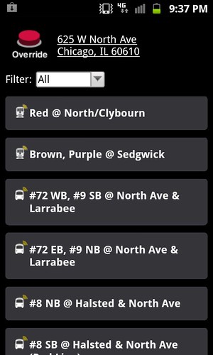
Currently I use TreKing, which uses the CTA's data to provide real-time tracking of CTA buses and CTA trains and scheduled Metra (commuter rail) and Pace (suburban bus system) timetables (Metra and Pace don't have real-time tracking data, at least not publicly available).

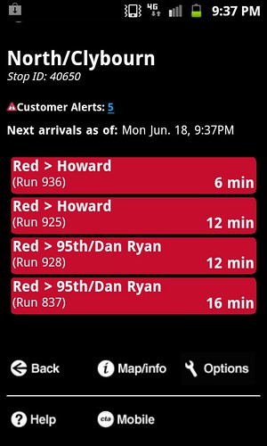
It really does make a difference. Since this has been available, I've been much more likely to take the bus than I used to be. Previously I would just get a taxi rather than wait an unknown amount of time for a bus. Now I know if there's one coming in 4-5 minutes I'll wait. And if I'm not too busy, I'll sometimes wait even longer rather than spring for a taxi, confident I won't be there for 45 minutes late at night.

Chicago does sometimes have "ghost buses" that aren't transmitting their location and show up unannounced, but that doesn't happen too frequently. I can tell a lot of people do use the bus tracking, though, because ghost buses nearly always have noticeably fewer riders than ones that show up on the tracker tools. I usually email the CTA when I get on a ghost bus, just to make sure they know about it.
Reply With Quote
     
     
  #4  
Old Posted Jun 13, 2012, 5:34 PM
Standpoor's Avatar
Standpoor Standpoor is offline
Registered User
 
Join Date: Jan 2010
Posts: 188
While not an app, currently I am infatuated with CTA Discover, which is in beta right now.
discover.transitchicago.com

It uses gps to give you all bus and train stops near your location and lets you check when the next train/bus will come. I have a shortcut on my home screen, so one touch and I can see all the stops around me regardless of where I am in the city. Another touch and I can see arrival times or get walking directions to the stop. Compared to the train/bus tracker website, it makes things a lot easier while on the go.
Reply With Quote
     
     
  #5  
Old Posted Jun 14, 2012, 8:21 PM
M II A II R II K's Avatar
M II A II R II K M II A II R II K is offline
Registered User
 
Join Date: Aug 2002
Location: Toronto
Posts: 52,200
The new iPhone won't have transit directions, just driving.
__________________
ASDFGHJK
Reply With Quote
     
     
  #6  
Old Posted Jun 14, 2012, 9:12 PM
emathias emathias is offline
Adoptive Chicagoan
 
Join Date: Sep 2007
Location: River North, Chicago, Illinois
Posts: 5,157
Quote:
Originally Posted by M II A II R II K View Post
The new iPhone won't have transit directions, just driving.
Seriously? They're gonna piss off a lot of New York, Boston, Chicago, San Francisco, Washington users.
Reply With Quote
     
     
  #7  
Old Posted Jun 14, 2012, 9:21 PM
M II A II R II K's Avatar
M II A II R II K M II A II R II K is offline
Registered User
 
Join Date: Aug 2002
Location: Toronto
Posts: 52,200
http://dc.streetsblog.org/2012/06/13...obile-devices/

Quote:
Yesterday Apple announced details for iOS 6, the new operating system for iPad and iPhone, and it looks like transit directions will be casualties of the company’s decision to drop Google Maps as its default map application. The new, Apple-developed map application will include driving directions and walking directions, but no transit information, at least not standard. Instead, if you want to figure out how to get somewhere without driving, users will have to download a third-party application.

.....
__________________
ASDFGHJK
Reply With Quote
     
     
  #8  
Old Posted Jun 14, 2012, 9:55 PM
zilfondel zilfondel is offline
Submarine de Nucléar
 
Join Date: Mar 2006
Location: Missouri
Posts: 4,477
Transit is so crappy in my city that I stopped using mass transit.

There, I said it.
Reply With Quote
     
     
  #9  
Old Posted Jun 14, 2012, 10:07 PM
emathias emathias is offline
Adoptive Chicagoan
 
Join Date: Sep 2007
Location: River North, Chicago, Illinois
Posts: 5,157
Quote:
Originally Posted by zilfondel View Post
Transit is so crappy in my city that I stopped using mass transit.

There, I said it.
I kept telling people that, but no one wanted to hear it.
Reply With Quote
     
     
  #10  
Old Posted Jun 14, 2012, 10:32 PM
Minato Ku's Avatar
Minato Ku Minato Ku is offline
Tokyo and Paris fan
 
Join Date: Jul 2006
Location: Paris, Montrouge
Posts: 4,168
I have three app.
-RATP app for metro, RATP bus, tram and RATP RER.
It provides everything, traffic, real-time schedule, map of the network, map by line, district map around station, it can calculate the best itinerary for a journey.
-SNCF Transilien app, it is about the same for SNCF suburban and RER trains.
-Via Navigo.
It provides itinerary for every networks of the Paris area. It is made by the STIF, the regional transport organisation authority.

Because I live on RATP network, I mostly use the RATP one, there is no Transilien railway lines or other bus network near my home.
Reply With Quote
     
     
  #11  
Old Posted Jun 18, 2012, 7:56 PM
cabasse's Avatar
cabasse cabasse is offline
Registered User
 
Join Date: Jun 2002
Location: atalanta
Posts: 4,173
marta is pretty slow at getting their act together. their buses do all have gps devices for location tracking, through two similar reporting sites. (spice.ridecell.com and webwatch.itsmarta.com) ridecell no longer reports, but an android app exists on google play. (with no data, of course) i know there's also a marta-branded app on apple's app store but i have no idea whether or not it's functional.

basically, it's half assed just like the transit system itself...
__________________
Reply With Quote
     
     
  #12  
Old Posted Jun 19, 2012, 2:47 AM
Standpoor's Avatar
Standpoor Standpoor is offline
Registered User
 
Join Date: Jan 2010
Posts: 188
I am bored and want to keep the thread going so I will show you how CTA Discover works. I am pretty sure this was developed internally and is a great system. At first I just dealt with the website on my laptop which was not helpful at all but after fiddling around with my phone I am quite impressed.

First, I have a bookmark on my homepage that links directly with the site.
[IMG[/IMG]
It automatically finds your location based on GPS or you can manually put in an address.

It gives you all the train and bus stops around your location based on distance from where you are standing. I have it setup where it gives me the train stops first whether or not it is the closest transit option then gives buses based on distance from my location.

Tapping on any stop gives the next train/bus.

Then you can get maps and directions to the stop as well.


There you have it.
Reply With Quote
     
     
  #13  
Old Posted Jun 19, 2012, 3:39 AM
jtk1519's Avatar
jtk1519 jtk1519 is offline
Registered User
 
Join Date: Dec 2006
Posts: 975
I find DART's mobile site to be useful with pretty accurate info, but more often than not I use the HopStop app. In the past I have used QikRide and AnyStop: Dallas DART but I really like HopStop. Better interface and more accurate IMO.
__________________
"I do not feel obliged to believe that the same God who has endowed us with sense, reason, and intellect has intended us to forgo their use." -- Galileo
Reply With Quote
     
     
  #14  
Old Posted Jun 19, 2012, 1:48 PM
fishrose's Avatar
fishrose fishrose is offline
Registered User
 
Join Date: Oct 2009
Location: Midtown Detroit
Posts: 570
Quote:
Originally Posted by zilfondel View Post
Transit is so crappy in my city that I stopped using mass transit.

There, I said it.
Try living in Detroit.

DDOT is supposed to be releasing a smartphone app this fall for tracking the buses via GPS. Hopefully they will support multiple platforms. The majority of DDOT riders who actually have smartphones are using MetroPCS prepaid Android phones. If all DDOT releases is an iPhone app (Wayne State did this for a while, and it was very frustrating) it will be pretty useless. The buses have had GPS for years now, but it's never been utilized in any real capacity, not even to evaluate route performance.
Reply With Quote
     
     
  #15  
Old Posted Jun 19, 2012, 5:50 PM
M II A II R II K's Avatar
M II A II R II K M II A II R II K is offline
Registered User
 
Join Date: Aug 2002
Location: Toronto
Posts: 52,200
The Upside of iPhones Without Google Transit Directions


June 18, 2012

By Angie Schmitt

Read More: http://dc.streetsblog.org/2012/06/18...it-directions/

Quote:
.....

The Apple Maps app will provide driving and walking directions, but transit riders will have to access third-party plug-ins to figure out the best way from point A to point B. While that could pose a hurdle for millions of iPhone and iPad users, the new system could also encourage the creation of a much richer assortment of transit apps for mobile devices, according to Kevin Webb, who develops mapping and trip planning tools at OpenPlans, Streetsblog’s parent organization.

- One possible reason is that Google’s free tools de-incentivize others from entering the market. iPhone and Android users have had little reason to download alternate apps, especially paid ones, when the pre-installed features solve much of the need. Unlike many other Google technologies, there’s no current option to extend the functionality for transit or other directions, or incorporate this data into non-Google app. There’s tremendous opportunity for innovation in how we design and communicate information about personal mobility. Unfortunately the tools have not kept pace, in part due to a lack of proper incentives for new services. With iOS 6, Apple is building a market for new tools rather than offering a default solution.

.....
__________________
ASDFGHJK
Reply With Quote
     
     
  #16  
Old Posted Jun 20, 2012, 11:44 AM
mrnyc mrnyc is offline
cle/west village/shaolin
 
Join Date: Jul 2006
Posts: 11,739
Quote:
Originally Posted by jtk1519 View Post
I find DART's mobile site to be useful with pretty accurate info, but more often than not I use the HopStop app. In the past I have used QikRide and AnyStop: Dallas DART but I really like HopStop. Better interface and more accurate IMO.

oh i forgot about hopstop. its very popular for nyc too, i think it was developed here first, not sure. but yeah it gives step by step directions, neighborhood maps and maybe best of all it outlines the walk from where you are to the transit stop. i would highly recommend it for tourists or for locals venturing into unknown neighborhoods. use in it conjunction with kicklite, which is a simple map of the subway system. i have the hopstop app, but dont use it for whatev reason. not sure other cities they have rolled out into, but it would be excellent for visitors if available.
Reply With Quote
     
     
  #17  
Old Posted Jun 20, 2012, 11:58 AM
mrnyc mrnyc is offline
cle/west village/shaolin
 
Join Date: Jul 2006
Posts: 11,739
the cleveland rta website has two useful features i have used, alerts and nextconnect. there is also a transit guru cle app available that you have to pay for. looks like there is opportunity for those near eastside tech startup wizzes to do more with cleveland transit!
Reply With Quote
     
     
  #18  
Old Posted Jun 23, 2012, 3:44 PM
M II A II R II K's Avatar
M II A II R II K M II A II R II K is offline
Registered User
 
Join Date: Aug 2002
Location: Toronto
Posts: 52,200
OnTheBus Brings the Usefulness of GPS to the Visually Impaired

Read More: http://www.good.is/post/onthebus-bri...ally-impaired/

Quote:
.....

A new Android app called OnTheBus is a guide for people who need to get around big cities with public transportation, but unlike other GPS programs, the app uses gesture and voice recognition to be especially helpful for people with "visual, hearing, or cognitive impairments."

A bevy of features make the app more accessible. There's voice recognition and highly detailed spoken instructions about which bus route to take, what bus stops you're passing along the way, how long the bus will take to arrive, and how to navigate from your bus stop to your final destination. Rather than typing out each individual letter of a street address, users can draw the letters on a touch pad with their finger, and the app will match it up with the likely destination.

.....


__________________
ASDFGHJK
Reply With Quote
     
     
  #19  
Old Posted Jul 3, 2012, 2:11 PM
M II A II R II K's Avatar
M II A II R II K M II A II R II K is offline
Registered User
 
Join Date: Aug 2002
Location: Toronto
Posts: 52,200
Can IBM eggheads slay Boston’s traffic woes?


Jun. 29, 2012

By Barb Darrow

Read More: http://gigaom.com/cloud/can-ibm-eggh...-traffic-woes/

Quote:
.....

Boston won the opportunity to pick the brains of six IBM engineers — including one from Tokyo — who flew in to check out its traffic situation and figure out a way to consolidate, analyze and use existing traffic data feeds as well as new data sources including (of course) Twitter feeds, to ease the city’s notorious traffic jams.

- The Internet of things links data flowing from traffic lights, CO2 sensors, even cars themselves, in a way that could automate traffic re-routing in what could be a time- and gas-saving assist for commuters. “There are literally millions of data points per second — from GPS and cellphone technology — that can be analyzed and made intelligent,” Steve Wysmuller, an IBM Global Services exec, told the Globe. The IBM experts, along with techies from Boston University and the Boston’s Office of New Urban Mechanics, were to come up with a plan to better manage traffic — by spotting problems faster — and to minimize carbon emissions with better bicycling, parking and traffic management policies, according to the City’s web site.

.....


__________________
ASDFGHJK
Reply With Quote
     
     
  #20  
Old Posted Jul 3, 2012, 6:38 PM
scalziand's Avatar
scalziand scalziand is offline
Mortaaaaaaaaar!
 
Join Date: Aug 2007
Location: Naugatuck, CT/Worcester,MA
Posts: 3,506
The Boston MBTA has a page that lists all the transit apps available.

http://www.mbta.com/rider_tools/apps/
Reply With Quote
     
     
This discussion thread continues

Use the page links to the lower-right to go to the next page for additional posts
 
 
Reply

Go Back   SkyscraperPage Forum > Discussion Forums > Transportation
Forum Jump


Forum Jump


All times are GMT. The time now is 9:57 AM.

     
SkyscraperPage.com - Archive - Privacy Statement - Top

Powered by vBulletin® Version 3.8.7
Copyright ©2000 - 2024, vBulletin Solutions, Inc.