HomeDiagramsDatabaseMapsForum About
     

Go Back   SkyscraperPage Forum > Regional Sections > Canada > Alberta & British Columbia > Vancouver > Transportation & Infrastructure


Reply

 
Thread Tools Display Modes
     
     
  #901  
Old Posted Mar 18, 2014, 3:14 PM
Genauso's Avatar
Genauso Genauso is offline
A hole being Doug
 
Join Date: Dec 2013
Posts: 498
Surrey can't even support a bus network today and all the areas naturally more desirable to live (near the coast, on a hill, etc) will grow a lot more in the time span considered. Richmond and Delta ALR, UBC endowment land will be greenfield developments and already developed areas will be redeveloped much quicker than they have been as the baby boomer demographic sell their homes. Compare Dunbar, Kerrisdale, and Kitsilano to the eastern parts of the city that developed later.

I do think region building policies have left east-west traffic underserved at present, but I expect the stand out change at 2050 to be the north-south traffic as the prime coastal areas develop. Maybe not to the extent of a Horseshoe Bay to Tsawassen ferries line, but closer to that than a Langley-Surrey line.

What that will do then is to support growth of neighboring areas and enable much cheaper and more valuable links for Surrey and New Westminster. The connectivity will end up looking more like a spider web, or overlapping webs, instead of trying to keep all stations/lines as far apart in the name of regional fairness.

As it is, for now we grow at a slow enough rate that we need to see the demand existing for the minimum level of service before we build anything, building to create demand slows everything. So much will change, transit is on a popular upswing in North America now which is also to say that has not always been the case. Self-driving cars that park themselves are on the horizon, which is a big time saving and the next big wave of public transit investment might have to wait until there is integration with local package delivery and emergency services.
Reply With Quote
     
     
  #902  
Old Posted Mar 18, 2014, 4:19 PM
Prometheus's Avatar
Prometheus Prometheus is offline
Reason and Freedom
 
Join Date: Jul 2009
Location: Vancouver/Toronto
Posts: 4,015
Quote:
Originally Posted by LeftCoaster View Post

The hastings line is apparently a contentious one, with more than just you hesitating at it, but for me it is a no brainer.
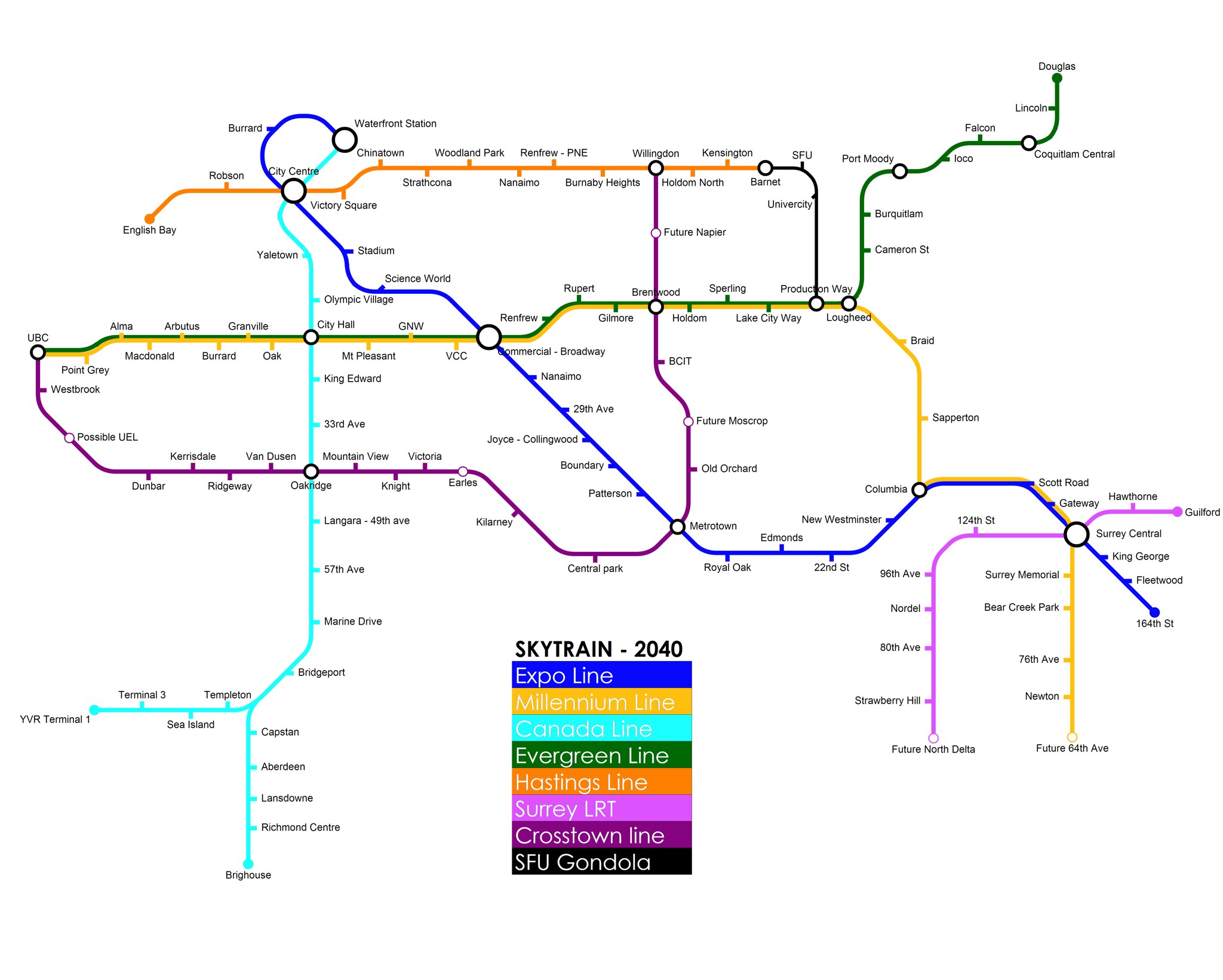
It's absolutely a no brainer that the Hastings Line will be the next RRT line built in the City of Vancouver after the UBC Line and that East Hastings will be the next great redeveloped corridor after the redevelopment of Cambie. Indeed, the urbanization along East Hastings will be more robust and consistent than what is envisioned in the Cambie Corridor Plan. (Of course, the West Broadway corridor will see substantial redevelopment too, but the changes will seem less transformational because it is already significantly urbanized.)

LeftCoaster, I would argue that the Hastings Line would actually be extended even further east to the very base of Burnaby Mountain to Dalla Tina Ave. A highly dense urban village would be built around the terminus on this parcel of land. And the Burnaby Mountain Gondola would actually connect to this terminus, not Production Way on the Millennium Line.

However, whether the west end of the Hastings Line follows something like your plan or terminates at Waterfront Station is an open question.

Last edited by Prometheus; Mar 18, 2014 at 4:35 PM.
Reply With Quote
     
     
  #903  
Old Posted Mar 18, 2014, 5:22 PM
wrenegade's Avatar
wrenegade wrenegade is offline
ON3P Skis
 
Join Date: Sep 2008
Location: Lower Lonsdale, North Vancouver, BC
Posts: 2,593
Leftcoaster, love the map. One question and one comment though. First, shouldn't "Westbank" out at UBC be "Westbrook"? And on the Hastings line, how come it wasn't extended up the hill to SFU? Too expensive? Don't think the ridership is there?
__________________
Flickr
Reply With Quote
     
     
  #904  
Old Posted Mar 18, 2014, 9:51 PM
Millennium2002 Millennium2002 is offline
Registered User
 
Join Date: Jun 2009
Posts: 1,742
Quote:
Originally Posted by wrenegade View Post
Leftcoaster, love the map. One question and one comment though. First, shouldn't "Westbank" out at UBC be "Westbrook"? And on the Hastings line, how come it wasn't extended up the hill to SFU? Too expensive? Don't think the ridership is there?
If a SkyTrain line were built to SFU, it'd basically be one of those super-deep-level stations with only elevator or deep escalator access. And despite the fact that Portland has its Washington Park station in a hill, I'm pretty sure that doing something similar with SFU would be a highly-controversial and possibly budget-breaking endeavour.
Reply With Quote
     
     
  #905  
Old Posted Mar 18, 2014, 10:04 PM
Steveston Steveston is offline
Registered User
 
Join Date: Sep 2011
Posts: 472
@ Leftcoaster:

Love the map. Hate to be a nit-picker, but...

On the Canada Line, the future Capstan Stn is south of the YVR/Brighouse split (along the Brighouse leg), which occurs immediately south of Bridgeport Stn.
Reply With Quote
     
     
  #906  
Old Posted Mar 19, 2014, 2:41 PM
LeftCoaster's Avatar
LeftCoaster LeftCoaster is offline
Moderator
 
Join Date: Nov 2005
Location: Toroncouver
Posts: 12,634
Quote:
Originally Posted by Prometheus View Post
LeftCoaster, I would argue that the Hastings Line would actually be extended even further east to the very base of Burnaby Mountain to Dalla Tina Ave. A highly dense urban village would be built around the terminus on this parcel of land. And the Burnaby Mountain Gondola would actually connect to this terminus, not Production Way on the Millennium Line.
That's what I wanted to do as well, but I ended it short in this phase. I've got another idea that I'll put in the revised version though.

Quote:
Originally Posted by wrenegade View Post
Leftcoaster, love the map. One question and one comment though. First, shouldn't "Westbank" out at UBC be "Westbrook"?
Haha whoops, good eye. I'll make that change.

Quote:
Originally Posted by Steveston View Post
@ Leftcoaster:

Love the map. Hate to be a nit-picker, but...

On the Canada Line, the future Capstan Stn is south of the YVR/Brighouse split (along the Brighouse leg), which occurs immediately south of Bridgeport Stn.
Yep, good point, don't know what it's doing up there. Thanks for the heads up. Nit pickers are appreciated.
Reply With Quote
     
     
  #907  
Old Posted Mar 19, 2014, 8:05 PM
officedweller officedweller is online now
Registered User
 
Join Date: Jul 2001
Location: Vancouver
Posts: 38,359
Quote:
Originally Posted by LeftCoaster View Post
Nit pickers are appreciated.
Okay, I'll be nit picky:

Granville Station should probably continue to be marked separately from City Centre Station

Lincoln will be the only station between Coquitlam Central and Douglas. There's no space for another station.

Cameron is not even a future station anymore, as there won't be a flat section of guideway.

I think there's still the possibility of a future West Port Moody Station.

Being optimistic, add Woodlands Station between Columbia and Sapperton.

As a side note, I've always thought the Hastings Line would be an eastwards extension of the Expo Line from Waterfront Station.
Reply With Quote
     
     
  #908  
Old Posted Mar 19, 2014, 8:28 PM
LeftCoaster's Avatar
LeftCoaster LeftCoaster is offline
Moderator
 
Join Date: Nov 2005
Location: Toroncouver
Posts: 12,634
Quote:
Originally Posted by officedweller View Post
Okay, I'll be nit picky:

Granville Station should probably continue to be marked separately from City Centre Station

Lincoln will be the only station between Coquitlam Central and Douglas. There's no space for another station.

Cameron is not even a future station anymore, as there won't be a flat section of guideway.

I think there's still the possibility of a future West Port Moody Station.

Being optimistic, add Woodlands Station between Columbia and Sapperton.

As a side note, I've always thought the Hastings Line would be an eastwards extension of the Expo Line from Waterfront Station.
Someone finally noticed my new City Centre Station! There will no longer be two stations there but three lines converging into a new Massive connected interchange. The two existing lines will be connected by the third Hastings line. Picture a big sprawling interchange like Dhoby Ghaut in Singapore.

Re Coquitlam don't know why I thought Coquitlam (Coquitlam Centre) and Lincoln were different stations. I've fixed that.

Is Cameron flat out impossible now? That's a bummer, I really wanted a station there.

Where is woodlands slated to go? Or is that just a vision of yours? Either way that stretch of Millennium is pretty light so I'll go ahead and add it.
Reply With Quote
     
     
  #909  
Old Posted Mar 19, 2014, 8:55 PM
LeftCoaster's Avatar
LeftCoaster LeftCoaster is offline
Moderator
 
Join Date: Nov 2005
Location: Toroncouver
Posts: 12,634
Here's a rough idea of what I was thinking for City Centre Interchange:


https://farm4.staticflickr.com/3739/...29edf7cc_o.jpg
Reply With Quote
     
     
  #910  
Old Posted Mar 19, 2014, 9:07 PM
rsxstock rsxstock is offline
Registered User
 
Join Date: Apr 2013
Posts: 274
cant they stack the station so you go up and down instead?
Reply With Quote
     
     
  #911  
Old Posted Mar 19, 2014, 9:43 PM
officedweller officedweller is online now
Registered User
 
Join Date: Jul 2001
Location: Vancouver
Posts: 38,359
Quote:
Originally Posted by LeftCoaster View Post
Someone finally noticed my new City Centre Station! There will no longer be two stations there but three lines converging into a new Massive connected interchange. The two existing lines will be connected by the third Hastings line. Picture a big sprawling interchange like Dhoby Ghaut in Singapore.
I was thinking that's what you envisaged, but I think the Granville name would still stick.
Remember, the ticketing halls for Granville Station are under Seymour St. and under The Hudson (along Dunsmuir).
and the platforms are under Dunsmuir St. roughly centred on Seymour St.

Here's the newer part under the Hudson. You can also see the older passages under Seymour St.

http://www.via-architecture.com/proj...ville-station/

Quote:
Where is woodlands slated to go? Or is that just a vision of yours? Either way that stretch of Millennium is pretty light so I'll go ahead and add it.
At the end of the New West tunnel where the line flies over the railway tracks.

http://www.whatthehelvetica.ca/2010/...train-station/

Last edited by officedweller; Mar 19, 2014 at 10:02 PM.
Reply With Quote
     
     
  #912  
Old Posted Mar 21, 2014, 8:11 PM
LeftCoaster's Avatar
LeftCoaster LeftCoaster is offline
Moderator
 
Join Date: Nov 2005
Location: Toroncouver
Posts: 12,634
Only reason I changed it to Granville is because I had another Granville station on the Millennium/Evergreen extension, thought it made more sense for that and to rename the mega station City Centre.

anyway here's a new map based off the changes you guys reccommended. ONly changes I didn't make were to extend the expo line, metro level rail to Langley still doesn't make much sense to me, and I forgot to add in woodlands, but use your imagination on that one.


Thoughts on the update?
Reply With Quote
     
     
  #913  
Old Posted Mar 21, 2014, 10:01 PM
Axe Axe is offline
Registered User
 
Join Date: Oct 2009
Posts: 61
Looks great. Only thing i think you are missing is the Port Coquitlam Extension of the evergreen line. I think that would happen before other lines on your map.
Reply With Quote
     
     
  #914  
Old Posted Mar 27, 2014, 6:04 PM
LeftCoaster's Avatar
LeftCoaster LeftCoaster is offline
Moderator
 
Join Date: Nov 2005
Location: Toroncouver
Posts: 12,634
I have the evergreen extension in my next phase.

One of the big issues I have with this layout is that if Evergreen and Millennium are interlined any split in the evergreen will result in a max frequency of about 8 minutes per train on either split of evergreen. Maybe it could be every six or so but that still isn't great.
Reply With Quote
     
     
  #915  
Old Posted Mar 27, 2014, 9:02 PM
officedweller officedweller is online now
Registered User
 
Join Date: Jul 2001
Location: Vancouver
Posts: 38,359
Maybe there would be a PoCo-Douglas shuttle to fill the time gaps (although the Douglas to PoCo leg woud have to run all the way to the VSF).

Quote:
Originally Posted by nname View Post
The almost-full contract for Evergreen Line is released here (under procurement documents, project agreement/schedule)

...

And this is what I gather from Appendix I - the potential track map for the line! This document is even older though (dated 2011) - it still have Cameron station, so I just put it in!

Note: VSF = Vehicle Storage Facility... it is actually just lots of parallel tracks
Reply With Quote
     
     
  #916  
Old Posted Mar 28, 2014, 4:32 AM
jbrizzy jbrizzy is offline
Registered User
 
Join Date: May 2011
Location: Vancouver
Posts: 129
Just to point out, leftcoaster, the UBC line station at granville will most be named south granville.
Reply With Quote
     
     
  #917  
Old Posted Mar 28, 2014, 6:05 PM
officedweller officedweller is online now
Registered User
 
Join Date: Jul 2001
Location: Vancouver
Posts: 38,359
Also, no station is planned at Burrard on the UBC Line, because its so close to both Granville and Arbutus.
Only the LRT combination options contemplate a station at Burrard - located near 5th Ave. where the CPR RoW crosses Burrard.
Reply With Quote
     
     
  #918  
Old Posted May 15, 2014, 1:26 AM
gkz gkz is offline
Registered User
 
Join Date: Jul 2013
Posts: 71
I have an updated map based on, as much as possible, actual translink plans, community development plans, etc.

Vancouver 2050 - Skytrain

Google Maps:
https://mapsengine.google.com/map/u/...o.kyJD1KKTdMd4

Assumptions:
Upgraded Lion's Gate Bridge, new Oak Street Bridge.

Preview:

https://mapsengine.google.com/map/u/...o.kyJD1KKTdMd4

Last edited by gkz; May 15, 2014 at 11:24 PM.
Reply With Quote
     
     
  #919  
Old Posted May 15, 2014, 7:46 PM
officedweller officedweller is online now
Registered User
 
Join Date: Jul 2001
Location: Vancouver
Posts: 38,359
I think Arbutus has more of a chance connecting to Marine Dr. Station and then New Westminster than going to Richmond.
Reply With Quote
     
     
  #920  
Old Posted May 15, 2014, 11:24 PM
gkz gkz is offline
Registered User
 
Join Date: Jul 2013
Posts: 71
Quote:
Originally Posted by officedweller View Post
I think Arbutus has more of a chance connecting to Marine Dr. Station and then New Westminster than going to Richmond.
That line is not on Arbutus, it is on Granville - which I think makes more sense than Arbutus. Essentially the Canada Line is doubled, with the current one on Cambie going to Richmond, and the Granville portion going to the Airport. They share Bridgeport, City Centre, and Waterfront.
Reply With Quote
     
     
This discussion thread continues

Use the page links to the lower-right to go to the next page for additional posts
 
 
Reply

Go Back   SkyscraperPage Forum > Regional Sections > Canada > Alberta & British Columbia > Vancouver > Transportation & Infrastructure
Forum Jump


Forum Jump


All times are GMT. The time now is 9:49 AM.

     
SkyscraperPage.com - Archive - Privacy Statement - Top

Powered by vBulletin® Version 3.8.7
Copyright ©2000 - 2024, vBulletin Solutions, Inc.